Wat Sa Si
A causeway crosses water toward a Sukhothai reliquary and walking Buddha
Understand sacred places, explore living traditions, and learn how to engage respectfully with Pilgrim Map.
Access has not been verified. Check current local guidance before planning a visit.
Mueang Kao, Sukhothai, Thailand
Read the sources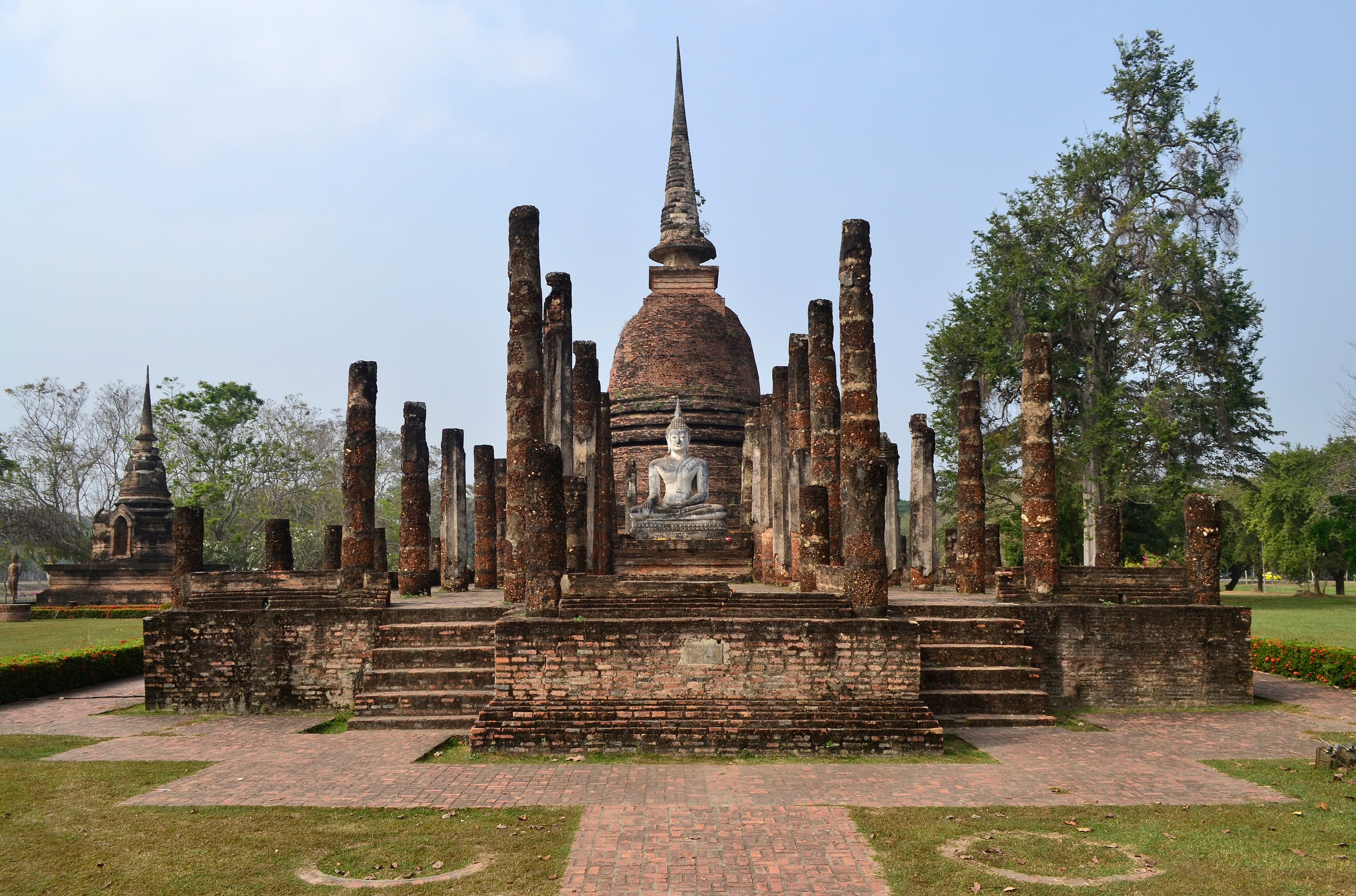
Wat Sa Si in Mueang Kao, Sukhothai, Thailand. Image source · CC BY-SA 4.0
Visit essentials
A quick read before you go
- Etiquette
- Stay off foundations, image bases, water edges, vegetation, and every closed route.
Overview
Water slows the approach before any image appears closely. On the island, a bell-shaped chedi carries relic-stupa meaning, while surviving Buddha images present stillness and movement as complementary signs of the path. The walking Buddha, a celebrated Sukhothai form, turns awakening into poised action rather than immobility. A hall and boundary markers show that the island supported communal rites and ordination, not only private contemplation.
The temple's sacred coherence comes from these relationships: causeway, water, reliquary, image, and bounded monastic space.
Why this place is sacred
Reflections and morning mist can make the island appear detached from ordinary ground. That visual experience may feel contemplative, but it is not evidence that the water generates a spiritual energy. The historical sacred boundary is more precise. Crossing the causeway moved practitioners from the town toward a defined Buddhist enclosure; the chedi and images then organized recollection, homage, and merit. Modern photography often isolates the walking Buddha against sunset.
A responsible reading restores the supporting monastery and avoids treating one silhouette as a generic symbol of inner peace.
Experience and orientation
Pause before the bridge to understand the whole island, then cross without blocking the narrow route. Locate the principal chedi, seated image, walking Buddha, and ordination markers as separate evidence. Do not step onto foundations for reflections or pose against Buddha images. Water edges can be slippery and vegetation may conceal uneven masonry. If a ceremony or conservation closure changes circulation, follow park staff. The site rewards a short, deliberate route more than hurried movement between photo points.
Quiet observation is appropriate even though no resident sangha is verified. Listen for how water changes nearby sound, but describe that sensory effect without turning it into an ancient ritual claim.
Context and lineage
Fine Arts documentation places Wat Sa Si within the planned sacred landscape of Sukhothai and identifies its island position and principal monuments. The Sri Lankan bell form reflects religious connections that shaped Sukhothai Buddhism, while the walking Buddha represents a locally distinctive artistic achievement. Archaeology and restoration make the compact plan visible today. UNESCO inscribed Sukhothai, Si Satchanalai, and Kamphaeng Phet together in 1991 as property 574.
That status applies to the historic-town ensemble; it does not authenticate every modern spiritual interpretation of the pond or sunset.
Traditions and practice
Historical use included Buddha-image worship, stupa reverence, monastic activity, and ordination within a marked boundary. Contemporary visitors should not light incense on old brick, leave flowers in the pond, walk on image bases, or invent a water purification rite. A bow or a quiet pause from the public route can acknowledge the Buddhist purpose. The island has no verified active monastery or named pilgrimage program, so the page classifies current practice as heritage stewardship rather than claiming uninterrupted ceremony.
Theravada Buddhism
HistoricalHistoric Theravada practice joined stupa homage, Buddha images, ordination, and monastic life.
Heritage stewardship
ActivePark management protects causeway, pond, monuments, and sight lines as one archaeological ensemble.
Perspectives and open questions
Iconography, reliquary studies, landscape history, archaeology, and conservation each explain a layer.
Scholarly perspective
Buddhist iconography distinguishes the seated and walking images; reliquary studies interpret the bell chedi; landscape history explains the ritual force of an island reached by causeway. Archaeology defines halls and boundaries, while conservation manages water, vegetation, and masonry together. UNESCO situates the temple inside a serial cultural property. These lenses make the site spiritually specific without calling it a natural sacred place. The pond contributes designed setting and visitor experience, not a documented independent deity or supernatural power.
Plan your visit
The existing strong Places record confirms the exact component; park rules override reported continuous access.
Respectful visit
Stay off foundations, image bases, water edges, vegetation, and every closed route.
Current practical details
Address
2P92+VHV, Mueang Kao, Mueang Sukhothai District, Sukhothai 64210, Thailand
Hours
Hours, fees, and access can change — verify on the official source before you travel. Practical details last checked Jul 2026.
Location
Map loads as you approach this section.
Pilgrim reflections
A portrait of encounter, not a score
Pilgrims describe what they felt, how present they could become, and whether the place would shape a journey. There are no stars and no ranking of traditions.
No reviewed reflections yet
The first pilgrims can help describe the character of being here.
Share a reflection
Available after an account-backed “Been there.” Every reflection is reviewed before publication.
Nearby sacred places
Explore other sacred places in the region. Proximity does not establish access or travel time; check each place’s guidance.

References
Sources consulted for this page. Source categories describe the publication, not a guarantee that every claim is verified. Traditional accounts and outside interpretations may differ.
- 01Sukhothai Historical Park guide — Fine Arts DepartmentofficialOfficial exact-site inventory, island setting, architecture, Buddha images, and park context.
- 02Historic Town of Sukhothai and Associated Historic Towns — UNESCO World Heritage CentreofficialAuthoritative inscription, component scope, criteria, and management context.
- 03Wat Sa Si — Google Maps — Google PlacesSource contextStrong name, country, locality, and type match; used only for identity and practical visitor fields.
Pilgrim glossary
- Stupa
- A dome-shaped Buddhist monument that holds relics or marks a sacred place.
- Sangha
- The community of Buddhist practitioners, traditionally monks and nuns.
Share a photo
Help visitors recognize Wat Sa Si. Every submission is reviewed before publication.