Country guide
United States
The United States sacred-site map spans Indigenous homelands, mission churches, Marian shrines, contemplative monasteries, desert pilgrimage landscapes, and newer places of spiritual gathering.
132 sacred sites across 75 regions. Use the tradition and site-type filters to narrow in.
Atlas summary
United States sacred sites overview
Sacred sites in the United States are often best understood by region: Southwestern ceremonial landscapes, Catholic and Orthodox pilgrimage shrines, Native American sacred mountains, healing springs, and urban houses of worship all sit in the same atlas.
Use this page to move from broad geography into specific traditions and site types, then compare individual site pages for access notes, cultural context, and nearby sacred places.
| Coverage | 132 sacred sites across 75 regions. |
|---|---|
| Regional clusters | |
| Traditions | |
| Site types | |
| UNESCO heritage | 6 UNESCO-tagged sites in this country guide. |
By tradition
Showing 1-48 of 181 sites in this country guide
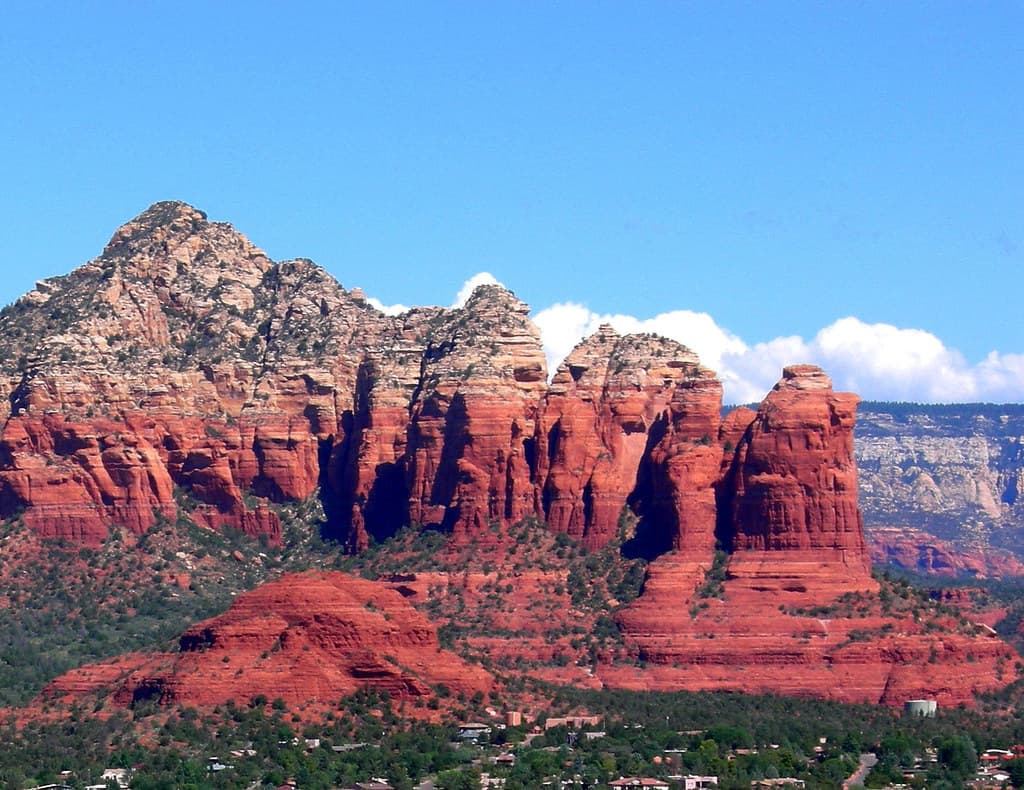
Airport Mesa, Sedona
Sedona, Arizona, United States
Perched above Sedona with 360-degree views of the red rock landscape, Airport Mesa offers the most accessible encounter with vortex energy....

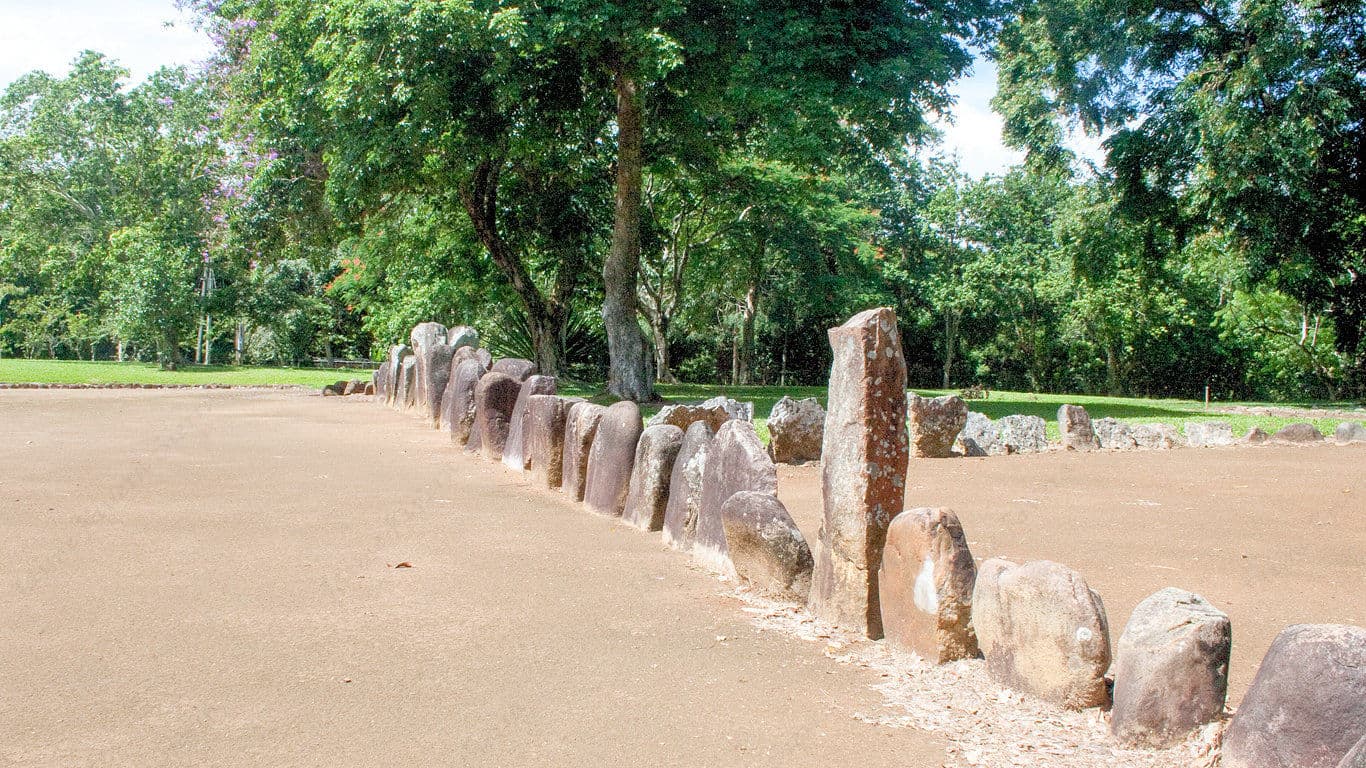
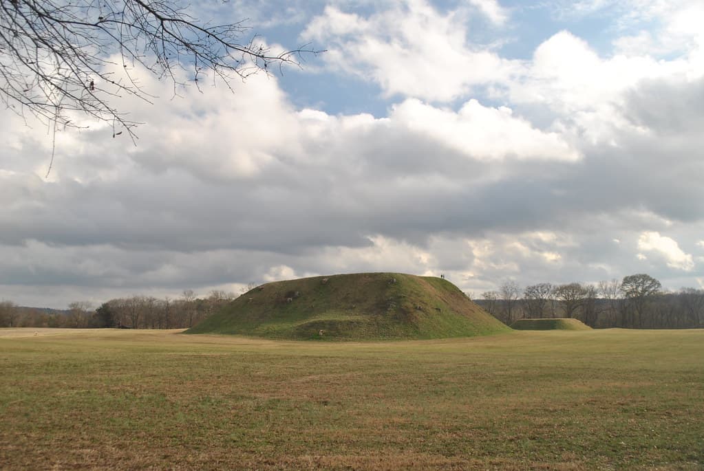
Angel Mounds, Evansville, Indiana
Evansville, Indiana, United States
For 350 years, Angel Mounds was the center of a world. The Mississippian people who built this sacred city aligned their mounds with solstices, tracking celestial events...

Antelope and Buffalo Springs (Chickasaw National Recreation Area)
Sulphur, Oklahoma, United States
In the Arbuckle foothills of Oklahoma, five million gallons of pure water gush daily from the earth....

Antelope Canyon
Page, Arizona, United States
Deep within Navajo land, narrow sandstone passages open into chambers of flowing stone and cascading light....

Archaeological Site of Palaepaphos
Kouklia, Cyprus, Cyprus
Palaepaphos was not a city with a temple. It was a temple that grew into a city....

As Nieves Latte Stone Quarry
Songsong / Sinapalo area, Rota, Northern Mariana Islands, Songsong / Sinapalo area, Rota, Northern Mariana Islands, United States
At As Nieves on Rota, nine massive latte shafts and seven capstones sit exactly where their carvers left them, mid-quarry, for reasons no source can confirm....

Ayers Rock (Uluru)
Macdonnell Region, Australia
Uluru rises 348 meters from the red desert of central Australia—a sandstone monolith that changes color with the light, from grey to orange to deep blood-red....
Aztalan Mounds, Wisconsin
Lake Mills, Wisconsin, United States
On the banks of the Crawfish River, platform mounds rise from prairie grass where they have stood for a millennium....

Baiame Cave
Milbrodale / Singleton, New South Wales, Milbrodale / Singleton, New South Wales, Australia
On a sandstone escarpment above Bulga Creek in the Hunter Valley, a painted figure with outstretched arms spanning roughly five metres represents the creator being known...

Bandelier National Monument
Sandoval County, New Mexico, United States
In a volcanic canyon carved by centuries of water and wind, the Ancestral Puebloans built homes into the soft tuff cliffs, dug kivas into the earth, and left petroglyphs...

Basilica Maria Loreto, St. Andra
St. Andrä im Lavanttal, Carinthia, Austria
Rising from the Lavanttal valley in southeastern Austria, the Basilica Maria Loreto holds a replica of the Holy House of Nazareth and its Black Madonna....

Basilica of Maria Loretto in Burgenland
Loretto, Burgenland, Austria
In the eastern Austrian lowlands, a village of five hundred souls receives one hundred thousand pilgrims annually....

Basilica of Our Lady of San Juan del Valle, San Juan, Texas
San Juan, Texas, United States
In the Rio Grande Valley of South Texas, over one million pilgrims journey each year to venerate a small statue of the Virgin Mary that survived a devastating 1970 plane...

Basilica of the National Shrine of the Assumption of the Blessed Virgin Mary, Baltimore, Maryland
Baltimore, Maryland, United States
In downtown Baltimore stands the Mother Church of Roman Catholicism in the United States, the first cathedral built in the new nation after its founding....

Basilica of the Virgin Mary, Mariazell
Mariazell, Steiermark, Austria
Set among the forested peaks of the Styrian Alps, the Basilica of the Virgin Mary in Mariazell has drawn pilgrims from across Central Europe for nearly nine hundred years....
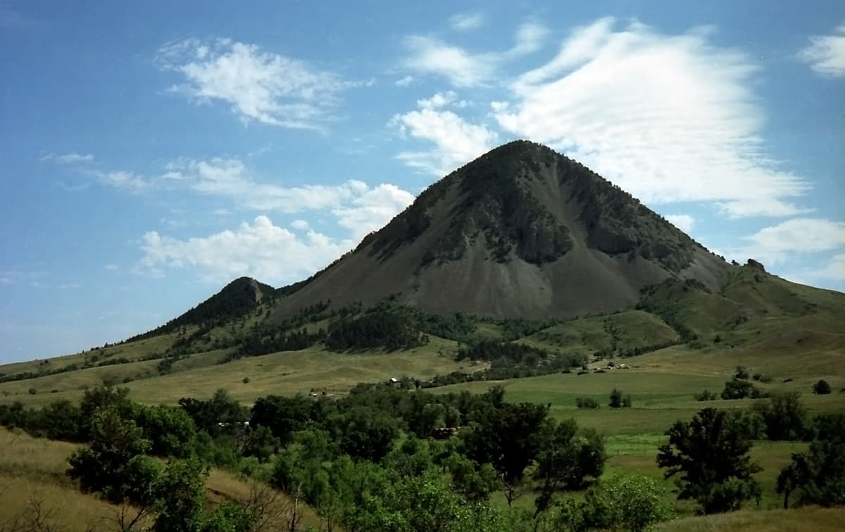
Bear Butte, South Dakota
Sturgis, South Dakota, United States
Rising alone from the South Dakota plains, Bear Butte has drawn seekers for ten thousand years. For the Lakota, it is their most sacred altar....

Big Horn Medicine Wheel, Wyoming
Big Horn County, Wyoming, United States
At nearly 10,000 feet in Wyoming's Bighorn Mountains, stones form a wheel 80 feet across, with 28 spokes radiating toward the sky. No one knows who built it....
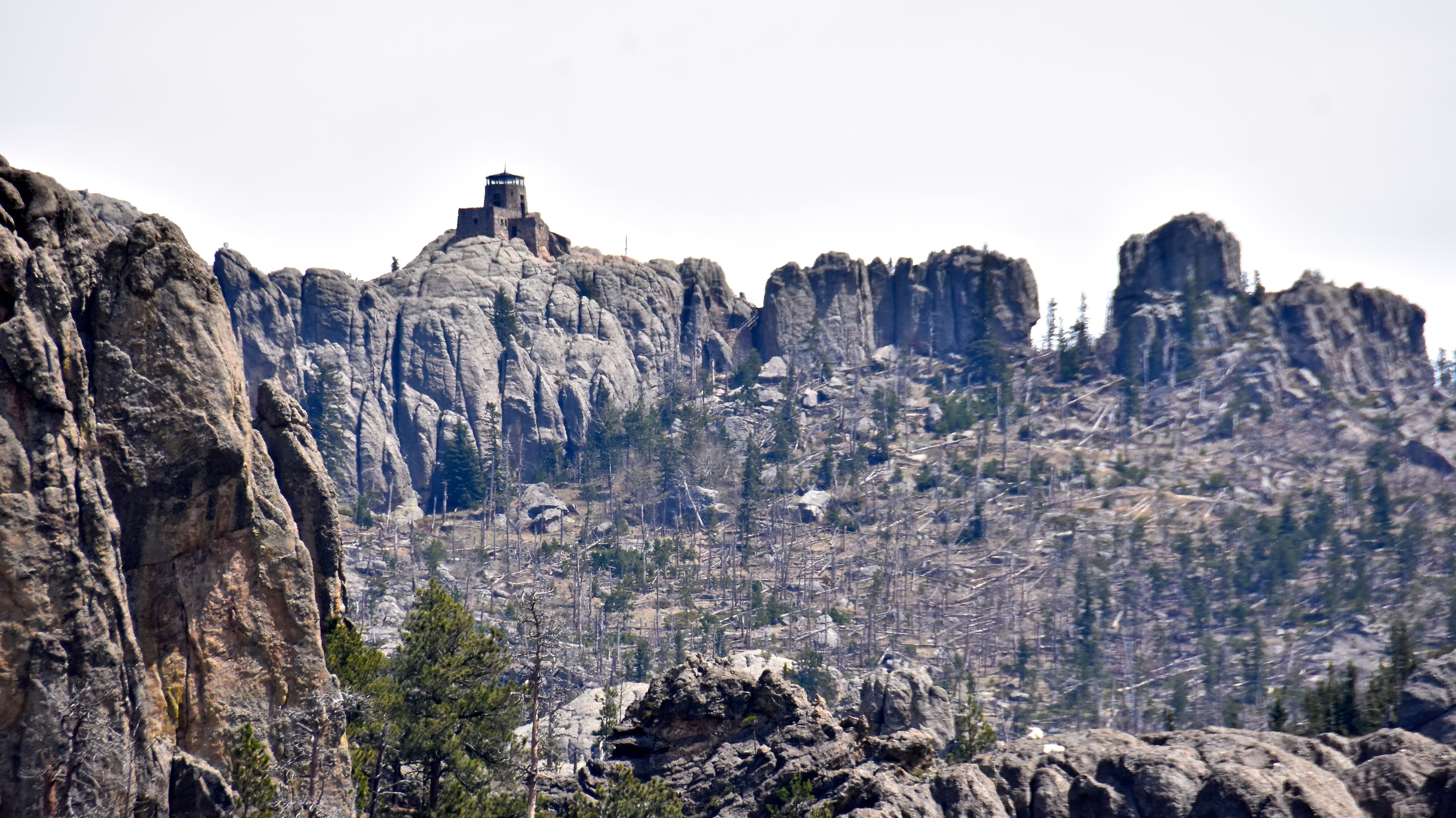
Black Elk Peak, South Dakota
Custer, South Dakota, United States
Rising as the highest point in the Black Hills, Black Elk Peak stands at the center of the world in Lakota cosmology....

Black Madonna of Częstochowa (Eureka, MO)
Eureka, Missouri, United States
Hidden on a wooded hillside in the Missouri Ozarks, the Black Madonna Shrine is the life's work of Brother Bronislaus Luszcz, a Polish Franciscan who spent 23 years...

Black Madonna of Kaltenleutgeben
Kaltenleutgeben, Lower Austria, Austria
In this baroque church south of Vienna, a copy of the famous Altotting Black Madonna has drawn pilgrims since 1712....

Black Madonna of Langenzersdorf
Langenzersdorf, Lower Austria, Austria
Since 1708, this copy of the famous Einsiedeln Black Madonna has kept vigil in St....

Black Madonna of Lavanttal
Sankt Andrä, Carinthia, Austria
In the Carinthian town of St. Andra, within a baroque basilica modeled after Italy's Holy House of Loreto, a Black Madonna has drawn pilgrims for nearly four centuries....

Black Madonna of Loretto Burgenland
Loretto, Burgenland, Austria
In the Austrian village that took its name from Loreto, a 1644 replica of the famous Black Madonna has outlasted the Italian original....

Black Madonna of Maria Loretto Peninsula
Klagenfurt, Carinthia, Austria
On a peninsula reaching into Lake Woerthersee, this 17th-century chapel replicates the Holy House of Loreto in Italy....

Black Mountain
Cook Shire, Queensland, Australia
South of Cooktown in far north Queensland, a pile of massive black granite boulders rises from the tropical landscape....

Blanca Peak, Colorado
Fort Garland, Colorado, United States
Blanca Peak rises in Colorado's Sangre de Cristo Range as one of the four most sacred mountains in Navajo religion....
Blue Lake, New Mexico
Taos County, New Mexico, United States
High in the Sangre de Cristo Mountains of northern New Mexico, an alpine lake sits at 11,300 feet, closed to all but the people who emerged from its waters....

Blythe Intaglios
Blythe, California, United States
In the Colorado Desert, fifteen miles north of Blythe, six colossal figures lie etched into the earth....

Bryce Canyon National Park
Bryce Canyon City, Utah, United States
At the edge of Utah's high plateau, thousands of stone spires rise from natural amphitheaters in formations found nowhere else on Earth....

Bunjil's Shelter
Stawell / Black Range, Victoria, Stawell / Black Range, Victoria, Australia
In a shallow shelter beneath a granite boulder in Victoria's Black Range, a small ochre painting shows Bunjil, the creator-being of south-eastern Australia, flanked by two...

Burrungkuy (Nourlangie)
Jabiru / Burrungkuy region, Northern Territory, Jabiru / Burrungkuy region, Northern Territory, Australia
Burrungkuy (Nourlangie) rises from the Kakadu floodplain as a rock art complex occupied for more than 6,000 years, its Anbangbang gallery holding an x-ray-style painting...
Caguana Ceremonial Indigenous Heritage Site
Utuado, Puerto Rico, United States
In the mountain heart of Puerto Rico, thirteen stone-lined courts stand beneath the sacred Cemi Mountain, where the Taino believed gods made their home....
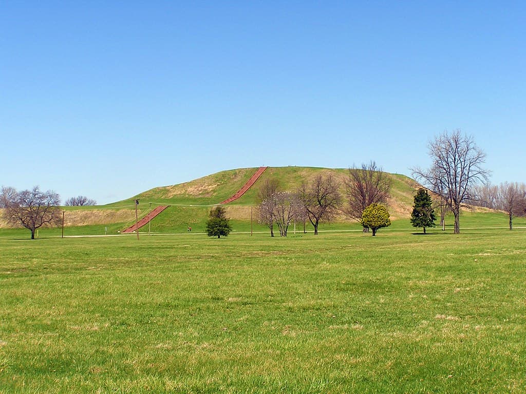
Cahokia Mounds, Collinsville, Illinois
Collinsville, Illinois, United States
Eight miles from downtown St. Louis, across the Mississippi, 70 earthen mounds mark what was once the largest city north of Mexico....
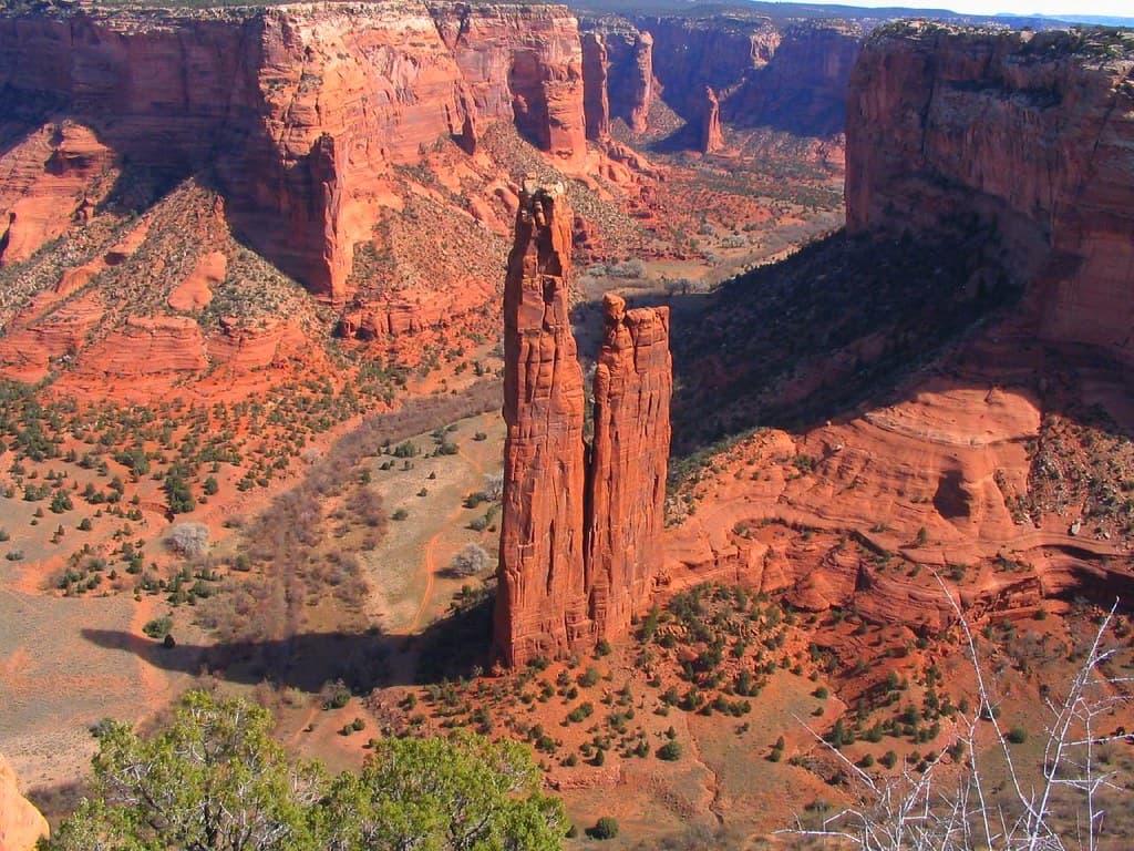
Canyon de Chelly, Arizona
Chinle Agency, Arizona, United States
Canyon de Chelly rises 1,000 feet above a valley where Navajo families still farm, herd sheep, and practice traditions their ancestors carried here three centuries ago....

Capitan Mountains, New Mexico
Lincoln County, New Mexico, United States
The Capitan Mountains rise from the desert of south-central New Mexico in an unusual east-west ridge, climbing from Chihuahuan sagebrush to spruce-fir forest across 4,500...

Carnarvon Gorge Art Gallery
Carnarvon Gorge, Queensland, Carnarvon Gorge, Queensland, Australia
Deep in a sandstone gorge in central Queensland, a sheltered rock wall carries roughly 2,000 stencils, engravings and paintings built up over thousands of years....
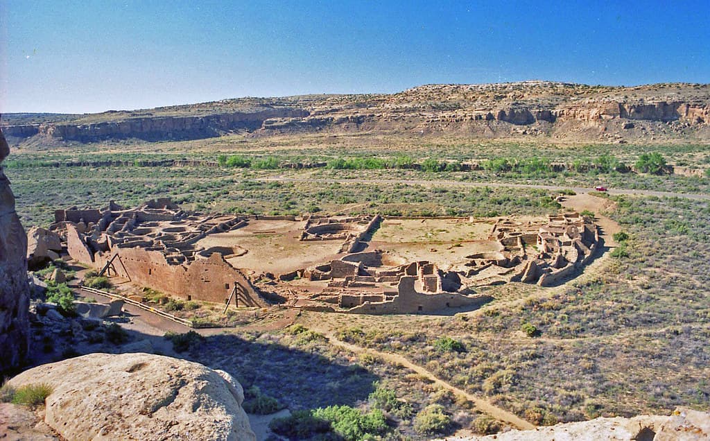
Chaco Canyon, New Mexico
San Juan County, New Mexico, United States
In the high desert of New Mexico, the ruins of Chaco Canyon stand as testimony to a civilization that achieved extraordinary things....

Chambers Pillar Historical Reserve
Hugh / Alice Springs region, Northern Territory, Hugh / Alice Springs region, Northern Territory, Australia
Fifty metres of red sandstone rise abruptly from the flat desert plain south of Alice Springs....
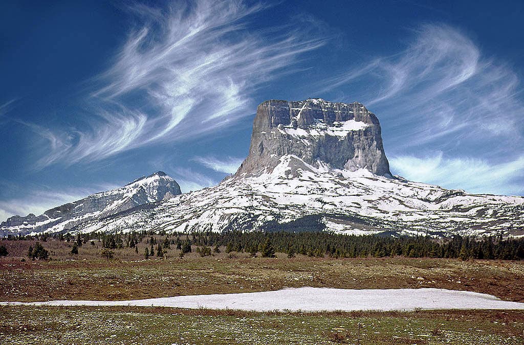
Chief Mountain (Ninaistakis), Glacier County, Montana
Babb, Montana, United States
Chief Mountain rises alone at the edge of the Rocky Mountains, a solitary peak standing sentinel where the plains meet the sky....

Church of St. George, Georgenberg
Stans, Tirol, Austria
Perched on a rocky outcrop rising one hundred meters above the Stallental valley in the Austrian Alps, St. Georgenberg is the oldest extant monastery in Tyrol....

City on the Magdalensberg
Magdalensberg, Kärnten, Austria
Rising above the Zollfeld plain in southern Carinthia, the Magdalensberg holds the remains of what was likely the royal capital of the Celtic Kingdom of Noricum and,...

Crestone
Crestone, Colorado, United States
Crestone rises against the Sangre de Cristo Mountains as North America's most remarkable interfaith sanctuary....

Crystal River Mounds, Florida
Crystal River, Florida, United States
On Florida's Gulf Coast, six mounds rise above the Crystal River where, for sixteen centuries, peoples gathered to bury their dead with copper from the Great Lakes and...

Effigy Indian Mound, Iowa
Allamakee County, Iowa, United States
High above the Mississippi River, on bluffs overlooking one of America's great waterways, ancestors built the earth into the shapes of bears, birds, and water spirits....

Emerald Mound, Stanton, Mississippi
Stanton, Mississippi, United States
Rising from the Mississippi landscape, Emerald Mound covers eight acres and stands as the second-largest Mississippian ceremonial mound in the United States, surpassed...

Enchanted Rock, Texas
Fredericksburg, Texas, United States
Rising from the Texas Hill Country, this massive pink granite dome has drawn humans for over ten thousand years....
Etowah mounds, Georgia
Cartersville, Georgia, United States
In the rolling hills of northwest Georgia, six earthen mounds rise above the Etowah River where the Mississippian people built one of the most powerful chiefdoms in...

Garden of the Gods, Colorado
Colorado Springs, Colorado, United States
Garden of the Gods rises from the Colorado plains as one of America's most sacred landscapes, a place where the Ute people believe humanity was created....
Showing 1-48 of 181 sites
Key questions
United States sacred-site questions
- What sacred sites can I explore in United States?
- Pilgrim Map lists sacred places in United States across living worship sites, heritage landmarks, pilgrimage destinations, and culturally significant landscapes. The current guide lists 132 sites organized by region, tradition, and site type.
- Which traditions are represented in United States?
- The most represented traditions include Indigenous, Christianity, Multi-faith, Ancient Greek and Roman, Islam, Celtic and Prehistoric.
- How should I plan a sacred-site visit in United States?
- Start with regional clusters, compare nearby places on the map, then open individual site pages for coordinates, etiquette, and sacred context where available.
- Can I view United States sacred sites on a map?
- Yes. Switch to map view to compare geographic clusters, then open individual site pages for coordinates, visiting context, and related places.