Tula Archaeological Zone
A Toltec capital where warrior columns, serpent walls, and plazas joined sacred and civic power
Understand sacred places, explore living traditions, and learn how to engage respectfully with Pilgrim Map.
Access has not been verified. Check current local guidance before planning a visit.
Tula de Allende, Hidalgo, Mexico
Read the sources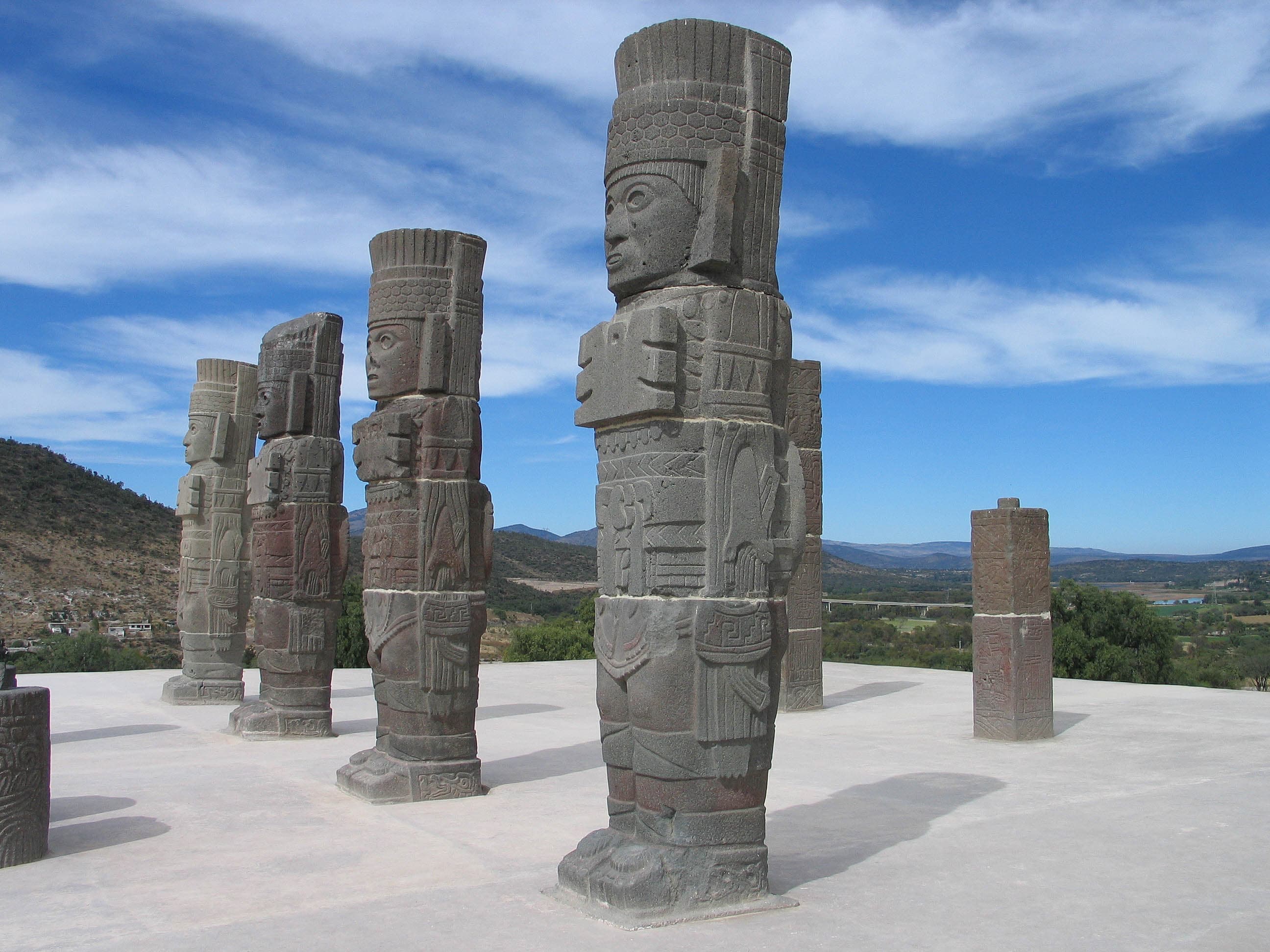
The four Atlantes on Pyramid B at Tula Archaeological Zone in Hidalgo, Mexico. Image source · CC BY-SA 3.0
Visit essentials
A quick read before you go
- Duration
- Plan roughly half a day if you want to read the interpretation and study the major structures…
- Access
- Use the signed archaeological-zone entrance at Boulevard Tula y Iturbe km 2.5; INAH also…
Overview
Above the broad plaza of Tula Grande, four monumental figures stand on Pyramid B. Known today as the Atlantes, they wear butterfly-shaped pectorals, headdresses, darts, an atlatl, and other signs of armed rank. INAH considers it likely that these carved figures once supported a roof. They are not solitary idols detached from their setting: pilasters, serpent columns, processional reliefs, the Coatepantli, and nearby columned spaces belonged to a larger ceremonial and political composition.
The archaeological zone preserves the public center of Tollan-Xicocotitlan, a city that grew from the earlier settlement called Tula Chico and reached its greatest scale during the Tollan phase, approximately 900 to 1150 CE. Temples, palaces, ballcourts, altars, residential districts, workshops, streets, and exchange areas formed a socially diverse metropolis. Its sacred geography therefore cannot be reduced to a single pyramid or deity. Public authority, warfare, offerings, celestial symbolism, trade, and urban life were materially connected.
INAH associates Pyramid B and parts of its imagery with Quetzalcóatl as Tlahuizcalpantecuhtli, the Morning Star. Later traditions also remember Tula as the city of Ce Ácatl Topiltzin Quetzalcóatl, where history and legend intermingle. The custodial source draws a firm boundary: there is no archaeological basis for presenting the famous exile narrative as a proven event at this particular city.
Respecting Tula means allowing the monuments, later memory, and scholarly uncertainty to remain in dialogue without forcing them into one seamless story.
Why this place is sacred
The ceremonial center was planned as more than a collection of impressive objects. A central plaza larger than ten thousand square metres is framed by platforms and monumental buildings. Pyramid B, the Burned Palace, the columned vestibule, Pyramid C, Ballcourt 2, a tzompantli, and the central altar occupy related positions. Movement through these spaces made authority visible, while reliefs of armed figures, animals, serpents, and composite beings gave that authority a sacred language.
Quetzalcóatl and Venus are important to this language, but identifications differ in certainty. INAH names Pyramid B the Temple of Tlahuizcalpantecuhtli and interprets cross-sectioned shell forms and other imagery in relation to Venus. Some individual relief figures are described only as possible representations. The distinction between a strong contextual interpretation and a tentative identification should remain visible.
Later Nahua traditions treated Tollan as a place of exemplary skill, order, and legitimate rule.
The place is also physically fragile. INAH conservation research documents soft volcanic stone, surviving stucco and color, fractures, water, wind, pollution, urban growth, and earlier restoration materials as pressures on the reliefs. Sacred attention here includes restraint: protected surfaces are evidence, and touching or climbing can destroy information that no reconstruction can restore.
The monumental core of a Toltec capital, combining religious, political, administrative, exchange, ballgame, and public ceremonial functions within a planned urban landscape.
Urban growth began around Tula Chico in the seventh and eighth centuries. Tula Grande flourished during the Early Postclassic before the Toltec state's twelfth-century disintegration. Systematic excavation began under Jorge R. Acosta in 1940, followed by continuing INAH research, conservation, and public interpretation.
Experience and orientation
Begin with the city rather than its icon. Near the entrance, residential remains introduce the neighborhoods in which most inhabitants lived. As the route reaches the monumental precinct, the scale changes: terraces, paved spaces, platforms, ballcourts, and columned halls reveal how carefully public movement was organized.
At Pyramid B, notice that the Atlantes are architectural figures as well as carved bodies. Their equipment and clothing carry martial and status meanings; their probable structural role would have placed them within a roofed temple rather than exposed exactly as they appear today. Nearby pilasters show priests or prominent figures, and serpent-shaped columns once marked an entrance. The Coatepantli's reliefs of serpents and partly skeletal human figures require sober attention, not dramatic posing.
The Burned Palace is another place where names can mislead. INAH explains that despite its conventional title and evidence of fire, the building may have served public-administrative or market functions rather than domestic palace life. Its three columned rooms, internal courts, benches, and reliefs show an institution whose exact activities remain open to study.
The semi-arid plateau is exposed to sun, wind, sudden rain, and temperature changes. These conditions affect visitors and monuments alike. Barriers or access routes may change when conservation requires it. Treat a closed stair or protected relief as part of the site's care, not as an obstacle to a complete experience.
Use the INAH entrance and site museum at Boulevard Tula y Iturbe. The visitor coordinate marks this entrance; the monumental core lies roughly one kilometre farther inside the protected zone.
Context and lineage
Ceramic research complicates any simple story of an abrupt Toltec beginning. INAH scholarship places meaningful urban growth around 700 to 750 CE and treats Mazapa material as part of the city's development rather than merely a narrow transition. Tula Chico occupied about three square kilometres along the river before the creation of the later monumental center.
Tula Grande emerged in the tenth century with an orientation that INAH connects to stellar observation. At maximum development, official estimates for the broader city range from about sixteen to eighteen square kilometres depending on the study and phase described. Residential compounds, elite and common households, temples, production areas, streets, plazas, and exchange spaces formed a complex urban organism.
INAH describes Tula's strategic role in controlling resources including turquoise and its influence from the Bajío and Gulf regions toward the Yucatán Peninsula and parts of Central America.
The Toltec state's disintegration in the twelfth century is not explained by one settled cause. Internal disputes, incursions, population pressure, migration, and changing regional conditions all appear in INAH accounts. Later Mexica activity left additional structures at Tula, and later Nahua peoples remembered Tollan as an ancestral source of culture and authority.
Jorge R. Acosta led thirteen systematic field seasons from 1940 to 1960, exposing many monuments now seen by visitors. Subsequent projects under Centro INAH Hidalgo refined the city's chronology and extent. Current conservation includes close material study and three-dimensional recording of reliefs whose soft stone and surviving finishes are vulnerable.
The zone holds Toltec urban and ceremonial history, later Mexica interventions, and later Nahua memory of Tollan. Today it is protected by INAH as archaeological heritage of Mexico; this entry does not assign exclusive modern ritual authority without evidence.
Ce Ácatl Topiltzin Quetzalcóatl
Later Nahua tradition holds that Ce Ácatl Topiltzin Quetzalcóatl was a king-priest and culture hero associated with Tollan; INAH emphasizes that history and legend intermingle and that the exile episode is not archaeologically proven at this site.
Jorge R. Acosta
Archaeologist who directed thirteen major seasons of investigation from 1940 to 1960; the site museum bears his name.
Guadalupe Mastache and Robert Cobean
Archaeologists whose later INAH-supervised research substantially advanced understanding of Tula's urban scale, chronology, and material culture.
Traditions and practice
Historical practices may have included offerings at altars, ceremonies before ballgames, processions of warriors or priests, state rites associated with Quetzalcóatl and Venus, and display of human heads at a tzompantli. Each claim belongs to a particular structure and level of evidence; the monuments do not provide a complete liturgy.
For a general visitor, appropriate contemporary practice is careful observation under INAH guidance, learning from the museum and signs, and protecting the archaeological fabric. Public opening does not grant permission to conduct private rites on ancient structures.
Pause in the central plaza and trace the relationships among Pyramid B, the columned buildings, ballcourt, central altar, and Pyramid C. Consider how sacred authority was organized through architecture, movement, images, and public gathering rather than treating the Atlantes as detached curiosities.
Toltec ceremonial tradition
ActiveTula Grande joined temples, offerings, ballcourts, armed processions, celestial symbolism, and public authority in a planned ceremonial-political center.
Later Nahua memory and political tradition
ActiveLater accounts remembered Tollan and Ce Ácatl Topiltzin Quetzalcóatl as exemplary sources of culture and legitimacy, while the archaeological identification of particular legendary events remains uncertain.
Perspectives and open questions
Tula can be read as a sacred political center, a heterogeneous city, a remembered Tollan, a landscape of exchange, and a fragile conservation site. These readings are strongest when the evidence and uncertainty of each remain visible.
Scholarly perspective
Archaeology supports phased growth from Tula Chico into Tula Grande, a large Early Postclassic capital, and a planned monumental core linked to public ritual and government. Ceramic chronology, urban survey, architecture, reliefs, human remains, and exchange materials refine that picture. The precise use of every building, meaning of every figure, mechanisms of regional influence, and causes of collapse remain open in varying degrees.
Living and traditional perspectives
Later Nahua tradition holds that Tollan and Quetzalcóatl exemplified civilized skill, sacred rulership, and political legitimacy. These accounts are understood as evidence of how the place and idea of Tollan were remembered, but they should not be collapsed into a literal archaeological chronology.
Alternative interpretations
Claims that the Atlantes are extraterrestrials, machines, or keys to an undocumented energy initiation are not supported by INAH research and are not presented as fact.
Open questions
Uncertainties include the exact dedication of several buildings, the original appearance of roofed spaces, the identity of some relief figures, how later Tollan narratives map onto archaeological Tula, the balance among trade, emulation, migration, and conflict in regional influence, and the reasons the Toltec state disintegrated.
Plan your visit
Access and arrival
Use the signed archaeological-zone entrance at Boulevard Tula y Iturbe km 2.5; INAH also describes local collective transport from central Tula in the direction of Actopan, Iturbe, or Santa Ana. | Difficulty: Outdoor walking over exposed and sometimes uneven surfaces, with stairs at some monuments. INAH lists accessibility services, but the exact accessible route and assistance should be confirmed directly.
| Time to summit: There is no mountain summit; allow time to walk from the entrance and museum area to the monumental core roughly one kilometre inside the zone.
Tula de Allende has transport and visitor services. Confirm independent arrangements; no commercial recommendation is implied.
Respectful visit
Wear sturdy footwear and protection from strong sun, wind, and rain. Clothing should support safe walking on exposed, sometimes uneven archaeological routes.
Ordinary personal photography is subject to current INAH and posted site rules. | Flash is prohibited. Professional equipment, drones, and commercial photography may require authorization. Do not cross barriers or stage sacrificial, martial, or pseudo-ritual scenes.
Altars, reliefs, and archaeological remains are interpreted in relation to historical offerings and state ceremonies. | Do not leave coins, flowers, food, liquids, incense, or other objects on the monuments.
INAH currently prohibits smoking, food, pets, and flash. Access to particular monuments may be restricted for conservation.
Do not leave offerings, burn incense, climb closed architecture, touch reliefs, imitate sacrifice, or present a personal ceremony as Toltec continuity. Avoid sensational descriptions of human remains and warfare.
Current practical details
Address
Boulevard Tula y Iturbe km 2.5, 16 de Enero (El Tesoro), El Salitre, 42800 Tula de Allende, Hgo., México
Phone
Hours
Hours, fees, and access can change — verify on the official source before you travel. Practical details last checked Aug 2026.
Location
Map loads as you approach this section.
Pilgrim reflections
A portrait of encounter, not a score
Pilgrims describe what they felt, how present they could become, and whether the place would shape a journey. There are no stars and no ranking of traditions.
No reviewed reflections yet
The first pilgrims can help describe the character of being here.
Share a reflection
Available after an account-backed “Been there.” Every reflection is reviewed before publication.
Nearby sacred places
Explore other sacred places in the region. Proximity does not establish access or travel time; check each place’s guidance.

Pyramid of the Moon, Teotihuacán
San Juan Teotihuacan, Mexico, Mexico
65.7 km away

Pyramid of the Sun, Teotihuacán
San Juan Teotihuacan, Mexico, Mexico
66.0 km away

Teotihuacan
Teotihuacán, Mexico, Mexico
66.6 km away
Basilica of Our Lady of Remedies, Naucalpan de Juarez
Naucalpan de Juárez, Mexico, Mexico
67.4 km away
References
Sources consulted for this page. Source categories describe the publication, not a guarantee that every claim is verified. Traditional accounts and outside interpretations may differ.
- 01Zona Arqueológica y Museo de sitio de Tula — Instituto Nacional de Antropología e HistoriaofficialPrimary custodial source for identity, chronology, access, present visitor information, trade and political reach, and the warning that the Quetzalcóatl exile story cannot be fixed at archaeological Tula as established history. Updated 17 February 2026.
- 02Tula — Lugares INAH, Instituto Nacional de Antropología e HistoriaofficialDetailed official interpretation of Tula Chico, Tula Grande, urban organization, Atlantes, Pyramid B, Coatepantli, Burned Palace, ballcourts, central plaza, Quetzalcóatl associations, museum, services, and current visitor rules.
- 03Una mirada a su compleja traza urbana — Lugares INAH, Instituto Nacional de Antropología e HistoriaofficialOfficial account of the monumental precinct, landscape setting between the Tula and Rosas rivers, and the city's maximum urban extent during the Tollan phase.
- 04El museo de un lugar excepcional — Luis Manuel Gamboa Cabezas, Centro INAH HidalgoofficialOfficial history and scope of the Jorge R. Acosta Site Museum and the archaeological projects represented in its collections.
- 05Documentación tridimensional para la conservación de los relieves de Tula, Hidalgo — Coordinación Nacional de Conservación del Patrimonio Cultural, INAHacademicPeer-reviewed INAH conservation study documenting the public monumental complex, ritual and martial reliefs, vulnerable volcanic stone, environmental and urban pressures, and non-contact 3D recording.
- 06Tula-Mazapa entre Coyotlatelco y Tollan — Osvaldo José Sterpone CanutoacademicINAH archaeological research refining the ceramic chronology and identifying urban growth around 700-750 CE rather than a simple abrupt transition into the Tollan phase.
- 07Telamones Tula — LuidgeracademicExact-site photograph of the Atlantes made on 25 December 2004 and released by its creator under CC BY-SA 3.0.
- 08Tula archaeological site (Q568672) — Wikidata contributorsacademicStructured identity, distinction from the modern city, Commons category, and monumental-core coordinates used only as corroboration.
Share a photo
Help visitors recognize Tula Archaeological Zone. Every submission is reviewed before publication.