Capitan Mountains, New Mexico
Where Mountain Spirits dwell in a wild granite range that fire and time have not tamed
Lincoln County, New Mexico, United States

Plan this visit
Practical context before you go
A summit attempt via the Capitan Peak Trail requires a full day: 12.2 miles round trip with 3,740 feet of elevation gain, typically 7.5 to 8.5 hours. Allow more time if trails are overgrown. Two to three days of backcountry camping allows exploration of the Summit Trail along the main ridgeline. Extended trips of 3 to 5 days cover the full 15.5-mile Summit Trail and connecting routes.
The primary access is from the town of Capitan via Forest Road 130 to the Capitan Peak Trailhead on the northeast side of the range. High-clearance or four-wheel-drive vehicles are recommended, as the forest road has significant rocks and ruts. Alternative access points exist on other sides of the range via various forest roads, all of which require checking current conditions. No entrance fee. Mobile phone signal is unreliable within the wilderness and on the forest roads approaching the trailheads. The town of Capitan, approximately 10 miles from the trailhead, is the nearest point with reliable service. Contact the Smokey Bear Ranger District at 575-257-4095 for current road conditions, trail status, and fire restrictions.
The Capitan Mountains require both wilderness preparedness and cultural respect. The range is sacred to the Mescalero Apache and lies within their ancestral homeland. Do not disturb cultural artifacts or ceremonial materials. Practice Leave No Trace. Come prepared for genuine backcountry conditions with poor trails, no water, and large wildlife.
At a glance
- Coordinates
- 33.6067, -105.3636
- Type
- Sacred Mountain
- Suggested duration
- A summit attempt via the Capitan Peak Trail requires a full day: 12.2 miles round trip with 3,740 feet of elevation gain, typically 7.5 to 8.5 hours. Allow more time if trails are overgrown. Two to three days of backcountry camping allows exploration of the Summit Trail along the main ridgeline. Extended trips of 3 to 5 days cover the full 15.5-mile Summit Trail and connecting routes.
- Access
- The primary access is from the town of Capitan via Forest Road 130 to the Capitan Peak Trailhead on the northeast side of the range. High-clearance or four-wheel-drive vehicles are recommended, as the forest road has significant rocks and ruts. Alternative access points exist on other sides of the range via various forest roads, all of which require checking current conditions. No entrance fee. Mobile phone signal is unreliable within the wilderness and on the forest roads approaching the trailheads. The town of Capitan, approximately 10 miles from the trailhead, is the nearest point with reliable service. Contact the Smokey Bear Ranger District at 575-257-4095 for current road conditions, trail status, and fire restrictions.
Pilgrim tips
- Full backcountry gear. Sturdy boots for rough, rocky terrain and overgrown trail sections. Long pants for brushy stretches. Layers for the 4,500-foot elevation range traversed on a summit hike. Rain gear for afternoon thunderstorms. Sun protection on exposed ridgelines.
- Photography of natural scenery is permitted throughout the national forest and wilderness. Do not photograph cultural artifacts, ceremonial materials, or people engaged in cultural practices if encountered.
- The Capitan Mountains are genuine wilderness with poorly maintained trails, no reliable water sources, and resident black bears and mountain lions. Navigation skills are essential, as trail markers are unreliable and sections are overgrown. Summer thunderstorms bring lightning danger on exposed ridgelines. If you encounter any cultural artifacts or ceremonial materials, do not disturb them. Fire danger can be extreme in dry seasons. Check with the Smokey Bear Ranger District before your visit.
Overview
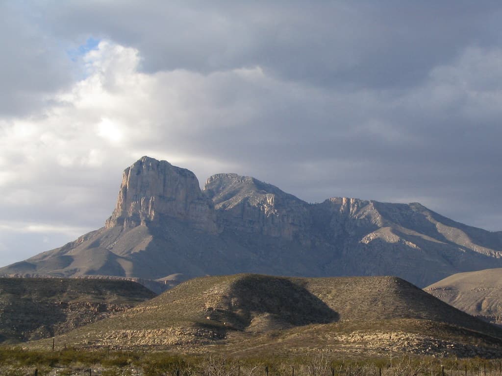
The Capitan Mountains rise from the desert of south-central New Mexico in an unusual east-west ridge, climbing from Chihuahuan sagebrush to spruce-fir forest across 4,500 feet of elevation. Sacred to the Mescalero Apache as a dwelling place of the Mountain Spirits, the range holds 34,000 acres of designated wilderness where trails fade into brush and solitude is not an aspiration but a given. This is also the landscape where a burned bear cub was rescued in 1950, becoming the living symbol of Smokey Bear.
Certain places resist visitation by their very nature. The Capitan Mountains do not invite. They require. The trails are faint, often overgrown. The access roads demand high clearance and patience. The nearest services are miles away, and the wilderness itself offers nothing in the way of comfort. Those who come anyway discover a landscape of uncommon intensity.
For the Mescalero Apache, whose homeland surrounds these mountains, this intensity has a name: Ga'an. The Mountain Spirits dwell in the peaks, powerful beings who mediate between the people and the Creator. When Mescalero prayers are spoken, they are directed at the mountains, which are understood to catch them. The mountain environment provides medicinal plants necessary for ceremony. In Mescalero spiritual ecology, the health of the mountain and the health of the people are not separate conditions but the same condition experienced from different vantage points.
The Capitan range carries another story as well. In May 1950, a fire burned through 17,000 acres of these mountains. A badly burned black bear cub was found clinging to a charred tree, rescued, and rehabilitated. He became the living Smokey Bear, one of the most recognized symbols of American conservation. The story of destruction and rescue, of fire as both devastation and renewal, resonates with the Apache understanding of these mountains as places where power concentrates, where what is broken can be healed.
The wilderness designation, established in 1980, protects 34,000 acres of this granite intrusion. The protection is less active management than deliberate withdrawal. The trails receive minimal maintenance. The forest grows back on its own terms. The mountain keeps its character precisely because so few people come.
Context and lineage
In Mescalero Apache understanding, the Creator brought the Apache to life on White Mountain, Sierra Blanca, and the sacred mountains of the homeland became dwelling places of the Mountain Spirits. The Capitan Mountains, rising from the desert within the Apache homeland, are part of this sacred landscape where the Ga'an concentrate their power. Specific creation narratives relating to the Capitan range are kept private by the Mescalero community.
The mountains carry a more recent origin story as well. In May 1950, fire burned through 17,000 acres of the Capitan range. Firefighters discovered a badly burned black bear cub clinging to a charred tree, his paws and hind legs singed. Nursed back to health, he was sent to the National Zoo in Washington, D.C., where he lived until 1976 as the living embodiment of the Smokey Bear campaign. His body was returned to Capitan and buried at what is now Smokey Bear Historical Park. The story of a small creature surviving catastrophe in sacred mountains became, without anyone quite intending it, a parable about resilience and the relationship between humans and wild places.
The Jornada Mogollon culture inhabited the Lincoln County region from approximately 200 to 1450 CE, followed by Mescalero and Lipan Apache occupation from around 1300 onward. The Apache relationship with the mountains persisted through colonial contact, the turbulent Lincoln County War period, and the establishment of federal forest management. The 1980 wilderness designation preserved the range's wild character, though primarily for ecological rather than cultural reasons. The Mescalero Apache Reservation, approximately 30 miles southwest, maintains the community's proximity to the mountain homeland.
Ga'an (Mountain Spirits)
spiritual beings
Powerful spiritual beings who dwell in the mountains of the Mescalero homeland, acting as intermediaries between the people and the Creator. In ceremony, masked dancers embody the Ga'an, channeling the mountains' spiritual power through human bodies.
Smokey Bear
conservation symbol
A black bear cub rescued from the 1950 Capitan Gap Fire who became the living symbol of American wildfire prevention. Buried in Capitan, New Mexico, his story links the Capitan Mountains to the national conversation about fire, wilderness, and stewardship.
Martin W. Ball
scholar
Published peer-reviewed research documenting the central role of sacred mountains in Mescalero Apache religious identity, demonstrating that mountains are the primary source of spiritual revelation in Apache thought and that ecology and spirituality are co-dependent.
Why this place is sacred
The range is unusual in nearly every respect. Where most North American mountain ranges run north-south, the Capitans trend east-west, an elongated granite intrusion that cuts across the expected grain of the landscape. The effect is disorienting in the way that thin places often are. Approaching from any direction, the mountains present an unfamiliar profile, their silhouette unlike the ranges that surround them.
The ecological compression intensifies this quality. In the span of a few miles and 4,500 feet of vertical gain, the landscape transforms from Chihuahuan desert through pinon-juniper woodland, ponderosa pine forest, and mixed conifer into spruce-fir at the summit. Each transition feels abrupt, a threshold crossed rather than a gradient walked. The Mescalero Apache, who recognize the mountain environment as the source of medicinal plants necessary for ceremony, understand this ecological diversity as spiritual abundance. The mountain does not merely support life. It concentrates it.
The Mountain Spirits, the Ga'an, are the theological expression of this concentration. In Mescalero understanding, these powerful beings inhabit the mountains and act as intermediaries between the people and the Creator. During Ga'an ceremonies, masked and painted dancers embody the spirits in groups of five: a messenger and four dancers representing the cardinal directions. The choreography, performed at night to drumming and singing, channels the power of the mountains through human bodies. The mountains are the source.
Fire has shaped this landscape repeatedly, and the 1950 Capitan Gap Fire left scars still visible on the ridgelines. In Apache fire ecology, as in Western forest science, fire is not purely destructive but a mechanism of renewal. The bear cub rescued from the ashes of that fire became a symbol of this understanding, even as the Smokey Bear campaign paradoxically promoted fire suppression for decades. The mountains hold the contradiction without resolving it.
The Capitan Mountains served the Mescalero Apache as part of their sacred homeland, a landscape where Mountain Spirits dwell, where medicinal plants grow in the diversity of elevations, and where spiritual power concentrates. Mount Capitan is specifically identified as a Mescalero Apache sacred mountain. The Jornada Mogollon people inhabited the surrounding region from approximately 200 to 1450 CE, likely with their own connections to the mountain landscape, though the specific nature of those connections is not documented.
Apache presence in the Capitan Mountains extends back at least 700 years. The colonial period, the Lincoln County War of 1878, the establishment of the Lincoln National Forest in 1902, and the wilderness designation of 1980 represent successive layers of non-indigenous engagement with the landscape. Through all of this, the Mescalero Apache, now based on a reservation approximately 30 miles southwest, have maintained their cultural and spiritual connections to the broader mountain homeland.
Traditions and practice
The Mountain Spirit ceremony is among the most significant Mescalero religious practices. Masked and painted dancers, in groups of five, embody the power of the sacred mountains and the four cardinal directions. The choreography, performed at night to drumming and singing, channels the mountains' spiritual energy through human bodies to effect blessings and healings. The mountains themselves are the source of this power, and the medicinal plants gathered from their diverse ecological zones are necessary for the proper enactment of ceremony. Specific practices at the Capitan Mountains are kept private by the Mescalero community.
The Ga'an tradition remains actively practiced by the Mescalero Apache. The relationship between the tribe and its mountain homeland continues, sustained by cultural practices that have persisted through centuries of disruption. For non-Apache visitors, the Capitan Mountains offer no organized spiritual programs or ceremonies. The mountains' contemplative value lies entirely in their wilderness character.
Pay attention to the ecological transitions as you ascend. Each zone carries its own sound, its own quality of light, its own relationship between earth and sky. The desert floor hums with insects. The pine forest filters the wind into whispers. The spruce-fir zone near the summit holds a different silence, colder and more compressed.
Where the 1950 fire passed, the regrowth is visible decades later. Young trees grow among the ghosts of old ones. This is the landscape that produced Smokey Bear, and it teaches something about fire that the prevention campaign got wrong: fire is not the enemy of the forest but part of its life. The Apache have always known this. Stand in a burned clearing and watch how the mountain heals itself.
If you reach the summit ridge, look southwest toward Sierra Blanca, the most sacred of the Mescalero Apache mountains. The sightline between the two peaks is not accidental. Sacred geography works through connection, through the relationships between places, and from this vantage point you can see the web.
Mescalero Apache (Nde)
ActiveThe Capitan Mountains lie within the ancestral homeland of the Mescalero Apache, and Mount Capitan is identified as a Mescalero sacred mountain. Mountains throughout Apache territory are understood as dwelling places of the Mountain Spirits (Ga'an), sources of medicinal plants for ceremony, and places where spiritual power concentrates. Mescalero spiritual ecology makes no distinction between the health of the mountain environment and the health of ceremonial life.
The Mountain Spirit (Ga'an) ceremonial tradition remains one of the most vital aspects of Mescalero religious practice. Masked and painted dancers embody the power of the sacred mountains in groups of five, performing choreographed ceremonies at night that channel the mountains' spiritual energy for blessings and healings. Medicinal plants are collected from mountain environments across the Apache homeland. Specific practices at the Capitan Mountains are kept private.
Lipan Apache
HistoricalLipan Apache bands also inhabited the Capitan Mountains, closely related to the Mescalero and sharing overlapping territory in south-central New Mexico. The Lipan were eventually absorbed into the Mescalero Reservation community.
American conservation (Smokey Bear)
ActiveThe 1950 Capitan Gap Fire and the rescue of the bear cub who became the living Smokey Bear made the Capitan Mountains a touchstone of the American conservation movement. Smokey Bear Historical Park in the town of Capitan, where the bear is buried, draws visitors who connect the mountains to the broader national conversation about wildfire, forest stewardship, and humanity's relationship to wild places.
Smokey Bear Historical Park maintains a museum and the bear's gravesite. The Forest Service manages the Capitan Mountains Wilderness within the Lincoln National Forest. Fire management policy, which has shifted from total suppression toward managed fire, reflects evolving understanding of fire ecology in these mountains.
Experience and perspectives
The drive to the trailhead is the first test. Forest Road 130 climbs through rocks and ruts that discourage anything without high clearance. By the time you reach the trailhead, you have already separated from the ordinary world in a way that paved-road destinations cannot achieve.
The trail to Capitan Peak gains 3,740 feet over 6 miles, a demanding ascent through ecological zones that change faster than you might expect. The lower slopes bake in desert sun, pinon and juniper providing intermittent shade. Higher, ponderosa pines mark the transition into true mountain forest. The trail, such as it is, grows fainter with elevation, and sections where brush has reclaimed the path require careful navigation.
Wildlife moves through this landscape with the confidence of creatures accustomed to solitude. Black bears forage in the oak thickets. Elk drift through the meadows. Mountain lions, though rarely seen, leave tracks along the ridgelines. The 1950 fire created openings that the forest has been reclaiming for decades, and the mix of old growth and regrowth supports an unusual density of animal life.
From the summit ridge, the views open to encompass the Tularosa Basin to the south, Sierra Blanca to the southwest, and the rolling grasslands of Lincoln County in every direction. Sierra Blanca, the most sacred of the Mescalero Apache mountains, is clearly visible, and the sightline between the two peaks speaks to a sacred geography in which mountains relate to each other across distance, forming a network rather than a collection of isolated points.
Come prepared for genuine backcountry. Carry detailed maps and a compass or GPS, as trail markers are unreliable. Bring all water you will need, as no sources exist at the trailhead and stream crossings on the mountain are seasonal. Start early. Allow more time than the mileage suggests, as overgrown trail sections slow travel considerably. If you plan to camp, practice proper bear-country food storage.
The Capitan Mountains hold meaning within Mescalero Apache sacred geography, American conservation history, and the ecology of fire in Western forests. Each perspective offers a different reading of the same landscape, and the mountains are wild enough to hold all of them without any one dominating.
Geologists identify the Capitan Mountains as formed from a large elongated granite intrusion, one of the few east-west trending ranges in North America. The range spans five ecological life zones across 4,500 feet of elevation. Scholar Martin W. Ball's research documents the central role of sacred mountains in Mescalero Apache religious identity, demonstrating that Mescalero spiritual ecology makes no separation between ecological and spiritual health. Archaeological evidence documents Jornada Mogollon presence in the surrounding Lincoln County region from approximately 200 to 1450 CE, followed by Apache occupation from around 1300.
For the Mescalero Apache, the mountains of the homeland are dwelling places of the Ga'an, Mountain Spirits who mediate between the people and the Creator. Prayers are directed at the mountains, which catch them. The mountain environment provides medicinal plants essential for ceremony. The health of the mountain is the health of the people. Mount Capitan is specifically identified as a Mescalero sacred mountain, part of a sacred geography that connects the peaks of south-central New Mexico into a network of spiritual power.
The Capitan Mountains have not attracted significant New Age attention, likely due to their remote location and challenging access. The Smokey Bear story, however, has generated its own form of cultural reverence around themes of fire, survival, and humanity's relationship to wilderness. The bear cub's rescue from a burned landscape and his transformation into a conservation symbol carries mythic resonance that, while secular in origin, touches on patterns recognizable across sacred traditions: destruction, rescue, transformation, return.
The specific ceremonial role of the Capitan Mountains within the broader Mescalero Apache sacred geography, particularly how they relate to the four cardinal sacred mountains, is not publicly documented. Whether the Jornada Mogollon had sacred relationships with the range remains an open question. Whether the east-west orientation of the mountains, unique in North America, carries cosmological significance in Apache thought is unknown. The long-term ecological recovery from the 1950 fire, and how fire ecology intersects with the mountain's sacred character, continues to unfold.
Visit planning
The primary access is from the town of Capitan via Forest Road 130 to the Capitan Peak Trailhead on the northeast side of the range. High-clearance or four-wheel-drive vehicles are recommended, as the forest road has significant rocks and ruts. Alternative access points exist on other sides of the range via various forest roads, all of which require checking current conditions. No entrance fee. Mobile phone signal is unreliable within the wilderness and on the forest roads approaching the trailheads. The town of Capitan, approximately 10 miles from the trailhead, is the nearest point with reliable service. Contact the Smokey Bear Ranger District at 575-257-4095 for current road conditions, trail status, and fire restrictions.
The town of Capitan offers limited lodging and basic services. Smokey Bear Historical Park provides a museum, exhibits, and Smokey's gravesite. Ruidoso, approximately 20 miles south, provides more extensive visitor accommodations including hotels, restaurants, and outfitters. Dispersed camping is permitted within the national forest outside the wilderness boundary. Within the wilderness, backcountry camping follows Leave No Trace principles.
The Capitan Mountains require both wilderness preparedness and cultural respect. The range is sacred to the Mescalero Apache and lies within their ancestral homeland. Do not disturb cultural artifacts or ceremonial materials. Practice Leave No Trace. Come prepared for genuine backcountry conditions with poor trails, no water, and large wildlife.
Full backcountry gear. Sturdy boots for rough, rocky terrain and overgrown trail sections. Long pants for brushy stretches. Layers for the 4,500-foot elevation range traversed on a summit hike. Rain gear for afternoon thunderstorms. Sun protection on exposed ridgelines.
Photography of natural scenery is permitted throughout the national forest and wilderness. Do not photograph cultural artifacts, ceremonial materials, or people engaged in cultural practices if encountered.
Wilderness regulations prohibit motorized and mechanical vehicles. Access is by foot or horseback only within the designated wilderness. Campfires may be restricted during high fire danger; check with the Smokey Bear Ranger District at 575-257-4095. Pack out all waste. Leave No Trace principles are required.
Plan your visit
Address
Capitan Mountains, New Mexico 88316, USA
Hours, fees, and access can change — verify on the official source before you travel. Practical details last checked Jun 2026.
Nearby sacred places
Sacred places within a half-day’s reach. Pilgrims often visit them together: walk one, stay for the other.

White Sands, New Mexico
Otero County, New Mexico, United States
128.9 km away
Guadalupe Peak, Texas
Salt Flat, Texas, United States
196.5 km away

Petroglyphs National Monument
Albuquerque, New Mexico, United States
210.5 km away
Bandelier National Monument
Sandoval County, New Mexico, United States
255.5 km away
Key questions
What pilgrims usually ask
- Why is Capitan Mountains, New Mexico considered sacred?
- Find genuine solitude in New Mexico's Capitan Mountains, a Mescalero Apache sacred range where Mountain Spirits dwell and Smokey Bear was born.
- What should I wear at Capitan Mountains, New Mexico?
- Full backcountry gear. Sturdy boots for rough, rocky terrain and overgrown trail sections. Long pants for brushy stretches. Layers for the 4,500-foot elevation range traversed on a summit hike. Rain gear for afternoon thunderstorms. Sun protection on exposed ridgelines.
- Can I take photos at Capitan Mountains, New Mexico?
- Photography of natural scenery is permitted throughout the national forest and wilderness. Do not photograph cultural artifacts, ceremonial materials, or people engaged in cultural practices if encountered.
- How long should I spend at Capitan Mountains, New Mexico?
- A summit attempt via the Capitan Peak Trail requires a full day: 12.2 miles round trip with 3,740 feet of elevation gain, typically 7.5 to 8.5 hours. Allow more time if trails are overgrown. Two to three days of backcountry camping allows exploration of the Summit Trail along the main ridgeline. Extended trips of 3 to 5 days cover the full 15.5-mile Summit Trail and connecting routes.
- How do you visit Capitan Mountains, New Mexico?
- The primary access is from the town of Capitan via Forest Road 130 to the Capitan Peak Trailhead on the northeast side of the range. High-clearance or four-wheel-drive vehicles are recommended, as the forest road has significant rocks and ruts. Alternative access points exist on other sides of the range via various forest roads, all of which require checking current conditions. No entrance fee. Mobile phone signal is unreliable within the wilderness and on the forest roads approaching the trailheads. The town of Capitan, approximately 10 miles from the trailhead, is the nearest point with reliable service. Contact the Smokey Bear Ranger District at 575-257-4095 for current road conditions, trail status, and fire restrictions.
- What etiquette should visitors follow at Capitan Mountains, New Mexico?
- The Capitan Mountains require both wilderness preparedness and cultural respect. The range is sacred to the Mescalero Apache and lies within their ancestral homeland. Do not disturb cultural artifacts or ceremonial materials. Practice Leave No Trace. Come prepared for genuine backcountry conditions with poor trails, no water, and large wildlife.
- What is the history of Capitan Mountains, New Mexico?
- In Mescalero Apache understanding, the Creator brought the Apache to life on White Mountain, Sierra Blanca, and the sacred mountains of the homeland became dwelling places of the Mountain Spirits. The Capitan Mountains, rising from the desert within the Apache homeland, are part of this sacred landscape where the Ga'an concentrate their power. Specific creation narratives relating to the Capitan range are kept private by the Mescalero community. The mountains carry a more recent origin story as well. In May 1950, fire burned through 17,000 acres of the Capitan range. Firefighters discovered a badly burned black bear cub clinging to a charred tree, his paws and hind legs singed. Nursed back to health, he was sent to the National Zoo in Washington, D.C., where he lived until 1976 as the living embodiment of the Smokey Bear campaign. His body was returned to Capitan and buried at what is now Smokey Bear Historical Park. The story of a small creature surviving catastrophe in sacred mountains became, without anyone quite intending it, a parable about resilience and the relationship between humans and wild places.
- Who is associated with Capitan Mountains, New Mexico?
- Ga'an (Mountain Spirits) (spiritual beings), Smokey Bear (conservation symbol), Martin W. Ball (scholar)