Black Mountain
A mountain of black granite boulders where Traditional Owners warn visitors to keep their distance
Cook Shire, Queensland, Australia

Plan this visit
Practical context before you go
30 minutes to 1 hour at the viewing area.
Located along the Cooktown Developmental Road in far north Queensland, approximately 25 km south of Cooktown. Car park and viewing area accessible by car. No walking tracks or facilities.
Remain in the car park and viewing area. Do not attempt to enter the mountain. Respect Traditional Owner warnings.
At a glance
- Coordinates
- -15.6654, 145.2314
- Type
- Sacred Mountain
- Suggested duration
- 30 minutes to 1 hour at the viewing area.
- Access
- Located along the Cooktown Developmental Road in far north Queensland, approximately 25 km south of Cooktown. Car park and viewing area accessible by car. No walking tracks or facilities.
Pilgrim tips
- No specific requirements for the viewing area.
- Photography from the viewing area is permitted.
- Do not attempt to enter the boulder formation. People have died or disappeared doing so. Traditional Owners warn against it. The physical hazards of the unmapped interior are real and serious.
Overview
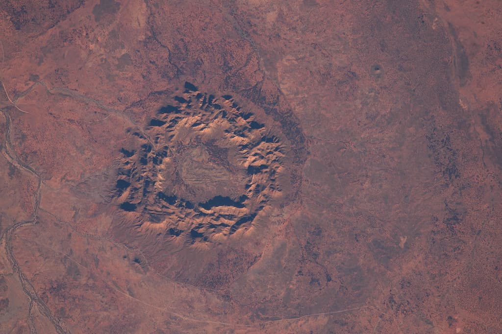
South of Cooktown in far north Queensland, a pile of massive black granite boulders rises from the tropical landscape. The Eastern Kuku Yalanji people know it as Kalkajaka — 'place of the spear' — and consider it a sacred battlefield where spirits dwell. They advise visitors not to enter. The mountain has obliged this warning through a history of disappearances that spans more than a century.
Black Mountain stands along the Trevathan Range in far north Queensland, approximately 25 kilometres south of Cooktown. It is not a mountain in the conventional sense but a vast accumulation of enormous black granite boulders, some the size of houses, piled upon one another in a formation that creates an interior labyrinth of passages, shafts, and cavities that has never been fully mapped.
To the Eastern Kuku Yalanji people, whose Country this is, Kalkajaka is a sacred battlefield of spirits and warring clan groups. It is the focus of several Dreaming stories, including the conflict between the black cockatoo and white cockatoo clans over hunting grounds. Specific sites on the mountain carry individual names and Dreaming associations: Kambi, a cave where flying foxes gather; Julbanu, a kangaroo-shaped rock facing Cooktown; Birmba, a stone oriented toward Helenvale. Elders warn visitors to stay clear, describing the mountain as a place of powerful and dangerous spiritual forces.
The mountain's reputation extends beyond Aboriginal tradition. Since the late 1800s, stories have accumulated of people, horses, and cattle disappearing into the boulder labyrinth and not returning. Search parties have themselves gone missing. Scientists attribute these disappearances to the physical hazards of the unmapped interior — chasms, disorientation, heat — but the pattern of vanishing has earned the mountain a second name: the Bermuda Triangle of Queensland.
Context and lineage
In one Dreaming narrative, Kalkajaka is a battlefield where the black cockatoo clan (inland) and the white cockatoo clan (coastal) fought over hunting grounds. In another, two warriors competed to build the highest mountain of rocks to win a maiden's hand, but a storm collapsed their constructions. These are publicly shared versions; deeper Dreaming knowledge is maintained by Traditional Owners.
The Eastern Kuku Yalanji people are the Traditional Owners and active custodians of Kalkajaka. They are involved in the management of the national park and maintain ongoing cultural authority over the site.
Why this place is sacred
Most sacred sites invite approach, even if they regulate it. Kalkajaka does the opposite. The Eastern Kuku Yalanji elders do not merely suggest caution; they warn visitors away. The mountain itself reinforces the warning through its physical nature — black granite that absorbs heat and light, an interior of unmapped passages where orientation fails, a surface that offers no trails, no handholds, no legible path.
The thinness here is not experienced through proximity but through distance. Standing at the viewing area, looking at a mountain one has been told not to enter by both its Traditional Owners and its own history, creates a quality of encounter unlike any other sacred site. The boundary is not a fence or a door but a convergence of spiritual authority, physical danger, and accumulated story that makes the boundary felt rather than seen.
The black colour of the granite — caused by a film of cyanobacteria on the rock surface — gives the mountain a visual weight that is almost gravitational. In sunlight, the boulders absorb rather than reflect, creating a dark mass in the tropical landscape that the eye registers as both solid and somehow absent.
Kalkajaka is a sacred battlefield and Dreaming site of the Eastern Kuku Yalanji people. Its ceremonial and spiritual functions are maintained by Traditional Owners and are not publicly documented.
The site's sacred status predates European contact. The disappearance stories that began in the late 1800s added a European layer of fear to an Aboriginal landscape already understood as dangerous and spiritually potent. National park gazettal in 1975 formalised the access restrictions that Traditional Owners had always maintained.
Traditions and practice
Kalkajaka's ceremonial significance is maintained by the Eastern Kuku Yalanji people. Specific practices are not publicly shared, in accordance with cultural protocols around restricted knowledge.
Traditional Owners are actively involved in the management of Kalkajaka National Park (CYPAL — Cape York Peninsula Aboriginal Land). Cultural authority over the site is maintained through joint management arrangements.
Approach the viewing area with the awareness that you are encountering a place whose custodians have asked visitors to maintain distance. The brevity of the visit is part of the site's teaching: not everything sacred is meant to be entered or consumed.
Eastern Kuku Yalanji
ActiveKalkajaka is a sacred battlefield and Dreaming site of the Eastern Kuku Yalanji people, who are the Traditional Owners and active custodians. The mountain holds deep spiritual significance and is associated with powerful and dangerous forces.
Cultural authority maintained through joint management of the national park. Ceremonial practices are not publicly documented, in accordance with cultural protocols.
Experience and perspectives
The Cooktown Developmental Road passes the mountain, and a car park and viewing area provide a clear sightline to the formation. From this distance, the mountain's character is immediately apparent: a massive pile of black boulders, treeless on its upper reaches, dark against the green tropical vegetation surrounding its base. The boulders are enormous, some several metres across, stacked and tumbled in arrangements that create visible gaps and shadows suggesting the labyrinth within.
There is nothing to do at Kalkajaka except look. There are no walking tracks, no interpretive signs of substance, no facilities. The absence of infrastructure is itself the message. This is a place whose custodians — both Aboriginal and governmental — have determined that the appropriate visitor experience is observation from a distance.
The looking is not passive, however. Knowing the Dreaming stories, knowing the disappearance accounts, knowing the elders' warnings, the eye searches the black surface for something it cannot name. The mountain does not yield its interior to the gaze any more than it yields to physical entry. It remains opaque, absorptive, and complete in its refusal to be known from outside.
Drive to the viewing area. Look. Listen to the wind. Consider what it means to encounter a sacred place that asks you not to come closer. The brevity of the visit is not a limitation but the appropriate form of engagement with a site whose power operates through distance and boundary.
Kalkajaka operates through refusal — a sacred site whose power is expressed through the boundary it maintains between itself and those who approach it.
Geologically, the mountain is a granite intrusion approximately 260 million years old, exposed and weathered into the current boulder pile. The black coloration is caused by a film of cyanobacteria on the rock surface. The internal structure of passages and cavities has not been fully mapped.
For the Eastern Kuku Yalanji people, Kalkajaka is a place of powerful and dangerous spiritual forces — a sacred battlefield where spirits dwell. Elders' warnings to visitors are not superstition but genuine spiritual counsel from the site's custodians. The Dreaming stories attached to the mountain are living narratives maintained by the community.
The disappearance stories have generated significant paranormal and mystery interest, with comparisons to the Bermuda Triangle. Various unexplained phenomena have been reported by visitors and local residents.
The interior of the boulder labyrinth has never been fully explored or mapped. What lies within the mountain's passages and cavities is genuinely unknown. The mountain keeps its interior to itself.
Visit planning
Located along the Cooktown Developmental Road in far north Queensland, approximately 25 km south of Cooktown. Car park and viewing area accessible by car. No walking tracks or facilities.
Cooktown (25 km north) offers accommodation.
Remain in the car park and viewing area. Do not attempt to enter the mountain. Respect Traditional Owner warnings.
No specific requirements for the viewing area.
Photography from the viewing area is permitted.
None expected or appropriate.
Do not enter the boulder formation under any circumstances | No walking tracks exist — do not attempt to create informal trails | No camping | Respect Traditional Owner cultural authority
Plan your visit
Address
Rossville QLD 4895, Australia
Phone
Hours
Hours, fees, and access can change — verify on the official source before you travel. Practical details last checked Jun 2026.
Nearby sacred places
Sacred places within a half-day’s reach. Pilgrims often visit them together: walk one, stay for the other.


References
Sources consulted when researching this page. Independent verification by readers is welcome.
- 01Kalkajaka, the mysterious Black Mountain - This Place — Indigenous.gov.auhigh-reliability
- 02Kalkajaka National Park - Queensland Parks — Queensland Governmenthigh-reliability
- 03Kalkajaka National Park - Wikipedia — Wikipedia contributors
- 04Black Mountain Kalkajaka National Park - Queensland Tourism — Queensland.com
- 05Black Mountain National Park - Travel Spiced Life — Travel Spiced Life
Key questions
What pilgrims usually ask
- Why is Black Mountain considered sacred?
- Sacred Aboriginal site in far north Queensland. Eastern Kuku Yalanji Traditional Owners warn visitors to stay clear of this mountain of black granite boulders.
- What should I wear at Black Mountain?
- No specific requirements for the viewing area.
- Can I take photos at Black Mountain?
- Photography from the viewing area is permitted.
- How long should I spend at Black Mountain?
- 30 minutes to 1 hour at the viewing area.
- How do you visit Black Mountain?
- Located along the Cooktown Developmental Road in far north Queensland, approximately 25 km south of Cooktown. Car park and viewing area accessible by car. No walking tracks or facilities.
- What offerings are appropriate at Black Mountain?
- None expected or appropriate.
- What etiquette should visitors follow at Black Mountain?
- Remain in the car park and viewing area. Do not attempt to enter the mountain. Respect Traditional Owner warnings.
- What is the history of Black Mountain?
- In one Dreaming narrative, Kalkajaka is a battlefield where the black cockatoo clan (inland) and the white cockatoo clan (coastal) fought over hunting grounds. In another, two warriors competed to build the highest mountain of rocks to win a maiden's hand, but a storm collapsed their constructions. These are publicly shared versions; deeper Dreaming knowledge is maintained by Traditional Owners.