Country guide
China
China brings together sacred architecture, pilgrimage traditions, and landscapes shaped by memory, ritual, and local devotion.
47 sacred sites across 21 regions. Use the tradition and site-type filters to narrow in.
Atlas summary
China sacred sites overview
China sacred sites include living temples, shrines, churches, pilgrimage places, ruins, and sacred landscapes indexed across the Pilgrim Map atlas.
Use this guide to compare regional clusters, represented traditions, and common site types before opening individual pages for visiting context and deeper background.
| Coverage | 47 sacred sites across 21 regions. |
|---|---|
| Regional clusters | |
| Traditions | |
| Site types | |
| UNESCO heritage | 3 UNESCO-tagged sites in this country guide. |
By tradition
Showing 1-47 of 47 sites in this country guide
Beiyue Hengshan Mountain
Datong, Shanxi, China
Beiyue Hengshan is the Northern Great Mountain of China's Five Sacred Peaks — the cosmic axis points that have anchored Chinese civilization's relationship with heaven for...
Drak Yerpa
Lhasa, Tibet, China
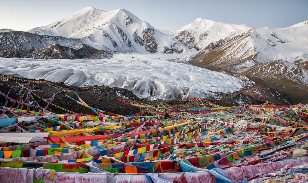
Drak Yerpa is a limestone cliff amphitheater northeast of Lhasa containing 108 meditation caves sanctified by twelve centuries of contemplative practice....
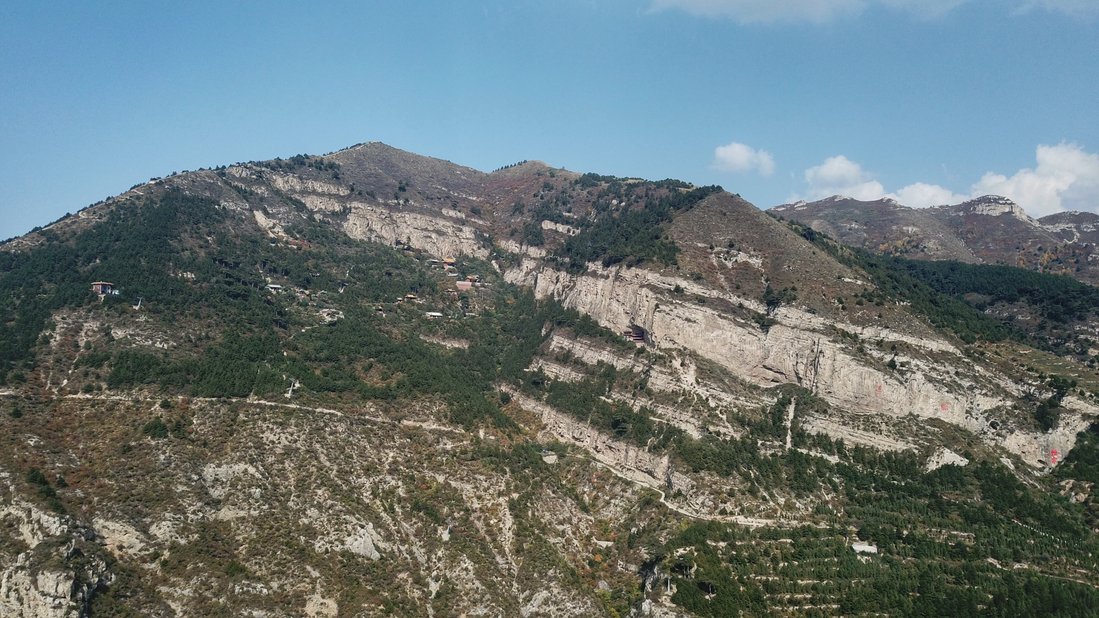
Fanjingshan mountain and temple, Tongren
Tongren, Guizhou, China
Rising from the primordial forests of Guizhou, Fanjingshan is China's Fifth Sacred Buddhist Mountain and the earthly throne of Maitreya, the Buddha yet to come....

Ganden Monastery
Lhasa, Tibet, China
Ganden Monastery, founded by Tsongkhapa in 1409 on a mountain ridge east of Lhasa, is the mother monastery of the Gelug school — the largest institution in Tibetan...
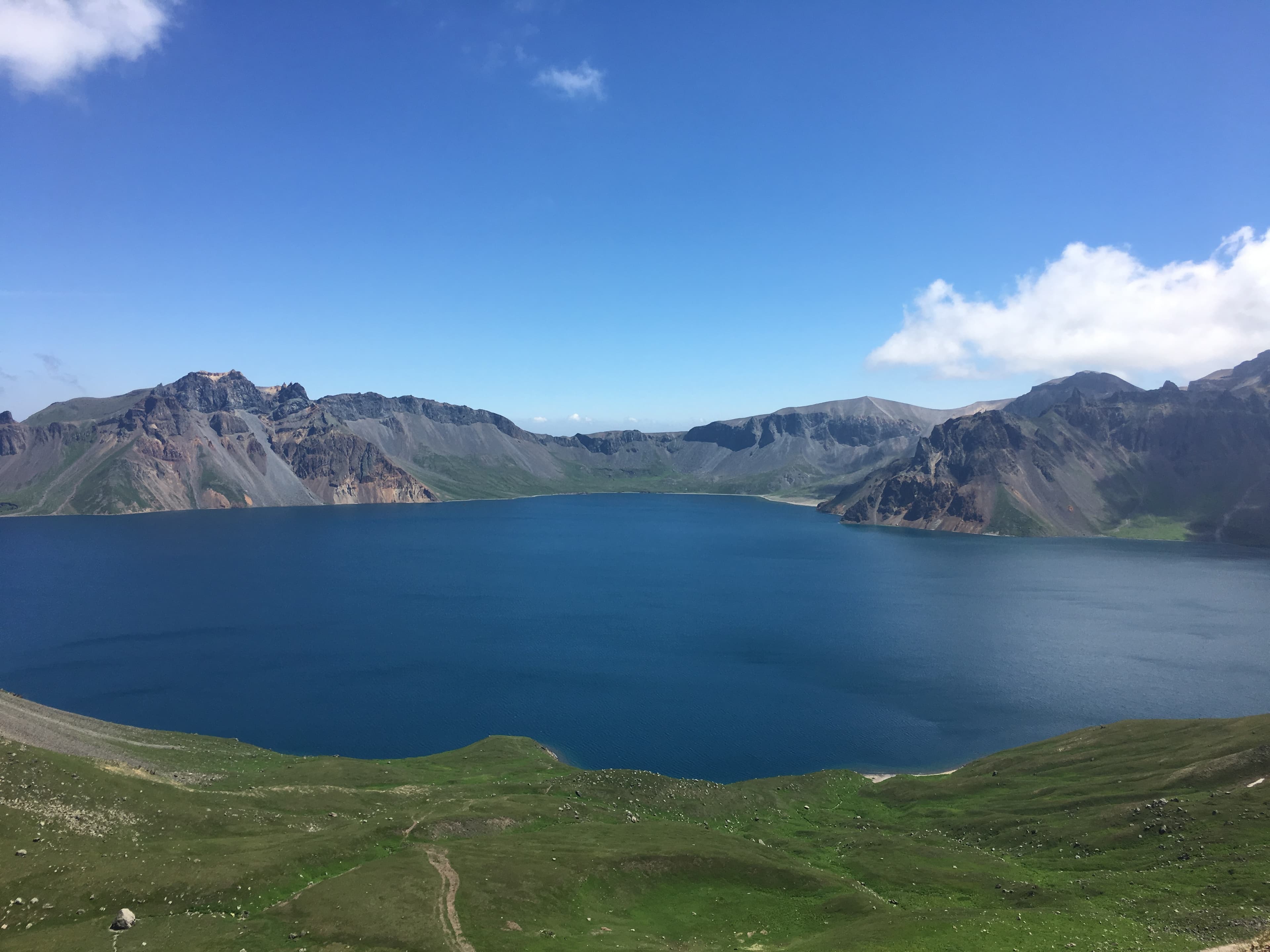
Haven Lake and Changbai (Paektu) Mountain
Changbai, Jilin, China
Mount Paektu rises 2,744 meters from the borderlands between China and North Korea, the highest peak in Northeast Asia, crowned by Heaven Lake hidden within its ancient...
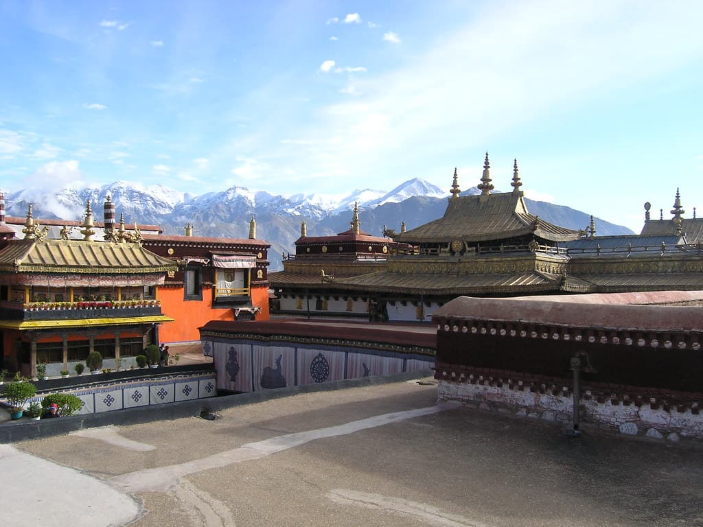
Jokhang Temple
Chengguan District, Tibet, China
For nearly fourteen hundred years, Jokhang Temple has stood at the center of Tibetan Buddhism, housing what is believed to be the most sacred Buddha image in existence....

Lake Nam Tso
Baingoin County, Tibet, China
Lake Nam Tso sits at 4,718 meters on the Tibetan plateau, one of the highest large lakes in the world and one of the three holiest in Tibet....

Lake Yamzho Yumco
Ngarzhag, Tibet, China
Lake Yamzho Yumco — Yamdrok — is one of Tibet's three holiest lakes and the one most charged with existential meaning....
Leshan Giant Buddha
Leshan, Sichuan, China
For ninety years, three generations of craftsmen carved Maitreya Buddha into the cliffs where three rivers meet at Leshan....

Longmen Grottoes
Luolong District, Henan, China
The Longmen Grottoes stretch along the limestone cliffs of the Yi River south of Luoyang, a kilometer of carved Buddhist figures numbering over 110,000....
Lushan Mountain
Jiujiang, Jiangxi, China
Rising above the Yangtze plain, Mount Lu has drawn monks, scholars, and poets for over sixteen centuries....

Mount Gongga
Kangding, Sichuan, China
Mount Gongga rises 7,556 meters above the eastern edge of the Tibetan Plateau in Sichuan Province, the highest peak in the region by thousands of meters....

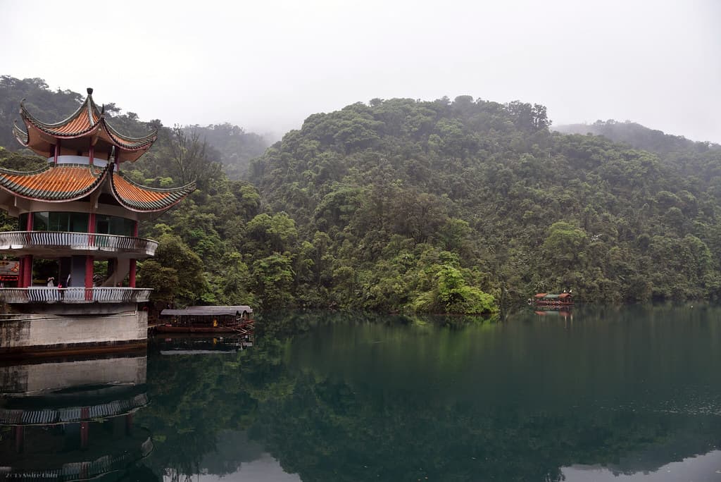
Mount Putuo (Pǔtuó Shān)
Zhoushan, Putuo District, Zhoushan, Zhejiang Province, China
Mount Putuo is an island monastery-city in the East China Sea, venerated for over a thousand years as the earthly dwelling place of Guanyin, the bodhisattva of compassion....
Mt. Amnye Machen
Maqên, Qinghai, China
Amnye Machen rises to 6,282 meters from the grasslands of the Golok Tibetan Autonomous Prefecture in Qinghai Province, an entire mountain range wrapped in the great bend...
Mt. Dinghushan
Dinghu District, Guangdong Province, China
Dinghushan rises above the city of Zhaoqing in Guangdong Province, a mountain of ancient subtropical forest sheltering Qingyun Temple, one of the most important Buddhist...
Mt. Emei Shan
双水井, Sichuan, China
Mount Emei rises 3,099 meters from the Sichuan Basin, one of the Four Sacred Buddhist Mountains of China and the bodhimanda of Samantabhadra, the bodhisattva of universal...

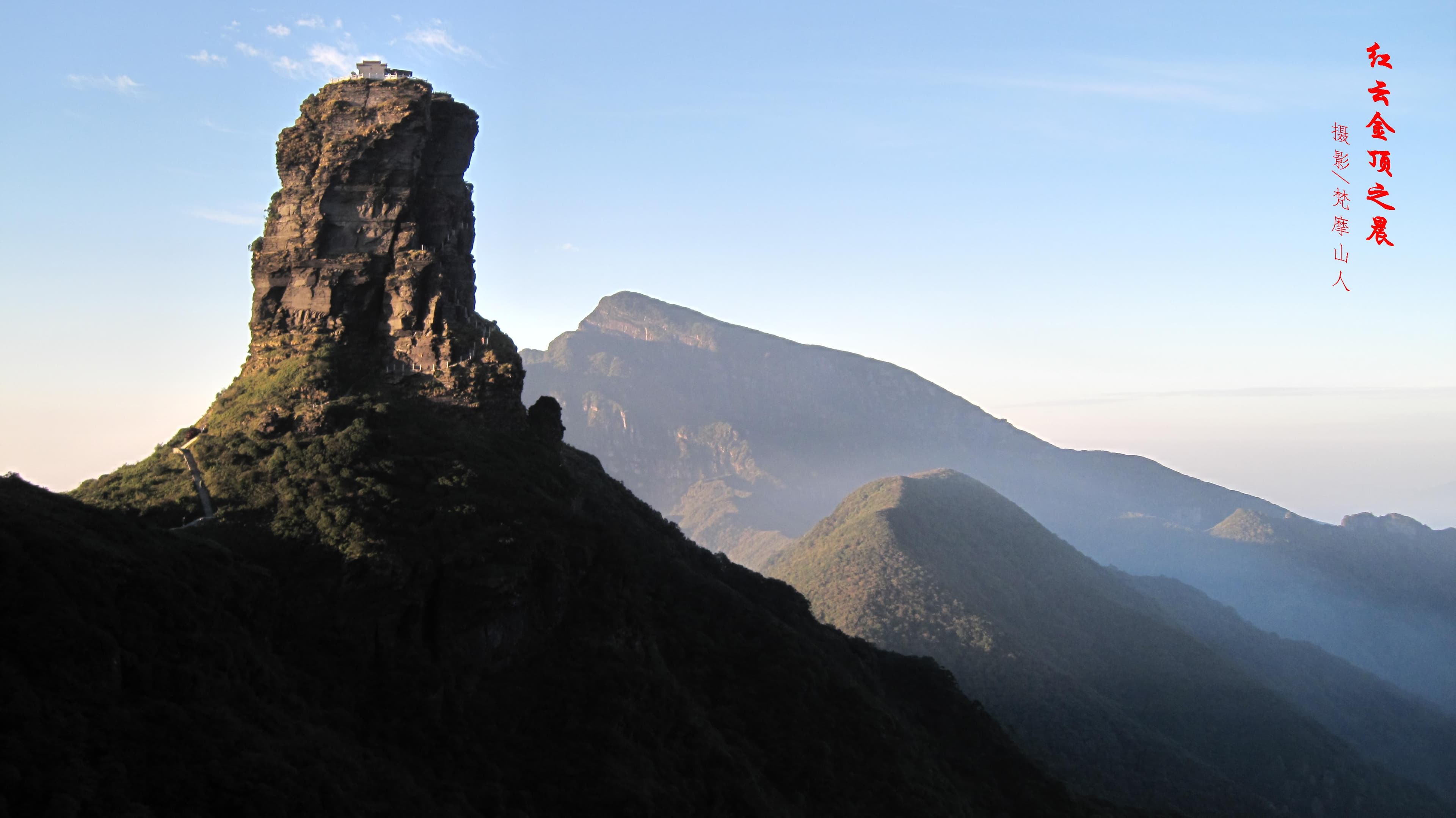
Mt. Fanjing, Guizhou, China
Yinjiang Tujia and Miao Autonomous County, Guizhou, China
Fanjingshan rises 2,570 meters from the forests of northeastern Guizhou Province, a UNESCO World Heritage Site recognized for its extraordinary biodiversity and revered as...

Mt. Gu Shan
Gushan, Fujian, China
Gu Shan, Drum Mountain, rises from the eastern suburbs of Fuzhou in Fujian Province, its summit crowned by a rock that resonates like a drum in wind and rain....

Mt. Heng Shan Nan
Hengyang, Hunan, China
Heng Shan rises across 72 peaks in Hunan Province, the Southern Peak of the Five Great Mountains that have anchored Chinese cosmology for over three millennia....

Mt. Hua Shan
Huayin City, Shaanxi, China
Hua Shan rises 2,155 meters from the Wei River plain in Shaanxi Province, the Western Peak of the Five Great Mountains and the most dramatically Taoist of the group....

Mt. Huang Shan
Huangshan District, Anhui, China
Huangshan rises from southern Anhui Province in a formation of granite peaks, ancient pines, and cloud phenomena that has defined the Chinese aesthetic imagination for...

Mt. Jiuhua Shan
Chizhou, Anhui, China
Jiuhua Shan rises from the Anhui countryside as one of China's Four Sacred Buddhist Mountains, dedicated to Ksitigarbha — the bodhisattva who vowed not to achieve...

Mt. Kailash
Darchen, Tibet, China
Mount Kailash rises 6,638 meters from the Tibetan plateau—four sheer faces matching the four cardinal directions, standing in geometric solitude that seems more...

Mt. Lao Shan
Laoshan District, Shandong, China
Laoshan rises from the shore of the Yellow Sea near Qingdao, the highest coastal mountain along China's shoreline....
Mt. Luo Fu Shan
Huizhou, Guangdong Province, China
Luofu Shan in Guangdong Province is one of the Ten Great Cave Heavens of Taoist sacred geography — a classification that places it among the most spiritually significant...

Mt. Mai Ji Shan
Maiji, Gansu, China
Maijishan rises from the forests of Gansu Province as a solitary haystack-shaped cliff, its red sandstone face honeycombed with 194 caves containing approximately 7,800...

Mt. Mao Shan, Jiangsu
Jintan District, Jiangsu, China
Maoshan in Jiangsu Province holds the distinction of being the First Blessed Land and Eighth Cave Heaven in Taoist sacred geography — the highest classifications in the...

Mt. Meili Xue
Zogang County, Tibet, China
Kawagebo, the 6,740-meter summit of the Meili Snow Mountains on the Yunnan-Tibet border, is the highest unclimbed peak over 6,000 meters in the world....

Mt. Pu Tuo Shan
Putuo District, Zhejiang, China
Putuo Shan is a small island in the East China Sea that serves as the earthly home of Guanyin — the Bodhisattva of Compassion and the most beloved figure in Chinese...

Mt. Qi Yun Shan
Huangshan, Anhui, China
Qiyun Shan, one of the Four Sacred Mountains of Taoism, rises as a formation of red Danxia sandstone in Anhui Province....
Mt. Qian Shan, Liaoning
Wenquan Subdistrict, Liaoning, China
Qian Shan — Thousand Mountain — rises from the Liaoning plain in northeastern China with 999 peaks, each said to resemble a lotus petal....

Mt. San Qing Shan
Sanqing, Jiangxi, China
Sanqingshan — the Mountain of the Three Pure Ones — is a UNESCO World Heritage Site in Jiangxi Province where granite pillars and pinnacles rise through cloud seas in...

Mt. Song Shan
Gongyi, Henan, China
Songshan is the Central Peak of China's Five Sacred Mountains, the axis around which the cosmos turns in traditional Chinese cosmology....

Mt. Tai Shan
Taishan District, Shandong, China
Mount Tai is the mountain of the Chinese state itself, the place where heaven and earth meet, where the emperor's authority was validated by the cosmos....

Mt. Targo and Lake Dangra
Targo, Tibet, China
Dangra Yumco and Dargo Mountain form a sacred married couple in the Bon tradition, Tibet's pre-Buddhist indigenous religion....

Mt. Tiantai Shan
Tiantai County, Zhejiang, China
Mount Tiantai is the birthplace of Tiantai Buddhism, the first purely Chinese school of Buddhist philosophy....

Mt. Wu Tai Shan
Taihuai, Shanxi, China
Mount Wutai is the earthly home of Manjushri, the Bodhisattva of Wisdom, identified in the Avatamsaka Sutra as residing on a Clear Cool Mountain in the northeast....

Mt. Wu Tang Shan
Danjiangkou City, Hubei, China
Wudangshan is one of the Four Sacred Mountains of Taoism, the dwelling place of Zhenwu, the Perfected Warrior who governs the northern quarter of heaven....

Mt. Wu Yi Shan
Wuyishan, Fujian, China
Wuyishan holds a rare convergence: Taoist Grotto Heaven where immortals dwelt, birthplace of Neo-Confucianism where Zhu Xi rewrote East Asian philosophy, and the mountain...

Potala Palace
Chengguan District, Tibet, China
The Potala Palace rises 117 meters above the Lhasa Valley on the Red Hill, named for Avalokiteshvara's mythical abode, Mount Potalaka....

Sakya
Tashigang, Tibet, China
Sakya Monastery is the seat of the Sakya school of Tibetan Buddhism, one of the four major schools, founded in 1073 by the Khon family, who trace their ancestry to...

Samye
Samye, Tibet, China
Samye is where Buddhism became institutionally rooted in Tibet, the place where a religion became a civilization....

Tashilhunpo
城西街道, Tibet, China
Tashilhunpo Monastery rises from the slopes of Niseri Hill in Shigatse, a 37-acre compound of gilded rooftops and whitewashed walls that has served as the seat of the...

Toling
Tsamda County, Tibet, China
Toling Monastery stands in the surreal Zanda Earth Forest of western Tibet, nearly 1,200 kilometers from Lhasa....

Yungang Grottoes
Datong, Shanxi, China
The Yungang Grottoes stretch for a kilometer along a sandstone cliff face near Datong, Shanxi Province, a procession of 252 caves containing over 51,000 carved Buddhist...

Zhongnan-shan
Chang'an District, Shaanxi, China
The Zhongnan Mountains rise south of Xi'an, forming the central section of the Qinling range....

Zuojiang Huashan Rock Art
Guangxi, Guangxi, China
Along 105 kilometers of the Zuojiang River and its tributaries in Guangxi, 1,951 painted figures spread across 38 cliff sites, the largest concentration of rock art in...
Key questions
China sacred-site questions
- What sacred sites can I explore in China?
- Pilgrim Map lists sacred places in China across living worship sites, heritage landmarks, pilgrimage destinations, and culturally significant landscapes. The current guide lists 47 sites organized by region, tradition, and site type.
- Which traditions are represented in China?
- The most represented traditions include Buddhism, Taoism, Indigenous, Hinduism.
- How should I plan a sacred-site visit in China?
- Start with regional clusters, compare nearby places on the map, then open individual site pages for coordinates, etiquette, and sacred context where available.
- Can I view China sacred sites on a map?
- Yes. Switch to map view to compare geographic clusters, then open individual site pages for coordinates, visiting context, and related places.