Kümbet
An Iron Age Phrygian city where a mother-goddess façade was overwritten with a cross — and both marks remain
Eskişehir, Seyitgazi, Turkey
Plan this visit
Practical context before you go
1–2 hours for the main monuments (Berberini Façade, rock church, Asar Kale fortress); allow a half day to explore the wider area including the Lion Tomb and Tomb of Himmet Baba.
Kümbet village is approximately 75 km from Eskişehir, 36 km south of Seyitgazi, and 2 km east of the D-665 highway (Eskişehir–Afyonkarahisar). GPS: approximately 39.2109°N, 30.6056°E. On the Phrygian Way long-distance hiking trail. A vehicle is recommended; public transport from Eskişehir may require multiple connections via Seyitgazi. Mobile signal may be limited in the village area — verify route and conditions before travel. Check current access conditions with the Eskişehir Provincial Directorate of Culture and Tourism.
Kümbet is a living village as well as an archaeological site. The monuments are integrated into an inhabited landscape, and visitors should be aware of both archaeological and community respect.
At a glance
- Coordinates
- 39.2109, 30.6056
- Type
- Archaeological Site
- Suggested duration
- 1–2 hours for the main monuments (Berberini Façade, rock church, Asar Kale fortress); allow a half day to explore the wider area including the Lion Tomb and Tomb of Himmet Baba.
- Access
- Kümbet village is approximately 75 km from Eskişehir, 36 km south of Seyitgazi, and 2 km east of the D-665 highway (Eskişehir–Afyonkarahisar). GPS: approximately 39.2109°N, 30.6056°E. On the Phrygian Way long-distance hiking trail. A vehicle is recommended; public transport from Eskişehir may require multiple connections via Seyitgazi. Mobile signal may be limited in the village area — verify route and conditions before travel. Check current access conditions with the Eskişehir Provincial Directorate of Culture and Tourism.
Pilgrim tips
- No specific requirements; practical clothing for hiking at altitude (1,069 m) and rural terrain.
- Permitted at monuments. Be aware that you are also in a living village when photographing.
- Conservation is a documented concern at Kümbet — the monuments lack formal protection infrastructure, and some are on farmland. Do not damage rock surfaces or inscriptions. The Berberini Façade is particularly vulnerable; the inscription is irreplaceable.
Overview
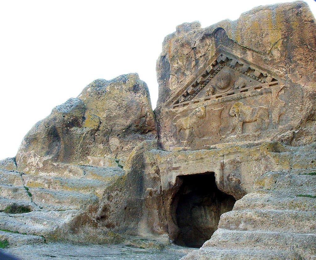
Kümbet village in Eskişehir province occupies the site of ancient Meros, a Phrygian city from the Iron Age. Among its monuments is the Berberini Façade, a small niche carved into rock bearing a formal inscription to Matar — the Phrygian name for the mother goddess — alongside a Byzantine cross engraved over the destroyed image of the goddess herself. The theological overwriting is still visible. So is what it tried to replace.
The village of Kümbet sits at 1,069 meters in the Eskişehir highlands, where the Phrygian Iron Age city of Meros once stood. Scattered across the rocky terrain above the modern houses are the monuments of that older city: a hilltop fortress with carved cisterns and silos, rock-cut tombs on the mound slope, and — most telling — the Berberini Façade, a small niche carved into the living rock in the mid-6th century BCE.
The façade is modest in scale: 2.10 meters high, 1.20 meters wide. Its Old Phrygian inscription, one of a body of texts that record the language of a civilization that shaped the ancient Mediterranean world, dedicates the site formally to Matar — 'the Mother,' the figure the Greeks would absorb and rename Kybele or Cybele. In the central niche where her image once stood, a Byzantine cross has been carved. The idol was destroyed; the cross replaced it. This is a physical record of religious transition, not described in documents but legible in stone.
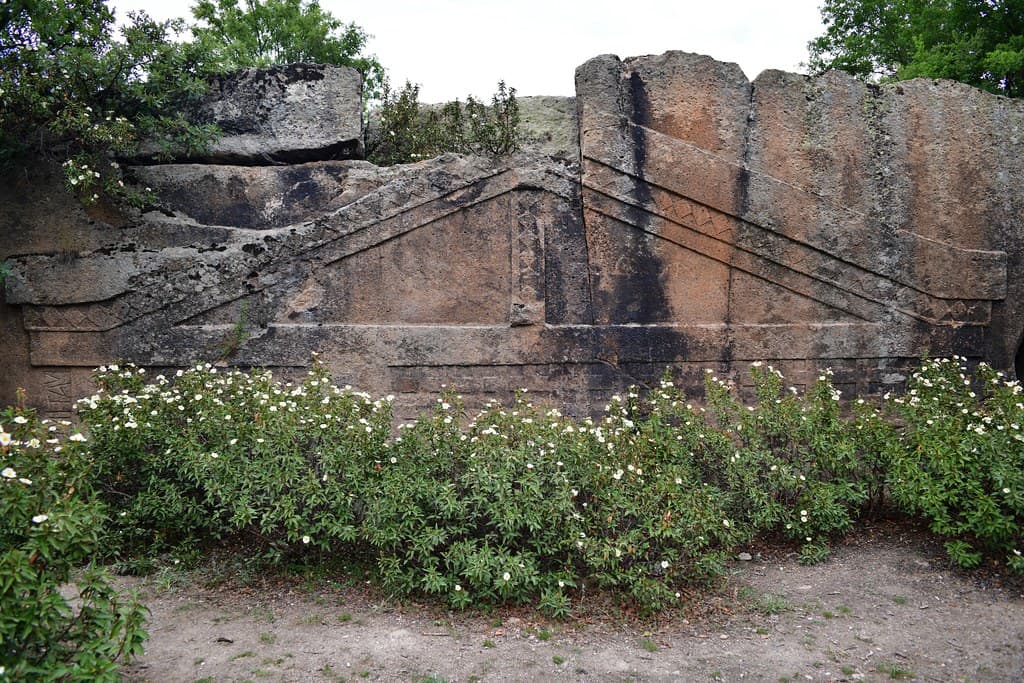
On the western side of the same rock mass, a Byzantine church was carved — the Christianization of the site proceeding through architecture as well as iconography. The Phrygians made the rock sacred; the Byzantines made it theirs.
What remains is layered rather than resolved. Hikers on the Phrygian Way pass through Kümbet today alongside the same boulders that Phrygian craftsmen inscribed twenty-six centuries ago, in a language only recently partially understood.
Context and lineage
The city of Meros occupied this highland site from approximately 1200 BCE, part of the Phrygian cultural florescence that spread across central and western Anatolia after the collapse of the Hittite Empire. The Phrygians built their sacred architecture into the landscape's natural rock — at Kümbet, the Berberini Façade was carved in the mid-6th century BCE and formally inscribed with a dedication to Matar, making this one of the few Phrygian cult sites with surviving textual evidence of its dedication.
Local tradition holds that ancient Meros introduced advanced water supply and sewage systems to Anatolia — a claim preserved in regional historical accounts, though its specific basis is unclear. During the Byzantine period, the sacred site was Christianized through both the destruction of the goddess image and the carving of a rock church on the same rock mass — a pattern visible across the Phrygian Valley wherever Phrygian shrines were too significant to simply abandon.
Phrygian city of Meros (c. 1200–333 BCE) → Roman and Byzantine reuse → Byzantine Christianization of Phrygian sacred monuments → Abandonment → Modern village of Kümbet; part of Phrygian Valley heritage region on Turkey's UNESCO Tentative List
E. Brandenburg
German researcher who first documented the Berberini Façade in 1901, establishing its existence in the scholarly record
Why this place is sacred
Phrygian religion was centered on Matar, the divine mother whose body was the earth and whose presence was felt in the living rock. The Berberini Façade at Kümbet is not simply a monument to this theology but a formal declaration of it — an inscription in Old Phrygian dedicating the carved niche to the goddess makes this one of the few Phrygian sacred sites where the dedication is preserved in writing rather than inferred from form.
The inscription (designated W-02 in the corpus of Phrygian epigraphic sources) dates the façade to approximately the mid-6th century BCE, placing it in the period of the Phrygian cultural florescence when the valley's most elaborate rock monuments were being carved. What was in the niche — the Matar image — is gone. But the cross that replaced it is still there, and the shape of the original niche is still readable around it.
This palimpsest is Kümbet's most significant quality as a sacred site. The Phrygian Valley's monuments are often interpreted in isolation — this façade, that tomb, this fortress — but at Kümbet the sequence of religious replacement is compressed into a single carved rock face. The goddess's niche, the cross, and the adjacent Byzantine church on the same rock mass make the site a meditation on how sacred power transfers across traditions while the sacred place itself persists.
Formal dedicatory shrine to Matar (Kybele), the Phrygian mother goddess, carved mid-6th century BCE. The adjacent Asar Kale fortress and rock-cut tombs functioned as the civic and funerary infrastructure of the Phrygian city of Meros.
Phrygian city of Meros (Iron Age, c. 1200–333 BCE) → Roman settlement → Byzantine Christianization of the sacred site (rock church carved, Matar image destroyed, cross inscribed) → Ottoman period abandonment → Modern village of Kümbet; ongoing heritage protection concerns
Traditions and practice
Phrygian veneration of Matar at the Berberini niche, including formal dedicatory ceremonies implied by the inscribed invocation. Funerary rites at the Lion Tomb (Tomb of Solon) and Tomb of Himmet Baba. Phrygian civic and agricultural life organized around the Asar Kale fortress. During the Byzantine period, Christian worship in the rock-cut church carved beside the older shrine.
Heritage tourism and hiking on the Phrygian Way. Local guides active in the broader Phrygian Valley region. Ongoing scholarly documentation and conservation advocacy for the site's monuments.
Spend time at the Berberini Façade before moving to the other monuments. Read what you can see: the inscription above the roofline (even without knowing Old Phrygian, the formal care of the carving is readable), the shape of the niche, the cross inside it. Notice what is absent — the image that once stood in the niche — and what replaced it.
Then move to the western face of the same rock and find the Byzantine church entrance. You are now on the other side of the same stone. The theological argument between these two traditions is physically located in a single boulder.
Climb to the Asar Kale fortress afterward, taking time for the elevation. The cisterns and silos carved into the rock are practical architecture — Iron Age infrastructure for the settlement below — but they are carved with the same disciplined hand that produced the Berberini inscription. The Phrygians did not distinguish between the sacred and the functional in the same way later traditions would.
Phrygian
HistoricalKümbet (ancient Meros) was a Phrygian city from approximately 1200–333 BCE. The Berberini Façade is one of the few Phrygian cult sites where an explicit written dedication to Matar survives — a formal inscription (W-02) in Old Phrygian language, mid-6th century BCE, making this a documented site of the mother goddess cult rather than one inferred from architectural form alone.
Formal dedicatory ceremonies at the Berberini niche; Phrygian civic and agricultural life organized around the Asar Kale fortress; funerary rites at rock-cut tomb façades on the mound slope.
Byzantine Christian
HistoricalA Byzantine rock church was carved on the western face of the Berberini rock mass, and the Matar figure in the niche was destroyed and replaced with a cross. This deliberate act of sacred overwriting demonstrates Byzantine practice of Christianizing Phrygian cult sites that were too significant or deeply embedded in the landscape to simply abandon.
Christian worship in the rock-cut church; deliberate replacement of the Phrygian goddess image with the cross.
Archaeological/Scholarly
ActiveKümbet is documented by the Phrygian Monuments project and is part of the 'Mountainous Phrygia' UNESCO Tentative List area (2022). The Berberini inscription (W-02) is a key primary source for the Phrygian language corpus. Conservation advocacy for the inadequately protected monuments is an active concern.
Archaeological documentation, epigraphic study of the Berberini inscription, heritage protection advocacy, guided tours.
Experience and perspectives
Kümbet sits at 1,069 meters — high enough that the Eskişehir plain is visible on clear days as a distant horizontal line. The village is still inhabited, its houses among the rocks and fields that once formed the city of Meros. The transition from modern village to Iron Age monument happens without ceremony: the Berberini Façade is simply there, a small carved niche in a boulder, not enclosed or protected.
Approach the façade slowly. It is small — the scale is intimate rather than monumental, which makes the theological weight of the inscription all the more concentrated. The Old Phrygian text above the pitched roof of the carved niche is the formal language of dedication. The niche below it held an image of the goddess. The cross carved into the niche is later, rougher, deliberate.
Turn around from the Berberini rock and look at the western face: the Byzantine church was cut here, its carved interior accessible through a low opening. The Phrygians made this rock sacred from one direction; the Byzantines responded from the other. Both marks survive.
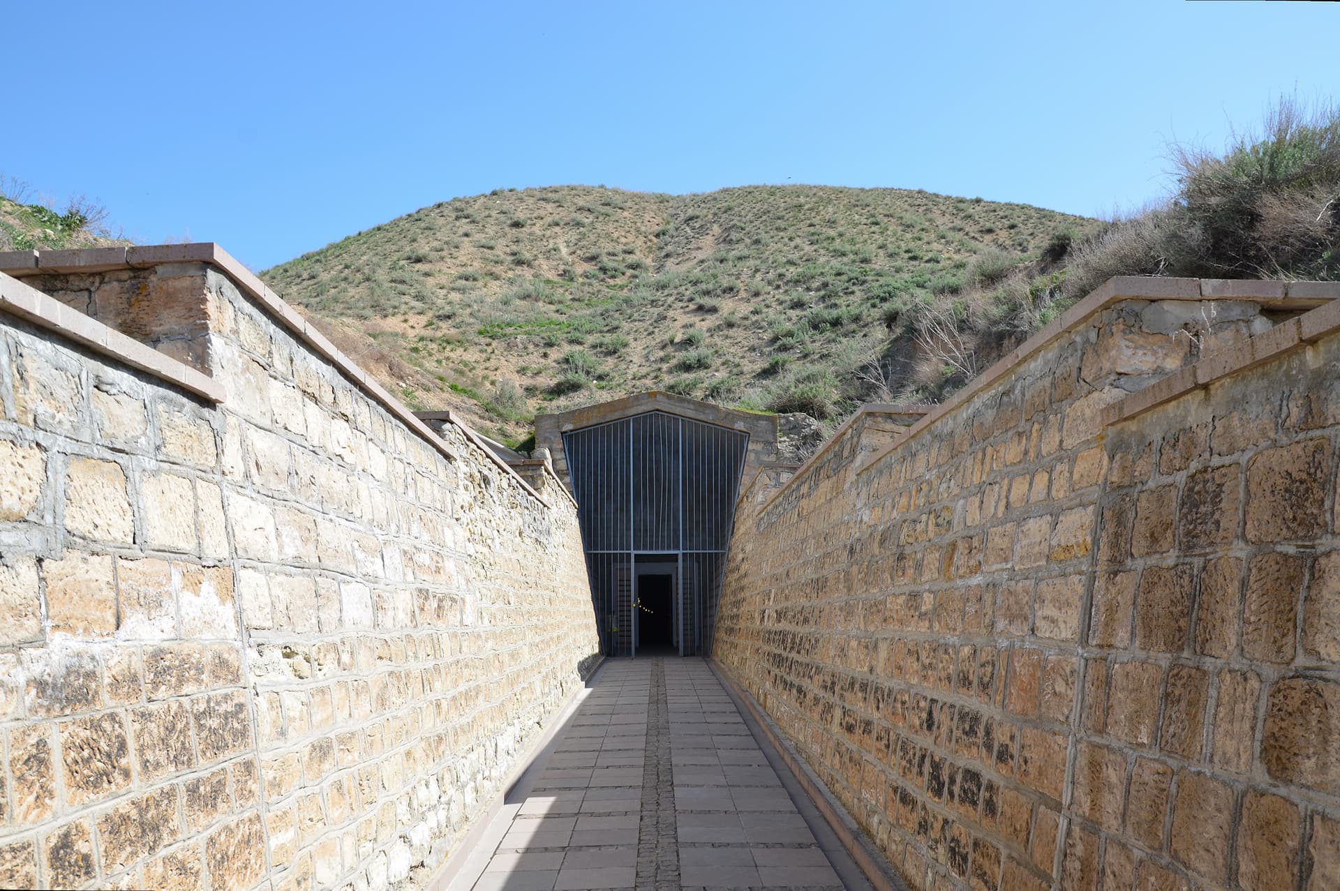
For the Asar Kale fortress, climb the hill above the village. The carved cisterns and silos are still visible in the rock. At the top, the view is wide — you can see why this position was chosen, and you can see, looking down, the village that has been continuously inhabited in the shadow of this hill for over three thousand years.
The Phrygian Way passes through Kümbet, making it a natural stopping point on a multi-day walk. Arriving on foot, with the elevation gain from the valley, gives the site a different quality than arriving by car.
Kümbet village is 75 km from Eskişehir and 2 km east of the D-665 highway. The Berberini Façade is in the village; the Asar Kale fortress is above it. The Phrygian Way passes through. Allow at least 1–2 hours for the main monuments.
Kümbet is interpreted through the lens of Phrygian archaeology, the study of Phrygian religious language and cult, and the broader story of religious transition across the ancient Mediterranean world.
The Berberini Façade's Old Phrygian inscription (W-02) is a primary source for both the Phrygian language and Phrygian religious practice — a formal dedicatory text of the kind that allows scholars to understand how Phrygian speakers conceptualized their relationship to Matar. The deliberate overwriting of the niche with a Byzantine cross is understood as evidence of the Christianization of Phrygian sacred sites, a pattern documented across the valley. The broader Kümbet site (ancient Meros) demonstrates the continuity of highland settlement from the Iron Age through the Byzantine period at a single location.
No living community maintains direct ritual connection to Kümbet's Phrygian monuments. The Phrygian religious tradition ended as a living practice in antiquity. Regional awareness of the Phrygian heritage is preserved through Turkish national heritage programs, the Phrygian Way trail, and scholarly documentation.
The Phrygian Valley, including Kümbet, is a significant site in neo-pagan and goddess-spirituality traditions interested in the pre-classical Anatolian Earth Mother. The Berberini Façade, with its formal inscription to Matar, is treated by some contemporary practitioners as a surviving textual address to the goddess — a place where the dedication, if not the image, remains legible.
The full extent of the city of Meros beneath the modern village is unmapped. The nature of the specific religious community that used the Berberini Façade — whether it served a household, a guild, a priesthood, or a wider community — is unknown beyond the dedicatory inscription itself. The original image in the niche is lost.
Visit planning
Kümbet village is approximately 75 km from Eskişehir, 36 km south of Seyitgazi, and 2 km east of the D-665 highway (Eskişehir–Afyonkarahisar). GPS: approximately 39.2109°N, 30.6056°E. On the Phrygian Way long-distance hiking trail. A vehicle is recommended; public transport from Eskişehir may require multiple connections via Seyitgazi. Mobile signal may be limited in the village area — verify route and conditions before travel. Check current access conditions with the Eskişehir Provincial Directorate of Culture and Tourism.
No accommodations in Kümbet village. Seyitgazi (36 km north) may offer limited guesthouse options. Eskişehir (75 km north) offers the full range. For Phrygian Way hikers, camping in the valley is possible in some areas — consult Phrygian Way trail resources.
Kümbet is a living village as well as an archaeological site. The monuments are integrated into an inhabited landscape, and visitors should be aware of both archaeological and community respect.
No specific requirements; practical clothing for hiking at altitude (1,069 m) and rural terrain.
Permitted at monuments. Be aware that you are also in a living village when photographing.
Not applicable.
Do not damage rock surfaces or inscriptions. Some monuments may be on private farmland — if in doubt, ask locally before crossing field boundaries.
Nearby sacred places
Sacred places within a half-day’s reach. Pilgrims often visit them together: walk one, stay for the other.


References
Sources consulted when researching this page. Independent verification by readers is welcome.
- 01Kümbet Valley - Phrygian Monuments — Phrygian Monuments Projecthigh-reliability
- 02Berberini Façade - Vici.org — Vici.org contributorshigh-reliability
- 03Kümbet Asar Kale - Vici.org — Vici.org contributorshigh-reliability
- 04Phrygian Rock-Cut Thrones, 'Idols' and Phrygian Royal Symbolism — Academia.eduhigh-reliability
- 05Kümbet, Seyitgazi - Wikipedia — Wikipedia contributors
- 06Phrygian (Iron Age: BC 1200-333) - Seyitgazi Tourism — Seyitgazi Tourism Authority
- 07Eskişehir's hidden artifacts need protection — Hürriyet Daily News
- 08Kümbet North Tomb [Deliklikaya, Lonely Tomb] Rock Cut Tomb — The Megalithic Portal
Key questions
What pilgrims usually ask
- Why is Kümbet considered sacred?
- Phrygian city of Meros, Eskisehir. The Berberini Facade holds an Old Phrygian dedication to Matar, with a Byzantine cross carved over the destroyed idol.
- What should I wear at Kümbet?
- No specific requirements; practical clothing for hiking at altitude (1,069 m) and rural terrain.
- Can I take photos at Kümbet?
- Permitted at monuments. Be aware that you are also in a living village when photographing.
- How long should I spend at Kümbet?
- 1–2 hours for the main monuments (Berberini Façade, rock church, Asar Kale fortress); allow a half day to explore the wider area including the Lion Tomb and Tomb of Himmet Baba.
- How do you visit Kümbet?
- Kümbet village is approximately 75 km from Eskişehir, 36 km south of Seyitgazi, and 2 km east of the D-665 highway (Eskişehir–Afyonkarahisar). GPS: approximately 39.2109°N, 30.6056°E. On the Phrygian Way long-distance hiking trail. A vehicle is recommended; public transport from Eskişehir may require multiple connections via Seyitgazi. Mobile signal may be limited in the village area — verify route and conditions before travel. Check current access conditions with the Eskişehir Provincial Directorate of Culture and Tourism.
- What offerings are appropriate at Kümbet?
- Not applicable.
- What etiquette should visitors follow at Kümbet?
- Kümbet is a living village as well as an archaeological site. The monuments are integrated into an inhabited landscape, and visitors should be aware of both archaeological and community respect.
- What is the history of Kümbet?
- The city of Meros occupied this highland site from approximately 1200 BCE, part of the Phrygian cultural florescence that spread across central and western Anatolia after the collapse of the Hittite Empire. The Phrygians built their sacred architecture into the landscape's natural rock — at Kümbet, the Berberini Façade was carved in the mid-6th century BCE and formally inscribed with a dedication to Matar, making this one of the few Phrygian cult sites with surviving textual evidence of its dedication. Local tradition holds that ancient Meros introduced advanced water supply and sewage systems to Anatolia — a claim preserved in regional historical accounts, though its specific basis is unclear. During the Byzantine period, the sacred site was Christianized through both the destruction of the goddess image and the carving of a rock church on the same rock mass — a pattern visible across the Phrygian Valley wherever Phrygian shrines were too significant to simply abandon.