Anazarbus
Seven thousand years of inhabitation and a city that called itself First, Greatest and Most Beautiful
Kozan / Dilekkaya, Adana, Mediterranean Region, Turkey
Plan this visit
Practical context before you go
3–5 hours for a full visit including the cardo maximus, triumphal arch, theatre, arena area, and the fortress ascent and descent.
Located near Dilekkaya village, approximately 30 km south of Kozan and 1 hour northeast of Adana city, Adana Province. Car is the only practical means of access — no public transport runs directly to the site. The road passes through agricultural land; signage is limited. No entry fee, no ticket office, no facilities. GPS approximately 37.2560°N, 35.8984°E.
A free, open archaeological site with no managed entry; visitor conduct is self-governed; respect for active excavations and the site's scale is the primary obligation.
At a glance
- Coordinates
- 37.2560, 35.8984
- Type
- Ancient City
- Suggested duration
- 3–5 hours for a full visit including the cardo maximus, triumphal arch, theatre, arena area, and the fortress ascent and descent.
- Access
- Located near Dilekkaya village, approximately 30 km south of Kozan and 1 hour northeast of Adana city, Adana Province. Car is the only practical means of access — no public transport runs directly to the site. The road passes through agricultural land; signage is limited. No entry fee, no ticket office, no facilities. GPS approximately 37.2560°N, 35.8984°E.
Pilgrim tips
- No formal requirements. Robust walking shoes or boots are essential for the fortress ascent and the uneven lower ruins. Sun protection and layers for the exposed hilltop are important.
- Photography is permitted throughout. The scale of the site means wide-angle work is especially rewarding from the fortress.
- The fortress ascent is genuinely steep and rocky; proper footwear is essential. The site is large and exposed; sun protection and water are mandatory, especially in summer. No facilities exist on site. The site is located 30 km south of Kozan; getting there requires a car. Active excavation areas should be respected; do not remove any material.
Overview
Anazarbus rises from the Cilician plain on a rocky mesa — a city that has been fortress, oracle site, imperial metropolis, and Armenian capital in succession. On the UNESCO Tentative List since 2014, it is one of the least-visited major ancient cities in Turkey. The triumphal arch, a 2,700-metre colonnaded road, theatre, gladiatorial arena, and Armenian castle together span a civilization's depth in a single afternoon's walk.
The coins of Roman Anazarbus carried a declaration that most cities are too cautious to inscribe on metal: 'First, Greatest and Most Beautiful' among the cities of Cilicia. This was not casual boasting. It was a theological and civic position — the city of Zeus Olybris, thrice honored as neokoros (imperial temple-warden), elevated to metropolis by Septimius Severus, a city whose relationship to the divine was institutionalized in bronze and stone and attested by emperors.
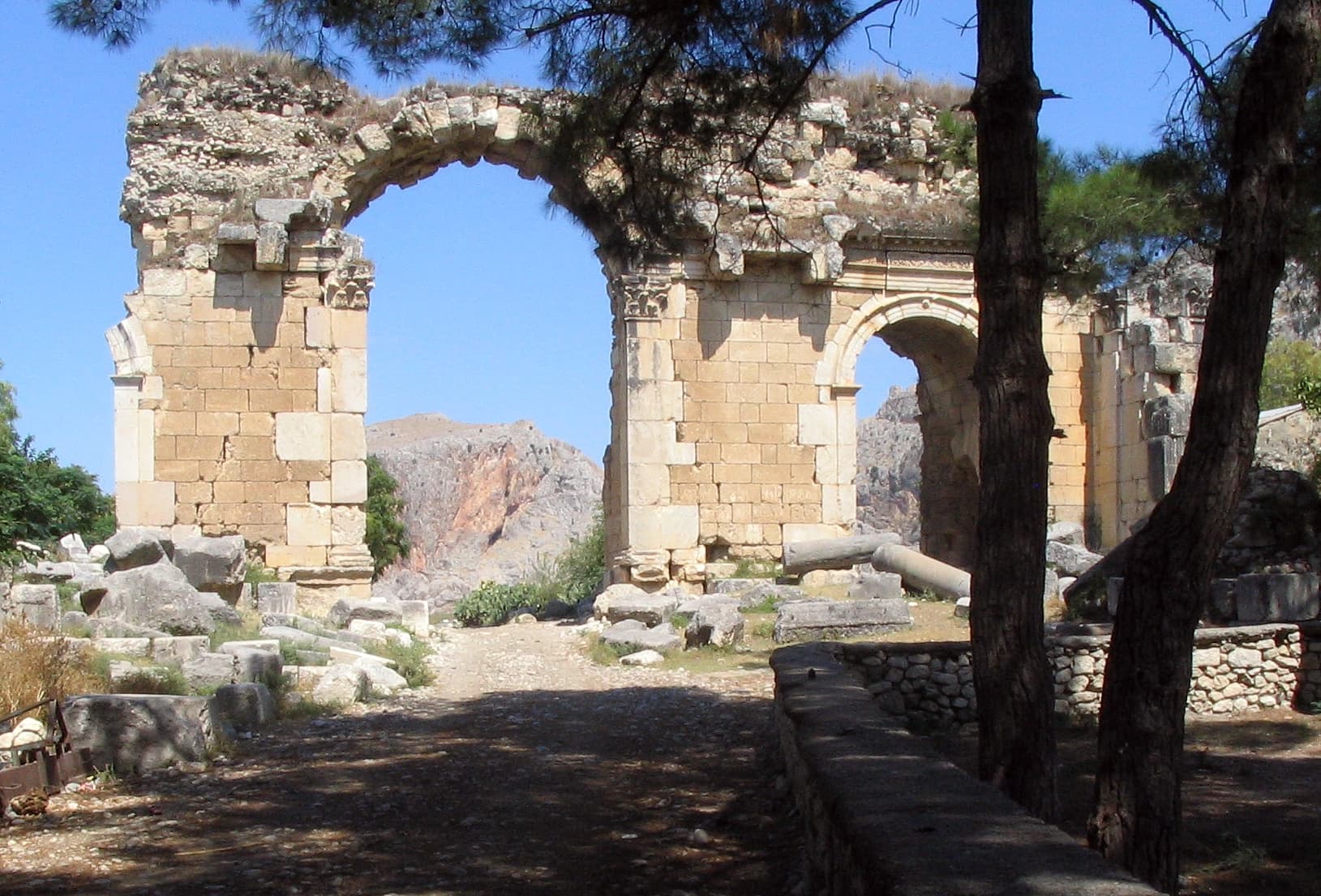
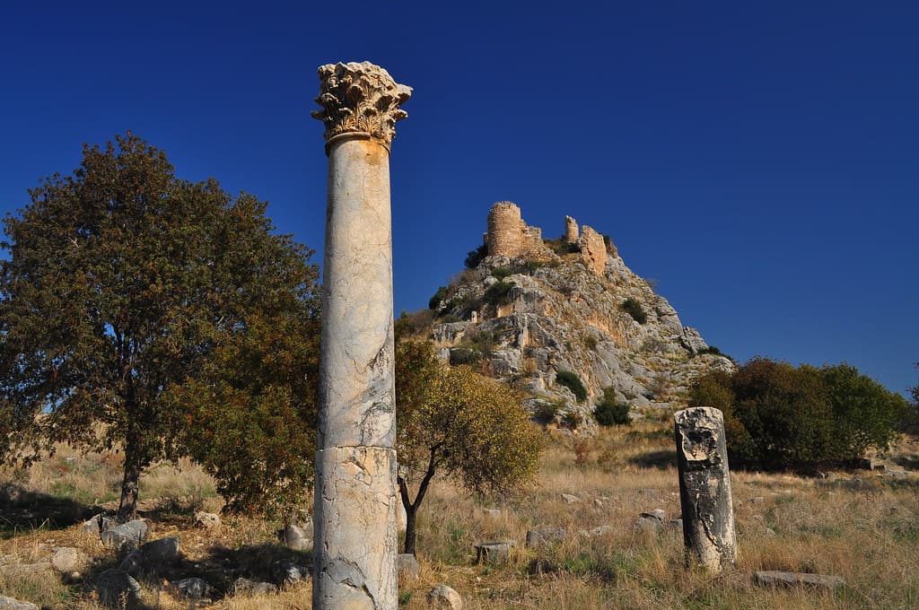
To walk Anazarbus now is to walk something larger than most ancient cities offer. The colonnaded cardo maximus stretches for 2,700 metres — the world's first known double-lane colonnaded road, 34 metres wide, lined with what were once hundreds of columns. The triumphal arch at the city's entrance, known locally as Alakapı (the Coloured Gate), still stands to considerable height. The theatre survives in partial form. The gladiatorial arena — excavated since 2013, one of the first such arenas found in Cilicia — was part of the city's infrastructure for the spectacles that, in Roman theology, were not merely entertainment but a form of civic worship performed in view of the gods.
Above all of this stands the Armenian fortress on the mesa. T'oros I of the Armenian Kingdom of Cilicia made Anazarbus his capital in the early 12th century, built a church to celebrate his victories, and transformed the Byzantine fortifications into an Armenian stronghold. The views from the fortress extend across the Cilician plain — the same plain where Alexander the Great passed before the Battle of Issos, where Seleucid kings organized their territorial claims, where Justinian I rebuilt and renamed the city. Anazarbus is a palimpsest of inhabitation on a geological platform that has held human presence for seven thousand years.
Context and lineage
The earliest human activity at Anazarbus dates to the Chalcolithic period — approximately 5000 BCE — a discovery made by excavations in progress. The Seleucid city that developed here in the 3rd century BCE built on this long-inhabited landscape. The name Anazarbus itself may derive from a Semitic or Anatolian place-name predating the Greek period; the Zeus Olybris cult was likely a Hellenized articulation of a local mountain deity tradition that had been present in the landscape for far longer than any Greek city.
The Roman development of the city — as Caesarea ad Anazarbum — brought it to metropolitan status under Septimius Severus in the 2nd century CE. The three grants of neokoros status indicate a city with sustained imperial favor: each neokorate required the construction of a temple to a living or deified emperor, and the accumulation of three placed Anazarbus in an elite category occupied by only a handful of Cilician cities. The city minted coins declaring itself 'First, Greatest and Most Beautiful' — a direct competitive claim against the neighboring metropolis of Tarsus, with which Anazarbus maintained a longstanding civic rivalry.
Justinian I's renaming of the city as Justinopolis in the 6th century CE indicates major rebuilding after an earthquake. The Armenian king T'oros I's selection of Anazarbus as his capital in the early 12th century brought the city to renewed prominence. The Mamluk conquest and destruction of 1374 effectively ended the city's occupied history.
Chalcolithic settlement → Seleucid foundation → Roman Caesarea ad Anazarbum (metropolis, thrice neokoros) → Byzantine Justinopolis (archbishopric) → Armenian Kingdom of Cilicia capital (T'oros I) → Mamluk destruction (1374) → Ruins; UNESCO Tentative Listing (2014); systematic excavation since 2013.
Why this place is sacred
The cult of Zeus Olybris at Anazarbus was not merely a local religious convenience. It was the foundation of a civic claim. When the Roman emperors granted the city neokoros status — the designation of official imperial temple-warden — three times, they were recognizing something that the city and its deity had already established: that Anazarbus was, in a meaningful sense, a divinely favored point in the landscape of Cilicia. The Zeus Olybris epithet, derived from a mountain sacred to the god in the region, made the deity's presence specifically local. This was not the universal Zeus of philosophy; this was the Zeus of this mountain, this plain, this city.
The theocratic quality of such mountain deity cults is consistent across the ancient Anatolian landscape. The sacred peak as divine throne, the city organized below it as the god's earthly representation, the inhabitants who mediate between human and divine through sacrifice, festival, and built form — all of this is present at Anazarbus in a form that excavation is only beginning to uncover. The Chalcolithic settlement discovered in recent digs extends human inhabitation of this mesa back to 5000 BCE, suggesting that the landscape's sacred quality predates any particular theological articulation by millennia.
The Armenian period adds a final, unexpected layer to this accumulation. T'oros I did not come to Anazarbus because of its Zeus cult; he came because its fortress position made it militarily valuable. But the church he built within the citadel repeated, in Christian terms, the same gesture: a ruler marking his sovereignty by locating sacred power at the highest defensible point of the landscape. The mountain god's throne became the Armenian king's stronghold. The sacred claim survived the replacement of every element that had originally made it.
Cilician city organized around the cult of Zeus Olybris, a locally specific mountain deity; Roman metropolis and neokoros three times; later Armenian capital and medieval fortress.
Chalcolithic settlement from c. 5000 BCE → Seleucid city foundation (3rd century BCE) → Roman Caesarea ad Anazarbum, metropolis, thrice neokoros → Justinian I rebuilding and renaming as Justinopolis → Byzantine archbishopric → Armenian capital under T'oros I (early 12th century CE) → Mamluk destruction (1374 CE) → Ruins; UNESCO Tentative List 2014; systematic excavation since 2013.
Traditions and practice
The neokoros status of Anazarbus required the maintenance of temples to living and deified emperors alongside the local cult of Zeus Olybris. This is not a contradiction: in the Roman theological framework, imperial cult worship and local deity worship were complementary rather than competing. The gladiatorial games held in the arena were similarly a form of public religious observance: the arena as sacred space where human combat became an offering to the gods and the emperor simultaneously. The cult of Zeus Olybris itself is associated with a sacred mountain in the city's territory; sacrificial rites at the mountain god's temple and public festivals organized around the city's neokoros calendar constituted the civic religious year.
None. The site is free to visit; archaeological excavations are ongoing since 2013. No ticket office or guided tour infrastructure exists.
Begin at the triumphal arch and walk the full length of the cardo maximus — all 2,700 metres. Do not try to see everything along the way on this first pass; let the scale of the road itself be the teaching. A city that built a 34-metre-wide double-lane colonnaded road nearly three kilometres long was making a statement about its own importance that the road itself embodies. When you have walked its full length, you will understand the 'First, Greatest and Most Beautiful' coins differently.
Then climb to the fortress. The view from the Armenian castle is the view from which every ruler of this city — Roman governor, Byzantine general, Armenian king — understood what they held. The Cilician plain extending to the horizon, the mountains marking the edges, the ancient city spread below: this is the perspective from which the claim to divine patronage was most legible. The mountain deity's throne, the city's fortification, the kingdom's capital — all three understandings of this height are present simultaneously from the castle walls.
Ancient Roman / Hellenistic
HistoricalAnazarbus was the cult center of Zeus Olybris/Olybreus and held neokoros (imperial temple-warden) status three times — a distinction reserved for cities with recognized imperial cult temples. Declared metropolis by Septimius Severus, the city was a major center of Roman civic and religious life in Cilicia.
Imperial cult worship; gladiatorial games in the arena; sacrificial rites to Zeus Olybris; civic festivals celebrating neokoros status.
Early Christian / Byzantine
HistoricalAnazarbus became an archbishopric under the Byzantine Empire, reflecting the city's continued regional importance in the Christian period. Justinian I renamed the city Justinopolis after rebuilding it following an earthquake.
Christian liturgy; episcopal administration; city rebuilding under imperial Christian patronage.
Armenian Christian
HistoricalUnder T'oros I of the Armenian Kingdom of Cilicia, Anazarbus was named the Armenian capital in the early 12th century. T'oros I built a three-aisle church and two smaller chapels within the fortress, creating an Armenian Christian monument at the city's highest point.
Armenian Christian liturgy; royal patronage of ecclesiastical construction; fortification of the mesa.
Archaeological / Scholarly
ActiveSystematic excavations since 2013 have revealed the world's first known double-lane colonnaded road, a gladiatorial arena, and Chalcolithic settlement layers extending back to 5000 BCE. Anazarbus is on the UNESCO Tentative World Heritage List (2014) and is increasingly recognized as one of the most significant underexplored cities of the ancient Mediterranean.
Active excavation; architectural documentation; UNESCO nomination process.
Experience and perspectives
Anazarbus rewards the visitor who arrives without expectations calibrated to a well-managed heritage site. The city is large — far larger than the fragments visible from the road suggest — and understanding its scale requires walking. The colonnaded cardo maximus, now an earthen track lined with fallen and fragmentary column drums, extends for nearly three kilometres. To walk its length is to perform the same spatial act that Roman citizens performed: moving through a monumental urban axis designed to make the city's grandeur legible from within.
The triumphal arch (Alakapı) stands near the main entrance to the site. Even in its partially damaged state, its height and proportions communicate the civic ambition that built it. Beyond it, the terrain opens into what was the main urban area — baths, the theatre's half-standing cavea, residential and commercial blocks in various states of collapse. The gladiatorial arena, identified by excavations begun in 2013, is visible as a large oval depression in the ground, its seating tiers partially traceable in the earth.
The fortress ascent is the most physically demanding and experientially rewarding element of the visit. The path to the Armenian castle follows a rocky ridge for perhaps thirty to forty minutes of genuine climbing. The effort is proportionate to the reward: the citadel commands an unobstructed view across the entire Cilician plain. On a clear day the Amanus Mountains are visible to the east. The Armenian church built by T'oros I survives within the fortress walls in identifiable form — its three-aisle plan readable in the stone courses that remain. Two smaller Armenian chapels are also present. The combination of Roman fortification, Byzantine modification, and Armenian construction creates a layered architectural record that is itself a form of history.
Local people sometimes offer informal guidance. This is worth accepting. The site has no official interpretation; a local who knows which stones belong to which period, which inscription is which, which corridor of the maze of the lower city leads somewhere worth seeing, is an irreplaceable resource.
Enter from Dilekkaya village. The triumphal arch is the first major monument. Walk the cardo maximus before ascending to the fortress — understanding the city's urban scale on the flat makes the fortress view more meaningful. The fortress path is steep; allow 30–40 minutes for the ascent. Bring water and food — there are no facilities at the site.
Anazarbus is approached through the lens of Roman civic theology and imperial religion, through the history of the Armenian Kingdom of Cilicia, and through the emerging archaeological picture of a city whose full significance is only now being established.
Systematic excavations at Anazarbus began in 2013 and have substantially expanded understanding of the city's urban layout and long settlement history. The UNESCO Tentative Listing under criteria (iii) — unique testimony to Cilician civilization — (iv) — outstanding architectural ensemble — and (vi) — association with events of universal significance — reflects an international scholarly consensus on the city's exceptional value. The cardo maximus, identified as the world's first known double-lane colonnaded road at 34 metres width, is architecturally unique. The gladiatorial arena find confirms the city's role in the Roman spectacle economy. The Chalcolithic layers, announced in recent excavation reports, potentially extend the city's significance far beyond its classical period.
The cult of Zeus Olybris/Olybreus represented a fusion of Greek theological vocabulary with an indigenous Anatolian mountain deity tradition. The city's assertion of metropolitan primacy — through its coins, its neokoros status, its civic boasts — was rooted in genuine regional prestige accumulated over centuries of being the recognized divine center of its corner of Cilicia. The Armenian community that made Anazarbus their capital in the 12th century was building on a tradition of sacred and royal authority that the site had accumulated long before any Armenian king arrived.
The mountain god cult at Anazarbus — Zeus Olybris associated with a sacred peak — connects to widespread ancient traditions of sacred summits as thrones of sky deities, from Mount Olympus to Mount Sinai to the Taurus peaks. The fortress mesa of Anazarbus itself echoes this vertical sacred geography: inhabitation at the highest defensible point of the landscape, with the plain spread below as the god's domain. The city's name Anazarbus may preserve pre-Greek theophoric elements whose meaning has been lost — the possibility that the name itself encodes a divine epithet from before the Greek cultural horizon is an intriguing open question.
The full extent of the Zeus Olybris sanctuary has not been excavated; neither its architectural plan nor the precise form of its oracle (if one existed) is documented. The Chalcolithic settlement recently identified represents an almost entirely unexplored layer of the city's history. Whether the 'of Anazarbus' in the name of Dioscorides — the ancient world's most influential botanist, whose Materia Medica served as the foundation of Western pharmacology for 1,500 years — correctly identifies his birthplace or merely his region of practice is unresolved. If genuine, it would make Anazarbus's intellectual legacy as significant as its imperial one.
Visit planning
Located near Dilekkaya village, approximately 30 km south of Kozan and 1 hour northeast of Adana city, Adana Province. Car is the only practical means of access — no public transport runs directly to the site. The road passes through agricultural land; signage is limited. No entry fee, no ticket office, no facilities. GPS approximately 37.2560°N, 35.8984°E.
Kozan, 30 km north, has guesthouse options. Adana, 1 hour southwest, has the widest range of accommodation for this region. The site has no accommodation in its immediate vicinity.
A free, open archaeological site with no managed entry; visitor conduct is self-governed; respect for active excavations and the site's scale is the primary obligation.
No formal requirements. Robust walking shoes or boots are essential for the fortress ascent and the uneven lower ruins. Sun protection and layers for the exposed hilltop are important.
Photography is permitted throughout. The scale of the site means wide-angle work is especially rewarding from the fortress.
Not applicable.
Do not disturb active excavation areas, which may be marked during field seasons. Do not remove any material — the Chalcolithic through medieval layers of the site are all archaeologically significant. No toilet facilities; plan accordingly for a 3–5 hour visit.
Nearby sacred places
Sacred places within a half-day’s reach. Pilgrims often visit them together: walk one, stay for the other.


References
Sources consulted when researching this page. Independent verification by readers is welcome.
- 01Ancient City of Anazarbos — UNESCO World Heritage Tentative List — UNESCO World Heritage Centrehigh-reliability
- 02Anazarbus — Britannica — Encyclopaedia Britannicahigh-reliability
- 03Anazarbus - Wikipedia — Wikipedia contributors
- 04Amazing Anazarbus: Digs Uncover Gladiatorial Ring, Triumphal Arch, and More — Ancient Origins — Ancient Origins
- 05First, Greatest and Most Beautiful — Sulla's Coins — Sulla's Coins (numismatic reference site)
- 06New discovery changes history of ancient city of Anazarbus in southern Turkey — Daily Sabah — Daily Sabah
- 07Anavarza: The Hidden Ancient City in Turkey's History — Memphis Tours — Memphis Tours
- 08Satellite map of Anazarbus — latitude.to — latitude.to
Key questions
What pilgrims usually ask
- Why is Anazarbus considered sacred?
- Anazarbus held Roman imperial temple-warden status three times and called itself First, Greatest and Most Beautiful. Its ruins — and a 2,700m colonnaded road —
- What should I wear at Anazarbus?
- No formal requirements. Robust walking shoes or boots are essential for the fortress ascent and the uneven lower ruins. Sun protection and layers for the exposed hilltop are important.
- Can I take photos at Anazarbus?
- Photography is permitted throughout. The scale of the site means wide-angle work is especially rewarding from the fortress.
- How long should I spend at Anazarbus?
- 3–5 hours for a full visit including the cardo maximus, triumphal arch, theatre, arena area, and the fortress ascent and descent.
- How do you visit Anazarbus?
- Located near Dilekkaya village, approximately 30 km south of Kozan and 1 hour northeast of Adana city, Adana Province. Car is the only practical means of access — no public transport runs directly to the site. The road passes through agricultural land; signage is limited. No entry fee, no ticket office, no facilities. GPS approximately 37.2560°N, 35.8984°E.
- What offerings are appropriate at Anazarbus?
- Not applicable.
- What etiquette should visitors follow at Anazarbus?
- A free, open archaeological site with no managed entry; visitor conduct is self-governed; respect for active excavations and the site's scale is the primary obligation.
- What is the history of Anazarbus?
- The earliest human activity at Anazarbus dates to the Chalcolithic period — approximately 5000 BCE — a discovery made by excavations in progress. The Seleucid city that developed here in the 3rd century BCE built on this long-inhabited landscape. The name Anazarbus itself may derive from a Semitic or Anatolian place-name predating the Greek period; the Zeus Olybris cult was likely a Hellenized articulation of a local mountain deity tradition that had been present in the landscape for far longer than any Greek city. The Roman development of the city — as Caesarea ad Anazarbum — brought it to metropolitan status under Septimius Severus in the 2nd century CE. The three grants of neokoros status indicate a city with sustained imperial favor: each neokorate required the construction of a temple to a living or deified emperor, and the accumulation of three placed Anazarbus in an elite category occupied by only a handful of Cilician cities. The city minted coins declaring itself 'First, Greatest and Most Beautiful' — a direct competitive claim against the neighboring metropolis of Tarsus, with which Anazarbus maintained a longstanding civic rivalry. Justinian I's renaming of the city as Justinopolis in the 6th century CE indicates major rebuilding after an earthquake. The Armenian king T'oros I's selection of Anazarbus as his capital in the early 12th century brought the city to renewed prominence. The Mamluk conquest and destruction of 1374 effectively ended the city's occupied history.