Trepucó
One of Menorca's largest taula sanctuaries, now part of a UNESCO site
Maó, Maó, Menorca, Spain
Plan this visit
Practical context before you go
No official visit-duration guidance is documented for Trepucó specifically; comparable open-air Talayotic sites of similar scale typically warrant a visit of 30 to 60 minutes, offered here as a general estimate rather than a sourced figure for this site.
Trepucó lies about 1 km south of Maó (Mahón), at the meeting point of the Mahón, Sant Lluís, and Es Castell municipalities, reached via the Camí de Gràcia. Free on-site parking is available. Access to the monument itself is free. The site is jointly managed by the Consell Insular de Menorca and Maó Municipality; the official contact number listed by the Menorca tourism board is +34 971 157 800. No mobile phone signal information is documented for the site at time of writing; given its proximity to Maó, unreliable coverage is unlikely but not confirmed — check with the Consell Insular de Menorca for current conditions if this matters to your visit. No seasonal closure dates are documented; check menorca.es or menorcatalayotica.info for current access arrangements before visiting.
Trepucó is a freely accessible, unstaffed open-air monument; the main etiquette concern is protecting fragile stonework, particularly around the taula.
At a glance
- Coordinates
- 39.8736, 4.2654
- Type
- Talayotic Settlement
- Suggested duration
- No official visit-duration guidance is documented for Trepucó specifically; comparable open-air Talayotic sites of similar scale typically warrant a visit of 30 to 60 minutes, offered here as a general estimate rather than a sourced figure for this site.
- Access
- Trepucó lies about 1 km south of Maó (Mahón), at the meeting point of the Mahón, Sant Lluís, and Es Castell municipalities, reached via the Camí de Gràcia. Free on-site parking is available. Access to the monument itself is free. The site is jointly managed by the Consell Insular de Menorca and Maó Municipality; the official contact number listed by the Menorca tourism board is +34 971 157 800. No mobile phone signal information is documented for the site at time of writing; given its proximity to Maó, unreliable coverage is unlikely but not confirmed — check with the Consell Insular de Menorca for current conditions if this matters to your visit. No seasonal closure dates are documented; check menorca.es or menorcatalayotica.info for current access arrangements before visiting.
Pilgrim tips
- No dress code is specified by managing authorities. Sturdy, closed footwear is advisable given uneven ancient stonework and rural terrain underfoot.
- No photography restrictions are documented; the site is an open-air public monument.
- Avoid touching or climbing on the taula and talayot stonework; the taula's rear support received a concrete reinforcement during 1930s excavation work that conservators now view with some reservation, making the structure a live conservation concern rather than a stable ruin to be handled freely.
Overview
Trepucó is one of the largest Talayotic settlements in Menorca, centered on a monumental taula sanctuary and a talayot tower more than 26 metres wide. Abandoned after the Roman conquest, it survives today as a component of the UNESCO World Heritage site Talayotic Menorca, inscribed in September 2023.
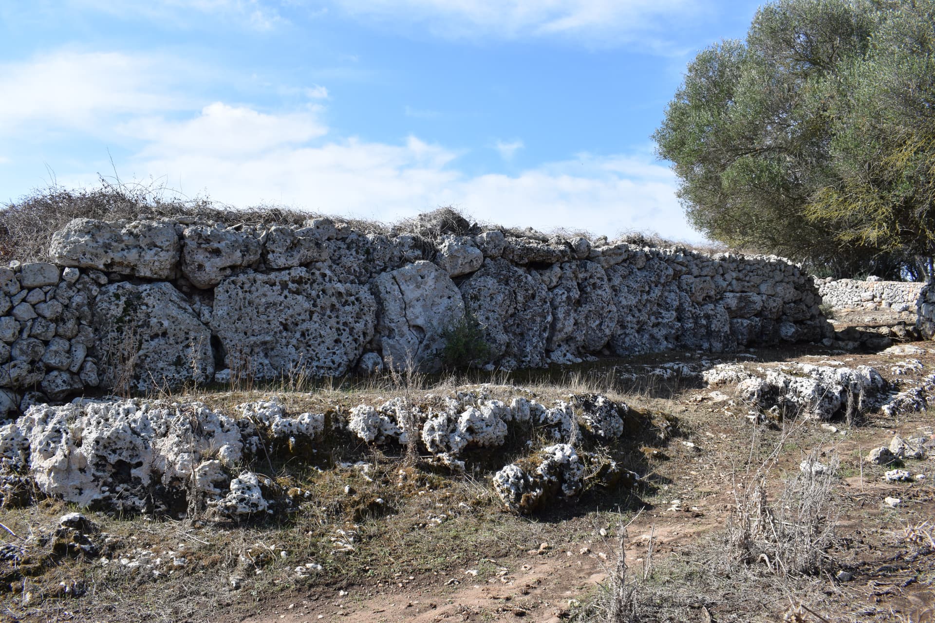
A short walk south of Maó, Trepucó occupies the boundary of three municipalities — Mahón, Sant Lluís, and Es Castell — and ranks among the largest settlements the Talayotic culture ever built on Menorca. What remains today is a fraction of a once-fortified village: stretches of a Cyclopean wall reinforced with square towers, two surviving talayots, a scatter of house foundations, and, at the site's ceremonial heart, a taula enclosure holding one of the island's tallest standing taulas. The settlement's central talayot — a truncated cone of dry-stacked stone exceeding 26 metres across and over 8 metres tall — dwarfs most other talayots on the island, and gives Trepucó a claim to have functioned as a kind of prehistoric capital for eastern Menorca. Occupation stretched from the Bronze Age into the Iron Age, likely disrupted by the Second Punic War and effectively ended with Roman annexation of the Balearics around 123 BCE. An 18th-century Spanish star fort, built over part of the main talayot during the siege of nearby Sant Felipe Castle, has left its own layer on the site — a reminder that Trepucó's stones have been repurposed by more than one era. Since September 2023, Trepucó has stood among the roughly 280 sites recognized collectively as Talayotic Menorca on the UNESCO World Heritage List.
Context and lineage
Trepucó's earliest visible talayots are dated by the Menorca tourism authority to roughly 1000–700 BCE, while carbon-dated material associated with the settlement points to occupation as early as 1300–1000 BCE. Around the 5th century BCE the community fortified the site with a Cyclopean wall reinforced by square towers, and later built up domestic quarters to the west of the ceremonial core, concentrating communal activity — talayot and taula alike — toward the settlement's center. The site's decline is tied to the Second Punic War: sources describe it as likely destroyed or disrupted between 218 and 201 BCE, a period when Hannibal's brother Magón is recorded as having based operations at nearby Port Mahón. Occupation appears to have ended with the Roman conquest of the Balearic Islands around 123 BCE, after which Trepucó was left to the landscape until an 18th-century Spanish garrison built a star-shaped fort over part of the main talayot during the 1782 siege of Sant Felipe Castle.
Trepucó belongs to the broader Talayotic culture that built settlements, taula sanctuaries, and navetas across Menorca and neighboring Mallorca; since 2023 it has been formally grouped with roughly 280 other Talayotic sites under the single UNESCO inscription Talayotic Menorca, situating it within a shared island-wide architectural and ritual tradition rather than as an isolated monument.
Margaret Murray
British archaeologist who led the 1930 excavation of Trepucó, working with Cambridge University researchers; her campaign produced findings described by contemporary sources as scientifically significant and remains the foundational excavation of the site.
Museum of Menorca (fieldwork team, 1979–1986)
Conducted later archaeological campaigns at Trepucó following Murray's initial work; no individual excavators are named in available sources for this period.
Consell Insular de Menorca
The Island Council of Menorca holds ownership and management responsibility for the central monument area and led the 2010 excavation south of the taula enclosure; jointly administers visitor access with Maó Municipality today.
Maó Municipality (Ajuntament de Maó)
Co-manages the site with the Consell Insular de Menorca, overseeing visitor infrastructure including on-site parking.
Why this place is sacred
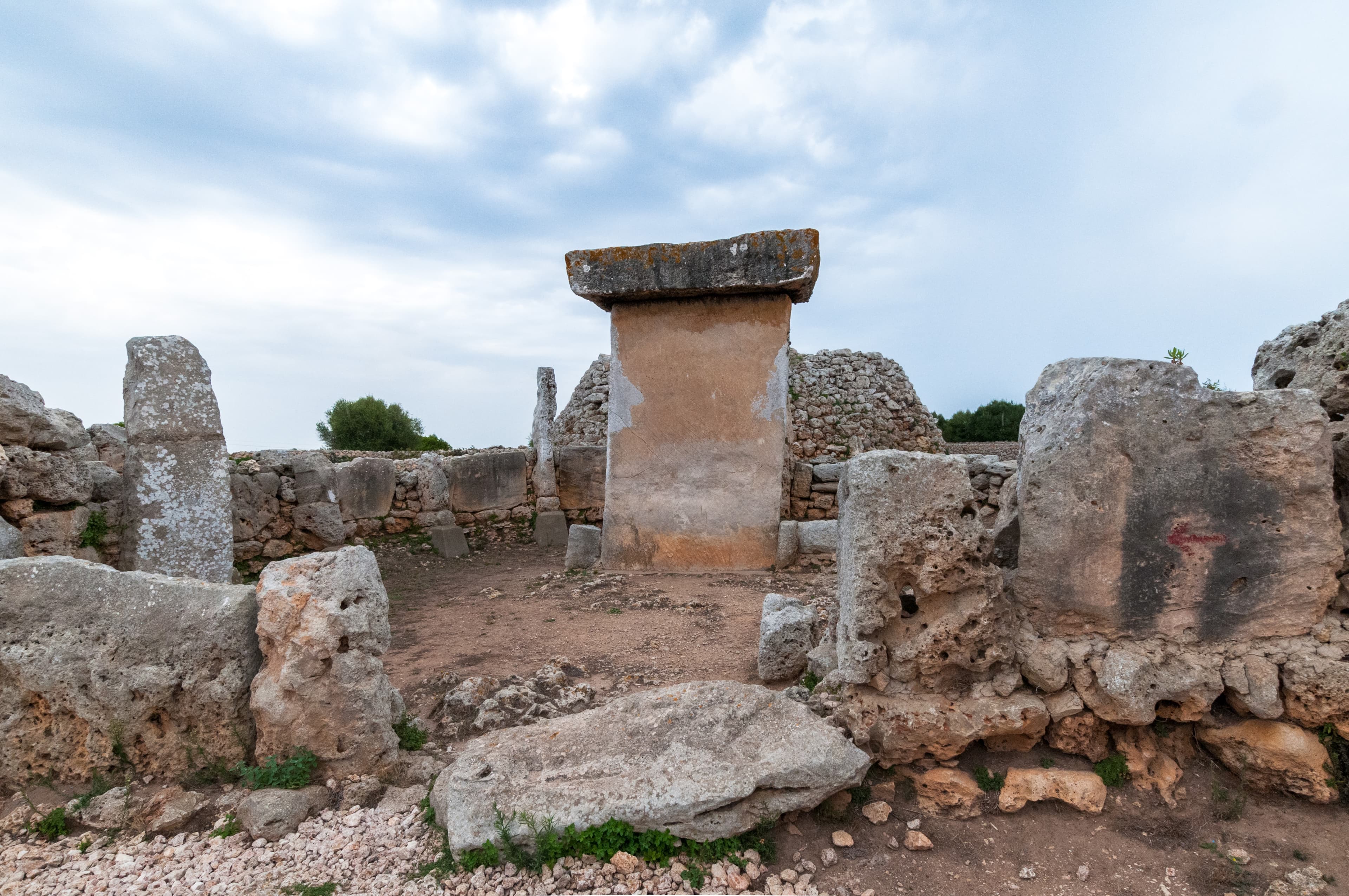
What sets a taula apart from the talayots and walls around it is its shape: two massive stones, one upright and one laid across its top, forming a T that has no functional role in supporting a roof or wall. At Trepucó the taula stands close to 4.8 metres — among the tallest documented on Menorca — and it does not stand alone in open ground. It is enclosed within a horseshoe-shaped precinct with its own double wall, a deliberate architectural gesture that separates this stone from the rest of the settlement and frames it as something to be approached rather than simply passed. The base stone of the taula was set directly into the bedrock rather than resting on a built foundation, with the capital stone balanced on top of it — a construction choice that has kept the monument standing through millennia of wind and use, and that later drew 20th-century excavators to reinforce its rear support with concrete when the structure showed signs of strain. Heritage sources describe the taula enclosures of Talayotic Menorca as settings for communal ritual — gatherings intended, in the phrasing used by local tourism authorities, to secure the favor of fate and the gods — though no Talayotic text survives to confirm what was said, sung, or offered inside that horseshoe of stone. The double wall itself is a clue worth weighing on its own terms: building two concentric walls around a ritual space, rather than one, suggests either a threshold meant to be crossed in stages or simply a structural response to holding back the weight of the enclosure's fill. Either reading is plausible; neither is confirmed. The uncertainty is real and worth sitting with: the people who built and used this taula left no writing, so what is recoverable is the architecture of their ritual, not its content.
A communal ceremonial precinct, built and used by the Talayotic settlement as its ritual center; its function is inferred from the enclosure's architecture rather than from any surviving text or unambiguous artifact assemblage.
After the settlement's decline and Roman-era abandonment, Trepucó's stones went untouched as an inhabited site for centuries, then partially overlaid in 1782 by a Spanish star-shaped fortification built during the siege of Sant Felipe Castle. The 20th century brought its second major transformation: excavation, partial reconstruction (including a concrete reinforcement added to the taula's rear support during 1930s work, a decision now viewed by conservators with some reservation), and eventual designation as a Spanish National Historical Monument in 1931. The most recent shift is administrative and symbolic rather than physical — inclusion, from September 2023, as a named component of the UNESCO World Heritage Site Talayotic Menorca.
Traditions and practice
The taula enclosure's horseshoe-shaped, double-walled form indicates it was built to hold communal gatherings distinct from ordinary settlement life, though the specific content of Talayotic ritual — words spoken, offerings made, who could enter — is not recoverable from the surviving archaeological or documentary record.
No ceremonial use of the site continues today. Trepucó's living activity is archaeological and custodial: periodic excavation campaigns (most recently in 2010), ongoing conservation of the taula and talayots, and interpretive management by the Consell Insular de Menorca and Maó Municipality, alongside its new role as a formally recognized component of a UNESCO World Heritage Site.
Walk the site in the order its builders likely intended it to be read: talayot first, its mass announcing scale and defensive purpose, then the narrower approach into the taula enclosure, where the walls themselves compress attention toward the standing stone. Pause inside the horseshoe of the enclosure rather than simply photographing the taula from outside it — the enclosure's geometry is part of what made this a ritual space, not incidental to it. Notice, too, the contrast between the two talayots: the great central tower built for mass and visibility, the smaller one built with an internal corridor meant to be entered and climbed. Where the ground opens onto the 2010-excavated house foundations, notice the shift in scale again, from monument back to the domestic dwellings of the people who built and maintained it. A visit that moves in this order — defensive mass, ritual enclosure, domestic remains — traces something close to the settlement's own internal logic, from outer wall to ceremonial center to daily life.
Talayotic Culture
HistoricalTrepucó was a major settlement and likely ceremonial center of the Talayotic culture, the Bronze Age–Iron Age megalith-building society unique to Menorca and Mallorca; its taula enclosure and monumental talayot represent some of the largest surviving examples of this architecture on the island.
Communal gathering at the taula enclosure is inferred from its purpose-built architecture; no specific liturgy, offering, or ritual sequence is documented in surviving sources.
Heritage conservation and archaeological stewardship
ActiveTrepucó remains an active site of archaeological and conservation work, from Margaret Murray's founding 1930 excavation through Museum of Menorca campaigns in the 1980s and a 2010 excavation, to its current joint management and UNESCO World Heritage status as of September 2023.
Ongoing conservation of the taula and talayot structures, periodic excavation campaigns, and interpretive management by the Consell Insular de Menorca and Maó Municipality.
Experience and perspectives
The approach to Trepucó is unhurried by design — a short walk from a parking area along the Camí de Gràcia, through farmland on the edge of Maó, with little to announce the site until the wall lines and the bulk of the main talayot resolve out of the landscape. That talayot is the first thing to register: a truncated cone over 26 metres across and more than 8 metres high, its scale closer to a small hill than a tower, its dry-stacked stone weathered but still legible as deliberate construction rather than natural outcrop. An 18th-century star fort wraps part of this same talayot, so the first visual impression is layered — prehistoric mass under early-modern military geometry, two defensive logics from different millennia occupying the same footprint. Moving south from the talayot, the taula enclosure changes the register entirely. Where the talayot reads as bulk, the taula reads as line: a single upright stone topped by another laid flat, standing within a horseshoe-shaped double wall that narrows the visitor's field of view and orients attention toward the stone rather than the surrounding fields. A second, smaller talayot lies elsewhere on the grounds, distinguished from the great central tower by an internal corridor that climbs toward its top — a feature the main talayot does not share, and one that invites a slower, more physical kind of attention: ducking into a passage built to be walked through rather than simply viewed. Walking the full circuit of what survives — wall fragments with their square defensive towers, the second talayot's corridor, and the scattered foundations of three talayotic houses uncovered in a 2010 excavation south of the enclosure — takes the site from monument to settlement, making clear that the taula and the great talayot were never freestanding curiosities but the ceremonial and defensive anchors of a working village whose ordinary dwellings have only partly resurfaced.
Enter from the Camí de Gràcia parking area; the main talayot and its overlaid star fort are the first structures encountered, with the taula enclosure a short walk south. The second talayot and the 2010-excavated house remains lie further into the site.
Trepucó is read differently depending on the lens brought to it — as archaeological evidence of Talayotic social organization, as a case study in the ethics of early-20th-century excavation and reconstruction, and as a site whose deepest question, the meaning of taula ritual, remains genuinely unanswered. None of these lenses cancels the others; a visitor can hold the site as a monument to skilled Bronze Age engineering, a reminder of how conservation practice has itself evolved since Margaret Murray's day, and an open question about a lost belief system, all at once.
Heritage-management sources treat Trepucó as one of the largest and most architecturally significant Talayotic settlements in eastern Menorca, its scale — the 26-metre-plus talayot, the nearly 5-metre taula, the Cyclopean fortification wall — read as evidence of a hierarchical, ritually organized society capable of mobilizing substantial communal labor over generations. The clustering of communal structures (talayot and taula) toward the settlement's center, with domestic quarters concentrated to the west, is cited as evidence of deliberate spatial planning rather than organic, unplanned growth. The site's likely disruption during the Second Punic War and abandonment after Roman annexation is described with appropriate hedging ('probably destroyed') rather than treated as settled fact, and the 1930s conservation intervention — particularly the concrete reinforcement added to the taula — is now viewed by heritage authorities themselves as a case study in the limits of early-20th-century restoration practice.
No continuous indigenous or traditional community associated with Talayotic culture survives; the culture is known today only through archaeology, so no living traditional perspective can be offered on the site's original meaning.
No esoteric or alternative-spirituality literature specific to Trepucó was found in available research; this content does not assert any such framing.
The central mystery is what actually happened inside the taula enclosure — what was said, offered, or enacted there, and what cosmology (if any) the T-shaped form was meant to embody. No Talayotic text survives to answer this, and heritage sources are candid that the ritual content of taula worship cannot be reconstructed from the architecture and artifacts alone. A secondary open question is the precise circumstances of the settlement's Second Punic War-era disruption, described in sources with explicit qualification rather than certainty.
Visit planning
Trepucó lies about 1 km south of Maó (Mahón), at the meeting point of the Mahón, Sant Lluís, and Es Castell municipalities, reached via the Camí de Gràcia. Free on-site parking is available. Access to the monument itself is free. The site is jointly managed by the Consell Insular de Menorca and Maó Municipality; the official contact number listed by the Menorca tourism board is +34 971 157 800. No mobile phone signal information is documented for the site at time of writing; given its proximity to Maó, unreliable coverage is unlikely but not confirmed — check with the Consell Insular de Menorca for current conditions if this matters to your visit. No seasonal closure dates are documented; check menorca.es or menorcatalayotica.info for current access arrangements before visiting.
No accommodation information specific to Trepucó is documented in available sources; the site's proximity to Maó places it within reach of that town's standard visitor lodging.
Trepucó is a freely accessible, unstaffed open-air monument; the main etiquette concern is protecting fragile stonework, particularly around the taula.
No dress code is specified by managing authorities. Sturdy, closed footwear is advisable given uneven ancient stonework and rural terrain underfoot.
No photography restrictions are documented; the site is an open-air public monument.
Not applicable — no active devotional or offering practice is associated with the site today.
Visitors should stay on marked paths and refrain from climbing on or touching the megalithic stonework, especially around the taula enclosure, where a mid-20th-century concrete reinforcement of the taula's rear support is flagged in heritage sources as an ongoing conservation concern.
Nearby sacred places
Sacred places within a half-day’s reach. Pilgrims often visit them together: walk one, stay for the other.


References
Sources consulted when researching this page. Independent verification by readers is welcome.
- 01Trepucó talayotic settlement — Menorca.es (official Menorca tourism board) — Consell Insular de Menorca / Fundació Foment del Turismehigh-reliability
- 02Trepucó Talayotic Settlement — visitor/management details — Consell Insular de Menorca / Ajuntament de Maóhigh-reliability
- 03Archaeological Site Taula i Talaiot de Trepucó — Illes Balears Travel (official Balearic Islands tourism board) — Agència de Turisme de les Illes Balearshigh-reliability
- 04Talayotic Settlement of Trepucó — Menorca Talaiòtica (heritage/interpretive network) — Consell Insular de Menorca — Menorca Talaiòtica interpretive networkhigh-reliability
- 05Talayotic Menorca — UNESCO World Heritage Centre — UNESCO World Heritage Centrehigh-reliability
- 06Discover Menorca Talayotic: New UNESCO World Heritage Site — ARTIEM Hotels — ARTIEM Hotels
- 07Exploring The Talayotic Settlement Of Trepucó In Menorca — Portal Menorca — Portal Menorca
- 08Trepucó — Megalithic monuments of Menorca — Descobreix Menorca — Descobreix Menorca (official Menorca destination content)
- 09Talayot de Trepuco, Mahon, Minorca, Balearics — The Journal Of Antiquities — The Journal Of Antiquities (independent heritage blog)
Key questions
What pilgrims usually ask
- Why is Trepucó considered sacred?
- Stand before one of Menorca's tallest taulas at Trepucó, a UNESCO-listed Talayotic settlement near Maó with a 26-metre talayot and Cyclopean walls.
- What should I wear at Trepucó?
- No dress code is specified by managing authorities. Sturdy, closed footwear is advisable given uneven ancient stonework and rural terrain underfoot.
- Can I take photos at Trepucó?
- No photography restrictions are documented; the site is an open-air public monument.
- How long should I spend at Trepucó?
- No official visit-duration guidance is documented for Trepucó specifically; comparable open-air Talayotic sites of similar scale typically warrant a visit of 30 to 60 minutes, offered here as a general estimate rather than a sourced figure for this site.
- How do you visit Trepucó?
- Trepucó lies about 1 km south of Maó (Mahón), at the meeting point of the Mahón, Sant Lluís, and Es Castell municipalities, reached via the Camí de Gràcia. Free on-site parking is available. Access to the monument itself is free. The site is jointly managed by the Consell Insular de Menorca and Maó Municipality; the official contact number listed by the Menorca tourism board is +34 971 157 800. No mobile phone signal information is documented for the site at time of writing; given its proximity to Maó, unreliable coverage is unlikely but not confirmed — check with the Consell Insular de Menorca for current conditions if this matters to your visit. No seasonal closure dates are documented; check menorca.es or menorcatalayotica.info for current access arrangements before visiting.
- What offerings are appropriate at Trepucó?
- Not applicable — no active devotional or offering practice is associated with the site today.
- What etiquette should visitors follow at Trepucó?
- Trepucó is a freely accessible, unstaffed open-air monument; the main etiquette concern is protecting fragile stonework, particularly around the taula.
- What is the history of Trepucó?
- Trepucó's earliest visible talayots are dated by the Menorca tourism authority to roughly 1000–700 BCE, while carbon-dated material associated with the settlement points to occupation as early as 1300–1000 BCE. Around the 5th century BCE the community fortified the site with a Cyclopean wall reinforced by square towers, and later built up domestic quarters to the west of the ceremonial core, concentrating communal activity — talayot and taula alike — toward the settlement's center. The site's decline is tied to the Second Punic War: sources describe it as likely destroyed or disrupted between 218 and 201 BCE, a period when Hannibal's brother Magón is recorded as having based operations at nearby Port Mahón. Occupation appears to have ended with the Roman conquest of the Balearic Islands around 123 BCE, after which Trepucó was left to the landscape until an 18th-century Spanish garrison built a star-shaped fort over part of the main talayot during the 1782 siege of Sant Felipe Castle.