Tilmen Höyük
A sunrise-oriented Bronze Age shrine and Storm God temple in a Ramsar wetland valley — five thousand years of sacred life in southeastern Turkey
Gaziantep, İslahiye, Turkey

Plan this visit
Practical context before you go
1 to 2 hours including the natural landscape; allow extra time in spring for birdwatching along the Karasu River.
Located 10 km east of Islahiye, Gaziantep Province, on the road to Kuzucu village. Brown tourist signs from Islahiye (6 km from the town outskirts) indicate the turn. Best reached by private car; taxi from Islahiye recommended (agree return fare and waiting time). From Gaziantep city: approximately 90 km via D400 (allow 75 minutes). Admission free. Open during daylight hours; no formal closing time. No café or facilities at the site — bring water and food. Mobile signal is intermittent; download offline maps before arriving. Can be combined with Yesemek (23 km from Islahiye) and Zincirli (c. 15–20 km) for a full day itinerary in the Islahiye valley.
A quiet, accessible site within a protected natural environment — respect both the archaeological remains and the ecological integrity of the surrounding Ramsar wetland.
At a glance
- Coordinates
- 37.0300, 36.7040
- Type
- Bronze Age Tell
- Suggested duration
- 1 to 2 hours including the natural landscape; allow extra time in spring for birdwatching along the Karasu River.
- Access
- Located 10 km east of Islahiye, Gaziantep Province, on the road to Kuzucu village. Brown tourist signs from Islahiye (6 km from the town outskirts) indicate the turn. Best reached by private car; taxi from Islahiye recommended (agree return fare and waiting time). From Gaziantep city: approximately 90 km via D400 (allow 75 minutes). Admission free. Open during daylight hours; no formal closing time. No café or facilities at the site — bring water and food. Mobile signal is intermittent; download offline maps before arriving. Can be combined with Yesemek (23 km from Islahiye) and Zincirli (c. 15–20 km) for a full day itinerary in the Islahiye valley.
Pilgrim tips
- No religious dress requirements. Practical outdoor clothing for a rural, potentially wet site. Waterproof footwear recommended in wet seasons. Insect repellent advisable in summer.
- Permitted throughout the site. The wetland landscape, bird life, and mound setting offer excellent photographic opportunities beyond the archaeological structures themselves.
- The path may be muddy after rain; appropriate waterproof footwear is recommended, especially in spring. The wetland surroundings mean biting insects are active in summer; bring repellent. No facilities at the site; carry water and food. Mobile signal is limited in this area.
Overview
Tilmen Höyük is a Bronze Age tell mound near Islahiye in southeastern Turkey, set within a Ramsar-protected wetland valley. Its earliest sacred structure — a 5,000-year-old shrine with a clay horn altar oriented toward the sunrise — marks one of the most ancient institutionalized religious sites in the region. Above it, a Middle Bronze Age temple to the Storm God preserved a basalt stele depicting a worshipper before the divine. The site's beauty and bird-rich setting add a living dimension to its deep sacred history.
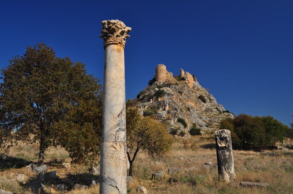
Ten kilometres east of Islahiye, where the Karasu River cuts through a valley between the Anti-Taurus foothills and the Syrian plain, a mound rises 21 metres above the wetland landscape. Tilmen Höyük has been occupied since the 4th millennium BCE, and the people who returned to this place across four thousand years shared at least one characteristic with the first settlers: they built their sacred structures facing east, toward sunrise.
The earliest shrine at Tilmen Höyük dates to approximately 3025–2875 BCE, in the Early Bronze Age. It stands at the center of the mound on a mudbrick platform, and it is oriented toward the east — deliberately, consistently, toward the rising sun. The altar within it is a clay horn altar, one of the most ancient forms of sacred object documented in the ancient Near East, with counterparts across the region from Mesopotamia to the Levant. The presence of infant burials near the shrine suggests additional ritual layers, possibly connected to fertility or rebirth.
Several centuries later, Tilmen Höyük reached its peak as a Middle Bronze Age city of the 18th to 17th centuries BCE. The city was substantial — 225 metres across, fortified with walls and gates, organized into an Upper Town and a Lower Town. At the center of the Upper Town stood a monumental temple with twin-towered facade, a form of sacred architecture that echoes across the ancient Near East from the same period. Inside, a basalt stele carved in late Old Syrian style showed a high official in a posture of prayer before what researchers interpret as the Storm God — Hadad, Ba'al, the divine master of weather, rain, and agricultural fertility.
The Storm God was not a minor deity in this region. He was the supreme figure of the Syro-Anatolian religious world, the divine force on whose favor the survival of farming communities depended. The stele at Tilmen Höyük documents the religious politics of a city that understood itself as being under his specific protection.
Today the site sits within a protected wetland ecosystem. Grey wagtails and pied kingfishers inhabit the Karasu River. The prepared visitor path with informational panels makes the archaeology accessible. The landscape around the mound is one of the most beautiful settings for an ancient site in this part of Turkey.
Context and lineage
Settlement at Tilmen Höyük began in the 4th millennium BCE, in the late Chalcolithic transition to Early Bronze Age, when the Islahiye valley corridor connecting Mesopotamia and Anatolia was already an established route for movement and exchange. The first sacred structure — a mudbrick platform with clay horn altar, oriented east — dates to approximately 3025–2875 BCE. The presence of infant burials in nearby pits may reflect fertility or rebirth ritual associated with the earliest cult.
The city reached its greatest extent and sophistication in the Middle Bronze Age II, around the 18th to 17th centuries BCE. During this period, Tilmen Höyük is probably identical with the city referred to in textual sources as Zalbar or Zalwar — a city connected to Old Babylonian trading networks that linked the Middle Euphrates with Cilicia. A Babylonian official stationed here during the reign of King Sumu-la-el of Babylon (c. 1880–1845 BCE) is documented in the academic literature, confirming the site's integration into a wider commercial and political world.
The Upper Town monumental temple, with its twin-towered facade and basalt Storm God stele, belongs to this peak phase. The stele depicts a high official in a prayer posture before the deity, carved in a style recognizably related to contemporary Old Syrian religious art across northern Syria and southeastern Anatolia. The Storm God tradition this stele represents was the dominant religious force across the entire Syro-Anatolian sphere of the 2nd millennium BCE.
Late Chalcolithic / Early Bronze Age settlement (4th millennium BCE) → Early Bronze Age I sunrise shrine (c. 3025–2875 BCE) → Middle Bronze Age II monumental city and Storm God temple (18th–17th centuries BCE) → Old Babylonian trading connections (c. 1880–1500 BCE) → Late Bronze Age decline → Modern excavation (1959–1972; 2003–2008) → Prepared visitor site
Prof. Uluğ Bahadır Alkım
Turkish archaeologist, Istanbul University
N. Marchetti
Italian co-director
Why this place is sacred
The word 'orientation' comes from the Latin oriens, the rising sun. To orient something is to face it east, toward where the day begins. The earliest shrine at Tilmen Höyük was oriented, in this original sense. The builders who placed a horn altar on a mudbrick platform and positioned it to face the sunrise were doing something that communities across the ancient Near East did with remarkable consistency: they were locating their sacred space in relationship to the sky's most dependable event.
The Middle Bronze Age Storm God temple that followed, with its twin-towered facade and its carved stele of a worshipper in prayer, represents a different but related theological logic. The Storm God was not identified with the sun but with the weather — with the visible drama of divine power in rain, thunder, and the cloud-covered sky. Yet the site that housed his temple was the same site that had been oriented toward sunrise for a thousand years before him.
This persistence — the same mound, the same orientation, different names for the sacred — is what makes Tilmen Höyük a thin place in the contemplative sense. It is a location that humans across four millennia found worth returning to, worth consecrating, worth building on again when the previous city's stones had settled. The theological explanation for this persistence is unknown. The geographical one — water, fertile land, a well-positioned hill in a productive valley — is clear. But geography does not by itself produce a horn altar facing the sunrise. Something else was at work.
Traditions and practice
The clay horn altar of the Early Bronze Age shrine at Tilmen Höyük belongs to one of the most ancient families of sacred object in the Near East. Horn altars appear consistently across the region — in Mesopotamian temples, in Canaanite sacred sites, in later Israelite religious architecture, where the 'horns of the altar' are mentioned repeatedly in the Hebrew Bible as places of refuge. The specific practice at Tilmen Höyük's earliest shrine is unknown, but the altar's east-facing orientation toward sunrise suggests a cultic attention to the daily renewal of light.
The Middle Bronze Age Storm God temple represented a more institutionalized form of religious practice. A monumental twin-towered facade announced the sacred character of the structure from a distance. Inside, the basalt stele of a high official praying before the Storm God served as a permanent liturgical object — a material expression of the relationship between human authority and divine power. The Storm God's favor meant rain, successful harvests, and the continuation of the agricultural cycle; his displeasure meant drought and famine. The temple's function was to maintain this relationship through regular worship.
No active religious practices. The site is managed as a heritage tourism destination within the Ramsar-protected wetland area.
Arrive in the first hour after sunrise. The east-facing orientation of the earliest shrine, now 5,000 years old, was designed for this light. You cannot stand in the original shrine — it is excavated and partially preserved under the visitor path — but you can stand on the mound summit as the sun clears the eastern hills and let the orientation register in your body before it registers in your mind.
The horn altar is gone. The Storm God stele is in a museum. What remains is the site's spatial logic and its natural setting. Walk to the river edge if the path permits and watch the Karasu for birds. The kingfishers and wagtails that work this stretch of river have no interest in the Bronze Age; they are simply doing what birds do at water. The combination — ancient sacred intention, living ecosystem, the continuity of water in this valley — offers a contemplation that no monument alone can provide.
Note the shape of the mound: 225 metres across, clearly artificial, rising above the surrounding wetland. Bronze Age people built this. They moved this much earth over this much time for reasons that included the sacred. The scale of that effort is part of what the site preserves.
Early Bronze Age Shrine Cult
HistoricalThe earliest shrine at Tilmen Höyük (c. 3025–2875 BCE) was positioned at the center of the tell on a mudbrick platform with a clay horn altar, oriented toward the east — toward sunrise. This is one of the earliest known institutionalized sacred structures in the Islahiye valley and documents a solar or cosmological religious orientation that predates the city's peak by over a millennium.
Horn altar rituals; probable solar-oriented worship; infant burial rites possibly connected to fertility or rebirth concepts.
Bronze Age Storm God Worship
HistoricalThe Middle Bronze Age II temple (18th–17th centuries BCE) with twin-towered facade contained a basalt stele in Old Syrian style depicting a worshipper before the Storm God. This links Tilmen Höyük to the dominant religious tradition across Syro-Anatolian Bronze Age civilization — a deity whose theological descendants include Canaanite Ba'al and the Aramaic Hadad.
Storm God worship through temple ritual; official prayer represented in votive stelae; probable seasonal festivals related to rain and agricultural fertility.
Archaeological / Scholarly
ActiveExcavated initially by Istanbul University (1959–1972) and subsequently by a joint Turco-Italian team (2003–2008), producing two major published excavation volumes. The site is preserved with a prepared visitor path and informational panels, making it accessible within the context of the Ramsar-protected wetland.
Archaeological excavation and publication; heritage site management; visitor interpretation through informational panels.
Experience and perspectives
Tilmen Höyük is one of the more accessible sites in the Islahiye valley cluster. The prepared visitor path with illustrated information boards in Turkish makes the archaeological structures legible even without a guide. Brown tourist signs from Islahiye (6 km) lead to the entrance.
The mound itself is substantial: 225 metres in diameter and 21 metres high, it commands a clear view of the Karasu River valley and the wetlands that surround it. The Ramsar-protected status of the surrounding area means the ecological environment is actively managed; the combination of ancient archaeology and protected natural habitat is unusual even in Turkey.
The bird life is part of the visit. Grey wagtails work the river margins with characteristic bobbing energy. Pied kingfishers hover over the water in the pointed, suspended way that makes them unforgettable. In spring, the wetlands attract additional migratory species. The presence of wildlife in an active ecosystem around a Bronze Age sacred site gives the visit a quality that more developed archaeological parks cannot replicate.
The excavated areas include sections of the Upper Town fortification walls and the temple foundation area, where the twin-towered facade has been partially reconstructed in section. The horn altar and the Storm God stele are not in situ — the stele is in a museum collection — but the site's spatial organization is enough to communicate the logic of the ancient city: walled, hierarchical, with the sacred at its elevated center.
Enter from the road south of Islahiye following brown tourist signs. Park at the entrance and take the prepared path. The circuit of the main mound takes approximately one hour. Allow extra time in spring to observe the wetland birds along the Karasu.
Tilmen Höyük raises a question that its evidence cannot answer: why did successive cultures return to this specific mound across four millennia to build their sacred structures? The geographical advantages are real but not unique; the persistent return suggests something more than pragmatism.
Tilmen Höyük is recognized as a significant Bronze Age site documenting urban development and religious architecture in the strategic Islahiye corridor between Mesopotamia and Anatolia. Two major excavation volumes published through the Shelby White and Leon Levy Program (Harvard) confirm its scholarly importance. The Old Babylonian trading connection documented at the site places it within the wider commercial and cultural network of the early 2nd millennium BCE. The Storm God stele is recognized as an important example of Old Syrian religious art.
No living religious tradition is directly connected to the site. Turkish state heritage management oversees the site within the Gaziantep provincial heritage framework.
The site's east-facing sunrise orientation has attracted attention from researchers interested in ancient solar religion and sacred landscape alignment in the Near East. The horn altar form — one of the oldest continuously attested sacred objects in the ancient Near East — connects Tilmen Höyük to a family of ritual practice that extends forward in time through Canaanite and Israelite religion, where the 'horns of the altar' retain their significance for several more millennia.
The definitive identification of the site with ancient Zalbar or Zalwar remains probable but not confirmed. The full religious program of the Middle Bronze Age temple — what rituals were performed, on what calendar, by which priests — awaits further epigraphic confirmation. The meaning of the infant burials near the Early Bronze Age shrine is contested; interpretations range from foundation deposits to dedicated cult burials to other purposes. Large portions of the 4.5-hectare site remain unexcavated.
Visit planning
Located 10 km east of Islahiye, Gaziantep Province, on the road to Kuzucu village. Brown tourist signs from Islahiye (6 km from the town outskirts) indicate the turn. Best reached by private car; taxi from Islahiye recommended (agree return fare and waiting time). From Gaziantep city: approximately 90 km via D400 (allow 75 minutes). Admission free. Open during daylight hours; no formal closing time. No café or facilities at the site — bring water and food. Mobile signal is intermittent; download offline maps before arriving. Can be combined with Yesemek (23 km from Islahiye) and Zincirli (c. 15–20 km) for a full day itinerary in the Islahiye valley.
Islahiye (10 km west) has basic accommodation options. Gaziantep (90 km) is the preferred base for this cluster of sites, offering comfortable hotels, excellent food, and the regional archaeological museum.
A quiet, accessible site within a protected natural environment — respect both the archaeological remains and the ecological integrity of the surrounding Ramsar wetland.
No religious dress requirements. Practical outdoor clothing for a rural, potentially wet site. Waterproof footwear recommended in wet seasons. Insect repellent advisable in summer.
Permitted throughout the site. The wetland landscape, bird life, and mound setting offer excellent photographic opportunities beyond the archaeological structures themselves.
Not applicable; no active religious tradition.
Stay on the designated visitor path. Do not disturb the archaeological structures or excavated areas. Do not remove any material from the site. Respect the Ramsar wetland environment — do not disturb wildlife or enter restricted natural areas.
Nearby sacred places
Sacred places within a half-day’s reach. Pilgrims often visit them together: walk one, stay for the other.


References
Sources consulted when researching this page. Independent verification by readers is welcome.
- 01Tilmen Höyük — OrientLab, University of Bolognahigh-reliability
- 02Tilmen Höyük — CRANE Project, University of Torontohigh-reliability
- 03Excavations at Tilmen Höyük I: The Fortification System in the Lower Town — Shelby White and Leon Levy Program for Archaeological Publicationshigh-reliability
- 04Tilmen Höyük II – The Excavations in the Upper Town — Shelby White and Leon Levy Program, Harvardhigh-reliability
- 05A Babylonian Official at Tilmen Höyuk in the Time of King Sumu-la-el of Babylon — Academic authors, Academia.eduhigh-reliability
- 06Tilmen Hoyuk - Wikipedia — Wikipedia contributors
- 07Tilmen Höyük | Turkish Archaeological News — Turkish Archaeological News
- 08Yesemek, Tilmen, and Zincirli Hittite Archaeological Sites — Art of Wayfaring
Key questions
What pilgrims usually ask
- Why is Tilmen Höyük considered sacred?
- Tilmen Höyük near Islahiye holds a 5,000-year-old sunrise shrine and Bronze Age Storm God temple, set in a Ramsar wetland — among the oldest sacred sites in sou
- What should I wear at Tilmen Höyük?
- No religious dress requirements. Practical outdoor clothing for a rural, potentially wet site. Waterproof footwear recommended in wet seasons. Insect repellent advisable in summer.
- Can I take photos at Tilmen Höyük?
- Permitted throughout the site. The wetland landscape, bird life, and mound setting offer excellent photographic opportunities beyond the archaeological structures themselves.
- How long should I spend at Tilmen Höyük?
- 1 to 2 hours including the natural landscape; allow extra time in spring for birdwatching along the Karasu River.
- How do you visit Tilmen Höyük?
- Located 10 km east of Islahiye, Gaziantep Province, on the road to Kuzucu village. Brown tourist signs from Islahiye (6 km from the town outskirts) indicate the turn. Best reached by private car; taxi from Islahiye recommended (agree return fare and waiting time). From Gaziantep city: approximately 90 km via D400 (allow 75 minutes). Admission free. Open during daylight hours; no formal closing time. No café or facilities at the site — bring water and food. Mobile signal is intermittent; download offline maps before arriving. Can be combined with Yesemek (23 km from Islahiye) and Zincirli (c. 15–20 km) for a full day itinerary in the Islahiye valley.
- What offerings are appropriate at Tilmen Höyük?
- Not applicable; no active religious tradition.
- What etiquette should visitors follow at Tilmen Höyük?
- A quiet, accessible site within a protected natural environment — respect both the archaeological remains and the ecological integrity of the surrounding Ramsar wetland.
- What is the history of Tilmen Höyük?
- Settlement at Tilmen Höyük began in the 4th millennium BCE, in the late Chalcolithic transition to Early Bronze Age, when the Islahiye valley corridor connecting Mesopotamia and Anatolia was already an established route for movement and exchange. The first sacred structure — a mudbrick platform with clay horn altar, oriented east — dates to approximately 3025–2875 BCE. The presence of infant burials in nearby pits may reflect fertility or rebirth ritual associated with the earliest cult. The city reached its greatest extent and sophistication in the Middle Bronze Age II, around the 18th to 17th centuries BCE. During this period, Tilmen Höyük is probably identical with the city referred to in textual sources as Zalbar or Zalwar — a city connected to Old Babylonian trading networks that linked the Middle Euphrates with Cilicia. A Babylonian official stationed here during the reign of King Sumu-la-el of Babylon (c. 1880–1845 BCE) is documented in the academic literature, confirming the site's integration into a wider commercial and political world. The Upper Town monumental temple, with its twin-towered facade and basalt Storm God stele, belongs to this peak phase. The stele depicts a high official in a prayer posture before the deity, carved in a style recognizably related to contemporary Old Syrian religious art across northern Syria and southeastern Anatolia. The Storm God tradition this stele represents was the dominant religious force across the entire Syro-Anatolian sphere of the 2nd millennium BCE.