Tierradentro Pyramid
A natural stone pyramid bearing pre-Columbian carvings above and colonial tunnels below
Inza, Cauca, Colombia
Plan this visit
Practical context before you go
One to two hours including the walk from Inza and time to explore the tunnels and summit.
Located approximately thirty minutes' walk uphill from the town of Inza, Cauca Department, Colombia. Inza is accessible by bus from Popayan, approximately four hours. No public transport directly to the pyramid. Entry fee approximately 5,000 COP. No facilities at the site. Mobile phone signal may be limited on the approach and at the site; confirm availability before relying on it.
The Tierradentro Pyramid is a natural formation with archaeological features in Nasa indigenous territory. Respect the carvings, exercise caution in the tunnels, and treat the surrounding territory with the respect due to an indigenous homeland.
At a glance
- Coordinates
- 2.5800, -76.0400
- Type
- archaeological_site
- Suggested duration
- One to two hours including the walk from Inza and time to explore the tunnels and summit.
- Access
- Located approximately thirty minutes' walk uphill from the town of Inza, Cauca Department, Colombia. Inza is accessible by bus from Popayan, approximately four hours. No public transport directly to the pyramid. Entry fee approximately 5,000 COP. No facilities at the site. Mobile phone signal may be limited on the approach and at the site; confirm availability before relying on it.
Pilgrim tips
- Sturdy walking shoes for the uphill approach and potentially uneven tunnel floors.
- Photography is permitted without restriction.
- The uphill walk is moderate but sustained. Wear sturdy shoes. The tunnels are dark and may be uneven; bring a flashlight and exercise caution. The summit carvings are weathered; do not attempt to enhance or trace them. The site is within Nasa territory; behave as a respectful guest.
Overview
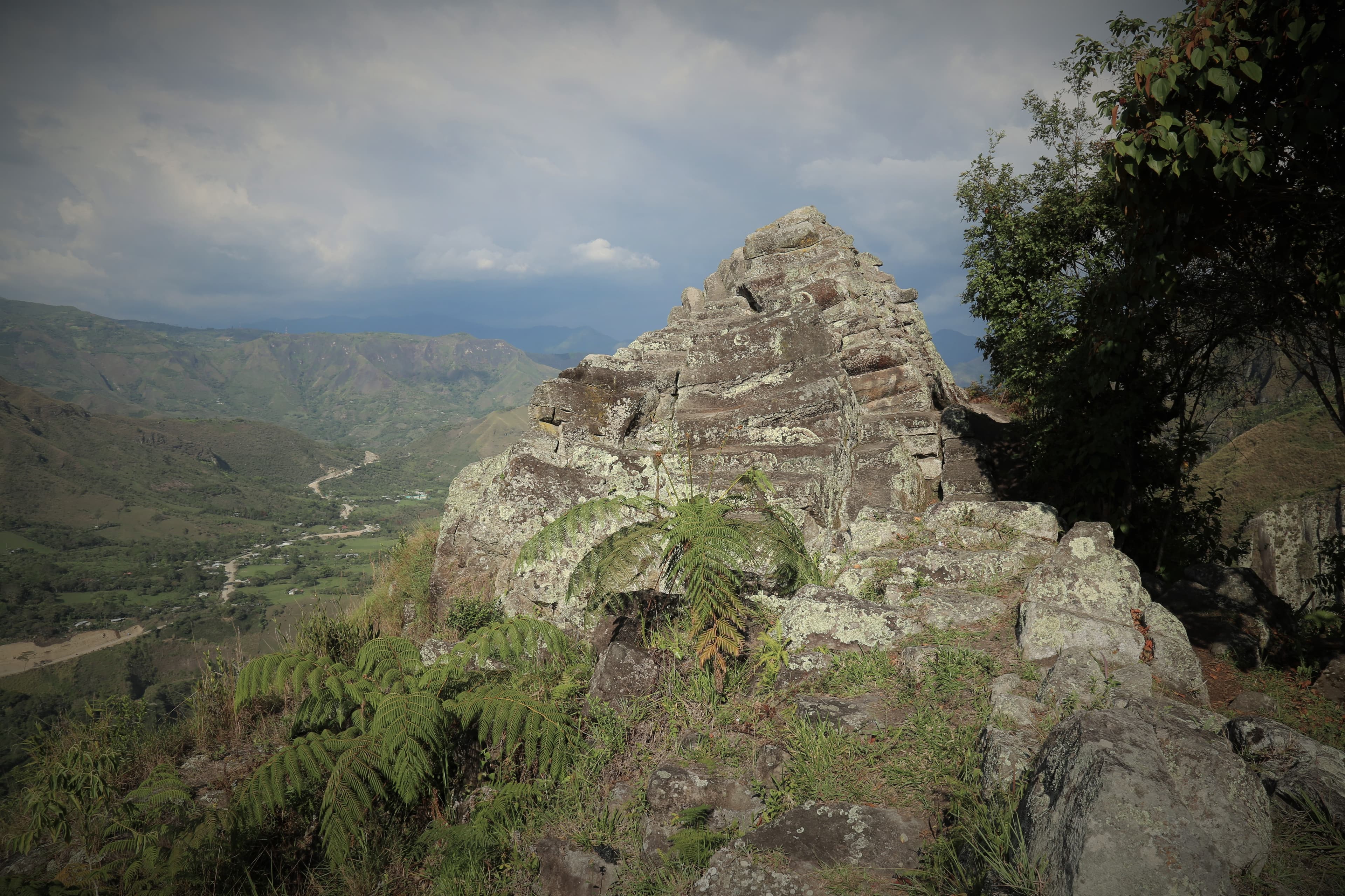
Near the town of Inza, a pyramidal stone formation rises from the Cauca mountainside, bearing the marks of two vastly different encounters. On its summit, pre-Columbian carvings of undetermined date and purpose confirm that the formation held significance for the same cultures that built the nearby Tierradentro hypogea. At its base, tunnels carved by Spanish colonial forces record a different kind of engagement: the search for gold believed to be hidden within the stone.
The pyramid is natural. The meanings assigned to it are not.
Rising from the volcanic landscape of the Cauca department near Inza, this pyramidal stone formation is a geological feature that humans have engaged with across centuries and across vastly different purposes. On its summit, carvings whose date and meaning remain undetermined confirm that the pre-Columbian inhabitants of the region recognized this formation as significant. The carvings may be territorial markers, ceremonial inscriptions, or astronomical observations. No one knows, because the people who made them left no text.
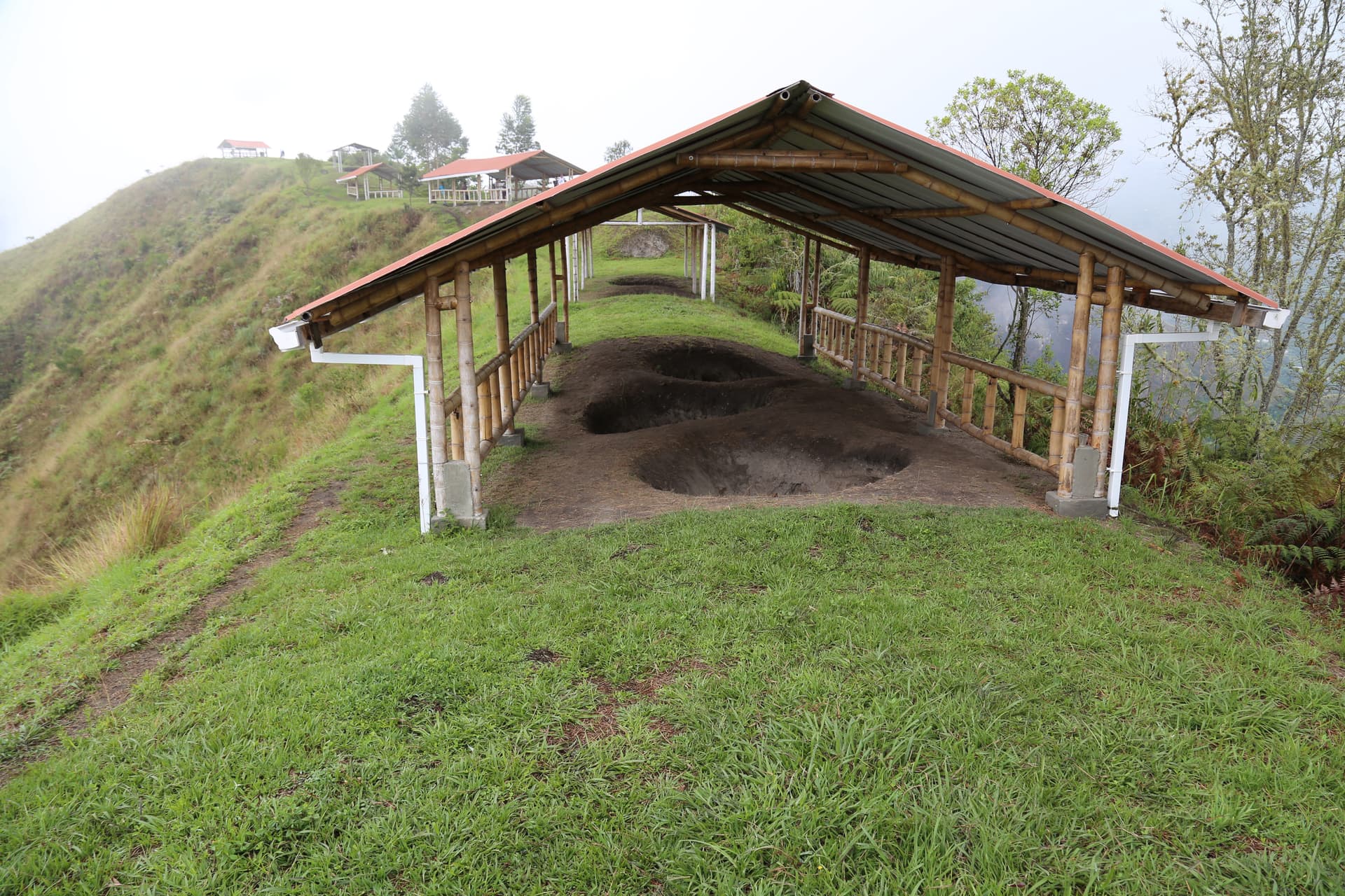
At the base, two tunnels penetrate the stone. These were carved not by the pre-Columbian inhabitants but by Spanish conquistadors, who arrived in the Tierradentro region with the conviction that indigenous peoples had hidden gold inside prominent natural features. Whether the tunnels were dug in search of treasure or for quarrying stone for colonial church construction is debated among local guides. Either way, the tunnels represent a starkly different relationship with the same formation: where the pre-Columbian carvings suggest reverence, the colonial tunnels suggest extraction.
The pyramid sits within Nasa indigenous territory, part of the broader Tierradentro landscape that includes the UNESCO-listed hypogea. Its proximity to the painted underground tombs places it within a sacred geography: in a landscape where the dead were housed in elaborately painted underground chambers, a towering stone pyramid rising from the earth would have carried powerful associations, a counterpoint to the subterranean world of the tombs.
The walk from Inza takes approximately thirty minutes uphill. The path passes through Nasa agricultural land, and the approach has a pilgrimage quality created by effort and elevation. At the summit, the carvings wait, their purpose as hidden as the gold the Spanish never found.
Part of Tierradentro Pyramid.
Context and lineage
The formation is geological in origin, a volcanic feature shaped by the same forces that created the tuff into which the Tierradentro hypogea were carved. The pre-Columbian carvings on its summit confirm human engagement, though their date, attributed tentatively to the same era as the nearby hypogea culture, remains unconfirmed by dedicated archaeological study. The Spanish colonial tunnels at the base represent a later engagement, driven by the search for gold or building stone.
The lineage at this site is one of layered engagement with the same natural feature: pre-Columbian inscription, colonial extraction, Nasa territorial continuity, and contemporary tourism. No continuous tradition of practice connects these layers; each represents a distinct relationship with the formation.
Pre-Columbian carvers
original makers of summit carvings
The unknown individuals who carved designs on the pyramid's summit, confirming its significance within the broader Tierradentro ceremonial landscape.
Spanish colonial forces
tunnel carvers
The colonial forces who carved tunnels at the base, either seeking gold or quarrying stone. Their work represents the extractive encounter between colonial power and indigenous sacred landscape.
Why this place is sacred
A natural pyramid in a landscape of underground tombs creates a vertical axis. The hypogea descend into the earth; the pyramid rises from it. If the builders of the tombs recognized this formation as significant, and the summit carvings suggest they did, then the pyramid may have served as a counterpoint to the underground world: the place where earth reaches toward sky, complementing the places where humans carved into its depths.
The Spanish tunnels at the base tell a parallel story of encounter but with opposite intent. The pre-Columbian people carved on the surface, marking the formation with designs that remained visible, exposed, part of the landscape's face. The Spanish carved into the formation, seeking to penetrate its interior, to extract what they believed was hidden within. The contrast between inscription and extraction, between honoring a surface and violating an interior, speaks to larger patterns in the colonial encounter.
The formation's natural pyramidal shape is itself noteworthy. Natural pyramids are rare and have attracted human attention in cultures worldwide. That this one sits within a landscape already dedicated to complex funerary architecture suggests it was not ignored by the hypogea builders. Its role within their cosmological system, however, remains a matter of speculation rather than evidence.
The pre-Columbian carvings on the summit suggest the formation held ceremonial, territorial, or observational significance. The specific purpose is undocumented.
The formation progressed from natural geological feature to pre-Columbian sacred site to colonial extraction target to modern tourist attraction. Each layer remains visible: the carvings on top, the tunnels below, and the formation itself beneath and around them all.
Traditions and practice
The pre-Columbian carvings indicate ritual or territorial engagement, though specific practices are unknown. The formation may have served as a lookout, a ceremonial landmark, or an observation point within the broader Tierradentro ceremonial landscape.
The site is visited by tourists exploring the Tierradentro region. Local guides in Inza offer accompaniment. A small entry fee supports site maintenance.
Walk slowly from Inza, letting the uphill effort create the attentiveness the site rewards. At the tunnels, enter and consider the labor of colonial extraction: the picks striking stone, the search for treasure that was not there. At the summit, look for the carvings and consider what they meant to the people who made them, people who also carved painted chambers deep underground in the surrounding mountains. The contrast between the underground tombs and this above-ground pyramid is not accidental in its effect: the same landscape that descends into the earth also rises from it.
Pre-Columbian Territorial and Ritual Use
HistoricalThe summit carvings confirm that the pre-Columbian inhabitants of the Tierradentro region recognized this natural formation as significant within their ceremonial landscape. The specific tradition and practices associated with the site are unknown.
Carving of designs on the pyramid's summit. Possible use as a landmark, observation point, or ceremonial site.
Nasa Territorial Stewardship
ActiveThe Nasa people are the current inhabitants of the territory. The pyramid sits within their homeland, and their ongoing presence maintains the connection between the landscape and its living community.
Territorial governance, agricultural use of surrounding land, maintenance of the site as part of the broader Tierradentro landscape.
Experience and perspectives
The walk from Inza is itself part of the experience. The path climbs through Nasa agricultural land, the terraced fields and modest houses providing a context of living indigenous presence. The effort of the uphill walk, moderate but sustained, strips away the casual and creates the attentiveness that the site rewards.
The pyramid comes into view before you reach it, its shape distinct against the mountain backdrop. The scale is impressive but not overwhelming. This is not an Egyptian pyramid or a Mesoamerican temple platform. It is a natural stone formation, and its power lies in the combination of geological chance and human recognition: nature produced this shape, and humans across centuries have responded to it.
The tunnels at the base are accessible and worth entering. They are dark, narrow, and cool, and standing inside them, considering the labor of carving into solid rock with colonial tools, gives a physical sense of the effort the Spanish invested in their conviction that treasure lay within. The tunnels found no gold.
The summit carvings require more patience to appreciate. They are weathered and subtle, their designs worn by centuries of exposure. A local guide can help identify and interpret them, though interpretation remains tentative. What is clear is that human hands shaped these designs on the highest point of the formation, claiming the summit as a place of significance.
The views from the approach path encompass the Tierradentro valley, placing the pyramid within the broader landscape that includes the hypogea sites. In clear weather, the relationship between the above-ground pyramid and the underground tombs becomes visible as a geographical fact: the same landscape that holds the dead below the surface also pushes this stone formation toward the sky.
No formal guided tours operate at the pyramid, but local guides in Inza can accompany visitors. The walk from Inza takes approximately thirty minutes uphill. Visit the tunnels at the base first, then ascend to view the summit carvings. Bring a flashlight for the tunnels. Best combined with a multi-day visit to the main Tierradentro Archaeological Park.
The Tierradentro Pyramid is a modest site with a layered story. The pre-Columbian carvings, the colonial tunnels, and the Nasa territorial context create a small-scale study in how different cultures engage the same landscape.
The pyramid receives minimal attention in academic literature compared to the nearby hypogea. It is acknowledged as a natural geological formation with pre-Columbian carvings and colonial-era tunnels. No dedicated archaeological study has been published in widely available sources. The carvings' relationship to the hypogea culture is assumed but unconfirmed.
The Nasa recognize the pyramid as part of their ancestral territorial landscape. Specific oral traditions related to the formation may exist within the community but are not documented in available sources.
Some visitors and alternative history enthusiasts have speculated about the formation being partially human-made or having astronomical alignments. These claims are not supported by archaeological evidence.
The exact date and cultural context of the summit carvings remain unknown. Whether the pyramid served a specific function within the broader Tierradentro ceremonial landscape is undetermined. The precise purpose of the Spanish colonial tunnels, gold seeking or quarrying, is debated. Whether the formation was modified or enhanced by pre-Columbian peoples beyond the summit carvings is unknown.
Visit planning
Located approximately thirty minutes' walk uphill from the town of Inza, Cauca Department, Colombia. Inza is accessible by bus from Popayan, approximately four hours. No public transport directly to the pyramid. Entry fee approximately 5,000 COP. No facilities at the site. Mobile phone signal may be limited on the approach and at the site; confirm availability before relying on it.
Basic accommodation is available in Inza. More options exist in San Andres de Pisimbala, near the main archaeological park. Popayan, approximately four to five hours away, offers the fullest range of accommodation.
The Tierradentro Pyramid is a natural formation with archaeological features in Nasa indigenous territory. Respect the carvings, exercise caution in the tunnels, and treat the surrounding territory with the respect due to an indigenous homeland.
Sturdy walking shoes for the uphill approach and potentially uneven tunnel floors.
Photography is permitted without restriction.
Do not leave offerings or graffiti on the formation.
Do not add to or deface existing carvings. Exercise caution inside the tunnels. Do not remove stones or objects from the site.
Plan your visit
Address
Inza, Cauca, Colombia
Hours
Hours, fees, and access can change — verify on the official source before you travel. Practical details last checked Jun 2026.
Nearby sacred places
Sacred places within a half-day’s reach. Pilgrims often visit them together: walk one, stay for the other.


Key questions
What pilgrims usually ask
- Why is Tierradentro Pyramid considered sacred?
- Hike to the Tierradentro Pyramid near Inza, Colombia, a natural formation with pre-Columbian summit carvings and Spanish colonial tunnels.
- What should I wear at Tierradentro Pyramid?
- Sturdy walking shoes for the uphill approach and potentially uneven tunnel floors.
- Can I take photos at Tierradentro Pyramid?
- Photography is permitted without restriction.
- How long should I spend at Tierradentro Pyramid?
- One to two hours including the walk from Inza and time to explore the tunnels and summit.
- How do you visit Tierradentro Pyramid?
- Located approximately thirty minutes' walk uphill from the town of Inza, Cauca Department, Colombia. Inza is accessible by bus from Popayan, approximately four hours. No public transport directly to the pyramid. Entry fee approximately 5,000 COP. No facilities at the site. Mobile phone signal may be limited on the approach and at the site; confirm availability before relying on it.
- What offerings are appropriate at Tierradentro Pyramid?
- Do not leave offerings or graffiti on the formation.
- What etiquette should visitors follow at Tierradentro Pyramid?
- The Tierradentro Pyramid is a natural formation with archaeological features in Nasa indigenous territory. Respect the carvings, exercise caution in the tunnels, and treat the surrounding territory with the respect due to an indigenous homeland.
- What is the history of Tierradentro Pyramid?
- The formation is geological in origin, a volcanic feature shaped by the same forces that created the tuff into which the Tierradentro hypogea were carved. The pre-Columbian carvings on its summit confirm human engagement, though their date, attributed tentatively to the same era as the nearby hypogea culture, remains unconfirmed by dedicated archaeological study. The Spanish colonial tunnels at the base represent a later engagement, driven by the search for gold or building stone.