Theimussa
Lycian sarcophagi stand among fishing boats in a living village where the ancient dead never quite left
Turkey
Plan this visit
Practical context before you go
2–3 hours for the village ruins and quay walk; half day to full day including a Kekova boat tour.
Üçağız is located 20 km from Kaş and 33 km from Demre (Myra), Antalya Province. The road from the D400 coastal highway is approximately 19 km and takes about 30 minutes. Most popular access is by boat tours from Kaş or Demre — these typically include Üçağız as a stop, passing the Kekova sunken ruins en route. The bay is a standard stop on gulet cruise routes along the Lycian coast. Mobile phone signal may be unreliable in the valley approaching Üçağız; signal generally available in the village itself. For emergency access, the nearest hospital is in Kaş (20 km) or Demre (33 km). No formal entrance fee for the village ruins; boat tour fees vary by operator.
Üçağız is both a living village and an archaeological site. The combination asks for the courtesy appropriate to both.
At a glance
- Coordinates
- 36.1973, 29.8504
- Type
- Ancient Settlement
- Suggested duration
- 2–3 hours for the village ruins and quay walk; half day to full day including a Kekova boat tour.
- Access
- Üçağız is located 20 km from Kaş and 33 km from Demre (Myra), Antalya Province. The road from the D400 coastal highway is approximately 19 km and takes about 30 minutes. Most popular access is by boat tours from Kaş or Demre — these typically include Üçağız as a stop, passing the Kekova sunken ruins en route. The bay is a standard stop on gulet cruise routes along the Lycian coast. Mobile phone signal may be unreliable in the valley approaching Üçağız; signal generally available in the village itself. For emergency access, the nearest hospital is in Kaş (20 km) or Demre (33 km). No formal entrance fee for the village ruins; boat tour fees vary by operator.
Pilgrim tips
- Respectful dress in the village is appropriate; swimwear is acceptable on boats and near the water.
- Photography is permitted throughout the site and village. Residents may prefer not to be photographed without permission.
- The village is small and the ruins are accessible but unfenced. The sarcophagi are archaeological monuments and not to be touched or climbed. Swimming near the submerged ruins of Kekova Island is not permitted in the protected area. Boat access to Kekova is regulated — the official tour boats from Kaş and Demre are the simplest access.
Overview
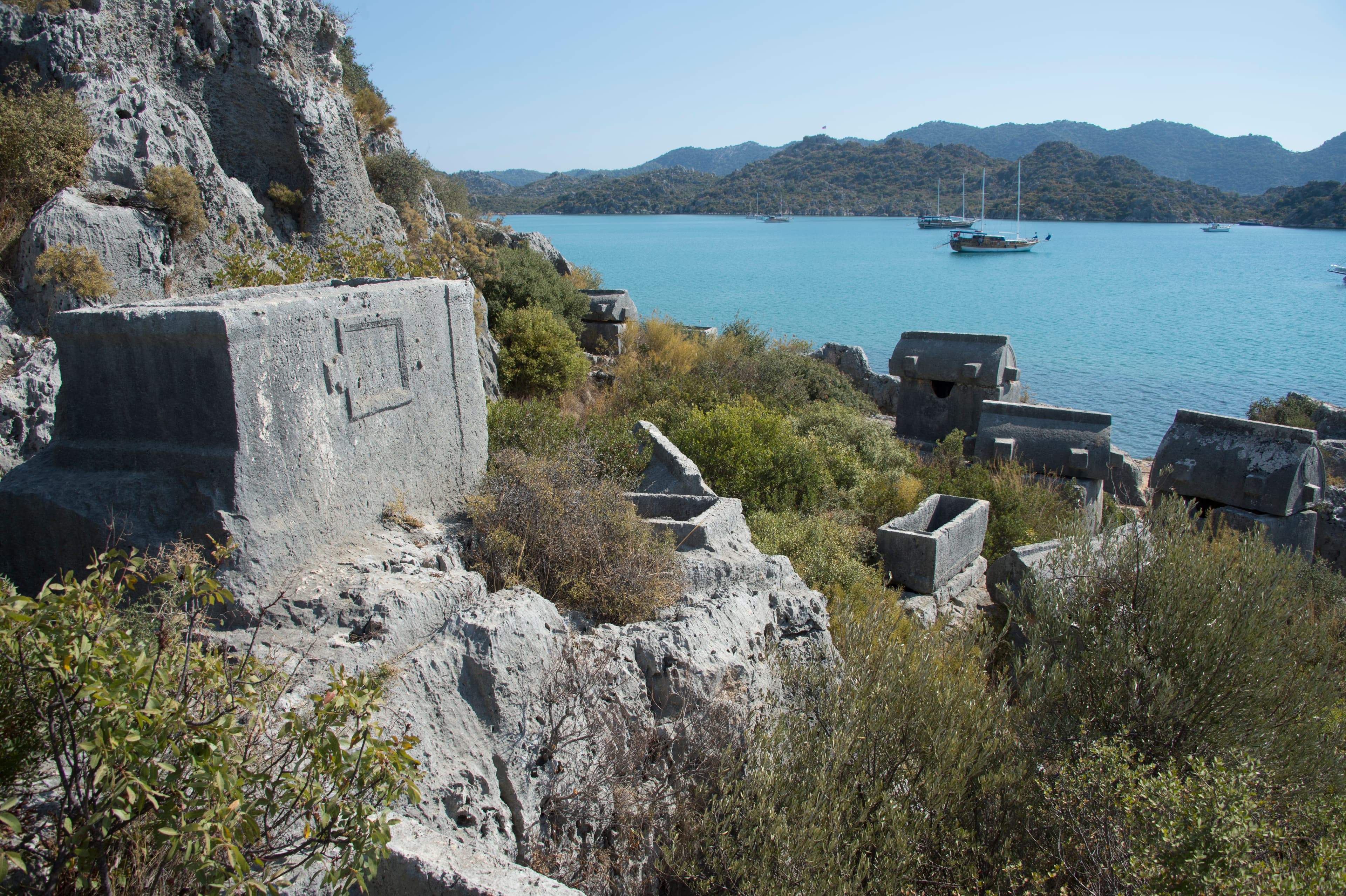
At Üçağız, the ancient village of Theimussa, the line between archaeology and daily life has never fully closed. Lycian sarcophagi from the 4th century BCE rise from rocky hillsides above a sheltered bay, separated from fishing boats and village cats by a few meters of path. Part of the city wall runs into the sea and continues underwater. A rock-cut quay still shows the chisel marks of its builders. This is one of Turkey's most intimate encounters with the ancient Lycian world.
Most ancient sites are cleanly separated from the present. Theimussa is not. The village of Üçağız sits within and around the ruins of the ancient Lycian harbor town, and the centuries have not produced a clean line between them. A house-shaped Lycian sarcophagus from the 4th century BCE stands in the middle of a path that villagers walk daily. The city wall, where it meets the harbor, descends into the water and continues submerged — claimed by the sea in some seismic event whose date is unknown, its upper stones still visible at the tideline.
Theimussa was a small city by ancient standards, a harbor community and member of the Lycian League, its civic identity expressed not through great temples or monumental civic buildings but through its tombs. The inscriptions on those tombs record something quietly remarkable: many of the people buried here were not citizens of Theimussa itself. They were citizens of Cyaneae and Myra — larger cities inland and to the east — who chose this sheltered bay for their burial. Theimussa was a place that the dead of neighboring communities selected deliberately.
The bay of Üçağız is shaped like a bowl. Kekova Island closes the southern horizon; green hills rise on three sides. The water is still, the light afternoon-golden on the limestone. Gulet sailboats anchor offshore. The sarcophagi on the hillside look down at all of it, as they have for twenty-five centuries.
Context and lineage
No founding mythology survives for Theimussa. The settlement enters the historical record through its material remains — tombs, inscriptions, walls, and the rock-cut quay — rather than through myth or textual narrative. What the inscriptions reveal is that the city was deeply embedded in the network of Lycian communities along the coast: its dead came from elsewhere, choosing this bay for their permanent rest. The ancient name Theimussa or Teimiussa may encode a local geographic feature; its meaning is not fully established.
The settlement's participation in the Lycian League connects it to one of the ancient world's most sophisticated experiments in federal governance — a system of proportional representation across twenty-three cities that the Founding Fathers of the United States later cited as a historical precedent. That such a system included a small harbor settlement like Theimussa alongside great cities like Xanthos and Myra reflects the League's genuinely inclusive character.
Theimussa sits within the broader Lycian cultural tradition, sharing the characteristic funerary theology — sky-elevated sarcophagi, inscriptions protecting the dead — with the great Lycian sites to the north. Its small scale and harbor character distinguish it from the more monumental capitals; its preservation within a living village is the outcome of continuous low-intensity settlement rather than formal conservation.
Why this place is sacred
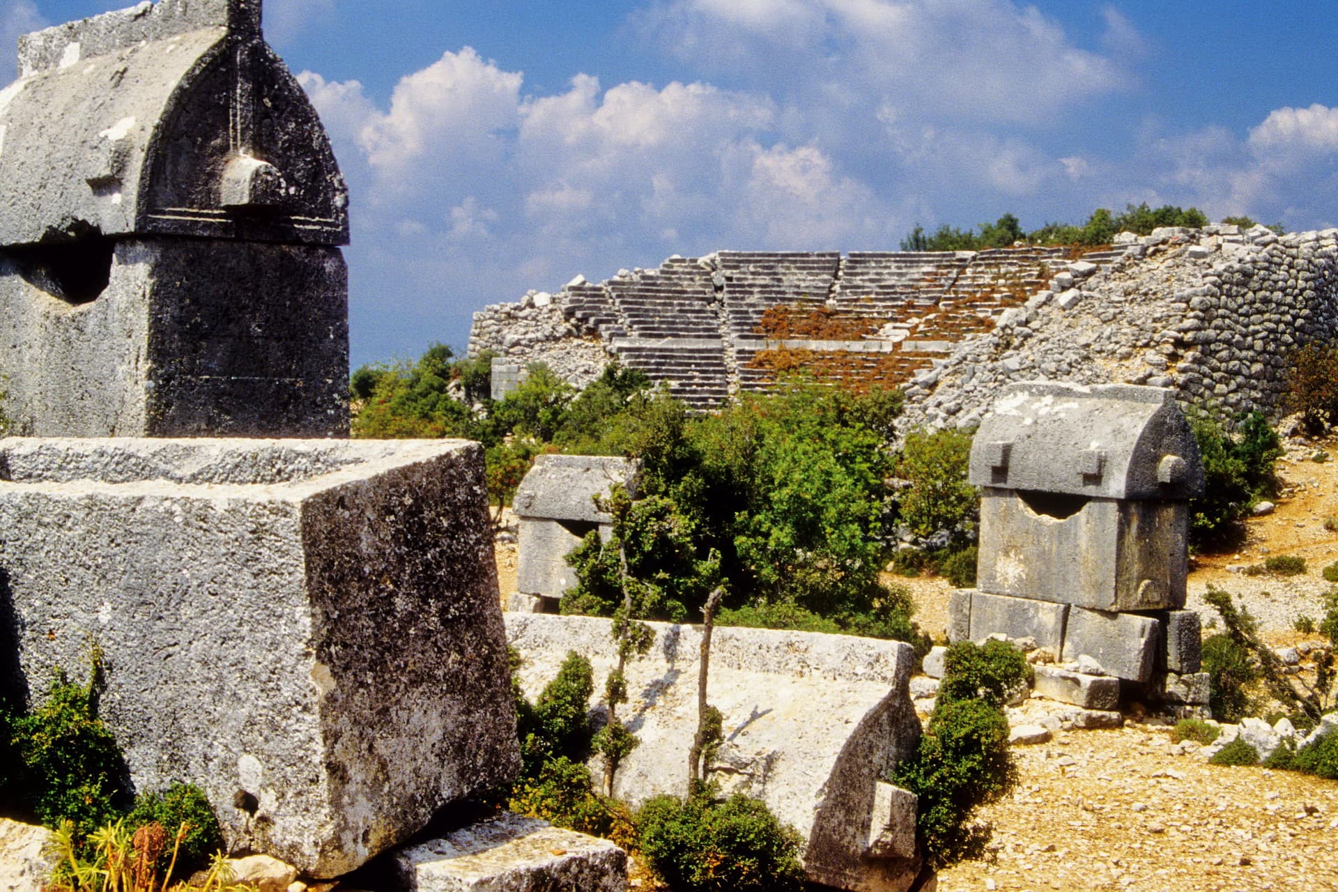
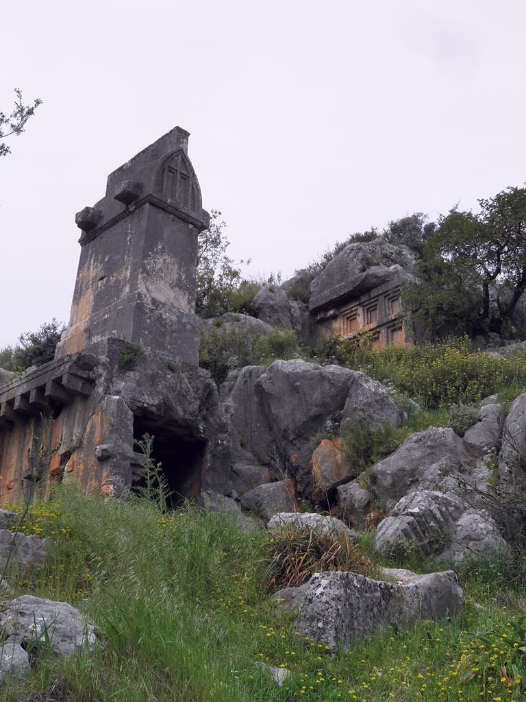
Lycian funerary theology ran through the same logic here as at Xanthos or Kaunos: the honored dead belonged in elevation, above the ground, facing the open sky and the sea. At Theimussa the sarcophagi are placed on rocky hillside outcrops above the harbor, their house-shaped lids and carved facades oriented outward, toward the water and the island and the horizon beyond.
The Lycian sarcophagus — stone box on a high base, lid shaped like a pitched roof, sometimes decorated with relief carvings — was a private theology of permanence. The base lifted the occupant above the ground. The lid pointed upward. The placement on an elevated rock face above a bay combined all three axes of Lycian sacred geography: height (sky-direction), proximity to water (the sea as threshold), and visibility from the community below.
Theimussa adds a fourth dimension that other sites lack: submersion. Part of the ancient city wall now lies underwater, visible from a boat, its stones continuing beneath the surface into the silted harbor floor. Whether this resulted from gradual coastal change or a more sudden seismic event is not settled. But the effect is profound — here the ancient world literally continues beneath the present one, the boundary between land and sea as permeable as the boundary between life and death that the sarcophagi above mark.
The fact that citizens of Cyaneae and Myra chose Theimussa for their burial suggests the bay held some quality — perhaps its stillness, perhaps its protected character, perhaps its specific relationship to the sea route along the Lycian coast — that made it an appropriate threshold place for the permanent resting of the dead.
Harbor settlement and Lycian League member; functioned as a regional burial ground for citizens of neighboring cities including Cyaneae and Myra.
Theimussa was settled from at least the 4th century BCE. It continued through Hellenistic and Roman periods. The modern village of Üçağız grew within and around the ancient ruins without displacing them — an unusual continuity of settlement on the same ground. Today the site is within the Kekova Special Environmental Protection Area.
Traditions and practice
Lycian funerary rites at Theimussa involved the preparation of the sarcophagus chamber, formal burial with inscriptions naming the deceased and their civic affiliation, and probably ongoing commemorative observances by family members or civic representatives. Maritime rites at the harbor — offerings or prayers at the quay before and after sea journeys — may have occurred, as was common in ancient harbor communities, though no specific evidence survives at this site.
No active religious ceremonies take place at Theimussa. The village of Üçağız operates as a small fishing and tourism community. The Kekova boat tour circuit, which typically includes Üçağız as a stop, brings regular visitors to the ruins. Sea kayaking through the bay and along the Kekova coast has become a popular way to approach the site from the water.
Walk the eastern end of the harbor to the rock-cut quay first. Put your hand on the vertical chisel-marked wall. This is not a carved monument — it is a working surface, the wall of a loading dock where goods and people moved between boats and land. Then walk back through the village, pausing at each sarcophagus. Read the inscriptions if you can — even without ancient Greek or Lycian, you can see that these are not mere decorations but legal documents carved in stone, the names and protections of specific people who wanted to be remembered.
Then climb the hillside above the village far enough to see the whole bay at once: the sarcophagi below you, the water, Kekova Island on the southern horizon, and the boat or two anchored in the still morning. The Lycians who placed their dead here were orienting them toward exactly this view.
If you have a boat tour of Kekova planned, do the village walk first. The submerged ruins of the ancient Kekova shore — walls and building foundations visible just beneath the surface — complete the picture that Theimussa begins: a civilization whose relationship with the sea was not a boundary but a continuation.
Lycian Funerary Religion
HistoricalTheimussa's necropolis expresses Lycian funerary theology at an intimate scale: sarcophagi on rocky hillsides above a sheltered bay, their house-shaped lids oriented skyward, their inscriptions naming the dead and protecting the chambers. The unusual presence of burial inscriptions for citizens of Cyaneae and Myra suggests Theimussa's bay was selected as a threshold place by those cities' elite.
Sarcophagus burial on elevated rocky outcrops; inscriptions naming the deceased and their civic affiliation; legal formulae protecting the tomb from violation; maritime funerary orientation
Lycian League / Maritime Community
HistoricalAs a member of the Lycian League, Theimussa participated in the pan-Lycian civic and religious life that connected the small harbor settlement to great cities like Xanthos, Patara, and Myra. Its maritime character — rock-cut quay, protected harbor, Kekova Island shelter — made it a node in the coastal network of Lycian trade and culture.
Maritime trade; harbor operations; participation in Lycian League governance; connections to Cyaneae and Myra
Archaeological / Heritage
ActiveTheimussa is part of the Kekova Special Environmental Protection Area, one of Turkey's most intact ancient maritime landscapes. The integrated ruins and living village create one of the most authentic archaeological environments on the Lycian coast.
Heritage tourism; gulet cruise stops; sea kayaking; village life continuing alongside the ruins
Experience and perspectives
The road into Üçağız descends from the main coastal highway through 19 kilometers of winding mountain road, dropping finally to the bay. The village at the end of this road has a quality of arrival that the drive earns — a contained, sheltered world that feels genuinely apart from the tourist infrastructure of the Lycian coast.
Walking the village path, you encounter the sarcophagi without announcement. They stand beside houses, behind walls, on rocky outcrops above the waterline. Some are inscribed; some have lost their lids; some remain largely intact. The oldest — house-shaped, from the 4th century BCE — have been weathered by twenty-five centuries of Lycian winter rain and summer heat. The stone is warm to the ambient temperature. Nothing is roped off.
At the eastern end of the harbor, a rock-cut quay measures 9 meters long and 9 meters wide, its vertical walls still showing the chisel marks of its builders. Stand on this quay and look at the chisel marks — the direct physical evidence of someone working this stone in the 4th century BCE or later. The quay's edge is a few centimeters above the water. A boat tied here would have been at arm's reach from the steps. The integration of ancient maritime infrastructure into the living village is total.
From any point in the village, the enclosing bay and Kekova Island frame the view. In early morning, before the gulet tours arrive from Kaş, the water is still enough to reflect the hills. The sarcophagi on the slopes above are the first things the morning light catches. The sensation is less of visiting a site than of arriving in a place that has always been this way.
Come by road rather than by boat if possible, at least once — the arrival experience down the mountain road is part of what Üçağız is. Boat tours from Kaş and Demre are efficient but arrive at the dock without the descent. Allow a minimum of two hours for the village ruins; a half day or full day when combined with a Kekova boat tour.
Theimussa is a site that speaks through its particulars rather than its monuments. The Lycian theology it expresses is the same theology visible at Xanthos or Patara — but here it is intimate, embedded in a living village, felt at the scale of a single sarcophagus on a hillside path rather than a hilltop city.
Theimussa was a small but significant Lycian harbor community from at least the 4th century BCE. Its tomb inscriptions recording citizens of Cyaneae and Myra suggest it functioned as a regional burial ground serving multiple communities — an unusual characteristic that points to the bay's special quality as a threshold place. The rock-cut quay is a well-preserved example of Lycian maritime infrastructure. The site forms part of the broader Kekova archaeological landscape, one of the most intact ancient maritime zones on the Turkish coast.
Within Lycian tradition, tombs placed above the sea and bay connected the dead to the maritime world — entirely appropriate for a sailor community at a protected harbor. The Lycian sky-oriented burial theology expressed through the hillside sarcophagi positioned the dead to face outward, toward the sea-horizon, in a direction that had theological as well as geographic significance. The submerged wall raises the possibility, within Lycian cosmological thinking, that the sea itself claimed a portion of the city — a reading the ancient inhabitants might have found entirely comprehensible.
The partial submersion of the city wall has inspired speculation about a sudden seismic event that sank portions of Theimussa into the sea — an Aegean equivalent of the 'lost city' mythology. The slow coastal subsidence that geologists consider more likely is less dramatic but no less transformative over centuries. The effect, as seen from a boat today, is the same either way: a civilization that continues beneath the surface.
The full extent of the submerged portions of Theimussa has not been mapped. The relationship between Theimussa's burial population (many from Cyaneae and Myra) and its living population is not fully understood — was the city primarily a burial ground that happened to be inhabited, or a harbor settlement that happened to attract outside burials? The specific character of its participation in Lycian League governance — how many votes its population entitled it to, what offices its citizens held — is not documented.
Visit planning
Üçağız is located 20 km from Kaş and 33 km from Demre (Myra), Antalya Province. The road from the D400 coastal highway is approximately 19 km and takes about 30 minutes. Most popular access is by boat tours from Kaş or Demre — these typically include Üçağız as a stop, passing the Kekova sunken ruins en route. The bay is a standard stop on gulet cruise routes along the Lycian coast. Mobile phone signal may be unreliable in the valley approaching Üçağız; signal generally available in the village itself. For emergency access, the nearest hospital is in Kaş (20 km) or Demre (33 km). No formal entrance fee for the village ruins; boat tour fees vary by operator.
Several small pensions and guesthouses operate in Üçağız village; simple, unpretentious, and close to the ruins. Kaş (20 km) offers a wider range. The bay is a standard overnight anchorage for gulet cruises; boats anchored in the harbor create a unique accommodation arrangement with the sarcophagi in view from the deck.
Üçağız is both a living village and an archaeological site. The combination asks for the courtesy appropriate to both.
Respectful dress in the village is appropriate; swimwear is acceptable on boats and near the water.
Photography is permitted throughout the site and village. Residents may prefer not to be photographed without permission.
Not applicable.
Do not touch or climb the sarcophagi. Swimming near the submerged ruins of Kekova Island is prohibited in the Special Environmental Protection Area. Respect village property and residential boundaries where ruins abut inhabited spaces.
Nearby sacred places
Sacred places within a half-day’s reach. Pilgrims often visit them together: walk one, stay for the other.


References
Sources consulted when researching this page. Independent verification by readers is welcome.
- 01An Ancient Tomb Relief at Teimiussa, modern Üçağız in Lycia, Turkey — Peter Sommer Travelshigh-reliability
- 02Teimussa Ancient City | ArticHaeology — ArticHaeology
- 03Kale - Üçağız (Teimiussa), Turkey — Turkey Travel Planner
- 04Teimiussa [Üçagiz, Simena] Ancient Village or Settlement — Megalithic.co.uk
- 05Theimussa Ancient City Antalya — Her Antalya
- 06The ancient city of Üçağız and Theimussa — Visit My Turkey
- 07Ucagiz Travel Guide, Antalya, Turkey — Boat Trip Turkey
- 08Theimussa (Üçağız) Village - Antalya - Kekova Tour — Kekova Tour
Key questions
What pilgrims usually ask
- Why is Theimussa considered sacred?
- Ancient Lycian tombs stand among fishing boats in Üçağız village. Theimussa's 4th-century BCE sarcophagi overlook a sheltered bay where the city wall meets the
- What should I wear at Theimussa?
- Respectful dress in the village is appropriate; swimwear is acceptable on boats and near the water.
- Can I take photos at Theimussa?
- Photography is permitted throughout the site and village. Residents may prefer not to be photographed without permission.
- How long should I spend at Theimussa?
- 2–3 hours for the village ruins and quay walk; half day to full day including a Kekova boat tour.
- How do you visit Theimussa?
- Üçağız is located 20 km from Kaş and 33 km from Demre (Myra), Antalya Province. The road from the D400 coastal highway is approximately 19 km and takes about 30 minutes. Most popular access is by boat tours from Kaş or Demre — these typically include Üçağız as a stop, passing the Kekova sunken ruins en route. The bay is a standard stop on gulet cruise routes along the Lycian coast. Mobile phone signal may be unreliable in the valley approaching Üçağız; signal generally available in the village itself. For emergency access, the nearest hospital is in Kaş (20 km) or Demre (33 km). No formal entrance fee for the village ruins; boat tour fees vary by operator.
- What offerings are appropriate at Theimussa?
- Not applicable.
- What etiquette should visitors follow at Theimussa?
- Üçağız is both a living village and an archaeological site. The combination asks for the courtesy appropriate to both.
- What is the history of Theimussa?
- No founding mythology survives for Theimussa. The settlement enters the historical record through its material remains — tombs, inscriptions, walls, and the rock-cut quay — rather than through myth or textual narrative. What the inscriptions reveal is that the city was deeply embedded in the network of Lycian communities along the coast: its dead came from elsewhere, choosing this bay for their permanent rest. The ancient name Theimussa or Teimiussa may encode a local geographic feature; its meaning is not fully established. The settlement's participation in the Lycian League connects it to one of the ancient world's most sophisticated experiments in federal governance — a system of proportional representation across twenty-three cities that the Founding Fathers of the United States later cited as a historical precedent. That such a system included a small harbor settlement like Theimussa alongside great cities like Xanthos and Myra reflects the League's genuinely inclusive character.