Sleeping Bear Dunes, Michigan
Where a mother bear still watches the waters for her lost cubs, now islands in Lake Michigan
Empire, Michigan, United States

Plan this visit
Practical context before you go
A half day allows visiting the main overlooks and Dune Climb. A full day permits exploration of multiple areas plus beach time. Multiple days allow for island visits, hiking, and more contemplative engagement. A week could easily be spent exploring the full lakeshore.
Visitors to Sleeping Bear Dunes should respect both the natural environment and its Indigenous sacred significance. Follow park regulations, practice Leave No Trace, and approach the landscape with awareness of the story it embodies. Do not create your own rituals or appropriate Indigenous practices.
At a glance
- Coordinates
- 44.8747, -85.9869
- Suggested duration
- A half day allows visiting the main overlooks and Dune Climb. A full day permits exploration of multiple areas plus beach time. Multiple days allow for island visits, hiking, and more contemplative engagement. A week could easily be spent exploring the full lakeshore.
Pilgrim tips
- Appropriate outdoor clothing for Great Lakes shoreline conditions. Sun protection in summer. Good shoes for dune climbing, which involves strenuous walking on loose sand. Swimwear for beach areas. The weather can change quickly; bring layers.
- Photography is permitted throughout the park. Use respectfully. The landscape is both natural feature and sacred geography. Let your photographs reflect both dimensions.
- The popular version of the Sleeping Bear legend, while accurate as far as it goes, lacks the deeper spiritual meanings characteristic of Anishinaabe sacred narratives. Members of the Grand Traverse Band have expressed concerns about how the story has been simplified for tourist consumption. Visitors should understand that what they receive is introduction, not initiation. The full teaching belongs to those who have earned it through cultural membership and traditional learning. Respect this boundary. Do not appropriate Indigenous practices or claim understanding you do not possess. Appreciation and appropriation are different things.
Overview
Along the northwestern shore of Michigan's Lower Peninsula, towering dunes rise 450 feet above Lake Michigan, and two islands hover on the horizon. The Ojibwe tell of a mother bear who fled a Wisconsin forest fire with her cubs, swimming toward the Michigan shore. The cubs drowned within sight of land. The Great Spirit, moved by the mother's faithful watching, raised North and South Manitou Islands to mark where they fell. The mother was buried under the sands, where she waits still. This is sacred geography: land and water transformed into story of love, loss, and divine compassion.
The Sleeping Bear Dunes National Lakeshore preserves 71,000 acres of some of the most dramatic landscape in the Great Lakes region: towering perched dunes, miles of Lake Michigan shoreline, forests, and the two Manitou Islands that rise from the lake's blue waters. For most visitors, this is scenery. For the Anishinaabe, the Ojibwe and Odawa and Potawatomi peoples who have inhabited this region for millennia, it is something more: sacred geography, a landscape that teaches spiritual truths.
The legend of the sleeping bear is not folklore in the dismissive sense but sacred narrative. A mother bear and her two cubs fled a forest fire in Wisconsin, plunging into Lake Michigan and swimming toward the distant Michigan shore. The mother reached land and climbed the high bluff to watch for her children. But the cubs, exhausted by the long swim, drowned within sight of safety.
The mother waited. She watched the waters. She would not leave the spot where she had last seen her children. Gitche Manitou, the Great Spirit, was moved by her faithfulness. He raised two islands from the lake, North and South Manitou, to mark where the cubs had perished and to honor their bravery. The winds buried the sleeping mother under sand, where she waits still for children who will never come.
The name Manitou carries weight. In Algonquian understanding, manitou is the spiritual power that pervades all things, the sacred essence present in every part of creation. To name these islands Manitou is to identify them as places where that power is particularly present, where the veil between ordinary and sacred grows thin.
The landscape confirms what the story teaches. Standing on the high dunes, looking out at the islands floating on the horizon, you can see the story. The mother waits on the bluff. The children rest in the waters. The Great Spirit's compassion is written in geography itself. This is not metaphor but map.
For over ten thousand years, Indigenous peoples have inhabited this region. The legend as we know it was first documented in 1891, but the relationship to this land extends far deeper. Members of the Grand Traverse Band, while acknowledging the story, have expressed concerns about how it has been popularized, stripped of the deeper spiritual meanings that characterize Anishinaabe sacred narratives. The story as tourists know it is true as far as it goes. But it does not go as far as traditional understanding reaches.
Context and lineage
The legend exists in multiple versions, all sharing the same basic narrative. A mother bear and her two cubs fled a forest fire in Wisconsin. They plunged into Lake Michigan and swam toward the distant Michigan shore. The mother reached land and climbed a high bluff to watch for her children. But the cubs, exhausted by the long swim, drowned within sight of safety.
The mother waited. She watched. She would not leave. Gitche Manitou, the Great Spirit, was moved by her devotion. He raised two islands from the waters where the cubs had drowned, honoring their bravery. North Manitou and South Manitou stand as their memorial. The winds buried the sleeping mother under sand, where she waits still.
The story teaches multiple lessons. Love persists. Faithfulness is seen. The divine responds to devotion. Loss can be honored without being erased. The landscape embodies these teachings, making them visible to all who learn to see.
The Sleeping Bear legend belongs to the Anishinaabe peoples: the Ojibwe, Odawa, and Potawatomi who form the Council of Three Fires. These peoples have inhabited the Great Lakes region for millennia, developing relationships with the land that are expressed in stories like this one.
The legend participates in broader Anishinaabe traditions of sacred geography, in which landscape features are understood as embodiments of spiritual truth rather than mere natural phenomena. The mountains, lakes, and rivers of the Great Lakes region are not just resources but teachers.
Michigan is home to twelve federally recognized tribes who maintain cultural connections to the Great Lakes landscape. The Grand Traverse Band is particularly associated with the Sleeping Bear region. Their relationship to this story is ongoing, including critical engagement with how the legend has been popularized.
The Mother Bear
Central figure of the legend
The Cubs
Central figures of the legend
Gitche Manitou
The Great Spirit
Henry Rowe Schoolcraft
Collector of Ojibwe legends
Why this place is sacred
Climb the steep dune and stand at the overlook. Below, Lake Michigan stretches to the horizon, blue water meeting blue sky. On that horizon, two islands float: North Manitou and South Manitou, the islands raised by the Great Spirit to honor the drowned cubs.
Look down at the dune beneath your feet. Somewhere under this sand, according to the legend, the mother bear sleeps, still waiting for children who will never come. The dune is her burial mound, shaped by winds that buried her where she watched. The high bluff she climbed to see her cubs is now a tourist overlook, but its original purpose was a mother's vigil.
This is sacred geography. The story is not separate from the landscape but written in it. The dunes, the islands, the lake that separates them: all are characters in a narrative of love, loss, and divine response. To know the story is to see the landscape differently. What was scenery becomes scripture.
The name Manitou signals this sacred dimension. In Anishinaabe understanding, manitou is the spiritual power present in all things, the sacred essence that pervades creation. To name islands Manitou is to identify them as places where that presence is particularly strong, where the ordinary and the sacred intersect. These are not merely islands but spiritual locations.
Gitche Manitou, the Great Spirit, responds to the mother's faithfulness with compassion. The story teaches that devotion is seen, that love persists beyond death, that the divine pays attention to faithful waiting. The mother's vigil was not wasted. The Great Spirit noticed. The islands are proof.
For contemporary visitors, the story offers entry into a way of seeing that consumer culture does not encourage. The landscape is not resource to be exploited but text to be read, relationship to be honored. The Anishinaabe have read this text for millennia. Visitors who learn the story can begin to read it too.
Members of the Grand Traverse Band have noted that the popular version of the story, while not inaccurate, lacks the deeper spiritual meanings characteristic of Anishinaabe sacred narratives. What tourists receive is introduction, not initiation. The full teaching belongs to those who have earned it through cultural membership and traditional learning.
The landscape predates human interpretation. The dunes formed through glacial and aeolian processes over thousands of years. The islands are remnants of the same geological processes. What the Anishinaabe added was meaning: the recognition that this particular landscape configuration embodied spiritual truths worth preserving in story.
The legend served to teach. It taught about love, about loss, about divine compassion. It taught that the landscape was not random but meaningful, not accident but intention. It taught the proper relationship between humans and the land they inhabited: reverence, attention, humility before powers greater than human.
The legend was first documented in English in the Detroit Free Press on January 23, 1891. Earlier documentation may exist in the work of Henry Rowe Schoolcraft, who collected Ojibwe legends in the early nineteenth century with the help of his wife Jane Johnston, who was of Ojibwe descent.
The establishment of Sleeping Bear Dunes National Lakeshore in 1970 brought the legend into federal land management. The National Park Service shares the story through interpretive programs, unusual recognition of Indigenous sacred narrative within a park context.
The relationship between the park service and affiliated tribes continues to evolve. Members of the Grand Traverse Band have expressed views mostly favorable about the story but critical about how it has been popularized. This tension is ongoing. The story belongs to the Anishinaabe; the land is managed by the federal government; visitors consume both without fully belonging to either.
The original 'sleeping bear,' a small tree-covered knoll at the top of the bluff that appeared like a sleeping bear from the water, has been reduced by erosion. The physical feature that gave the site its name is disappearing even as the story persists.
Traditions and practice
Storytelling is the primary traditional practice associated with the Sleeping Bear legend. The story was passed from generation to generation as part of the oral tradition that preserved Anishinaabe culture. Telling the story was itself a form of honoring the landscape and maintaining relationship with it.
The landscape was understood as sacred. Approaching sacred places required appropriate attitudes: reverence, attention, humility. The Manitou Islands, named for the spiritual power present in all things, were recognized as places of particular significance.
The National Park Service shares the Ojibwe legend through interpretive programs, including exhibits at the visitor center and ranger-led activities. This represents institutional recognition of Indigenous sacred geography within a federal park setting.
Indigenous cultural events and education occur in the region, though the national lakeshore itself is primarily managed for conservation and recreation. The relationship between the park service and affiliated tribes continues to evolve.
General visitors engage with the story primarily through learning it and applying it to their experience of the landscape. Looking at the dunes as the mother's burial place, at the islands as the cubs' memorial, at the lake as the crossing: this practice of attentive seeing is available to anyone who learns the story.
Before your visit, learn the Ojibwe legend. The story is widely available, including through National Park Service materials. Understanding the narrative transforms how you see the landscape.
At the overlooks, take time to contemplate what you are seeing. The mother waits in the dunes. The cubs rest in the islands. The Great Spirit's compassion shaped this geography. Let the story inform your experience.
If you visit the Manitou Islands, understand that you are walking on ground named for spiritual power. The name is not arbitrary but meaningful. Approach accordingly.
Consider what the story teaches about love, loss, faithfulness, and divine response. These are universal themes, accessible regardless of cultural background. The Anishinaabe wrapped them in this particular landscape for their own reasons, but the truths they teach are not exclusive.
Do not attempt to create your own rituals or ceremonies. The story belongs to the Anishinaabe. Your role as visitor is to learn, to appreciate, and to carry what you have learned into your own life.
Ojibwe/Anishinaabe Sacred Geography
ActiveThe Anishinaabe understand the Sleeping Bear Dunes and Manitou Islands as sacred geography, landscape features that embody spiritual truths. The legend of the sleeping bear teaches about love, loss, faithfulness, and divine compassion. The name Manitou identifies the islands as places of spiritual power.
Storytelling and cultural preservation. Recognition of the landscape as sacred. Engagement with the National Park Service on interpretation and management. The specific traditional practices of contemporary tribal members are not publicly documented.
Great Lakes Natural Sacred Site
ActiveThe Sleeping Bear Dunes represent a type of sacred site centered on natural landscape rather than human construction. The holiness is in the land itself, identified and interpreted by human tradition but not dependent on human activity. Michigan is home to twelve federally recognized tribes who maintain cultural connections to the Great Lakes landscape.
Contemplation, respect, attention to the land. Learning and sharing the stories that interpret the landscape. Advocacy for protection and appropriate management.
Experience and perspectives
Enter the park and begin at the visitor center in Empire. The National Park Service provides orientation, maps, and interpretation that includes the Ojibwe legend. Understanding the story before encountering the landscape transforms what follows.
The Pierce Stocking Scenic Drive offers the most accessible approach to the dramatic views. Overlooks provide vistas of the dunes, the lake, and the Manitou Islands. The view from the Sleeping Bear Dune overlook is the signature image of the park: sand and water and sky stretching toward islands on the horizon.
For those willing to work for their experience, the Dune Climb offers direct encounter with the landscape. The climb up loose sand is strenuous. The reward is standing on the dune itself, feeling the sand shift beneath your feet, looking out at the mother's domain.
The beaches along the lakeshore provide different engagement: swimming, sunbathing, the simple pleasures of Great Lakes shoreline. The water is cold, the sand is clean, the setting is as beautiful as any beach in the Midwest.
Ferry service to North and South Manitou Islands operates during summer months. These islands, the cubs of the legend, offer wilderness camping and hiking remote from mainland crowds. South Manitou includes a lighthouse, an old-growth cedar forest, and the Valley of the Giants. North Manitou is more primitive, offering genuine wilderness solitude.
Knowing the legend changes all of this. The dunes become the mother's burial place. The islands become the memorial raised by the Great Spirit. The lake becomes the crossing where the cubs drowned. What was scenery becomes story. What was recreation becomes, potentially, pilgrimage.
The experience invites layering. You can swim in the lake and also contemplate sacred geography. You can photograph the view and also meditate on love and loss. You can enjoy the recreational park and also encounter what the Anishinaabe have known for millennia. The landscape permits both. What you make of it is your choice.
Sleeping Bear Dunes National Lakeshore covers 71,199 acres along the northwestern shore of Michigan's Lower Peninsula, including 35 miles of Lake Michigan shoreline. The park includes the mainland dune areas, North and South Manitou Islands, and inland lakes and forests.
The visitor center in Empire provides orientation and interpretation. Major features include the Pierce Stocking Scenic Drive, the Dune Climb, numerous beach access points, and hiking trails. Ferry service to the Manitou Islands operates from Leland during summer months.
Nearest significant town is Traverse City, approximately 25 miles to the east. Empire and Glen Arbor provide services closer to the park. The region is oriented toward tourism, with accommodations and amenities widely available.
Sleeping Bear Dunes is understood through geological, recreational, and Indigenous frameworks. Geologically, it is a product of glacial and aeolian processes. Recreationally, it is one of the premier natural areas in the Great Lakes region. For the Anishinaabe, it is sacred geography embodying spiritual truths. These perspectives coexist in the same landscape.
Geologists understand the Sleeping Bear Dunes as perched dunes, formed when wind-blown sand accumulated on top of glacial moraines. The dunes rise up to 450 feet above lake level, among the highest in the Great Lakes region. The landscape is dynamic, shaped by ongoing wind and water erosion.
Anthropologists and historians have traced Indigenous presence in the region back over ten thousand years. The Ojibwe legend was first documented in English in 1891, though oral tradition extends much further. Scholars like those working with Henry Rowe Schoolcraft in the nineteenth century helped preserve Anishinaabe narratives, though the process of documentation inevitably changed what it preserved.
The Anishinaabe understand Sleeping Bear Dunes as sacred geography, a landscape that embodies spiritual truths. The legend of the sleeping bear is not mere story but teaching: about love, loss, faithfulness, and divine compassion. The dunes, the islands, the lake itself are characters in this narrative.
The name Manitou, applied to the islands, signals their sacred character. Manitou is the spiritual power present in all creation, particularly concentrated in certain places. North and South Manitou Islands are such places.
Members of the Grand Traverse Band have expressed views mostly favorable about the story but critical about how it has been popularized. The popular version, stripped of deeper spiritual meanings, serves tourism more than tradition.
No significant alternative or esoteric interpretations complicate understanding of Sleeping Bear Dunes. The site is understood through geological, recreational, and Indigenous frameworks without substantial fringe theories.
The full extent of pre-contact Anishinaabe traditions at this site remains unknown to outsiders. Oral tradition contains knowledge that has not been documented in English sources or shared with non-Indigenous researchers.
The original form of the legend before written documentation is uncertain. The 1891 newspaper account represents one version at one moment; earlier forms may have differed in significant ways.
The relationship between the specific legend and broader Anishinaabe cosmology is not fully accessible to outsiders. What tourists receive is introduction; the full tradition belongs to those who inherit it.
Visit planning
Campgrounds within the park, including on the Manitou Islands. Lodging in Empire, Glen Arbor, and Traverse City. The region is oriented toward tourism with extensive accommodations available.
Visitors to Sleeping Bear Dunes should respect both the natural environment and its Indigenous sacred significance. Follow park regulations, practice Leave No Trace, and approach the landscape with awareness of the story it embodies. Do not create your own rituals or appropriate Indigenous practices.
Appropriate outdoor clothing for Great Lakes shoreline conditions. Sun protection in summer. Good shoes for dune climbing, which involves strenuous walking on loose sand. Swimwear for beach areas. The weather can change quickly; bring layers.
Photography is permitted throughout the park. Use respectfully. The landscape is both natural feature and sacred geography. Let your photographs reflect both dimensions.
Not applicable for general visitors. Do not leave offerings or create makeshift shrines. The story is not yours to ritualize.
{"National park entrance fee required ($25 per vehicle, 7 days)","Follow all park regulations","Stay on designated trails in sensitive areas","Pack out all waste","Do not disturb natural features","Do not create rituals or leave offerings"}
Nearby sacred places
Sacred places within a half-day’s reach. Pilgrims often visit them together: walk one, stay for the other.
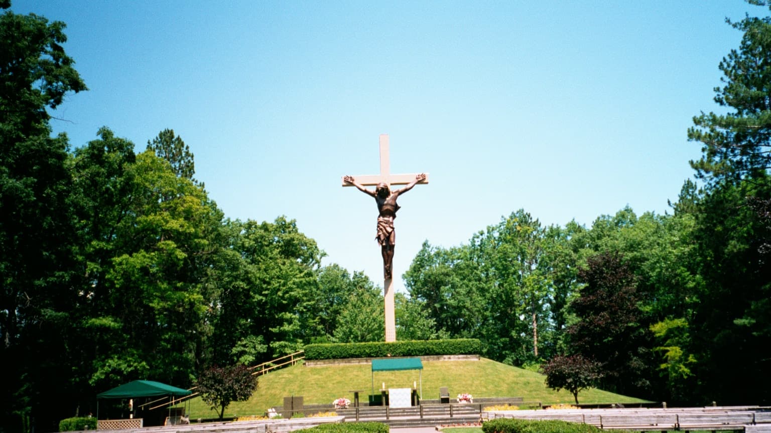
National Shrine of the Cross in the Woods, Indian River, Michigan
Indian River, Michigan, United States
125.0 km away
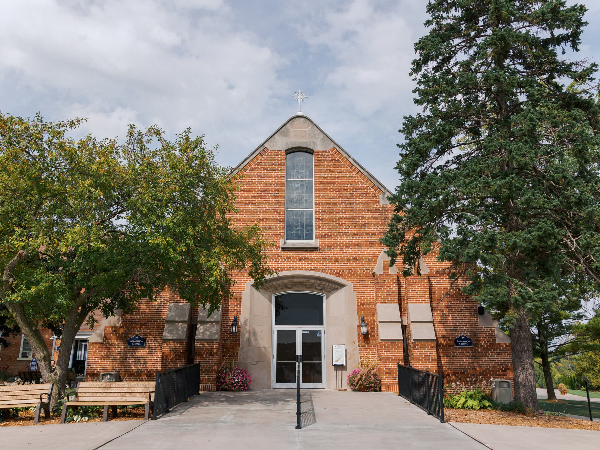
Shrine of Our Lady of Good Help
Champion, Champion, Wisconsin, United States
140.3 km away
Norton Mound Group
Grand Rapids, Michigan, United States
208.9 km away
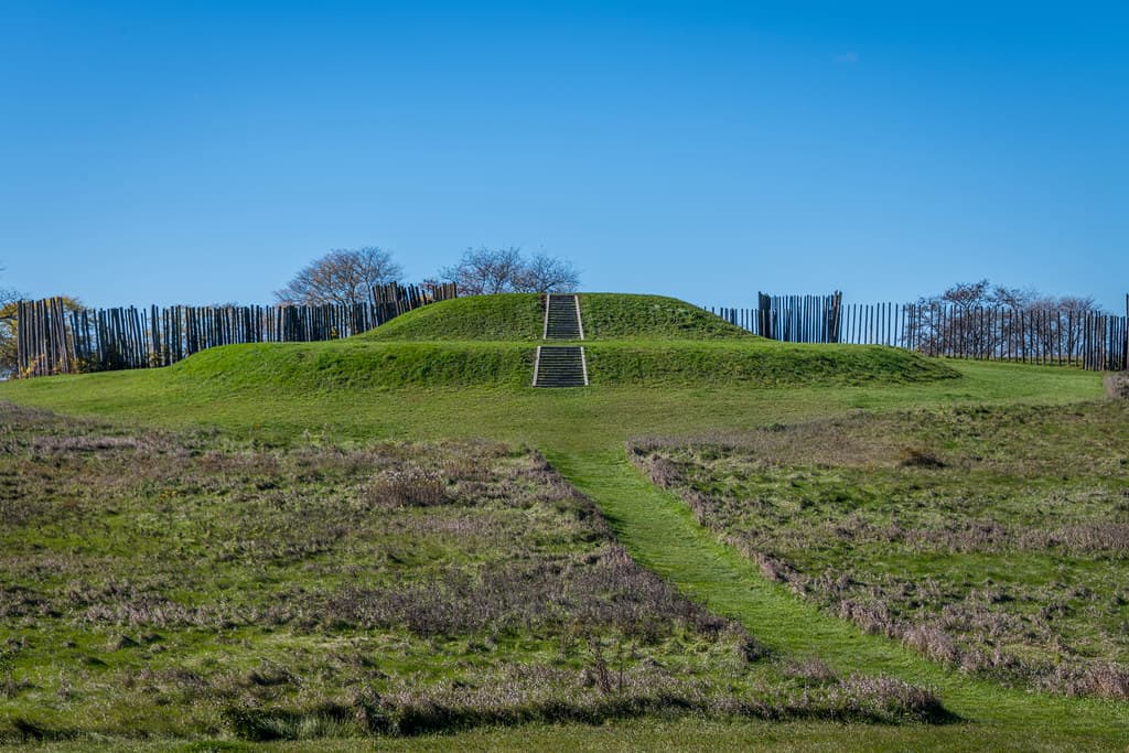
Aztalan Mounds, Wisconsin
Lake Mills, Wisconsin, United States
305.6 km away
References
Sources consulted when researching this page. Independent verification by readers is welcome.
- 01The Mother Bear and Cubs of Sleeping Bear Dunes — U.S. National Park Servicehigh-reliability
- 02Sleeping Bear Dunes National Lakeshore — Wikipedia
- 03Pure Michigan and Its Indigenous Storytellers — Midstory
Key questions
What pilgrims usually ask
- Why is Sleeping Bear Dunes, Michigan considered sacred?
- Visit Sleeping Bear Dunes National Lakeshore in Michigan. Learn the Ojibwe legend of the sleeping bear and the Manitou Islands where her cubs rest.
- What should I wear at Sleeping Bear Dunes, Michigan?
- Appropriate outdoor clothing for Great Lakes shoreline conditions. Sun protection in summer. Good shoes for dune climbing, which involves strenuous walking on loose sand. Swimwear for beach areas. The weather can change quickly; bring layers.
- Can I take photos at Sleeping Bear Dunes, Michigan?
- Photography is permitted throughout the park. Use respectfully. The landscape is both natural feature and sacred geography. Let your photographs reflect both dimensions.
- How long should I spend at Sleeping Bear Dunes, Michigan?
- A half day allows visiting the main overlooks and Dune Climb. A full day permits exploration of multiple areas plus beach time. Multiple days allow for island visits, hiking, and more contemplative engagement. A week could easily be spent exploring the full lakeshore.
- What offerings are appropriate at Sleeping Bear Dunes, Michigan?
- Not applicable for general visitors. Do not leave offerings or create makeshift shrines. The story is not yours to ritualize.
- What etiquette should visitors follow at Sleeping Bear Dunes, Michigan?
- Visitors to Sleeping Bear Dunes should respect both the natural environment and its Indigenous sacred significance. Follow park regulations, practice Leave No Trace, and approach the landscape with awareness of the story it embodies. Do not create your own rituals or appropriate Indigenous practices.
- What is the history of Sleeping Bear Dunes, Michigan?
- The legend exists in multiple versions, all sharing the same basic narrative. A mother bear and her two cubs fled a forest fire in Wisconsin. They plunged into Lake Michigan and swam toward the distant Michigan shore. The mother reached land and climbed a high bluff to watch for her children. But the cubs, exhausted by the long swim, drowned within sight of safety. The mother waited. She watched. She would not leave. Gitche Manitou, the Great Spirit, was moved by her devotion. He raised two islands from the waters where the cubs had drowned, honoring their bravery. North Manitou and South Manitou stand as their memorial. The winds buried the sleeping mother under sand, where she waits still. The story teaches multiple lessons. Love persists. Faithfulness is seen. The divine responds to devotion. Loss can be honored without being erased. The landscape embodies these teachings, making them visible to all who learn to see.
- Who is associated with Sleeping Bear Dunes, Michigan?
- The Mother Bear (Central figure of the legend), The Cubs (Central figures of the legend), Gitche Manitou (The Great Spirit), Henry Rowe Schoolcraft (Collector of Ojibwe legends)