Sarissa
Hittite storm-god city where a royal pilgrimage route still crosses the highland plateau
Sivas, Altınyayla / Başören, Turkey

Plan this visit
Practical context before you go
1–2 hours for a thorough walk of the excavated areas. Add travel time: 1.5–2 hours from Sivas city center by road.
Located 4 km west of Başören village, Altınyayla district, Sivas Province. Approximately 60 km from Sivas city center by road. Private vehicle is the only practical option — no regular public transport serves the site. The road from Altınyayla to the site passes through agricultural landscape; navigation apps may not accurately locate the site entrance.
An open archaeological site requiring care around excavation areas; no active religious protocols.
At a glance
- Coordinates
- 39.3083, 36.9097
- Type
- Hittite Cult City
- Suggested duration
- 1–2 hours for a thorough walk of the excavated areas. Add travel time: 1.5–2 hours from Sivas city center by road.
- Access
- Located 4 km west of Başören village, Altınyayla district, Sivas Province. Approximately 60 km from Sivas city center by road. Private vehicle is the only practical option — no regular public transport serves the site. The road from Altınyayla to the site passes through agricultural landscape; navigation apps may not accurately locate the site entrance.
Pilgrim tips
- No religious dress requirements. Practical outdoor clothing appropriate for exposed highland terrain at 1,500 m elevation. Sturdy footwear for uneven ground.
- Generally permitted across the site. During active excavation seasons, consult with site staff before photographing excavation trenches or finds in situ.
- Active excavation trenches may be fenced; do not enter restricted areas. The site is at 1,500 m elevation and weather can change rapidly — come prepared for wind and temperature drops. Access depends on excavation season; verify conditions with Altınyayla local authorities before a dedicated trip.
Overview
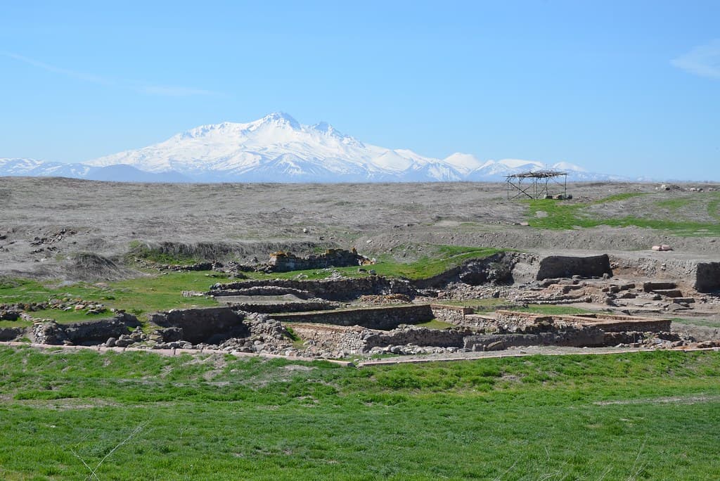
Sarissa was a royal cult city of the Hittite Empire, dedicated to the supreme Weather God. Its Storm God temple — the largest Hittite temple known — still anchors the windswept plateau where ancient kings performed seasonal rituals. Surviving festival texts allow visitors to trace the exact sacred route described 3,400 years ago.
High on the Anatolian plateau in what is now Sivas Province, the Hittite city of Sarissa occupied a strategic ridge at roughly 1,500 meters elevation. For four centuries, from approximately 1500 to 1200 BCE, it served as both a royal administrative center and one of the empire's most important religious sites — the earthly seat of Tarhunna, the Weather God who ruled storm and sky at the pinnacle of the Hittite pantheon.
The Storm God of Sarissa was so significant that he was named as a divine treaty witness in the 1285 BCE Treaty of Kadesh between the Hittites and Egypt — among the oldest known peace treaties in history. Each year, the Hittite king made a spring pilgrimage to Sarissa, approaching the god's ḫuwasi sacred standing stone by the upper road in a precisely described ritual sequence still partially recoverable from cuneiform festival texts. This rare correspondence between surviving written accounts and actual physical topography makes Sarissa exceptional: here, the ancient pilgrimage route can still be walked. German-Turkish excavations ongoing since 1992 have uncovered the temple foundations — a courtyard measuring 76 by 74 meters — and a cuneiform archive that continues to yield new insight into Hittite religious practice.
Context and lineage
Sarissa was established as a Hittite provincial center in the 16th century BCE, likely as part of the empire's expansion into what the Hittite sources called the Upper Land — the high plateau of what is now Sivas Province. The city was sacked during the turbulent period of the reign of Arnuwanda I, when the Kaska people from the north repeatedly raided deep into Hittite territory. Tudhaliya III ordered the city rebuilt and restored the cult of the Storm God, whose standing stone on the upper road was the focal point of the sacred landscape. The Storm God of Sarissa was important enough that Hattusili III — the Hittite king who negotiated the Treaty of Kadesh — named him explicitly as one of the divine witnesses guaranteeing the treaty, placing Sarissa's deity alongside the great gods of the empire in one of the most significant documents of the ancient Near East.
Hittite State Religion — Storm God (Tarhunna / Weather God) cult, part of the broader Anatolian storm-god religious tradition that extends from the Bronze Age into early Iron Age successor cultures.
Why this place is sacred
The convergence at Sarissa is unusual in the ancient world: written sacred geography and surviving landscape remain aligned. The Hittite festival texts preserved in the Hattusha archives describe the ritual approach to the Storm God's ḫuwasi stone at Sarissa — the road taken, the direction of movement, the sequence of cult acts. Stand on that same upper road today, with the plateau falling away to the south and the sky dominant in all directions, and the theological logic of this place becomes felt rather than merely understood. The Weather God who commanded storm, rain, and the fertility of crops was experienced here precisely because the site enforced this encounter: open, elevated, exposed to wind and light change, subject to the rapid atmospheric transformations of a highland climate.
The ḫuwasi — a sacred standing stone representing the god's earthly presence — was the axis around which the ritual landscape was organized. The king's annual spring visit was not merely administrative ceremony; it enacted the empire's relationship with divine power, seeking blessing for the agricultural cycle and military campaigns to come. That continuity of intent — the human being approaching the numinous, seeking alignment with cosmic forces — is what gives Sarissa its quality of thinness even in its current state of partial excavation and remote access.
Royal cult city and Weather God temple complex; seat of the annual Hittite spring festival pilgrimage.
Founded as a Hittite provincial town in the 16th century BCE, rebuilt under Tudhaliya III after a destruction event, and abandoned around 1200 BCE with the broader collapse of the Hittite Empire. The site was then unoccupied until modern archaeological investigation began in 1992.
Traditions and practice
Each year, the Hittite king traveled from the capital Hattusha to Sarissa to perform the spring festival. The ritual sequence involved a formal approach to the Storm God's ḫuwasi — a sacred standing stone on the upper road — via a prescribed route, with specific acts performed at designated points. Oracle and divination rites were conducted, including lot-casting and bird observation. Cult inventories found in the archive document the physical objects associated with the deity: statues, ritual vessels, offering supplies, and the maintenance schedules of the temple staff.
No active religious or ceremonial practices exist at the site. Ongoing archaeological fieldwork by German and Turkish teams continues in summer seasons, and the site is being developed for heritage tourism.
Approach the site from the lower road and walk uphill toward the Storm God temple along the northeast route — this approximates the ancient 'upper road' approach described in festival texts. Pause at the temple courtyard perimeter and take its scale in without crossing excavation boundaries. The wind here is constant; let it register as the Weather God's element. If festival tablets are available in published form, read the approach sequence before visiting — the correspondence between text and terrain at Sarissa is one of the most precise in the archaeological world. Visit at dawn or late afternoon when the highland light is most emphatic and the sky most active.
Hittite State Religion — Storm God Cult
HistoricalSarissa was the earthly seat of Tarhunna, the Weather God who stood at the summit of the Hittite pantheon. His Storm God temple here is the largest Hittite temple known from any excavation. The god was powerful enough to be named as a divine witness in the Treaty of Kadesh — one of the oldest international treaties in recorded history.
Annual royal spring festival; ritual approach to the ḫuwasi sacred stone on the upper road; lot oracle and bird divination; offering festivals documented in cult inventory tablets.
Archaeological and Scholarly
ActiveGerman-Turkish excavations since 1992 have made Sarissa one of only five known Hittite sites with cuneiform tablet archives. The rare alignment of festival texts with physical sacred topography makes Sarissa an exceptional case study in Bronze Age religious geography.
Annual field excavations; publication of cuneiform archives; heritage interpretation for public visitors; ongoing research by Philipps-Universität Marburg.
Experience and perspectives
Approaching Sarissa from the road out of Altınyayla, the land opens. The plateau at this elevation presents a particular quality of light — sharp, horizontal, luminous in spring and autumn, harsh at midsummer. The site itself sits on a ridge above the surrounding Anatolian countryside, and the first impression is one of scale: the excavated areas represent only a fraction of the original 12-hectare walled city, but the temple foundations of the Storm God's precinct convey genuine mass.
The temple courtyard — 76 by 74 meters — is the largest Hittite temple known from anywhere in the empire, and walking its perimeter gives a concrete sense of the institutional weight behind the Storm God cult. The mudbrick and stone foundations have been partially consolidated; what remains is enough to read the layout, to understand that this was a place of ceremony and gathering at significant scale.
Move through the site slowly. The highland wind that gives the Weather God his character here is rarely absent. The upper road toward the ḫuwasi location — though the standing stone itself is long gone — still reads as a distinct approach route when you know what to look for. Coming from the lower elevation to the higher, with the sky opening before you, the directional logic of the ancient ritual becomes legible in the body rather than only in the mind.
The cuneiform archive room, visible in excavated form, is easy to overlook but worth pausing at: this small space once contained the administrative and ritual life of a city, including the festival texts that describe the very route you are walking. For the seeker interested in the archaeology of sacred space, Sarissa offers something few sites can: a place where a specific, named ancient act of pilgrimage can be partially reconstructed from both text and terrain.
Arrive from Altınyayla via private vehicle; no visitor infrastructure on site. Walk the site perimeter clockwise from the main gate area, moving from lower to upper ground toward the Storm God temple complex. The upper road runs northeast.
Sarissa is interpreted differently depending on whether one approaches it through archaeology, Hittite religious studies, or the phenomenology of sacred landscape.
Scholars identify Sarissa as one of the five known Hittite cities with cuneiform tablet archives, making it uniquely valuable for cross-referencing ritual texts with physical remains. The temple of the Storm God at Sarissa is the largest Hittite temple yet excavated anywhere in the empire. Gernot Wilhelm's analysis of the sacred landscape of Sarissa demonstrates that the site's ritual geography was not incidental but deliberately constructed — the ḫuwasi stone, the upper road, and the approach sequence all formed an integrated sacred system described in festival texts preserved at Hattusha.
No living religious tradition survives from the Hittite period. The Storm God cult belongs entirely to the historical record. What remains is the testimony of the texts: the king came here each spring, approached the god's stone on the upper road, performed the prescribed rites, and returned. The divine presence was understood to reside in the ḫuwasi stone and in the temple — particular, localized, responsive to proper ritual address.
Researchers interested in sacred landscape geometry have noted the elevated plateau position of Sarissa and its relationship to surrounding topographic features, exploring whether the site's placement encoded cosmological orientations beyond the purely functional. The storm-god theology of the Hittites, with its emphasis on sky, weather, and agricultural fertility, resonates with comparative studies of Bronze Age highland sacred sites across Eurasia.
The full extent of Sarissa's cuneiform archive has not yet been published. The identity and specific iconography of the secondary goddess Anzili, who had her own temple at Sarissa, remains debated. The precise nature of the ḫuwasi standing stone — its material, size, and visual form — has not been established from archaeological remains. The relationship between the site's highland topography and any possible astronomical orientation of the temples is uninvestigated.
Visit planning
Located 4 km west of Başören village, Altınyayla district, Sivas Province. Approximately 60 km from Sivas city center by road. Private vehicle is the only practical option — no regular public transport serves the site. The road from Altınyayla to the site passes through agricultural landscape; navigation apps may not accurately locate the site entrance.
Altınyayla district town offers basic accommodation. Sivas city center (60 km) has a wider range of hotels and is the practical base for a day trip.
An open archaeological site requiring care around excavation areas; no active religious protocols.
No religious dress requirements. Practical outdoor clothing appropriate for exposed highland terrain at 1,500 m elevation. Sturdy footwear for uneven ground.
Generally permitted across the site. During active excavation seasons, consult with site staff before photographing excavation trenches or finds in situ.
Not applicable.
Do not enter fenced excavation trenches. Do not remove any surface material. Respect the boundaries of ongoing fieldwork and any signage from the excavation team.
Nearby sacred places
Sacred places within a half-day’s reach. Pilgrims often visit them together: walk one, stay for the other.


References
Sources consulted when researching this page. Independent verification by readers is welcome.
- 01G. Wilhelm, The Sacred landscape of Sarissa, in: Sacred Landscapes of Hittites and Luwians (Studia Asiana 9), 2015, 93-99 — Gernot Wilhelmhigh-reliability
- 02Kuşaklı-Sarissa: A Hittite Town in the Upper Land — Andreas Schachner et al.high-reliability
- 03Key Sites Of The Hittite Empire — ResearchGate contributorshigh-reliability
- 04Kuşaklı (Sarissa) - Wikipedia — Wikipedia contributors
- 053,500-year-old summer residence of Hittite kings to host visitors — Daily Sabah
- 06Sarissa | Megalithic Portal — Megalithic Portal
- 07Sarissa - Kuşaklı Hoyuk - Vici.org — Vici.org
- 08Kuşaklı | Archiqoo — Archiqoo
Key questions
What pilgrims usually ask
- Why is Sarissa considered sacred?
- Walk the 3,400-year-old royal pilgrimage route at Sarissa, the Hittite empire's largest Storm God temple on Turkey's high Anatolian plateau.
- What should I wear at Sarissa?
- No religious dress requirements. Practical outdoor clothing appropriate for exposed highland terrain at 1,500 m elevation. Sturdy footwear for uneven ground.
- Can I take photos at Sarissa?
- Generally permitted across the site. During active excavation seasons, consult with site staff before photographing excavation trenches or finds in situ.
- How long should I spend at Sarissa?
- 1–2 hours for a thorough walk of the excavated areas. Add travel time: 1.5–2 hours from Sivas city center by road.
- How do you visit Sarissa?
- Located 4 km west of Başören village, Altınyayla district, Sivas Province. Approximately 60 km from Sivas city center by road. Private vehicle is the only practical option — no regular public transport serves the site. The road from Altınyayla to the site passes through agricultural landscape; navigation apps may not accurately locate the site entrance.
- What offerings are appropriate at Sarissa?
- Not applicable.
- What etiquette should visitors follow at Sarissa?
- An open archaeological site requiring care around excavation areas; no active religious protocols.
- What is the history of Sarissa?
- Sarissa was established as a Hittite provincial center in the 16th century BCE, likely as part of the empire's expansion into what the Hittite sources called the Upper Land — the high plateau of what is now Sivas Province. The city was sacked during the turbulent period of the reign of Arnuwanda I, when the Kaska people from the north repeatedly raided deep into Hittite territory. Tudhaliya III ordered the city rebuilt and restored the cult of the Storm God, whose standing stone on the upper road was the focal point of the sacred landscape. The Storm God of Sarissa was important enough that Hattusili III — the Hittite king who negotiated the Treaty of Kadesh — named him explicitly as one of the divine witnesses guaranteeing the treaty, placing Sarissa's deity alongside the great gods of the empire in one of the most significant documents of the ancient Near East.