Hanyeri Relief
A Taurus mountain pass where Hittite princes named the mountain god and asked his permission to pass through
Tufanbeyli area, Adana, Mediterranean Region, Turkey
Plan this visit
Practical context before you go
1–2 hours; the site is roadside but requires travel to a remote mountain location. Allow 2–3 hours travel time from Kayseri (approximately 80 km).
Near Hanyeri village, approximately 800 m north of the village on the Tufanbeyli–Develi road, Tufanbeyli district, Adana Province. GPS: approximately 38.2134°N, 36.0149°E. Private vehicle required. The relief is visible from the road but set 4 m above road level. No formal parking area, visitor facilities, or signage.
A roadside open-air archaeological site at mountain altitude; observation from below is the appropriate mode of engagement.
At a glance
- Coordinates
- 38.2134, 36.0149
- Type
- Hittite Rock Relief
- Suggested duration
- 1–2 hours; the site is roadside but requires travel to a remote mountain location. Allow 2–3 hours travel time from Kayseri (approximately 80 km).
- Access
- Near Hanyeri village, approximately 800 m north of the village on the Tufanbeyli–Develi road, Tufanbeyli district, Adana Province. GPS: approximately 38.2134°N, 36.0149°E. Private vehicle required. The relief is visible from the road but set 4 m above road level. No formal parking area, visitor facilities, or signage.
Pilgrim tips
- Practical clothing for mountain weather. Even in summer the Gezbeli Pass can be cold; bring a layer.
- Photography permitted from road level. Morning light is preferred. A telephoto lens or optical zoom helps resolve detail in the upper registers from viewing distance.
- Do not attempt to climb to the relief — it is set four meters above the road on a rock face. Do not touch the carved surface. The road at the base of the carving carries traffic; exercise caution. The pass can be cold and windy at 1,960 meters even in summer.
Overview
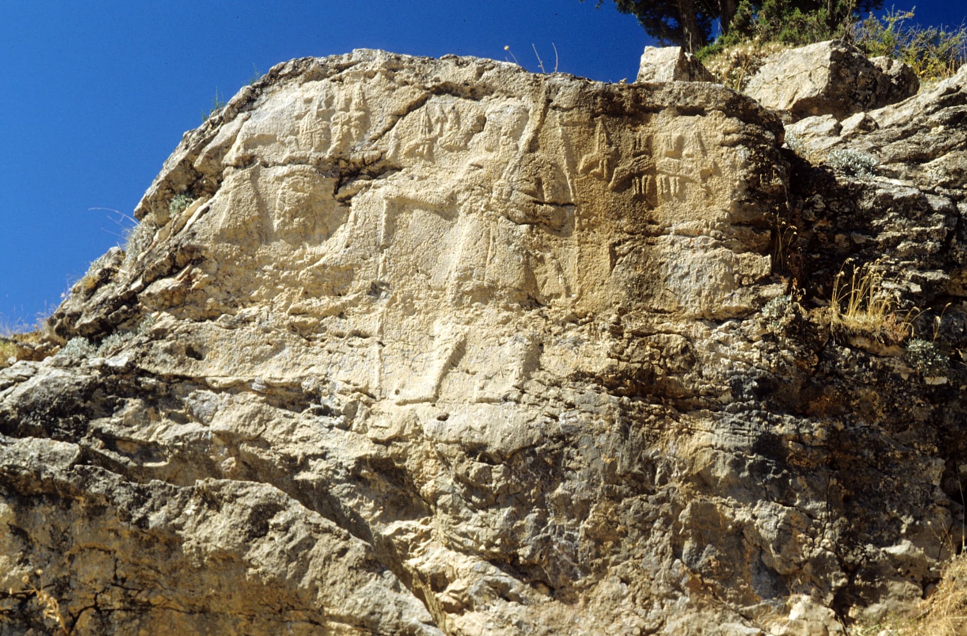
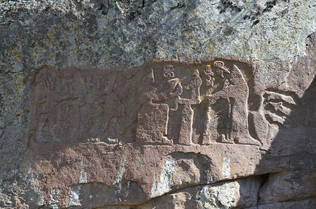
Carved four meters above a mountain road at the Gezbeli Pass in the Taurus Mountains, the Hanyeri relief names the divine owner of the mountain it occupies: Sharruma, 'King of the Mountain,' shown as a bull standing on the shoulders of mountain goddesses. Two Hittite princes — Kuwalanamuwa and Tarhuntami — placed their names and images here in the 13th century BCE, asserting that they passed through this high corridor under divine sanction.
At 1,960 meters, the Gezbeli Pass was not just a route. It was the critical gateway between the Hittite heartland and the world beyond the Taurus — Cilicia, Syria, the routes to Egypt and Mesopotamia. Everything that moved between the Hittite core and the Mediterranean passed through corridors like this one. The Hanyeri relief was carved to declare something about this passage: it was not simply crossed. It was negotiated with its divine owner.
On a rock face approximately four meters above the road between Hanyeri village and Develi, three compositional zones read from left to right. On the left: a bull standing on the shoulders of two mountain goddesses, with an inscription identifying him as Sharruma, 'King of the Mountain.' At center: Prince Kuwalanamuwa, holding bow and spear, his royal lineage marked in Luwian hieroglyphics. At right: a second inscription naming Prince Tarhuntami, possibly added after the original carving.
The Hittites named the mountain deity of this specific pass. Not a generic mountain god — this particular peak, identified in the inscription as 'Holy Sword Mountain' (likely Bey Dağı), had its divine sovereign named and carved in stone at the gate. The princes did not merely claim the pass by force. They asked permission. That the bull stands on the shoulders of mountain goddesses — elevated, held up by the feminine divine powers of the mountain itself — encodes a theology of place: the sacred geography is layered, hierarchical, specific. This pass belongs to Sharruma. These princes pass through it with his acknowledgment.
Context and lineage
The Gezbeli Pass at 1,960 meters was one of the Taurus Mountain's most important strategic corridors — the route connecting the Hittite heartland (the Kızılırmak basin and Kayseri region) with Cilicia, Syria, and the wider Near East. Military campaigns, royal processions, and trade convoys all used this corridor. Controlling the pass was a matter of imperial priority.
In the 13th century BCE, two Hittite vassal princes — Kuwalanamuwa and Tarhuntami — were active in this region. Kuwalanamuwa, who also appears at the İmamkullu relief thirty kilometers north, held authority over the mountain routes approaching the Gezbeli from the Anatolian side. Tarhuntami's precise relationship to Kuwalanamuwa is uncertain — he may have been a colleague, a successor, or a co-commissioner whose inscription was added to an existing relief.
The choice to name the mountain deity — Sharruma, King of the Mountain, associated with the peak identified as 'Holy Sword Mountain' — distinguishes Hanyeri from purely political reliefs. The relief is not simply an assertion of human authority at a pass. It is a theological statement about the nature of the pass: it is Sharruma's territory, and the princes' right of passage is acknowledged within that framework.
The relief was discovered in 1939 by Ali Rıza Yalgın, then director of the Adana Archaeology Museum, during a survey of the region. It is one of the five Hittite rock reliefs concentrated in the Zamantı/Gezbeli pass corridor, forming the densest cluster of Hittite sacred rock art in Anatolia.
The Hanyeri relief belongs to the Hittite tradition of pass consecration through royal and divine rock carving, and is part of the five-relief cluster in the Zamantı/Enzel Dere/Gezbeli corridor. Its explicit naming of a specific mountain deity makes it the most theologically articulate of the Taurus pass reliefs, and an important source for understanding how the Hittites conceptualized the sacred geography of specific landscape features.
Kuwalanamuwa
Hittite prince, named in Luwian hieroglyphic inscription; depicted at center holding bow and spear; possibly the same prince depicted at İmamkullu Relief ~30 km north
Tarhuntami
Hittite prince, named in inscription at right side of the relief; possibly added after the original carving; exact relationship to Kuwalanamuwa uncertain
Ali Rıza Yalgın
Director of the Adana Archaeology Museum; discovered the relief in 1939 during a regional survey
Why this place is sacred
What distinguishes the Hanyeri relief from most Hittite pass reliefs is the act of naming. The inscription does not just depict a mountain god — it identifies the specific divine sovereign of this specific peak: Sharruma, King of the Mountain. The mountain itself is named: Holy Sword Mountain. The relief is not simply a territorial marker placed at a strategic pass. It is a recognition of who the pass already belongs to, and an acknowledgment of that ownership by the human princes who are using it.
This represents a particular understanding of sacred landscape: the divine hierarchy is not imposed on the land from outside but discovered within it. The mountain has its own god. The pass has its own guardian. The princes' role is to acknowledge this, to place themselves in relationship to the divine sovereign of the place, and thereby to secure passage.
The bull on mountain goddesses is a Hittite cosmological image: the storm god's sacred animal, elevated on the divine feminine powers of the earth, linking sky and mountain in a single figure. At the Gezbeli Pass, this image governs the threshold between two worlds — the northern Anatolian plateau and the southern Taurus approaches. Every traveler who passed through this gate, for as long as the Hittite Empire existed, did so in the shadow of that image. The thinness of Hanyeri is not mysterious or abstract: it is carved in specific theological language at the exact physical threshold it describes.
To consecrate the Gezbeli Pass by naming its divine sovereign (Sharruma), to assert the princes' vassal authority under divine sanction, and to make the passage permanently authorized through the inscription of royal images at the gateway.
After the Hittite collapse (c. 1180 BCE), the pass remained in use — the Gezbeli route continued to connect Cilicia with the Anatolian interior through subsequent centuries. The relief remained visible on the rock face, its imagery legible even as the script became unreadable to later populations. Discovered in 1939 by Ali Rıza Yalgın, director of the Adana Archaeology Museum. Now documented in the official Turkish cultural heritage inventory and cited extensively in studies of Hittite sacred landscapes.
Traditions and practice
Hittite mountain pass religion involved the naming and propitiation of specific landscape deities — mountains, rivers, and springs each had divine identities requiring acknowledgment. The act of carving Sharruma's name and image at the Gezbeli Pass was an act of relationship: the princes acknowledged the god's sovereignty and implicitly requested passage. The bull on mountain goddesses image may have been invoked or addressed by priests or travelers passing through the corridor, though no specific ritual program at Hanyeri is documented in surviving Hittite texts.
No active practices. Occasional visits by Hittite monument specialists and cultural heritage tourists. The site is included in specialist studies of Hittite sacred landscapes.
Approach the site from the road and establish yourself at a distance that allows the full three-zone composition to be read. The bull on mountain goddesses on the left is the theologically novel element — give it sustained attention before moving to the prince and inscription at center and right. Consider what the Hittites were naming: not just a generic mountain deity but the specific divine sovereign of this specific peak. The inscription calls the mountain 'Holy Sword Mountain.' The relief is making a claim about the nature of this particular place.
Look at the bull's position — elevated on the shoulders of the mountain goddesses below him, himself identified as Sharruma. The layering is vertical: the feminine divine earth powers at the base, the mountain god above them, and by implication the sky and storm deity connected through the bull. The cosmological structure of this pass is mapped in this carving.
Then read the princes. They are not above or alongside Sharruma; they are beside him, in the same composition, acknowledged as present under his sovereignty. Their names are carved in a script that would become unreadable centuries after their deaths. The god's image — the bull, the mountain goddesses — needs no script. It communicates directly in form.
Before leaving, look at the landscape the carving overlooks: the pass descending south toward Cilicia, the mountain walls on either side, the sky above. This threshold was used for centuries after the princes' names were forgotten. The mountain was here before the carving and will be here after it weathers away.
Hittite Vassal Royal and Mountain Cult
HistoricalThe relief consecrates the Gezbeli Pass by naming its divine sovereign Sharruma (King of the Mountain) and placing vassal princes Kuwalanamuwa and Tarhuntami under his authority — the most theologically explicit of the Taurus pass reliefs in naming the specific landscape deity.
The carved names and images of the princes constituted a permanent acknowledgment of the mountain god's sovereignty and a request for divine sanction of passage through his territory.
Archaeological / Scholarly
ActiveDiscovered in 1939; part of the densest cluster of Hittite sacred rock art in Anatolia. Cited as a key source in studies of Hittite sacred landscape theology and the practice of divine landscape inscription at mountain passes.
Academic study; documented in the Turkish cultural heritage inventory; included in the scholarly volume 'Sacred Landscapes of Hittites and Luwians'; part of specialist Hittite monument tours.
Experience and perspectives
The Hanyeri relief is carved on a rock face beside the road that runs from Tufanbeyli through Hanyeri village toward Develi — the ancient Gezbeli Pass route. The carving sits approximately four meters above the current road level, which means the encounter is from below: you look up at it, as ancient travelers would have.
Approach from the road and position yourself at a distance that allows the full three-zone composition to be visible. Moving too close reduces the composition to fragments. At the right distance — perhaps fifteen to twenty meters back — the three zones read together: the bull on mountain goddesses on the left, the prince with his weapons in the center, the inscription zone on the right.
The bull figure is the most unusual element. In canonical Hittite iconography, sacred bulls appear beside the storm god — they are his vehicle and attendants. Here they elevate a bull atop mountain goddesses, creating a layered image: divine feminine power at the base, the storm god's sacred animal above it, all identified as Sharruma, King of the Mountain. This is not standard Hittite pass iconography. It is specific to this place, to this named peak, to this pass.
The rock face is exposed to the mountain environment: weathering is ongoing. The composition is legible but details require attention and good light. Morning light (the face receives morning illumination before the sun moves behind the ridge) is recommended. The Taurus landscape surrounding the pass — the depth of sky, the scale of the terrain — provides the spatial context within which the carving's ambition can be felt: the princes were inscribing themselves into a landscape far larger than they were, under the protection of a god who was the mountain itself.
GPS: approximately 38.2134°N, 36.0149°E. Near Hanyeri village on the Tufanbeyli–Develi road, approximately 800 meters north of Hanyeri village, Tufanbeyli district, Adana Province. The relief is on a rock face approximately 4 meters above the road. Best viewed from road level; do not attempt to climb to the relief.
The Hanyeri relief is the most theologically explicit of the Taurus pass reliefs — it names the mountain god and maps the divine hierarchy of the pass in a way that invites multiple frameworks for understanding what it means to consecrate a landscape.
Scholarly consensus places the relief in the 13th century BCE Hittite Empire period, commissioned by vassal princes Kuwalanamuwa and Tarhuntami. Discovered by Ali Rıza Yalgın in 1939 and subsequently documented by the Hittite Monuments Project, cultural heritage inventory, and academic studies of Hittite sacred landscapes (including the Academia.edu volume 'Sacred Landscapes of Hittites and Luwians'). The naming of Sharruma and the specific peak designation ('Holy Sword Mountain') make Hanyeri distinctive in the scholarly literature on Hittite sacred geography. Whether Kuwalanamuwa at Hanyeri is the same as at İmamkullu remains debated.
No living tradition is directly associated. The site is in a Turkish rural area with no organized Hittite descendant community. The pass continues to be used as a road route through the Taurus.
The Hanyeri relief embodies a theology of landscape that is not unique to the Hittites but finds here a particularly clear expression: the land is not neutral. It has its own sacred hierarchy. The mountain has its own god. The pass has its guardian. Human authority — even royal human authority — operates within this framework by acknowledging it, not overriding it. The princes' inscriptions do not claim the mountain; they place themselves under it. This model of sacred passage — the traveler acknowledging the divine sovereignty of the landscape they enter — is legible across many traditions and perhaps resonates in the encounter with this site today.
Whether the Tarhuntami inscription was contemporary with Kuwalanamuwa's carving or added later is uncertain. The full extent of the sacred route program connecting Hanyeri, İmamkullu, Fıraktın, and the Taşçı reliefs has not been reconstructed. The specific ritual activities enacted at the pass site are undocumented.
Visit planning
Near Hanyeri village, approximately 800 m north of the village on the Tufanbeyli–Develi road, Tufanbeyli district, Adana Province. GPS: approximately 38.2134°N, 36.0149°E. Private vehicle required. The relief is visible from the road but set 4 m above road level. No formal parking area, visitor facilities, or signage.
Kayseri (approximately 80 km north) offers full accommodation options. Tufanbeyli has very limited local options. No facilities at the pass.
A roadside open-air archaeological site at mountain altitude; observation from below is the appropriate mode of engagement.
Practical clothing for mountain weather. Even in summer the Gezbeli Pass can be cold; bring a layer.
Photography permitted from road level. Morning light is preferred. A telephoto lens or optical zoom helps resolve detail in the upper registers from viewing distance.
None appropriate.
Do not climb to the relief. Do not touch the carved surface. Exercise caution on the road.
Nearby sacred places
Sacred places within a half-day’s reach. Pilgrims often visit them together: walk one, stay for the other.
İmamkullu Relief
Tomarza area, Kayseri, Central Anatolia Region, Turkey
8.3 km away

Taşçı Reliefs
Develi area, Kayseri, Central Anatolia Region, Turkey
20.5 km away
Fıraktın Relief
Develi area, Kayseri, Central Anatolia Region, Turkey
34.1 km away
Kültepe-Kanesh
Kayseri, Kocasinan district, 20 km NE of Kayseri, Turkey
78.3 km away
References
Sources consulted when researching this page. Independent verification by readers is welcome.
- 01Hittite Monuments - Hanyeri — Hittite Monuments Projecthigh-reliability
- 02Hanyeri Rock Monument - Cultural Inventory — Kulturenvanteri.comhigh-reliability
- 03Sacred Landscapes of Hittites and Luwians — Various authorshigh-reliability
- 04Hanyeri relief - Wikipedia — Wikipedia contributors
- 05Hanyeri relief — Grokipedia — Grokipedia
- 06Hanyeri Relief | Archiqoo — Archiqoo
- 07Relief of Hanyeri - Wikidata — Wikidata contributors
Key questions
What pilgrims usually ask
- Why is Hanyeri Relief considered sacred?
- At the Gezbeli Pass in Turkey's Taurus Mountains, the Hanyeri relief names Sharruma — King of the Mountain — as the divine sovereign of a 13th-century BCE sacre
- What should I wear at Hanyeri Relief?
- Practical clothing for mountain weather. Even in summer the Gezbeli Pass can be cold; bring a layer.
- Can I take photos at Hanyeri Relief?
- Photography permitted from road level. Morning light is preferred. A telephoto lens or optical zoom helps resolve detail in the upper registers from viewing distance.
- How long should I spend at Hanyeri Relief?
- 1–2 hours; the site is roadside but requires travel to a remote mountain location. Allow 2–3 hours travel time from Kayseri (approximately 80 km).
- How do you visit Hanyeri Relief?
- Near Hanyeri village, approximately 800 m north of the village on the Tufanbeyli–Develi road, Tufanbeyli district, Adana Province. GPS: approximately 38.2134°N, 36.0149°E. Private vehicle required. The relief is visible from the road but set 4 m above road level. No formal parking area, visitor facilities, or signage.
- What offerings are appropriate at Hanyeri Relief?
- None appropriate.
- What etiquette should visitors follow at Hanyeri Relief?
- A roadside open-air archaeological site at mountain altitude; observation from below is the appropriate mode of engagement.
- What is the history of Hanyeri Relief?
- The Gezbeli Pass at 1,960 meters was one of the Taurus Mountain's most important strategic corridors — the route connecting the Hittite heartland (the Kızılırmak basin and Kayseri region) with Cilicia, Syria, and the wider Near East. Military campaigns, royal processions, and trade convoys all used this corridor. Controlling the pass was a matter of imperial priority. In the 13th century BCE, two Hittite vassal princes — Kuwalanamuwa and Tarhuntami — were active in this region. Kuwalanamuwa, who also appears at the İmamkullu relief thirty kilometers north, held authority over the mountain routes approaching the Gezbeli from the Anatolian side. Tarhuntami's precise relationship to Kuwalanamuwa is uncertain — he may have been a colleague, a successor, or a co-commissioner whose inscription was added to an existing relief. The choice to name the mountain deity — Sharruma, King of the Mountain, associated with the peak identified as 'Holy Sword Mountain' — distinguishes Hanyeri from purely political reliefs. The relief is not simply an assertion of human authority at a pass. It is a theological statement about the nature of the pass: it is Sharruma's territory, and the princes' right of passage is acknowledged within that framework. The relief was discovered in 1939 by Ali Rıza Yalgın, then director of the Adana Archaeology Museum, during a survey of the region. It is one of the five Hittite rock reliefs concentrated in the Zamantı/Gezbeli pass corridor, forming the densest cluster of Hittite sacred rock art in Anatolia.