Tapikka
Hittite frontier garrison on the empire's contested northern edge, where cuneiform tablets recorded war and chaos
Understand sacred places, explore living traditions, and learn how to engage respectfully with Pilgrim Map.
Access has not been verified. Check current local guidance before planning a visit.
Tokat, Turkey
Read the sources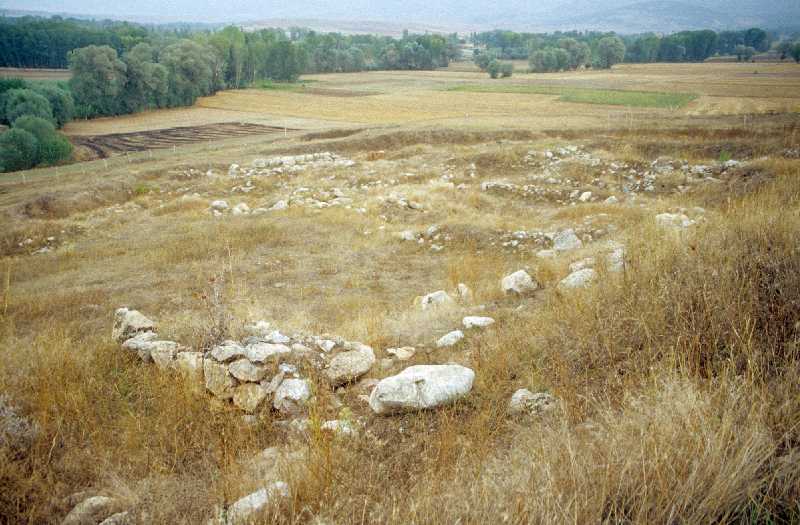
Visit essentials
A quick read before you go
- Duration
- 30–60 minutes at the site.
- Access
- Approximately 20 km south of Zile, Tokat Province.
Overview
On the high plateau south of Zile in Tokat Province, the modest tell of Maşat Höyük rises from farmland. Its 1970s cuneiform finds reveal Tapikka as the Hittite Empire's vulnerable northern frontier.
The Kaska, a non-Indo-European people of the Pontic mountains, periodically raided the Hittite heartland. Tapikka served as provincial capital, administrative-military outpost, and oracle center before and after engagements, reporting events to the king at Hattusha through one of the most important archives of Hittite imperial administration.
Dispatches from its governor to King Tudhaliya II/III record raids, losses, the city's destruction, and rebuilding under Suppiluliuma I. Written record and archaeology converge on the sustained weight of maintaining civilization at an empire's edge.
Why this place is sacred
Tapikka's significance comes from a boundary where Hittite imperial theology became lived danger. Creation myths cast order against chaos as the storm god's defeat of the primordial serpent; here that struggle took the form of Kaska raids, patrols, and anxious dispatches.
The emperor's sacred duty was to maintain agriculture, ritual, and society against dissolution. Tapikka was destroyed and rebuilt, while its garrison sustained provincial cult observances under the possibility of another northern raid in any season.
Its cuneiform letters are not hymns or ritual texts but pressured reports to a king about his most dangerous border. That urgency in clay gives the site historical intensity rather than established sanctity.
Hittite provincial administrative and military center on the northern Kaska frontier.
Early Bronze Age origins; prominent Hittite occupation from the 15th through 13th centuries BCE; destroyed by the Kaska during the reign of Tudhaliya II, rebuilt by Suppiluliuma I; abandoned around 1200 BCE with the general Hittite collapse. Site now largely under agricultural use.
Experience and orientation
South of Zile, look for a tell in cultivated land. Its measured scale—450 by 225 meters, with an upper citadel 29 meters above the plain—is less visually dramatic after decades without major excavation and renewed agricultural use.
The unobstructed mound once held a governor's palace and archive room amid the administrative, military, and religious life of a Hittite garrison town 3,400 years ago. Across the Tokat plateau, Kaska country lies north and the former road to the capital runs south and west.
Walk the perimeter slowly and read the frontier terrain as commanders did: where visibility ends, the plateau drops toward river-valley approaches, and exposure is greatest. Finds from Tapikka are held at Tokat's museum, 80 km northeast.
Located approximately 20 km south of Zile, Tokat Province. Private vehicle required. No formal visitor facilities on site; treat the mound with care for agricultural ground and archaeological surface material.
Context and lineage
The Hittite tablets from Tapikka describe a city in crisis: the Kaska people from the northern mountains had destroyed it during the reign of Tudhaliya II, leaving the governor to send desperate dispatches to the capital about lost territory and refugees. Suppiluliuma I — the great Hittite empire-builder — then ordered the city rebuilt as part of his systematic reestablishment of Hittite control over the Upper Land.
The tablets preserved at the site document this period of destruction, rebuilding, and perpetual vigilance in direct, administrative prose: not theology, but governance under existential pressure.
Hittite provincial administration and state cult; Early Bronze Age Anatolian culture preceding the Hittite period.
Traditions and practice
As a Hittite provincial capital, Tapikka would have maintained the state cult observances prescribed from Hattusha: regular offerings to the pantheon, oracle consultations using lot and bird divination before military operations, and the administrative religious calendar required of all imperial centers. The tablets document the military and administrative aspects more than the purely religious, but the two were inseparable in Hittite thought: proper ritual maintenance was understood as a prerequisite for military success.
No active religious or ceremonial practices. No formal visitor program. The site is primarily under agricultural use.
Walk the mound perimeter from the base before ascending to the citadel area. Move slowly and observe the surrounding terrain: the northern horizon, where the Kaska country began; the road south toward the Hittite heartland. The archive room on the upper citadel — whose precise location is now uncertain within the excavated area — was the nerve center of this frontier: a room where a governor translated the threats of the northern mountains into cuneiform lines addressed to the king.
Even without visible archaeological markers, the landscape logic of the site — a commanding height above the approach routes from the north — makes the garrison's strategic thinking legible.
Hittite State Religion and Administration
HistoricalAs a Hittite provincial capital, Tapikka maintained the required state cult observances. Its primary significance, however, is as a window into Hittite imperial administration at its most stressed — a frontier garrison whose cuneiform correspondence documents the empire's sustained effort to maintain order against the Kaska threat.
Standard provincial cult observances; military oracle consultations; royal correspondence.
Archaeological and Scholarly
ActiveExcavated in the 1970s by Turkish archaeologists; tablet archive published by Sedat Alp in 1991. The site's finds are held in Tokat Museum. Ongoing scholarly study of the tablet archive continues to yield insights into Hittite frontier administration.
Past excavation campaigns; ongoing study of published tablet archive.
Perspectives and open questions
Tapikka is primarily significant as an administrative-military site, but the lens through which one approaches its archaeology fundamentally shapes the experience.
Scholarly perspective
The cuneiform tablets from Tapikka, edited by Sedat Alp in 1991, are among the most important documents for understanding Hittite frontier administration and the sustained threat posed by the Kaska people. The unusual feature of the archive is its administrative rather than religious character — it provides a rare view into the practical governance of a Hittite provincial capital under military pressure. The site's identification as Tapikka is secure through both textual and geographical evidence.
Living and traditional perspectives
No living tradition is associated with the site. The Kaska people who repeatedly destroyed Tapikka left no surviving cultural memory in the region, and the Hittite administrative tradition that the site embodied ended with the empire's collapse around 1200 BCE.
Alternative interpretations
Some researchers interested in pre-Hittite Anatolian cultures have speculated about the religious traditions of the Kaska — the people who twice destroyed Tapikka. Almost nothing is known about their practices, and their periodic dominance of the site during the years between destructions and rebuilding represents a completely undocumented layer of the site's history.
Open questions
The full extent of the unexcavated lower town is unknown. The religious buildings associated with Hittite cult practice have not been identified at the site. The complete archive of tablets has not been exhaustively translated into English. The Kaska occupation phases between Hittite destructions and rebuildings remain entirely unexcavated.
Plan your visit
Access and arrival
Approximately 20 km south of Zile, Tokat Province. No regular public transport. Nearest significant city is Tokat, approximately 80 km to the northeast. Private vehicle with navigation recommended; site may not appear on mapping apps.
Tokat city, approximately 80 km to the northeast, is the practical base with hotels and full services. Zile offers more limited options.
Respectful visit
No requirements. Practical footwear for uneven mound terrain.
Permitted.
Not applicable.
Do not disturb the mound surface or remove any material, including surface sherds. Respect agricultural use of surrounding land.
Respect agricultural use of the surrounding and surface land. Do not disturb the mound surface or remove any material. No formal facilities; come prepared with water and navigation for a remote location.
Location
Map loads as you approach this section.
Pilgrim reflections
A portrait of encounter, not a score
Pilgrims describe what they felt, how present they could become, and whether the place would shape a journey. There are no stars and no ranking of traditions.
No reviewed reflections yet
The first pilgrims can help describe the character of being here.
Share a reflection
Available after an account-backed “Been there.” Every reflection is reviewed before publication.
Nearby sacred places
Explore other sacred places in the region. Proximity does not establish access or travel time; check each place’s guidance.


References
Sources consulted for this page. Source categories describe the publication, not a guarantee that every claim is verified. Traditional accounts and outside interpretations may differ.
- 01Excavations at the Hittite Site, Maşat Höyük: Palace, Archives, Mycenaean Pottery — American Journal of Archaeology, Vol 84, No 3academicPeer-reviewed report on excavation findings including Mycenaean pottery assemblage
- 02Key Sites Of The Hittite Empire — ResearchGate contributorsacademicPlaces Tapikka in context of Hittite provincial administration
- 03Maşat Höyük - Kültür Envanteri — Turkish Cultural InventoryofficialOfficial Turkish cultural heritage inventory entry
- 04Maşat Höyük - Wikipedia — Wikipedia contributorsencyclopediaOverview of site history, excavations, and tablet archive
- 05Maşat Höyük-Tapigga - Vici.org — Vici.orgSource contextGeoreferenced site entry with coordinates
- 06Tapikka - Strabon.io — Strabon.ioSource contextSite summary with historical context
- 07Masat Hoyuk [Maşat Höyük, Tabigga, Tabikka] Ancient Sites — Megalithic PortalguideSite listing with community notes
- 08Maşat Höyük | Archiqoo — ArchiqooSource contextSite summary
Share a photo
Help visitors recognize Tapikka. Every submission is reviewed before publication.