Liman Tepe
Where the oldest harbor meets the oldest world—a Bronze Age maritime gateway beneath the Aegean
İzmir, Urla, Turkey

Plan this visit
Practical context before you go
1–2 hours for a surface visit; allow additional time if excavations are active. Combine with Klazomenai (immediately adjacent) for a 3–4 hour visit.
Located on the Urla–İskele peninsula near Urla town, approximately 35 km west of İzmir city center. Accessible by car via the coastal road from Urla. Limited public transport from Urla town; dolmuş (shared taxi) service is intermittent. The İzmir Archaeology Museum (Konak district, central İzmir) houses major finds including items from both Liman Tepe and Klazomenai and is more accessible for most visitors. Mobile phone signal may be unreliable in parts of the peninsula; confirm access arrangements in advance. No current contact information was available at time of writing; check the Turkish Ministry of Culture website for current visitor details.
Liman Tepe is an active archaeological site under Turkish state protection; visitors are welcome but should follow site protocols.
At a glance
- Coordinates
- 38.3623, 26.7759
- Type
- Bronze Age Settlement
- Suggested duration
- 1–2 hours for a surface visit; allow additional time if excavations are active. Combine with Klazomenai (immediately adjacent) for a 3–4 hour visit.
- Access
- Located on the Urla–İskele peninsula near Urla town, approximately 35 km west of İzmir city center. Accessible by car via the coastal road from Urla. Limited public transport from Urla town; dolmuş (shared taxi) service is intermittent. The İzmir Archaeology Museum (Konak district, central İzmir) houses major finds including items from both Liman Tepe and Klazomenai and is more accessible for most visitors. Mobile phone signal may be unreliable in parts of the peninsula; confirm access arrangements in advance. No current contact information was available at time of writing; check the Turkish Ministry of Culture website for current visitor details.
Pilgrim tips
- No religious dress requirements. Sturdy footwear is recommended for uneven archaeological terrain. Sun protection is advisable in summer.
- Generally permitted across the site. Check with excavation team members during active seasons regarding photography near open trenches.
- The underwater portions of the site are accessible only to authorized archaeological researchers. Do not enter excavation trenches. Stay on designated paths.
Overview
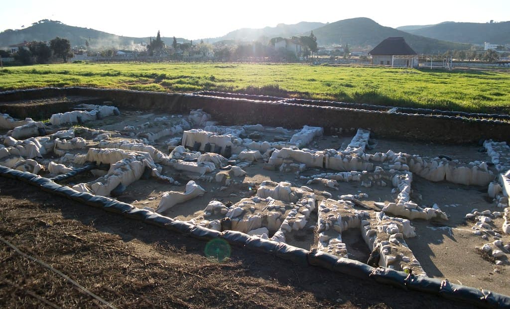
Liman Tepe is a prehistoric coastal tell on the Urla peninsula of western Turkey, settled continuously from the Neolithic through the Bronze Age. Its partially submerged ruins include one of the ancient world's earliest harbor complexes and evidence of organized ritual practices—animal sacrifice, communal feasting, megaron gatherings—that mark it as a place where maritime trade and ceremonial life were inseparable.
The mound rises from the Urla peninsula above Izmir Bay, a layer-cake of human habitation stretching back to the Neolithic. What draws researchers here is not a single monument or deity but a sustained pattern of life and death at the edge of the sea: harbor walls that once guided Bronze Age ships, ritual pits filled with the remains of carefully arranged animal sacrifices, and megaron structures suggesting communal gatherings beyond the merely domestic. Much of the site continues beneath the water's surface, visible only to authorized diving archaeologists. The world's oldest known wooden anchor was recovered from these submerged layers. Standing on the mound, looking across Izmir Bay toward the mountains of the Aegean hinterland, one grasps the site's essential nature: a threshold, where land gave way to sea, where the known world gave way to trade routes that connected early Anatolia to Egypt, the Levant, and the Aegean. The ritual practices documented here—sacrificial deposits, the separation and arrangement of animal remains, the shift from residential to ceremonial use of the hilltop after the trading network collapse around 2000 BCE—suggest a community that understood its precarious position at the edge of things and tried to hold the cosmos together through repeated, careful acts of offering.
Context and lineage
The site shows occupation from as far back as the Neolithic (with some estimates suggesting as early as 9600 BCE, though more conservative dating places the main Neolithic phase between 5600 and 3000 BCE). The Chalcolithic period saw continuing settlement, followed by the Early Bronze Age (c. 3000–2000 BCE), when Liman Tepe reached its greatest extent and influence as a maritime hub. Its harbor complex—including stone jetties and wooden anchoring systems—served trade networks that connected western Anatolia with Cyprus, the Aegean islands, and the eastern Mediterranean. After the collapse of these networks around 2000 BCE, the settlement contracted and the hilltop shifted from residential to ritual use. The site was eventually succeeded by the Ionian Greek city of Klazomenai, which occupied adjacent territory and may have incorporated descendants of the Bronze Age population.
Bronze Age Anatolian Religion → collapse and abandonment → succeeded by Ionian Greek Klazomenai
Ekrem Akurgal
Turkish archaeologist who identified and first investigated the site in 1950
Hayat Erkanal
Led systematic excavations from 1992; directed both land and underwater research programs
Why this place is sacred
The quality of Liman Tepe as a liminal space derives from its physical position: a peninsula jutting into Izmir Bay where Anatolia reaches toward the Aegean, and where, five thousand years ago, ships loaded and unloaded cargoes that circulated across the early Mediterranean world. The land here does not simply end at the water; it continues underwater, carrying Bronze Age harbor walls, wooden anchors, and traces of the port infrastructure that sustained one of the ancient world's significant maritime communities. This continuity of the sacred into the submerged—into what is now hidden, inaccessible, and dark—gives the site a particular character. The ritual pits discovered in the citadel area compound this quality. Researchers have found animal sacrifices in which different body parts were deposited separately, suggesting a ritualized butchering practice rather than straightforward disposal. After the collapse of the Bronze Age trading network around 2000 BCE, the hilltop ceased to function as a residential area and became instead a place of communal feasting and gathering—as if, stripped of its commercial function, the community reclaimed the height as a purely ceremonial space. The accumulation of these layers—Neolithic settlement, Bronze Age harbor, ritual hilltop, eventual abandonment, and now underwater archaeology—creates what archaeologists call a palimpsest: a landscape where each layer of meaning partially erases and partially preserves the one beneath.
Major maritime trading hub and coastal settlement, with ritual activity concentrated in the citadel area. Harbor facilities served Bronze Age Anatolian trade networks connecting to the Aegean and eastern Mediterranean.
From Neolithic settlement to Chalcolithic community to major Early Bronze Age port, then a shift around 2000 BCE from residential to ceremonial use of the hilltop following the Bronze Age trading network collapse. Eventually abandoned as the nearby city of Klazomenai assumed the role of the area's main settlement.
Traditions and practice
The ritual pits of the citadel area received animal offerings in which different body parts were deposited separately—pig sacrifices with limbs arranged deliberately, suggesting a formalized protocol rather than casual disposal. This practice belongs to a pattern documented at several western Anatolian sites in the first half of the second millennium BCE. After 2000 BCE, the hilltop megaron structures hosted communal feasting that appeared to have replaced residential activities, suggesting the height became a shared ceremonial space following the trading network's collapse.
Annual archaeological excavations, both land-based and underwater, are conducted by Turkish universities and international research teams. Significant finds are housed in the İzmir Archaeology Museum.
Stand on the mound and face the water. Let your gaze move from the shoreline to the horizon and back. The harbor walls that once guided Bronze Age ships continue somewhere beneath the bay's surface—a fact that reframes what is visible as only part of what exists. If you can time a visit during an active excavation season, observe the work without disrupting it: the deliberate pace of archaeological recovery, the careful sieving of soil, the documentation of context before any object is removed. These acts of patient attention carry something of the ritual care that Bronze Age communities invested in the deposition of offerings. The mound itself repays circumambulation—walking its perimeter gives a physical sense of the site's relationship to the surrounding landscape and the water below.
Bronze Age Anatolian Religion
HistoricalLiman Tepe preserves evidence of organized ritual practices from the Early and Middle Bronze Age, including sacrificial animal deposits in which different body parts were arranged deliberately, and megaron structures associated with communal or ceremonial gatherings.
Ritual pits in the citadel area received animal offerings with separated body parts, suggesting formalized protocols. Communal feasting replaced residential activities on the hilltop after the trading network collapse around 2000 BCE.
Archaeological Heritage
ActiveOne of the most important prehistoric coastal settlements in western Anatolia. Ongoing excavations since 1979 have revealed the world's oldest wooden anchor and cultural layers spanning over 5,300 years.
Annual land and underwater excavation seasons conducted by Turkish universities and international teams. Artifacts displayed at İzmir Archaeology Museum.
Experience and perspectives
The site presents itself differently from most ancient places. There is no single monument to orient around, no theatrical ruin that reads immediately across a landscape. Instead, Liman Tepe rewards a slower kind of attention. Walk the perimeter of the mound and notice how the land drops toward the water—how the ancient harbor infrastructure continues below the current shoreline into the bay. The relationship between the mound's height and the water's surface is itself informative: the Bronze Age people who built here chose a position that allowed them to see ships approaching from a distance while remaining defensible from the land. During active excavation seasons, it may be possible to observe field archaeologists at work, which adds a different temporal layer to the visit—the ongoing act of recovery. The surrounding landscape of the Urla peninsula, with its olive groves and vineyards growing in stony soil, carries something of the Bronze Age agricultural hinterland that would have supplied this coastal community.
The site is located on the Urla peninsula, a coastal promontory approximately 35 km west of Izmir. The mound is adjacent to the shoreline. Combine with a visit to the nearby Klazomenai ruins for a fuller picture of the area's long habitation sequence.
Liman Tepe is primarily understood through archaeological interpretation, with no surviving indigenous tradition or mythology. Three frameworks offer distinct angles on what this site represents.
Archaeologists understand Liman Tepe as one of the most important prehistoric coastal settlements in western Anatolia—a major Early Bronze Age harbor serving the maritime trade networks that connected Anatolia to the Aegean, Cyprus, and the Levant. The discovery of the world's oldest known wooden anchor and the identification of ritual pit deposits complicate the simple narrative of a trading post: this was a community that organized both commerce and cosmology around its position at the edge of the sea. The underwater archaeology program, directed from the 1990s onward, continues to reveal submerged harbor infrastructure extending offshore.
No surviving indigenous or traditional interpretation exists for Liman Tepe. All understanding of the site's meaning to its original inhabitants must be reconstructed from archaeological evidence alone—the spatial arrangement of ritual deposits, the architectural choices of the megaron builders, the selection of offerings. This interpretive gap is itself significant: we are reading a language without a dictionary.
The site's extreme age and maritime position have attracted interest from researchers exploring the origins of Aegean religious practices and Bronze Age seafaring spirituality. The convergence of trade and ritual at coastal threshold sites—where the land-bound world gave way to the unpredictable sea—has been proposed as a formative context for early Mediterranean religious consciousness.
The full extent of the underwater archaeological zone remains uncharted. The identity and cultural affiliation of the Neolithic and early Chalcolithic inhabitants has not been fully established. The precise relationship between the ritual pit practices documented here and comparable deposits at other western Anatolian sites is still being studied. The mechanisms of the site's eventual abandonment and transition to Klazomenai are not fully understood.
Visit planning
Located on the Urla–İskele peninsula near Urla town, approximately 35 km west of İzmir city center. Accessible by car via the coastal road from Urla. Limited public transport from Urla town; dolmuş (shared taxi) service is intermittent. The İzmir Archaeology Museum (Konak district, central İzmir) houses major finds including items from both Liman Tepe and Klazomenai and is more accessible for most visitors. Mobile phone signal may be unreliable in parts of the peninsula; confirm access arrangements in advance. No current contact information was available at time of writing; check the Turkish Ministry of Culture website for current visitor details.
Urla town (c. 5 km) offers local hotels and guesthouses. İzmir city (35 km) provides the full range of accommodation options.
Liman Tepe is an active archaeological site under Turkish state protection; visitors are welcome but should follow site protocols.
No religious dress requirements. Sturdy footwear is recommended for uneven archaeological terrain. Sun protection is advisable in summer.
Generally permitted across the site. Check with excavation team members during active seasons regarding photography near open trenches.
None appropriate.
Stay on designated paths. Do not enter active excavation trenches. Do not remove any material from the site. The underwater zone is restricted to authorized researchers only.
Nearby sacred places
Sacred places within a half-day’s reach. Pilgrims often visit them together: walk one, stay for the other.


References
Sources consulted when researching this page. Independent verification by readers is welcome.
- 01Liman Tepe: A bridge between worlds — The Past Magazinehigh-reliability
- 02Worlds beneath the waves: Seeking the submerged story of Liman Tepe — The Past Magazinehigh-reliability
- 03Liman Tepe - Luwian Studies — Luwian Studieshigh-reliability
- 04The Latest Underwater Discoveries - Liman Tepe Harbor — Archaeology Magazinehigh-reliability
- 05Secrets Buried in the Pits: Ritual Activities in Western Anatolia in the First Half of the Second Millennium BCE — Cambridge Archaeological Journalhigh-reliability
- 06Limantepe - Wikipedia — Wikipedia contributors
- 07Underwater archaeologists reveal 5,300-year layers at Liman Tepe in Izmir's ancient port — Türkiye Today
- 08Limantepe - Urla - Vici.org — Vici.org
Key questions
What pilgrims usually ask
- Why is Liman Tepe considered sacred?
- Liman Tepe on Turkey's Urla peninsula holds 5,300 years of coastal life—Bronze Age harbor walls, ritual sacrifice pits, and the world's oldest wooden anchor.
- What should I wear at Liman Tepe?
- No religious dress requirements. Sturdy footwear is recommended for uneven archaeological terrain. Sun protection is advisable in summer.
- Can I take photos at Liman Tepe?
- Generally permitted across the site. Check with excavation team members during active seasons regarding photography near open trenches.
- How long should I spend at Liman Tepe?
- 1–2 hours for a surface visit; allow additional time if excavations are active. Combine with Klazomenai (immediately adjacent) for a 3–4 hour visit.
- How do you visit Liman Tepe?
- Located on the Urla–İskele peninsula near Urla town, approximately 35 km west of İzmir city center. Accessible by car via the coastal road from Urla. Limited public transport from Urla town; dolmuş (shared taxi) service is intermittent. The İzmir Archaeology Museum (Konak district, central İzmir) houses major finds including items from both Liman Tepe and Klazomenai and is more accessible for most visitors. Mobile phone signal may be unreliable in parts of the peninsula; confirm access arrangements in advance. No current contact information was available at time of writing; check the Turkish Ministry of Culture website for current visitor details.
- What offerings are appropriate at Liman Tepe?
- None appropriate.
- What etiquette should visitors follow at Liman Tepe?
- Liman Tepe is an active archaeological site under Turkish state protection; visitors are welcome but should follow site protocols.
- What is the history of Liman Tepe?
- The site shows occupation from as far back as the Neolithic (with some estimates suggesting as early as 9600 BCE, though more conservative dating places the main Neolithic phase between 5600 and 3000 BCE). The Chalcolithic period saw continuing settlement, followed by the Early Bronze Age (c. 3000–2000 BCE), when Liman Tepe reached its greatest extent and influence as a maritime hub. Its harbor complex—including stone jetties and wooden anchoring systems—served trade networks that connected western Anatolia with Cyprus, the Aegean islands, and the eastern Mediterranean. After the collapse of these networks around 2000 BCE, the settlement contracted and the hilltop shifted from residential to ritual use. The site was eventually succeeded by the Ionian Greek city of Klazomenai, which occupied adjacent territory and may have incorporated descendants of the Bronze Age population.