İmamkullu Relief
The Thunder God rides above a Hittite prince at the mountain pass where lightning was remembered as divine
Tomarza area, Kayseri, Central Anatolia Region, Turkey
Plan this visit
Practical context before you go
1–2 hours at the site. Allow significant travel time from Kayseri (approximately 60–90 minutes to Tomarza district).
Near İmamkullu village, Tomarza district, Kayseri Province. GPS: approximately 38.2464°N, 35.9292°E. Private vehicle required to reach the area; final approach on foot across rural mountain terrain. No formal visitor facilities. A cast of the relief is displayed outside the Archaeological Museum of Kayseri in the city center — this is the recommended first stop for context.
A remote open-air archaeological site at mountain elevation; the worn carved surface requires particular care.
At a glance
- Coordinates
- 38.2464, 35.9292
- Type
- Hittite Rock Relief
- Suggested duration
- 1–2 hours at the site. Allow significant travel time from Kayseri (approximately 60–90 minutes to Tomarza district).
- Access
- Near İmamkullu village, Tomarza district, Kayseri Province. GPS: approximately 38.2464°N, 35.9292°E. Private vehicle required to reach the area; final approach on foot across rural mountain terrain. No formal visitor facilities. A cast of the relief is displayed outside the Archaeological Museum of Kayseri in the city center — this is the recommended first stop for context.
Pilgrim tips
- Practical clothing for rural mountain terrain. The altitude (Bey Dağı flank) means temperatures can drop sharply; bring layers.
- Photography permitted. The northwest-facing surface is best captured in morning light. Photographic enhancement may help reveal the more worn hieroglyphic inscription. The cast at Kayseri Museum provides a clearer view of the composition.
- The carving is heavily worn — do not touch. High altitude and mountain weather; dress appropriately. No facilities. Remote location requires navigation and self-sufficiency.
Overview
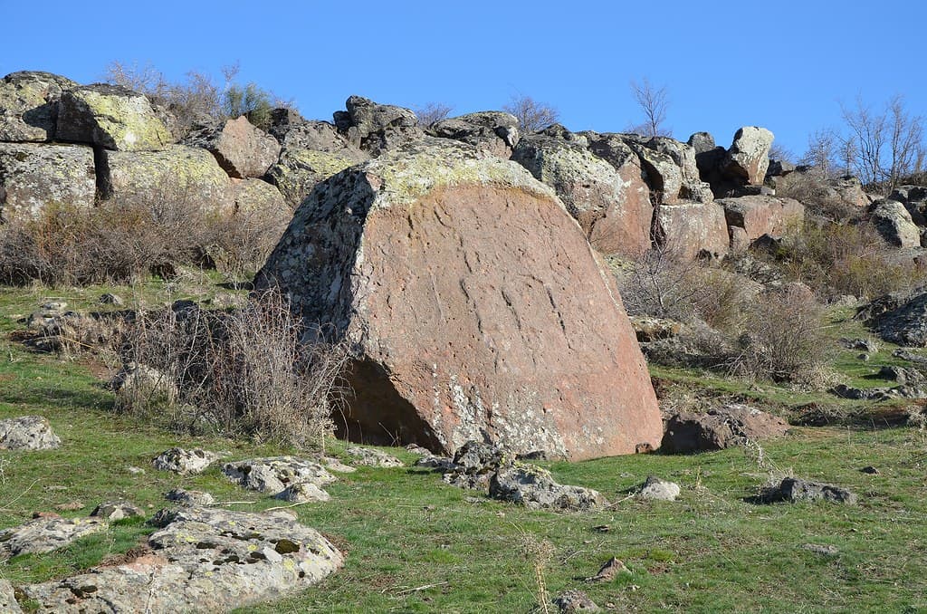
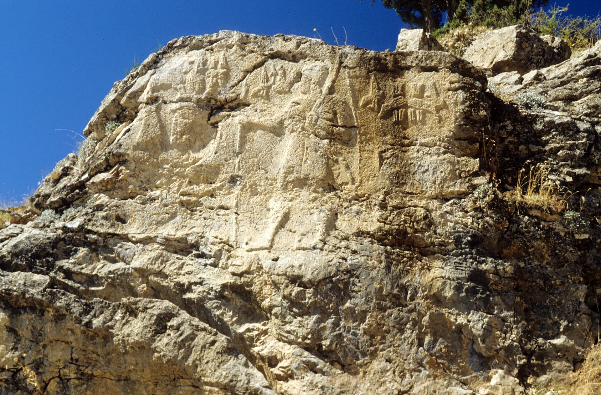
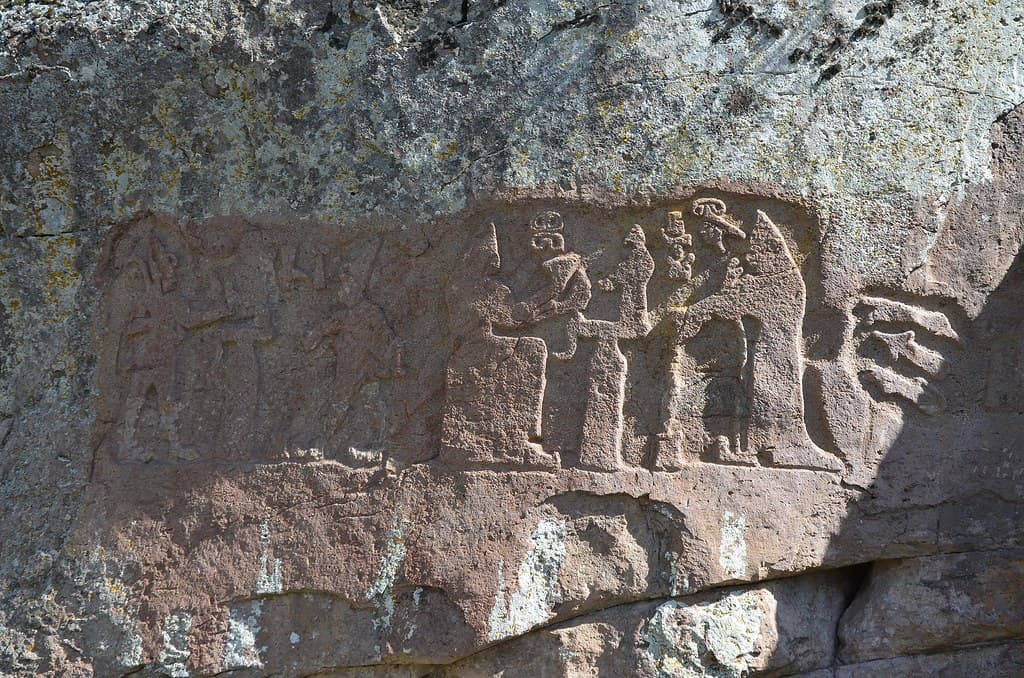
On the flank of Bey Dağı in Kayseri's Tomarza district, a trachyte boulder carries the most dynamic image in Hittite rock art: the Thunder God Teshub riding his chariot drawn by sacred bulls across the upper register, while Prince Kuwalanamuwa stands below with spear and bow. The site is still called Şimşekkaya — Lightning Rock — by locals, a name that preserves something of the site's original character across three millennia.
When the Hittites wanted to show that a place was under divine protection, they carved the god there. At what is now called the İmamkullu Relief on the southern flank of Bey Dağı, they did this with unusual force. The upper register of the carved trachyte boulder shows Teshub, the Thunder God — chief deity of the Hittite pantheon — in full motion: riding a chariot pulled by his two sacred bulls Herri and Serri, wearing a horned pointed hat, carrying his mace. This is not a static deity receiving worship. This is a god in movement, crossing the sky above the Gezbeli Pass.
Below him, in the lower register, stands Prince Kuwalanamuwa — identified by Luwian hieroglyphics as a son of the Hittite king — holding spear and bow in the posture of royal and military readiness. The composition is a cosmogram: god above, prince below, the divine hierarchy made visible in stone at the convergence of two major Taurus Mountain routes.
The local name for this boulder — Şimşekkaya, Lightning Rock — is not recorded in any Hittite text. It is a Turkish folk name, applied at some point in the millennia after the Hittite Empire fell. But the choice of name is revealing: something about this carved stone, on the flank of this mountain, in this landscape charged with storms coming off the Taurus, kept the sense of lightning and thunder alive in the place's identity. The god in the chariot is still here.
Context and lineage
In the 13th century BCE, the Hittite Empire maintained its connectivity between the Anatolian heartland and the southern approaches to Cilicia through a network of mountain passes in the Taurus. The Gezbeli Pass area, where the routes from Kayseri-Tomarza and Cappadocia-Develi converge, was a strategic junction requiring both administrative and sacred attention.
Prince Kuwalanamuwa — identified by Luwian hieroglyphic inscription as 'son of the king' — commissioned the carving of this boulder on the southern flank of Bey Dağı, above the pass convergence. The composition he chose was specific and meaningful: the Thunder God Teshub driving his chariot across the upper half, himself standing below with weapons of authority. The vertical cosmogram asserted both his royal legitimacy (son of the king, under the protection of the chief deity) and Teshub's sovereign presence over the route.
Kuwalanamuwa appears to be the same prince who commissioned or is depicted at the Hanyeri relief, approximately 30 kilometers south at the Gezbeli Pass itself. If so, his presence at both ends of the same route — at the convergence approaching the pass and at the pass summit — suggests a deliberate program of sacred landscape inscription along this entire mountain corridor.
The relief was discovered in 1934 by Kemaleddin Karamete, a resident of Kayseri, and first published by French orientalist Louis Delaporte in 1935.
The İmamkullu relief is one of five Hittite rock reliefs in the Zamantı Irmağı / Enzel Dere basin (with Fıraktın, Hanyeri, and the two Taşçı reliefs), forming the most concentrated cluster of Hittite sacred rock art in Anatolia. The valley system connects the Hittite approach from the north with the Taurus passes leading to Cilicia and Syria.
Kuwalanamuwa
Hittite prince ('son of the king') depicted in the lower register; identified by Luwian hieroglyphic inscription; possibly the same prince appearing at the Hanyeri relief
Kemaleddin Karamete
Kayseri resident who discovered the relief and brought it to scholarly attention in 1934
Louis Delaporte
French orientalist who published the first scholarly account of the relief in 1935
Ignace Gelb
American orientalist who visited and documented the site in 1935
Why this place is sacred
The Gezbeli Pass sits at the convergence of two major routes: the road from the Hittite heartland through Kayseri and Tomarza, and the road from Cappadocia through Develi. Whatever moved between the Hittite core and the Taurus approaches — armies, merchants, messengers, royal processions — passed through this intersection. It was one of the hinge points of the empire's connectivity with its southern and eastern reaches.
For the Hittites, such hinge points required divine sanction. The carving of Teshub in full motion above the pass entrance is not decoration — it is the installation of divine authority over the convergence point. The god's chariot moves across the sky above the pass; everything below, including the prince who commissioned the carving, travels under Teshub's aegis.
The local folk name Şimşekkaya (Lightning Rock) suggests that the site's connection to storms and sky power was not lost when the Hittite tradition itself was forgotten. The mountain above — Bey Dağı at 3,045 meters — generates its own weather. Lightning would have been a regular presence on this flank. That the site was named for lightning rather than for the human prince or the lost Hittite inscription indicates that whatever numinous quality the place carried, it survived in the landscape itself long after the civilization that articulated it in the carved figures had disappeared.
To consecrate the convergence of two Taurus Mountain pass routes by installing the Thunder God's image above the passage, asserting divine protection and the prince's authority under divine sanction over this strategic threshold.
After the Hittite Empire's collapse around 1180 BCE, the site lost its institutional context but retained its presence in the landscape. Discovered in 1934 by local resident Kemaleddin Karamete and published by Louis Delaporte in 1935 — the first formal scholarly record. A cast was made and is displayed outside the Archaeological Museum of Kayseri. The carved surface is described as heavily worn by natural weathering. The folk name Şimşekkaya (Lightning Rock) predates the modern rediscovery and may reflect long local awareness of the site.
Traditions and practice
In Hittite theology, the carved image of a prince standing before the Thunder God was not merely representation but enactment: the prince's presence, frozen in stone, continued to invoke Teshub's protection at this pass as long as the stone endured. There was no need for the relief to be re-activated by ceremony — it was permanently active. That said, pass reliefs were likely visited by officials, priests, or royal representatives traveling through the routes, and brief invocations or offerings at the carved surface are probable, though no specific ceremonies at İmamkullu are recorded.
No active practices. Heritage tourism and specialist Hittite monument visits; cast viewable at the Archaeological Museum of Kayseri.
Approach the boulder from below. The two-register composition resolves as you get close: the god's chariot in the upper half first, then the prince below him. Read the upper register before the lower — give Teshub the attention the carving's compositional hierarchy demands. The depiction of the Thunder God in motion (not seated, not static) is rare; this is one of the most dynamic images in Hittite rock art.
Then read the lower register: Kuwalanamuwa with his weapons, identified by the Luwian hieroglyphics that run beside him. Consider what it meant to commission this carving at this specific location — the convergence of two routes, on the flank of a 3,045-meter mountain that would itself have generated storms and lightning regularly. The god in the chariot is the appropriate divine resident of this landscape.
The folk name Şimşekkaya (Lightning Rock) is worth holding. It is not from the Hittite period; it came later, from a population that did not know the carved figures' names or histories. But they recognized something in this place — on this exposed mountain flank, beside a carving they could not read — and named it for lightning. Stand on the boulder's slope in a storm-light and consider that naming.
Hittite Royal Military-Divine Cult
HistoricalThe relief consecrates the convergence of two Taurus Mountain routes by carving the Thunder God Teshub in motion above Prince Kuwalanamuwa, asserting divine protection over the strategic pass junction. The folk name Şimşekkaya (Lightning Rock) preserves a memory of the site's sacred character.
The carved image functioned as a permanent ritual act — the prince's image before Teshub constituted an ongoing divine invocation at the pass entrance, requiring no re-enactment.
Archaeological / Scholarly
ActiveOne of five Hittite reliefs in the densest concentration of Hittite sacred rock art in Anatolia. Discovery and publication (Delaporte, 1935) were early contributions to mapping the Hittite sacred landscape in the Taurus corridor.
Academic fieldwork; cast displayed outside the Archaeological Museum of Kayseri; part of specialist Hittite monument tours.
Experience and perspectives
The İmamkullu relief sits on the southern flank of Bey Dağı at elevation, in the Tomarza district of Kayseri Province. The approach is rural — farmland, mountain slopes, the absence of visitor infrastructure. The boulder itself is trachyte (volcanic rock), roughly 3.25 meters wide by 2 meters high, with the carved surface facing northwest on a slightly convex but roughly flat face.
The two-register composition is immediately legible even before the details become clear. Upper half: a figure in motion, in a chariot, with animals pulling it. Lower half: a standing human figure in formal posture. The vertical division maps directly onto the Hittite cosmological hierarchy: the divine realm above, the human world below, sharing the same stone.
As you approach, the upper register clarifies. The Thunder God Teshub is not seated but moving — his chariot and bulls convey kinetic energy unusual in Hittite rock art, most of which favors formal stasis. The horned conical hat marks his divine status unambiguously. Below, Kuwalanamuwa's hieroglyphic inscription identifies him as a royal son. The Luwian hieroglyphics are worn; bringing a rubbing or photographic enhancement helps.
The mountain above the site is a presence. Bey Dağı at 3,045 meters dominates the landscape to the north. Stand with your back to the carving and look at what the site overlooks — the valley, the pass convergence, the routes disappearing south toward the Taurus. The relief watches what it was carved to sanction: movement through a pass under divine authority.
GPS: approximately 38.2464°N, 35.9292°E. Near İmamkullu village in Tomarza district, Kayseri Province. No formal visitor facilities at the site. A cast of the relief is displayed outside the Archaeological Museum of Kayseri in the city center.
The İmamkullu relief is an unusually legible example of how the Hittites used carved stone to assert the divine ordering of a landscape — the Thunder God above and the prince below is a cosmological statement as much as a political one.
Scholarly consensus dates the relief to the 13th century BCE Hittite Empire period, New Kingdom. Kuwalanamuwa is identified by Luwian hieroglyphics as a royal prince; his possible appearance at the Hanyeri relief (also naming Kuwalanamuwa) suggests a connected program of sacred landscape inscription along the Taurus pass routes. The site was discovered in 1934, published by Delaporte in 1935, and has been documented by the Hittite Monuments Project and the Turkish cultural heritage inventory (Kulturenvanteri).
No living tradition is directly associated. The folk name Şimşekkaya (Lightning Rock) represents a pre-modern layer of recognition that survived the transition to Turkish-speaking culture in Anatolia, though without knowledge of the carved figures' identities.
The two-register composition can be read as a vertical map of the cosmos: divine authority in motion above, human authority in service below, both occupying the same stone at the same mountain pass. This is not merely religious iconography — it is an expression of how the Hittites understood the relationship between divine and human power to be structured spatially and literally. The relief makes that structure visible in the same landscape it governed.
Whether Kuwalanamuwa at İmamkullu and Kuwalanamuwa at Hanyeri are the same individual remains debated. The full sacred program linking the five Zamantı valley reliefs has not been reconstructed. The original ritual activities enacted at the carved surface are undocumented.
Visit planning
Near İmamkullu village, Tomarza district, Kayseri Province. GPS: approximately 38.2464°N, 35.9292°E. Private vehicle required to reach the area; final approach on foot across rural mountain terrain. No formal visitor facilities. A cast of the relief is displayed outside the Archaeological Museum of Kayseri in the city center — this is the recommended first stop for context.
Kayseri city offers full accommodation options. Tomarza district has no tourist accommodation. No facilities near the site.
A remote open-air archaeological site at mountain elevation; the worn carved surface requires particular care.
Practical clothing for rural mountain terrain. The altitude (Bey Dağı flank) means temperatures can drop sharply; bring layers.
Photography permitted. The northwest-facing surface is best captured in morning light. Photographic enhancement may help reveal the more worn hieroglyphic inscription. The cast at Kayseri Museum provides a clearer view of the composition.
None appropriate.
Do not touch the carved surface, which is already extensively worn by natural weathering. Do not attempt to clear lichen or debris from the surface.
Nearby sacred places
Sacred places within a half-day’s reach. Pilgrims often visit them together: walk one, stay for the other.
Hanyeri Relief
Tufanbeyli area, Adana, Mediterranean Region, Turkey
8.3 km away

Taşçı Reliefs
Develi area, Kayseri, Central Anatolia Region, Turkey
14.0 km away
Fıraktın Relief
Develi area, Kayseri, Central Anatolia Region, Turkey
26.1 km away
Kültepe-Kanesh
Kayseri, Kocasinan district, 20 km NE of Kayseri, Turkey
72.0 km away
References
Sources consulted when researching this page. Independent verification by readers is welcome.
- 01Hittite Monuments - İmamkulu — Hittite Monuments Projecthigh-reliability
- 02İmamkullu Rock Monument - Cultural Inventory — Kulturenvanteri.comhigh-reliability
- 03İmamkullu relief - Wikipedia — Wikipedia contributors
- 04Hittite Period İmamkulu rock relief — Anatolian Archaeology
- 05Kayseri - The İmamkulu Hittite Relief — Wow Cappadocia
- 06Imamkullu Relief | Archiqoo — Archiqoo
- 07Imamkulu Rock Relief - Kayseri Gezi — Kayserigezi.net
Key questions
What pilgrims usually ask
- Why is İmamkullu Relief considered sacred?
- The İmamkullu relief in Kayseri's Tomarza district shows Teshub the Thunder God above Hittite Prince Kuwalanamuwa — the most dynamic image in Hittite rock art.
- What should I wear at İmamkullu Relief?
- Practical clothing for rural mountain terrain. The altitude (Bey Dağı flank) means temperatures can drop sharply; bring layers.
- Can I take photos at İmamkullu Relief?
- Photography permitted. The northwest-facing surface is best captured in morning light. Photographic enhancement may help reveal the more worn hieroglyphic inscription. The cast at Kayseri Museum provides a clearer view of the composition.
- How long should I spend at İmamkullu Relief?
- 1–2 hours at the site. Allow significant travel time from Kayseri (approximately 60–90 minutes to Tomarza district).
- How do you visit İmamkullu Relief?
- Near İmamkullu village, Tomarza district, Kayseri Province. GPS: approximately 38.2464°N, 35.9292°E. Private vehicle required to reach the area; final approach on foot across rural mountain terrain. No formal visitor facilities. A cast of the relief is displayed outside the Archaeological Museum of Kayseri in the city center — this is the recommended first stop for context.
- What offerings are appropriate at İmamkullu Relief?
- None appropriate.
- What etiquette should visitors follow at İmamkullu Relief?
- A remote open-air archaeological site at mountain elevation; the worn carved surface requires particular care.
- What is the history of İmamkullu Relief?
- In the 13th century BCE, the Hittite Empire maintained its connectivity between the Anatolian heartland and the southern approaches to Cilicia through a network of mountain passes in the Taurus. The Gezbeli Pass area, where the routes from Kayseri-Tomarza and Cappadocia-Develi converge, was a strategic junction requiring both administrative and sacred attention. Prince Kuwalanamuwa — identified by Luwian hieroglyphic inscription as 'son of the king' — commissioned the carving of this boulder on the southern flank of Bey Dağı, above the pass convergence. The composition he chose was specific and meaningful: the Thunder God Teshub driving his chariot across the upper half, himself standing below with weapons of authority. The vertical cosmogram asserted both his royal legitimacy (son of the king, under the protection of the chief deity) and Teshub's sovereign presence over the route. Kuwalanamuwa appears to be the same prince who commissioned or is depicted at the Hanyeri relief, approximately 30 kilometers south at the Gezbeli Pass itself. If so, his presence at both ends of the same route — at the convergence approaching the pass and at the pass summit — suggests a deliberate program of sacred landscape inscription along this entire mountain corridor. The relief was discovered in 1934 by Kemaleddin Karamete, a resident of Kayseri, and first published by French orientalist Louis Delaporte in 1935.