Fıraktın Relief
Where the most powerful couple of the Hittite world knelt before their gods at a mountain pass river
Develi area, Kayseri, Central Anatolia Region, Turkey
Plan this visit
Practical context before you go
1–2 hours at the site; allow 1 hour each way from Kayseri or Develi.
Near Fıraktın village on the Enzel Dere, east of Develi, approximately 50 km south of Kayseri. GPS: 38.2717°N, 35.6317°E. The road to Fıraktın village is paved; the final approach is on foot along the riverbank. No formal visitor facilities at the site. A concrete copy of the relief is displayed outside the Archaeological Museum of Kayseri; a plaster cast is held at the Pergamonmuseum, Berlin.
An open-air archaeological site beside a river; the carved surface and the natural setting both deserve care.
At a glance
- Coordinates
- 38.2717, 35.6317
- Type
- Hittite Rock Relief
- Suggested duration
- 1–2 hours at the site; allow 1 hour each way from Kayseri or Develi.
- Access
- Near Fıraktın village on the Enzel Dere, east of Develi, approximately 50 km south of Kayseri. GPS: 38.2717°N, 35.6317°E. The road to Fıraktın village is paved; the final approach is on foot along the riverbank. No formal visitor facilities at the site. A concrete copy of the relief is displayed outside the Archaeological Museum of Kayseri; a plaster cast is held at the Pergamonmuseum, Berlin.
Pilgrim tips
- No specific requirements. Practical footwear for riverbank terrain.
- Photography permitted. The northwest-facing relief surface is best captured in morning light or under diffuse overcast. The cast at the Kayseri Museum provides an alternative for documentation.
- The riverbank can be slippery. Do not touch the carved surface. The site has no visitor infrastructure and requires a degree of navigation to reach.
Overview
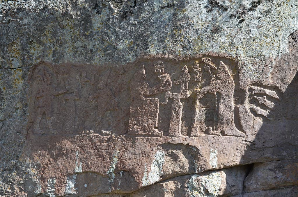
Carved into a riverside boulder in a Taurus mountain valley fifty kilometers south of Kayseri, the Fıraktın relief depicts Hittite Great King Hattusili III pouring water to the Weather God, while his queen Puduhepa makes a libation to the Sun Goddess. The scene may record the posthumous deification of the king. Mount Erciyes — itself a Hittite sacred mountain — is visible to the north. Four other Hittite reliefs were discovered within this same valley.
There are moments preserved in stone where the gap between past and present seems to close. The Fıraktın relief is one of them. On a boulder beside the Enzel Dere river, in a valley approaching the Taurus Mountains fifty kilometers south of Kayseri, two figures face each other across a ritual act. On the left, a tall male figure in a pointed hat pours water from a vessel to the Weather God Teshub. On the right, a female figure in a disc crown makes a libation to the Sun Goddess Hebat. The male figure is Hattusili III, Great King of the Hittite Empire — one of the most powerful rulers of the Bronze Age, co-signatory of the first recorded peace treaty in history, husband to one of the ancient world's most formidable queens. The female figure is Puduhepa, his wife and co-ruler, whose correspondence with Ramesses II of Egypt survives in the archives of two civilizations.
Both figures wear the pointed hats of divine status. This may record not a living ritual but its aftermath: Hattusili III is believed to have been deified after his death, under the reign of his son Tudhaliya IV. The relief may be a posthumous installation — the dead king and his queen carved performing the eternal act of cosmic maintenance at the threshold to the Taurus Mountains.
The valley around Fıraktın holds four other Hittite rock reliefs, making it the most concentrated site of Hittite sacred rock art in Anatolia. The location was not accidental: this valley commanded the ancient route into Cilicia through the Taurus, and Mount Erciyes — the great volcanic cone to the north, itself venerated as a Hittite mountain deity — watched over every carving made here.
Context and lineage
In the 13th century BCE, the Hittite Empire reached its greatest territorial extent and diplomatic influence. Hattusili III — who had seized the throne from his nephew Mursili III in a civil conflict — ruled from Hattusha (near modern Boğazkale) in central Anatolia. His queen, Puduhepa, was the daughter of a priest of the goddess Hebat and brought her own religious authority to the Great Kingship. Together they negotiated the Egyptian–Hittite peace treaty with Ramesses II (c. 1259 BCE), the oldest surviving international treaty, copies of which are held in both Hattusha and the Cairo Museum.
The Fıraktın relief was carved at some point during or after Hattusili III's reign (c. 1267–1237 BCE). The debated question is whether it was made during his lifetime — as a record of royal ritual — or posthumously, under his son and successor Tudhaliya IV, as part of the deification of the deceased king. The Hittite practice of royal deification after death would explain the divine pointed caps worn by both figures: they are not merely performing ritual, they are already in the realm of the divine.
The valley around Fıraktın holds four additional Hittite reliefs discovered between 1880 and 1939 (İmamkullu, Hanyeri, and the Taşçı group). The concentration suggests this valley was understood as a formally sacred zone — a corridor into the Taurus where the sacred geography of the Hittite Empire was most intensively inscribed.
The Fıraktın relief belongs to the Hittite tradition of royal libation scenes at sacred mountain passes — a practice concentrated in the Kayseri/Taurus region and documented at five sites in this single valley system. The combination of a king and a queen performing separate but parallel rituals is unusual; Puduhepa's prominence at Fıraktın reflects her documented religious authority in contemporary Hittite texts.
Hattusili III
Hittite Great King depicted on the left side of the relief, pouring water libation to the Weather God Teshub; one of the most prominent rulers of the Bronze Age, co-signatory of the Egyptian–Hittite peace treaty
Puduhepa
Hittite Great Queen (Tawannanna), depicted on the right side making a libation to the Sun Goddess Hebat; daughter of a priest of Hebat, considered a divine intermediary in her own right
Tudhaliya IV
Son and successor of Hattusili III; possibly the commissioner of the relief as part of his father's posthumous deification
Why this place is sacred
The Fıraktın valley's thinness is layered and geographical before it is symbolic. The valley is a corridor between worlds: lowland Anatolia to the north and the Taurus Mountains to the south, the Hittite heartland and the approaches to Cilicia, Syria, and the Mediterranean. Ancient movements of armies, merchants, and officials all passed through routes like this one. The relief was carved to consecrate the transition.
Hittite religion understood the libation — the pouring of water or wine to a god — as an act of cosmic maintenance. The king's ritual performance kept the divine order in proper relationship with the human world. Carved in stone at a mountain pass, that ritual became permanent: even after the king's death, the image of Hattusili III continues to pour water to Teshub at this valley's edge. The relief is not a record of something that happened once. It is the perpetuation of the act itself, frozen into the landscape.
The presence of Puduhepa in equal scale and prominence to the king is unusual in Hittite royal iconography. She was a priestess of Hebat before she became queen, and her religious authority was explicitly recognized in Hittite records. At Fıraktın, she faces the Sun Goddess directly — her role in the cosmic ritual equal to the king's. The valley holds this pairing in stone: two figures of equal divine standing, performing the ritual that maintained the world, beside a river, in sight of a sacred mountain.
To consecrate the mountain valley and the pass route into the Taurus, making the libation act permanent at a threshold between the Hittite heartland and the southern corridor to Cilicia; possibly also to establish Hattusili III's posthumous divine status through depiction in the canonical pose of ritual performance.
After the Hittite collapse (c. 1180 BCE), the valley's significance as an imperial route diminished. The relief remained visible beside the river, weathering slowly. In 1880 it was first recorded by modern scholars; four additional reliefs in the valley were discovered between 1880 and 1939. A plaster cast was made and sent to the Pergamonmuseum in Berlin; a concrete copy stands outside the Kayseri Museum. The original remains in situ beside the Enzel Dere.
Traditions and practice
In Hittite religion, the libation was an act of cosmic maintenance — the ritual pouring of water or wine to gods maintained the proper order between the divine and human worlds. At Fıraktın, the libation is carved permanently: the ritual does not need to be re-enacted because it has been made eternal in stone. The site was thus both the location of an original act and its permanent instantiation. The proximity to five Hittite reliefs in one valley suggests that this corridor was a formally recognized sacred zone, possibly visited by officials or clergy responsible for maintaining the mountain pass routes.
No active practices. The site receives visits from scholars, heritage tourists, and travelers following Hittite monument circuits. Occasionally included in specialist Hittite archaeological tours from Kayseri.
Walk to the site along the river. The approach on foot, following the sound of water through the valley, gives the encounter a different quality than arriving by vehicle. When you reach the carved boulder, stand before it and read the composition methodically: the king pouring water on the left, the queen with her vessel on the right, both in the pointed hats that mark divine status.
Ask the question the site invites: is this a record of something that happened, or a wish for something to be permanent? Hittite royal deification — the belief that a dead king continued to exist in divine form — makes both answers possible at once. The carving may show a living king performing ritual; or it may show a deified king performing ritual forever, installed in stone at the pass he once traveled.
Look north toward Mount Erciyes. Consider that the relief was placed in sight of that mountain deliberately — that the sacred geography of this valley was not accidental but designed, with multiple carvings distributed through the corridor in a pattern we can partly reconstruct but not fully understand. The five reliefs in this valley system were not the work of one moment but of a sustained Hittite investment in this particular landscape as sacred ground.
Hittite Royal and Divine Cult
HistoricalThe relief depicts the Hittite Great King Hattusili III and Great Queen Puduhepa performing libation rituals to the Weather God Teshub and Sun Goddess Hebat, possibly as a posthumous deification installation. The Fıraktın valley is the most concentrated site of Hittite rock sacred art in Anatolia.
Royal libation ritual to the storm god and sun goddess; the carving may have functioned as both commemoration of a living king's piety and perpetuation of the ritual act after his death.
Archaeological / Scholarly
ActiveThe site provides critical evidence for Hittite religious iconography, royal ideology, and the importance of the Taurus mountain passes for Hittite sacred geography. Casts held at Kayseri Museum and Pergamonmuseum Berlin.
Academic fieldwork, cast-making and museum display, inclusion in specialist Hittite monument tours.
Experience and perspectives
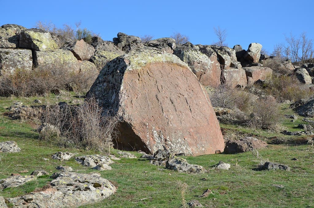
The Fıraktın relief sits at the end of a short walk along the Enzel Dere riverbank, reached by road from Develi to Fıraktın village and then on foot. The approach follows the sound of the river. The boulder on which the relief is carved sits directly on the bank, its carved face — roughly 3.2 meters wide by 1.3 meters high — at approximately eye level when approached from the front.
The composition reads left to right: Hattusili III tall and formal on the left, Teshub receiving the water libation at center-left, then space, then Puduhepa smaller but similarly crowned on the right, facing Hebat. Both royal figures wear the pointed divine cap. The detail in the carving — the vessel held by the king, the precise crown of the queen — is still legible despite three thousand years of weathering. Take time to read both sides of the scene separately before holding them together.
Then look north. Mount Erciyes, the great volcanic summit at 3,916 meters, is visible on a clear day. In Hittite religion, Erciyes was a mountain deity — one of thousands of mountain gods in the Hittite pantheon, but among the most prominent in the Kayseri region. The relief was placed where it was in part because this mountain was visible from it. The ritual scene faces a sacred mountain.
The river adds something that a museum cast cannot reproduce: the sound of moving water, the cool air of the bank, the fact that the carved figures have been beside this water since before the Hittite Empire fell. The libation the king pours to the Weather God was made partly in acknowledgment of water — of rain, of rivers, of the storm god's gift. The Enzel Dere is still here.
GPS: 38.2717°N, 35.6317°E. Located near Fıraktın village on the Enzel Dere river, east of Develi, approximately 50 km south of Kayseri city. Access by road to Fıraktın village followed by a short walk along the riverbank. A concrete cast of the relief is displayed outside the Archaeological Museum of Kayseri for those unable to reach the site.
The Fıraktın relief invites at least three distinct modes of encounter: the historical (who are these figures and what were they doing?), the theological (what does the libation scene mean in Hittite cosmology?), and the geographical (why here, in this valley, beside this river, facing this mountain?).
Scholarly consensus identifies the figures as Hattusili III and Puduhepa, the Hittite Great King and Queen of the 13th century BCE. The debate centers on the date of carving: whether it was made during Hattusili III's lifetime or posthumously under Tudhaliya IV as part of the program of royal deification. The Fıraktın area contains five Hittite reliefs discovered between 1880 and 1939, making it the most concentrated site of Hittite rock sacred art in Anatolia. The Kayseri Museum and the Pergamonmuseum both hold casts; the original is in situ.
No living tradition is directly associated with the site. The area remains inhabited by Turkish-speaking communities who are aware of the site's historical importance. No organized Hittite descendant community maintains it.
The river, the mountain, the carved libation: the sacred geography of Fıraktın is still readable in its natural features. The Enzel Dere flows as it did when the relief was carved; Mount Erciyes is still visible to the north. The site could be understood as a point where the vertical axis of the mountain (the sky, the storm god) meets the horizontal axis of the river valley (the route, the threshold) — a cosmogram embedded in the landscape itself. The royal libation is not simply a record of what happened but a map of how the Hittites understood their world to be structured.
Whether the carving was made during Hattusili III's lifetime or posthumously remains debated. The full religious program connecting the five reliefs in this valley has not been reconstructed. Whether this valley had a formal name as a sacred precinct in Hittite records is unknown.
Visit planning
Near Fıraktın village on the Enzel Dere, east of Develi, approximately 50 km south of Kayseri. GPS: 38.2717°N, 35.6317°E. The road to Fıraktın village is paved; the final approach is on foot along the riverbank. No formal visitor facilities at the site. A concrete copy of the relief is displayed outside the Archaeological Museum of Kayseri; a plaster cast is held at the Pergamonmuseum, Berlin.
Kayseri city (50 km north) offers a full range of accommodation. Develi has limited local options. No facilities near the site.
An open-air archaeological site beside a river; the carved surface and the natural setting both deserve care.
No specific requirements. Practical footwear for riverbank terrain.
Photography permitted. The northwest-facing relief surface is best captured in morning light or under diffuse overcast. The cast at the Kayseri Museum provides an alternative for documentation.
None appropriate. This is an archaeological site.
Do not touch the carved surface. Exercise caution on the riverbank. Do not remove any stones or material from the site.
Nearby sacred places
Sacred places within a half-day’s reach. Pilgrims often visit them together: walk one, stay for the other.

Taşçı Reliefs
Develi area, Kayseri, Central Anatolia Region, Turkey
15.4 km away
İmamkullu Relief
Tomarza area, Kayseri, Central Anatolia Region, Turkey
26.1 km away
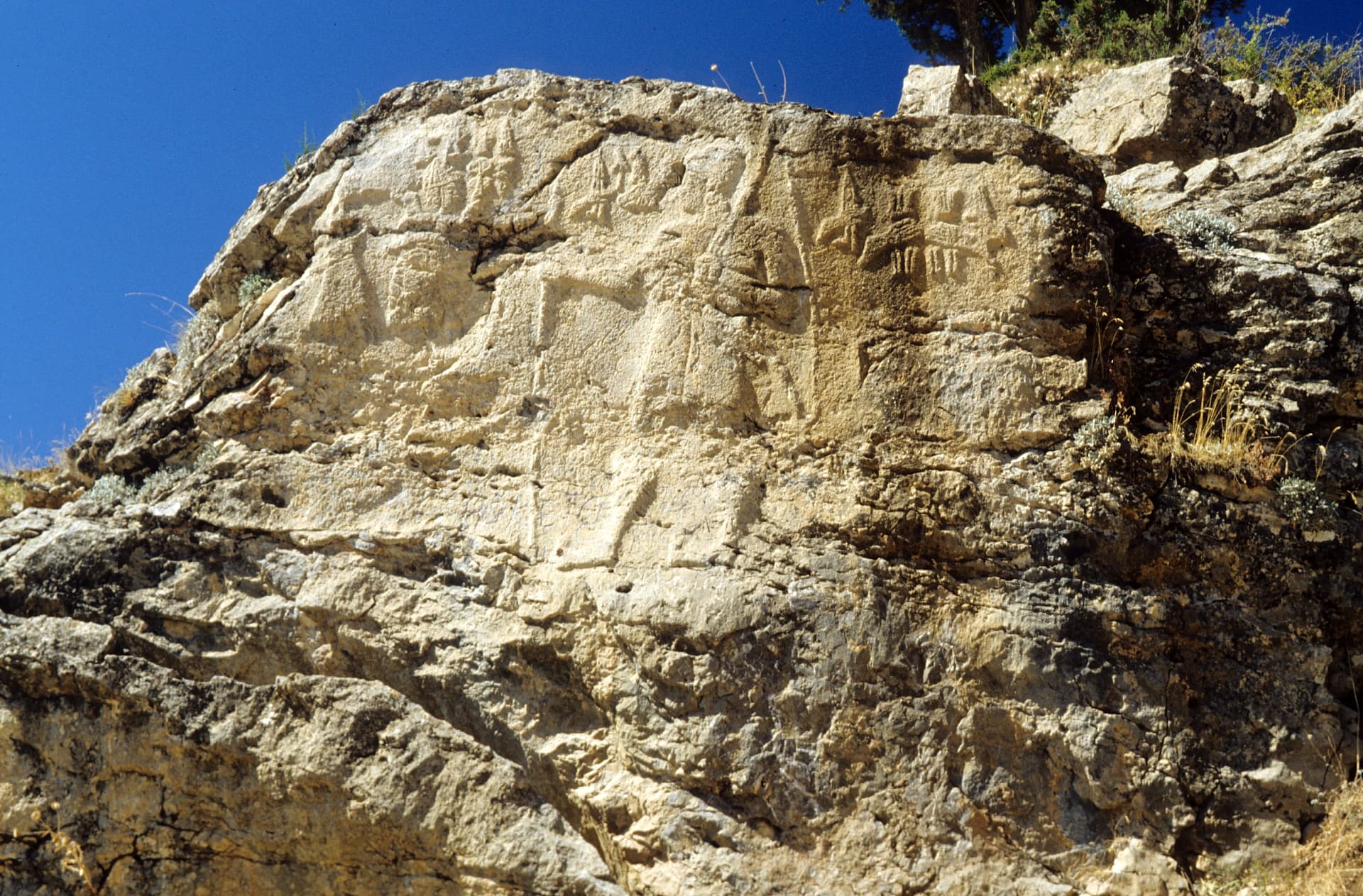
Hanyeri Relief
Tufanbeyli area, Adana, Mediterranean Region, Turkey
34.1 km away
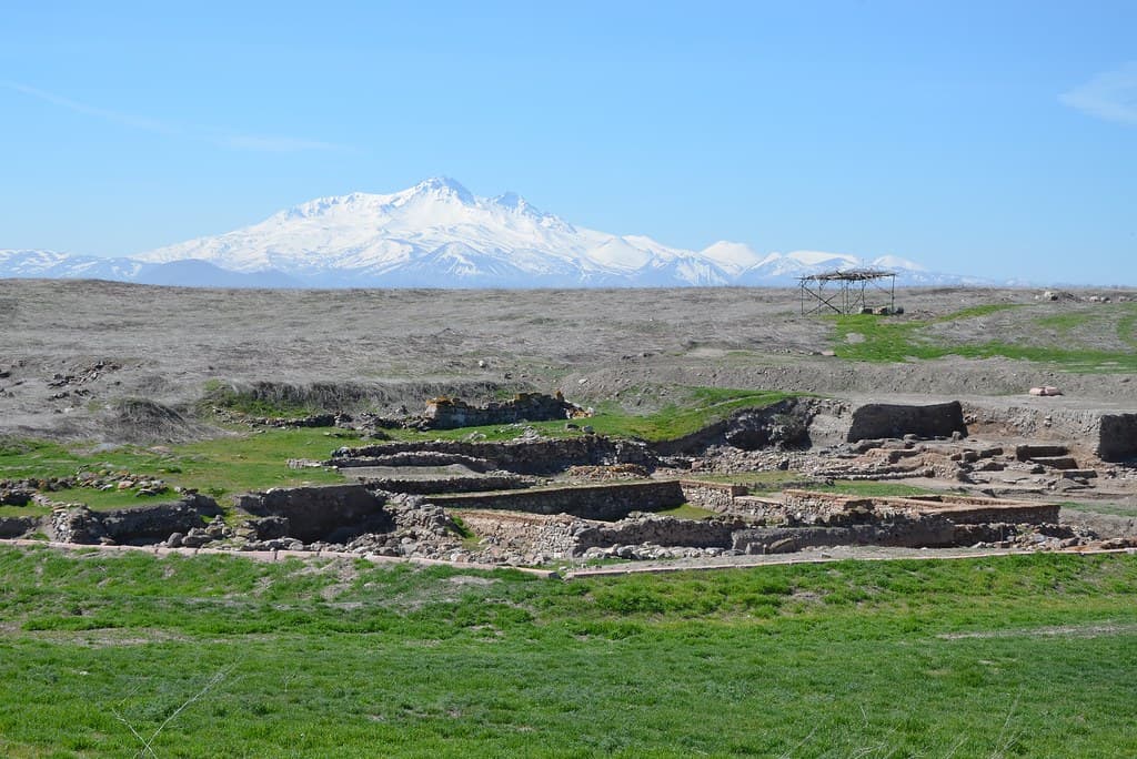
Kültepe-Kanesh
Kayseri, Kocasinan district, 20 km NE of Kayseri, Turkey
64.3 km away
References
Sources consulted when researching this page. Independent verification by readers is welcome.
- 01Hittite Monuments - Fraktin — Hittite Monuments Projecthigh-reliability
- 02Fraktin Hittite Rock Relief — World History Encyclopediahigh-reliability
- 03Fıraktın relief - Wikipedia — Wikipedia contributors
- 04Fraktin (Fıraktın) Relief - Vici.org — Vici.org contributors
- 05Kayseri - The Firaktin Hittite Rock Relief — Wow Cappadocia
- 06Fraktin Hittite Relief – Following Hadrian Photography — Following Hadrian
- 07About: Fıraktın relief — DBpedia
Key questions
What pilgrims usually ask
- Why is Fıraktın Relief considered sacred?
- The Fıraktın relief depicts Hittite Great King Hattusili III and Queen Puduhepa offering libations to their gods at a Taurus mountain valley near Kayseri, Turke
- What should I wear at Fıraktın Relief?
- No specific requirements. Practical footwear for riverbank terrain.
- Can I take photos at Fıraktın Relief?
- Photography permitted. The northwest-facing relief surface is best captured in morning light or under diffuse overcast. The cast at the Kayseri Museum provides an alternative for documentation.
- How long should I spend at Fıraktın Relief?
- 1–2 hours at the site; allow 1 hour each way from Kayseri or Develi.
- How do you visit Fıraktın Relief?
- Near Fıraktın village on the Enzel Dere, east of Develi, approximately 50 km south of Kayseri. GPS: 38.2717°N, 35.6317°E. The road to Fıraktın village is paved; the final approach is on foot along the riverbank. No formal visitor facilities at the site. A concrete copy of the relief is displayed outside the Archaeological Museum of Kayseri; a plaster cast is held at the Pergamonmuseum, Berlin.
- What offerings are appropriate at Fıraktın Relief?
- None appropriate. This is an archaeological site.
- What etiquette should visitors follow at Fıraktın Relief?
- An open-air archaeological site beside a river; the carved surface and the natural setting both deserve care.
- What is the history of Fıraktın Relief?
- In the 13th century BCE, the Hittite Empire reached its greatest territorial extent and diplomatic influence. Hattusili III — who had seized the throne from his nephew Mursili III in a civil conflict — ruled from Hattusha (near modern Boğazkale) in central Anatolia. His queen, Puduhepa, was the daughter of a priest of the goddess Hebat and brought her own religious authority to the Great Kingship. Together they negotiated the Egyptian–Hittite peace treaty with Ramesses II (c. 1259 BCE), the oldest surviving international treaty, copies of which are held in both Hattusha and the Cairo Museum. The Fıraktın relief was carved at some point during or after Hattusili III's reign (c. 1267–1237 BCE). The debated question is whether it was made during his lifetime — as a record of royal ritual — or posthumously, under his son and successor Tudhaliya IV, as part of the deification of the deceased king. The Hittite practice of royal deification after death would explain the divine pointed caps worn by both figures: they are not merely performing ritual, they are already in the realm of the divine. The valley around Fıraktın holds four additional Hittite reliefs discovered between 1880 and 1939 (İmamkullu, Hanyeri, and the Taşçı group). The concentration suggests this valley was understood as a formally sacred zone — a corridor into the Taurus where the sacred geography of the Hittite Empire was most intensively inscribed.