Harbetsuvan Tepesi
A Neolithic hilltop cult centre with sight lines to Göbekli Tepe — a node in a 10,000-year-old sacred landscape
Şanlıurfa, Southeastern Anatolia, Turkey

Plan this visit
Practical context before you go
A half-day visit, most productively combined with Karahantepe (7 km away) for a full day, and potentially with Göbekli Tepe on a separate day or extended itinerary.
53 km east of Şanlıurfa in the Tek Tek Mountains region. Accessible by private vehicle (GPS required) or guided tour from Şanlıurfa. Check the Taş Tepeler official programme (tastepeler.org or GoTürkiye) for current access arrangements and opening status, as visitor infrastructure was in development as of 2024–2025.
A managed heritage site within the Taş Tepeler programme; visit respectfully and stay on designated paths.
At a glance
- Coordinates
- 37.0487, 39.2525
- Type
- Neolithic Cult Centre
- Suggested duration
- A half-day visit, most productively combined with Karahantepe (7 km away) for a full day, and potentially with Göbekli Tepe on a separate day or extended itinerary.
- Access
- 53 km east of Şanlıurfa in the Tek Tek Mountains region. Accessible by private vehicle (GPS required) or guided tour from Şanlıurfa. Check the Taş Tepeler official programme (tastepeler.org or GoTürkiye) for current access arrangements and opening status, as visitor infrastructure was in development as of 2024–2025.
Pilgrim tips
- No religious dress code. Sturdy footwear for rocky hill terrain; sun protection is important on the exposed hilltop.
- Photography generally permitted; verify current restrictions with Taş Tepeler programme, particularly regarding sculptural finds.
- Verify access arrangements through the Taş Tepeler programme before visiting, as infrastructure was developing. The site is on a hilltop with exposed terrain; carry sun and wind protection. The access road requires a suitable vehicle.
Overview
Harbetsuvan Tepesi is a small-scale Pre-Pottery Neolithic B cult centre in the Tek Tek Mountains, 53 km east of Şanlıurfa, excavated 2017–2019. Positioned at 740 metres elevation on a hilltop with panoramic views of the Harran Plain, it was deliberately placed with intervisibility to both Göbekli Tepe (35 km northwest) and Karahantepe (7 km northeast), part of the Taş Tepeler sacred network that represents one of the world's oldest organised ritual landscapes.
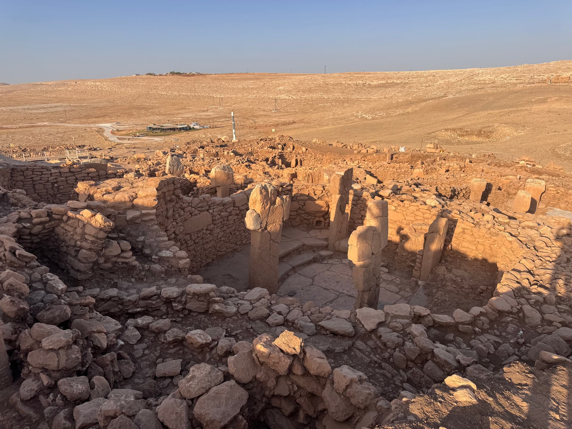
Harbetsuvan Tepesi does not announce itself with the scale of Göbekli Tepe or the accumulating discoveries of Karahantepe. It is a small site — 95 metres by 80 metres — on a hilltop at 740 metres elevation in the limestone terrain of the Tek Tek Mountains, known to archaeologists primarily through three seasons of excavation between 2017 and 2019. What makes it remarkable is not what was found within its buildings but where those buildings stand.
From Harbetsuvan's hilltop, both Göbekli Tepe and Karahantepe are visible. Göbekli Tepe lies 35 kilometres to the northwest; Karahantepe is 7 kilometres to the northeast. This intervisibility was almost certainly not accidental. The communities who built the Taş Tepeler network — whose sites cluster across the Şanlıurfa region in a pattern too consistent to be coincidental — appear to have selected their locations with deliberate attention to sight lines and mutual visibility. Harbetsuvan occupied a position in this network that allowed it to receive and return the gaze of the region's two largest known cult centres.
The buildings excavated here contained pairs of T-shaped stone pillars — the same symbolic form found at Göbekli Tepe and Karahantepe — and produced a seated male sculpture with phallic iconography paralleling those found at both larger sites. Finger reliefs on T-shaped pillars reinforce the interpretation that these pillars, across the Taş Tepeler landscape, represented anthropomorphic beings. Harbetsuvan was a smaller node in a network of shared sacred meaning: a place where the same cosmological language was spoken, the same figures were erected, the same kind of spatial separation from ordinary life was constructed — but at a scale appropriate to what may have been a satellite or seasonal gathering place rather than a primary ritual centre.
Context and lineage
Harbetsuvan Tepesi was identified in 2014 during a surface survey by Şanlıurfa Museum. No previous academic attention had been paid to the site, though its hilltop position with views across the Harran Plain had presumably made it visible throughout historical periods. Excavations in three seasons (2017–2019) under Bahattin Çelik of Iğdır University revealed rectangular buildings with paired T-shaped stone pillars, a seated male sculpture with phallic iconography, finger reliefs on pillars confirming anthropomorphic interpretation, and a material assemblage of flint and obsidian tools, ground stones, incised stone objects, and stone beads.
The seated male sculpture is particularly significant: it belongs to a category of finds now documented at multiple Taş Tepeler sites — Göbekli Tepe, Karahantepe, and Harbetsuvan — suggesting not isolated local invention but a shared iconographic tradition that used the same symbolic figure across the network of sites.
Harbetsuvan belongs to the Pre-Pottery Neolithic B cultural complex of the Şanlıurfa region, sharing building forms, pillar iconography, and sculpture types with Göbekli Tepe and Karahantepe. It is part of the Taş Tepeler ('Stone Hills') project, a Turkish Ministry of Culture initiative grouping approximately a dozen Neolithic sites in the Şanlıurfa region as a coherent heritage landscape.
Why this place is sacred
The concept of a sacred landscape — a network of sites whose meaning is constituted by their relationships with each other as much as by what happens within each individually — is often thought of as a feature of sophisticated, literate religious traditions. Harbetsuvan Tepesi pushes this concept back twelve thousand years.
The deliberate intervisibility between Harbetsuvan, Göbekli Tepe, and Karahantepe suggests that the Taş Tepeler communities understood their landscape theologically — as a territory whose sacred geography had been shaped by act as well as nature. Each hilltop cult centre was positioned to see and be seen by others. Whether this created a ritual network of seasonal visitation, a system of signal fires, a cosmological map expressed in geography, or something else entirely is not known. What is clear is that these sites were not isolated; they participated in each other's meaning.
The seated male sculpture found at Harbetsuvan — paralleling figures at Göbekli Tepe and Karahantepe — suggests the transmission not merely of building techniques but of iconography, cosmology, and symbolic vocabulary across the network. The same figures, the same T-shaped pillar form, the same architectural language: this is not convergence but communication, the evidence of a shared tradition maintained across a large geographical area over a significant span of time.
For contemporary visitors, standing on the Harbetsuvan hilltop with awareness of what lies in the landscape below — two of the world's oldest sanctuaries, visible on a clear day from where you stand — produces a particular quality of recognition: that the human impulse to organise the sacred landscape was already sophisticated, already relational, already thinking in networks, twelve thousand years ago.
A small-scale PPNB cult centre functioning as a node within the broader Taş Tepeler ritual landscape; probable site of communal gathering using rectangular buildings with T-shaped pillar pairs, sharing symbolic vocabulary with Göbekli Tepe and Karahantepe.
Active approximately 9000–8500 BCE. Excavated 2017–2019 by a Şanlıurfa Museum team under Bahattin Çelik. Now managed as part of the Taş Tepeler heritage tourism programme under the Turkish Ministry of Culture, positioned alongside Göbekli Tepe and Karahantepe as a destination for visitors exploring the broader Neolithic sacred landscape of southeastern Anatolia.
Traditions and practice
The rectangular buildings with paired T-shaped pillars at their centres were not domestic structures; their architecture, like that of the enclosures at Göbekli Tepe, was organised for gathering rather than habitation. The seated male sculpture with phallic iconography found within one of the buildings suggests ritual use involving symbolic or cosmological figures associated with generative or creative force. The finger reliefs on the T-shaped pillars, paralleling those found at other Taş Tepeler sites, indicate that the pillars were understood as anthropomorphic presences — beings that inhabited the building rather than merely structural elements. Communities may have gathered at Harbetsuvan seasonally, possibly in coordination with gatherings at Göbekli Tepe or Karahantepe, sharing a ritual calendar and cosmological framework across the landscape.
No active religious or spiritual practices occur at the site. It is managed as a heritage tourism destination within the Taş Tepeler programme.
Arrive at Harbetsuvan knowing where you are in the landscape. Before examining the excavated structures, orient yourself on the hilltop and locate Göbekli Tepe to the northwest and Karahantepe to the northeast. This geographical orientation is the primary interpretive key to the site — it tells you that you are not at an isolated ruin but at a node in a network, positioned by its builders with deliberate awareness of the sacred landscape they were constructing.
Then examine the building outlines. The T-shaped pillars no longer stand to their original height here, but their positions can be traced. Stand at the approximate centre of a building where a pillar pair would have stood and consider what it meant to enter a space with those figures present — not statues, not furniture, but presences that the builders understood as occupying the same interior as the living community gathered around them.
Finally, face the view. The Harran Plain, the limestone hills, the dry air of southeastern Anatolia in spring or autumn: this is the landscape that 10,000-year-old communities organised their sacred life within. It has changed less than almost any other feature of the scene.
Pre-Pottery Neolithic B cultic tradition (Taş Tepeler regional complex)
HistoricalHarbetsuvan Tepesi functioned as a small-scale PPNB cultic node within the Taş Tepeler ritual landscape, sharing architectural forms, iconographic vocabulary, and likely cosmological frameworks with Göbekli Tepe and Karahantepe. Its deliberate placement with intervisibility to both larger centres suggests it was positioned as part of a geographically organised sacred system.
Construction of rectangular buildings with paired central T-shaped pillars; probable ritual use of a seated male sculpture with phallic iconography; use of flint, obsidian, and ground stone tools; stone beads as personal ornament. Communal gathering in pillar-pair buildings following the same spatial logic as the larger enclosures at Göbekli Tepe.
Experience and perspectives
The approach to Harbetsuvan Tepesi begins with the landscape itself. The Tek Tek Mountains in southeastern Anatolia are not dramatic in the way of high alpine terrain, but they have a quality of exposure — dry limestone hills with long views, sparse vegetation, the sense of a terrain that has not been substantially altered by anything that happened after the Neolithic. The road from Şanlıurfa passes through agricultural land and small villages before the track toward the site begins to climb.
At 740 metres, the hilltop opens onto a panorama that justified this particular position to whoever chose it. On a clear day, the Harran Plain spreads west and south, with Göbekli Tepe's characteristic ridge discernible to the northwest. Karahantepe is closer, 7 kilometres northeast, its own hilltop visible. To stand here and know this — to understand that you are at a site placed with conscious awareness of those two others — transforms the experience from a visit to an isolated ruin into something more like reading a text whose words are spread across the landscape.
The excavated area is modest: rectangular buildings, the positions of T-shaped pillar pairs, the ghost-footprint of a Neolithic cult space reduced to its lowest courses of stone. The site does not have the preserved height of Göbekli Tepe's enclosures. What it has is position. Spend time on the hilltop edge, facing northwest toward where Göbekli Tepe lies, and then turn to the northeast toward Karahantepe. Let the geometry of the sacred landscape register. The builders of this site knew that geometry too.
Harbetsuvan Tepesi is located 53 km east of Şanlıurfa, within the Tek Tek Mountains region, reachable by private vehicle or guided tour from Şanlıurfa. The site is part of the official Taş Tepeler tourism programme; access arrangements and current opening status should be verified through the GoTürkiye Taş Tepeler programme before visiting. As of 2024–2025, visitor infrastructure was in development. The site is best combined with Karahantepe (7 km distant) as a single day visit, with Göbekli Tepe as a separate day or combined with an early start.
Harbetsuvan Tepesi is best understood not in isolation but within the interpretive frame of the Taş Tepeler landscape, where its position and finds gain their full significance.
The scholarly characterisation of Harbetsuvan as a 'small-scale cult centre' (Çelik's designation) reflects both its modest physical size and its clear participation in the symbolic vocabulary of the larger Taş Tepeler sites. The intervisibility network between Taş Tepeler sites is emerging as a significant research area — the deliberate placement of cult centres with sight lines to each other suggests a spatially organised ritual system that predates any other comparable landscape of sacred geography. Harbetsuvan's contribution to this interpretation is primarily positional: its location confirms the network's deliberate logic.
No living indigenous tradition is directly associated with Harbetsuvan Tepesi. The broader Turkish and Kurdish communities of the Şanlıurfa region recognise the Taş Tepeler sites collectively as a heritage landscape of global importance.
The phallic sculpture and male figurative iconography at multiple Taş Tepeler sites have attracted interpretations involving fertility cults, male creator deities, or a gendered cosmological dualism (male creative force, female earth). Mainstream archaeology regards the iconography as evidence of anthropomorphic cosmological belief systems without assigning specific theological content.
What was the specific functional relationship between Harbetsuvan and the larger centres at Göbekli Tepe and Karahantepe? Did communities travel between them seasonally? What specific rituals occurred in the central-pillar rooms? Why was intervisibility — the ability to see and be seen from other cult centres — apparently a criterion for site selection across the Taş Tepeler network?
Visit planning
53 km east of Şanlıurfa in the Tek Tek Mountains region. Accessible by private vehicle (GPS required) or guided tour from Şanlıurfa. Check the Taş Tepeler official programme (tastepeler.org or GoTürkiye) for current access arrangements and opening status, as visitor infrastructure was in development as of 2024–2025.
Şanlıurfa is the base for all Taş Tepeler sites. The old city offers atmospheric accommodation near the Balıklıgöl (Pool of Sacred Fish). Budget 2–3 nights to visit the major sites in the network without rushing.
A managed heritage site within the Taş Tepeler programme; visit respectfully and stay on designated paths.
No religious dress code. Sturdy footwear for rocky hill terrain; sun protection is important on the exposed hilltop.
Photography generally permitted; verify current restrictions with Taş Tepeler programme, particularly regarding sculptural finds.
Not applicable at this archaeological site.
Stay on designated paths. Do not touch architectural remains, sculptural elements, or pillar positions. Respect any excavation zone boundaries.
Nearby sacred places
Sacred places within a half-day’s reach. Pilgrims often visit them together: walk one, stay for the other.


References
Sources consulted when researching this page. Independent verification by readers is welcome.
- 01Harbetsuvan – Taş Tepeler Official Project — Taş Tepeler Projecthigh-reliability
- 02A small-scale cult centre in Southeast Turkey: Harbetsuvan Tepesi — Bahattin Çelikhigh-reliability
- 03A New Cult Centre: Harbetsuvan Tepesi — Bahattin Çelikhigh-reliability
- 04Excavation Study of Harbetsuvan Tepesi in 2018 — Karadeniz International Scientific Journalhigh-reliability
- 05Harbetsuvan Tepe: The 10,000-Year-Old Neolithic Acropolis of Taş Tepeler — Arkeonews
- 06Harbetsuvan Archaeological Site Guide – Go Türkiye — GoTürkiye (Turkish Tourism Promotion Board)
- 07Harbetsuvan Tepesi Ancient Village or Settlement – The Megalithic Portal — Megalithic Portal
Key questions
What pilgrims usually ask
- Why is Harbetsuvan Tepesi considered sacred?
- Harbetsuvan Tepesi is a 10,000-year-old Neolithic hilltop cult centre in southeastern Turkey, intervisible with Göbekli Tepe and Karahantepe.
- What should I wear at Harbetsuvan Tepesi?
- No religious dress code. Sturdy footwear for rocky hill terrain; sun protection is important on the exposed hilltop.
- Can I take photos at Harbetsuvan Tepesi?
- Photography generally permitted; verify current restrictions with Taş Tepeler programme, particularly regarding sculptural finds.
- How long should I spend at Harbetsuvan Tepesi?
- A half-day visit, most productively combined with Karahantepe (7 km away) for a full day, and potentially with Göbekli Tepe on a separate day or extended itinerary.
- How do you visit Harbetsuvan Tepesi?
- 53 km east of Şanlıurfa in the Tek Tek Mountains region. Accessible by private vehicle (GPS required) or guided tour from Şanlıurfa. Check the Taş Tepeler official programme (tastepeler.org or GoTürkiye) for current access arrangements and opening status, as visitor infrastructure was in development as of 2024–2025.
- What offerings are appropriate at Harbetsuvan Tepesi?
- Not applicable at this archaeological site.
- What etiquette should visitors follow at Harbetsuvan Tepesi?
- A managed heritage site within the Taş Tepeler programme; visit respectfully and stay on designated paths.
- What is the history of Harbetsuvan Tepesi?
- Harbetsuvan Tepesi was identified in 2014 during a surface survey by Şanlıurfa Museum. No previous academic attention had been paid to the site, though its hilltop position with views across the Harran Plain had presumably made it visible throughout historical periods. Excavations in three seasons (2017–2019) under Bahattin Çelik of Iğdır University revealed rectangular buildings with paired T-shaped stone pillars, a seated male sculpture with phallic iconography, finger reliefs on pillars confirming anthropomorphic interpretation, and a material assemblage of flint and obsidian tools, ground stones, incised stone objects, and stone beads. The seated male sculpture is particularly significant: it belongs to a category of finds now documented at multiple Taş Tepeler sites — Göbekli Tepe, Karahantepe, and Harbetsuvan — suggesting not isolated local invention but a shared iconographic tradition that used the same symbolic figure across the network of sites.