Ute Mountain, New Mexico
A dormant volcanic deity rising above the Taos Plateau in silence and wind
Taos County, New Mexico, United States

Plan this visit
Practical context before you go
The round-trip hike takes 6 to 8 hours for experienced cross-country hikers. Allow a full day to include time for contemplation at the summit. Multi-day backpacking trips are possible within the wilderness area for those seeking extended immersion.
From the traffic light in Questa, New Mexico, drive 9.7 miles north on Highway 522 to the signed Sunshine Valley Road. Access to the mountain's base is via this road heading east or west. There is no established trailhead, no marked trail, and no designated parking. Limited informal pulloffs along Sunshine Valley Road serve as starting points. No entrance fee is charged for the national monument. The Rio Grande del Norte Visitor Center in Questa provides maps and current conditions. Mobile phone signal is unreliable on the plateau and should not be relied upon for navigation or emergency communication. The nearest settlement with reliable service is Questa.
Ute Mountain asks for the respect due both to a wilderness ecosystem and to a site of indigenous cultural significance. The absence of infrastructure is intentional. Leave no trace, disturb nothing, and approach with the awareness that this mountain carries meaning beyond recreation.
At a glance
- Coordinates
- 36.9375, -105.6839
- Suggested duration
- The round-trip hike takes 6 to 8 hours for experienced cross-country hikers. Allow a full day to include time for contemplation at the summit. Multi-day backpacking trips are possible within the wilderness area for those seeking extended immersion.
- Access
- From the traffic light in Questa, New Mexico, drive 9.7 miles north on Highway 522 to the signed Sunshine Valley Road. Access to the mountain's base is via this road heading east or west. There is no established trailhead, no marked trail, and no designated parking. Limited informal pulloffs along Sunshine Valley Road serve as starting points. No entrance fee is charged for the national monument. The Rio Grande del Norte Visitor Center in Questa provides maps and current conditions. Mobile phone signal is unreliable on the plateau and should not be relied upon for navigation or emergency communication. The nearest settlement with reliable service is Questa.
Pilgrim tips
- Sturdy hiking boots with ankle support are essential for the trailless volcanic terrain. Long pants protect against prickly vegetation on the lower slopes. Layers are critical, as temperatures can vary dramatically between the sun-exposed plateau and the shaded summit forest, and weather changes rapidly at altitude. Sun protection is vital on the exposed approach across the open plateau.
- Photography is permitted throughout the national monument and wilderness area. If any ceremonial objects or cultural offerings are encountered, do not photograph, touch, or disturb them.
- This is not a site where spiritual practice should override physical safety. The mountain has no trails, no shelter, and no reliable water sources. Summer thunderstorms can arrive with little warning, and the exposed summit is dangerous during lightning. Turn back if conditions deteriorate. Any ceremonial objects or offerings encountered on or near the mountain should not be touched, photographed, or disturbed.
Overview
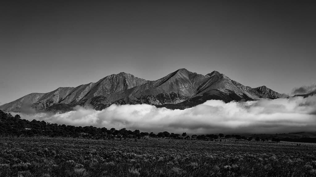
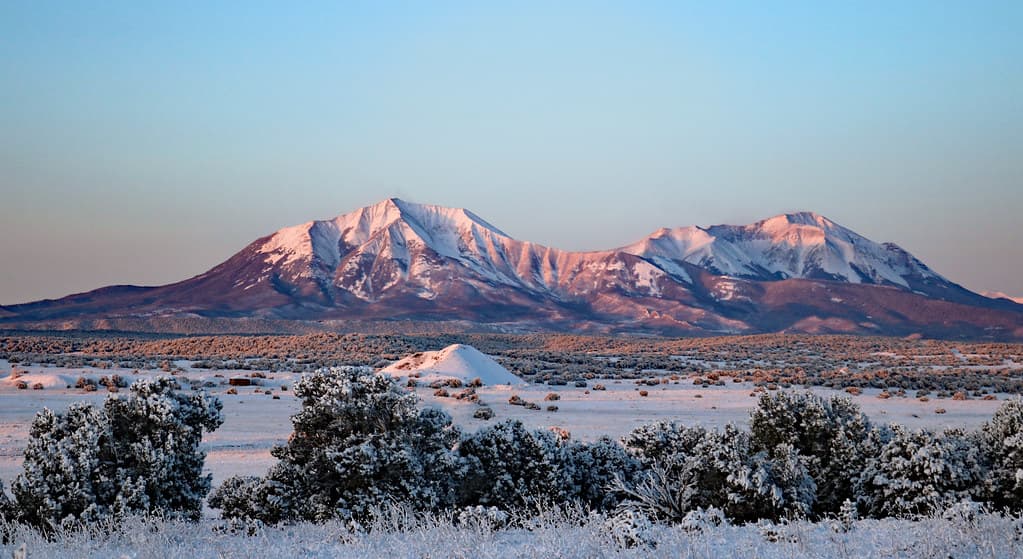
Ute Mountain is a solitary volcanic cone rising nearly 2,500 feet above the sagebrush plains of northern New Mexico. Named for the Ute people who regarded it as a place of peace and a sleeping deity, it stands as the highest point within the Rio Grande del Norte National Monument. No trails lead to its summit. Those who reach it find a silence so complete it becomes a presence of its own.
Something watches from the Taos Plateau. Rising sharply from miles of flat sage-covered basalt, Ute Mountain commands the landscape not through grandeur alone but through isolation. There are no trails, no signs, no other hikers. The mountain simply stands, as it has for millions of years, indifferent to whether anyone comes.
The Ute people, whose ancestral territory encompassed this region, did not see indifference. They understood the mountain as a deity who had collected rain clouds in anger, holding storms in its pockets. When weather breaks across the plateau, the old story comes alive. They held further that the mountain would one day awaken to fight their enemies, imbuing the peak with dormant protective power.
That power has not faded, even as the Ute homelands contracted and modern boundaries displaced them. The mountain received federal protection in 2013 as part of the Rio Grande del Norte National Monument, and in 2019 earned wilderness designation as the Cerro del Yuta Wilderness, its Spanish name echoing the people for whom it was named. The protections recognize what the Ute have long known: this mountain matters, and the emptiness around it is not absence but fullness waiting to be noticed.
Context and lineage
In Ute understanding, the mountain is not passive geology but an animate being. The deity who became Ute Mountain collected rain clouds in anger, holding them in pockets. When storms break across the plateau, they arise from clouds that have escaped. The belief that the mountain will one day awaken to fight the enemies of the Ute speaks to a relationship not with landscape but with kin, a protector resting but not gone.
Ute creation narratives, as maintained by elders like Alden Naranjo of the Southern Ute, hold that the Ute have always occupied this mountainous region, in contrast to migration stories told by other peoples. The mountain stands as witness to that continuity.
The mountain's human story follows a pattern common to indigenous sacred sites in the American West. Centuries of Ute presence gave way to colonial displacement, as the tribe was moved to reservations far from their ancestral lands. The mountain persisted without its people, unnamed on early American maps, largely ignored by settlers focused on the valleys below. The 21st century brought renewed recognition: the Rio Grande del Norte National Monument in 2013, the Cerro del Yuta Wilderness in 2019. The Spanish name Cerro del Yuta preserves the Ute connection in the language of the colonizers who displaced them.
Alden Naranjo
elder
Southern Ute elder who maintains that Ute creation narratives hold the people have always occupied this mountainous region of the Southwest, anchoring the mountain within a story of permanence rather than migration.
The Muache Band
historical community
The Ute band most closely associated with northern New Mexico. Sometimes called the Taos-Ute for their trading relationships with Taos Pueblo, they frequented the lands around Ute Mountain for centuries before displacement to reservations in Colorado.
U.S. Senator Martin Heinrich
conservator
Championed the 2019 Cerro del Yuta Wilderness designation that gave Ute Mountain the highest level of federal land protection, explicitly recognizing the mountain's cultural and ecological significance.
Why this place is sacred
The plateau stretches for miles in every direction, covered in sage and volcanic basalt. Then the mountain appears. Not gradually, the way ranges build, but suddenly, a single cone rising 2,500 feet from the flat earth. The visual shock is part of what makes this place feel thin. The mountain should not be here, and yet it is, rooted in geological forces that shaped the largest volcanic field in the Rio Grande Rift.
Isolation intensifies the effect. No trails mark the route. No infrastructure softens the approach. The only sounds are wind through sage and, in season, the distant bugle of elk. This is not curated wilderness but the real thing, and the body registers the difference. Hours of cross-country hiking through increasingly varied terrain, from sagebrush flats through pinon-juniper woodland to spruce and fir near the summit, create a gradual shedding of ordinary preoccupations.
The Ute understood this mountain as a boundary marker between their territory and Pueblo lands to the south. Liminal places, places between, have carried spiritual significance across cultures. The mountain sits at exactly such a threshold, geological and cultural, and something of that betweenness persists for those who make the effort to reach it.
Ute tradition held Ute Mountain as a place of peace. The specific ceremonial practices conducted here belong to the sacred-private realm of Ute spiritual life and are not fully documented in available sources. What is clear is that the mountain was not merely a landmark but a living entity within Ute cosmology, a deity with agency and intention.
The Muache Band of Utes, sometimes called the Taos-Ute for their trading relationships with Taos Pueblo, frequented this region for centuries. As colonial pressures forced the Ute westward to reservations in Colorado and Utah, the mountain lost its human community but not its presence. Federal designation in the 21st century has brought new forms of protection, though the wilderness remains so remote that most visitors to the national monument never approach it.
Traditions and practice
Ute tradition held the mountain as a place of peace. The specific ceremonies or practices conducted here remain within the sacred-private realm of Ute spiritual life, and publicly available sources do not detail them. This silence around specifics may itself be significant, reflecting the Ute understanding that some knowledge belongs to the people and the land, not to documentation.
The mountain does not host organized spiritual programs, guided meditations, or retreat groups. Its remoteness and lack of trails ensure that those who visit do so on their own terms. Individual visitors may bring personal contemplative practices to the summit, though the mountain asks nothing in particular and offers nothing structured in return.
Begin with the approach itself. The hours of cross-country hiking across the open plateau are not preamble but practice. Notice how your attention narrows to the immediate, to footing and direction and the mountain growing slowly larger. The sage releases scent as you brush through it. The wind carries sounds from distances you cannot usually perceive.
On the upper slopes, as the vegetation changes from desert to montane forest, pause where the views open. The plateau below looks different from above, its vastness apparent only with altitude. At the summit, if conditions allow, sit with the silence. This is not the silence of a quiet room but the silence of a landscape where human sound has never been dominant.
If afternoon clouds begin to build around the peak, consider the Ute story. The clouds escaping the mountain's pockets. The storms that follow. What does it mean to stand on a being that holds weather in its hands?
Ute (Nuuchi-u)
HistoricalThe mountain is named for the Ute people, whose ancestral territory encompassed vast areas of present-day Colorado, Utah, Wyoming, and northern New Mexico. Ute tradition holds the mountain as a place of peace and understands it as a deity who collected rain clouds in anger. The Muache Band of Utes maintained close trading relationships with Taos Pueblo and frequented this region for centuries before forced removal to reservations.
The mountain was regarded as a place of peace within the broader Ute sacred landscape. Specific ceremonial practices at this particular peak are not documented in publicly available sources, which may reflect the sacred-private nature of Ute spiritual tradition rather than an absence of practice.
Pueblo (Taos Pueblo and neighboring pueblos)
HistoricalWhile direct sources documenting Taos Pueblo's specific relationship to Ute Mountain are limited, the mountain lies within sight of one of the oldest continuously inhabited communities in the Americas. The Muache Ute traded extensively with Taos Pueblo, and the two peoples' sacred landscapes almost certainly overlapped in this region.
Conservation stewardship
ActiveThe 2013 designation of the Rio Grande del Norte National Monument and the 2019 Cerro del Yuta Wilderness designation represent a modern form of honoring this landscape. The wilderness protections explicitly recognize both ecological and cultural values, ensuring the mountain's isolation and wildness persist.
The Bureau of Land Management manages the national monument and wilderness area. The Trust for Public Land has documented the mountain's cultural significance and contributed to stewardship efforts. Ongoing management focuses on maintaining the wilderness character that makes the site exceptional.
Experience and perspectives
The approach takes hours and offers no shortcuts. From wherever you leave your vehicle along Sunshine Valley Road, the mountain draws you across open sage flats where the only navigation is the peak itself. The terrain changes underfoot, from basalt rubble to soft soil to increasingly steep volcanic slopes where loose rock demands attention.
Visitors report that the physical challenge reshapes attention. The demanding cross-country travel, 2,400 feet of elevation gain without trail or cairn, requires the kind of sustained bodily focus that clears the mind of its usual chatter. By the time you reach the upper slopes, where spruce and fir replace the lower pinon-juniper, something has shifted. The effort itself becomes a form of practice.
The summit rewards with 360-degree views across the entire Taos Plateau, into Colorado to the north, and toward the Sangre de Cristo Mountains to the east. On clear days, the sense of being the only human presence for miles in every direction is not loneliness but liberation. Weather moves visibly across the plateau, clouds building and dissolving over the volcanic terrain, and when thunderstorms gather in the afternoon, as they often do in summer, the Ute story of clouds escaping the mountain's pockets ceases to feel like metaphor.
This mountain asks for physical preparation and navigational confidence. Bring detailed maps, ample water, and layers for rapidly changing conditions. Start at dawn to allow time for the round trip and to descend before afternoon thunderstorms. Let the approach be the beginning of your practice, not an obstacle to it. The absence of a trail is not a deficiency but an invitation to move through the landscape on its own terms.
Ute Mountain sits at the intersection of geological science, indigenous cosmology, and the contemporary search for genuine wilderness experience. Each perspective illuminates something the others miss, and the mountain is large enough to hold them all without contradiction.
Geologists identify Ute Mountain as an extinct dacitic volcanic cone formed during the Pliocene epoch, roughly 2 to 5 million years ago. It is the highest point within the Taos Plateau volcanic field, the largest volcanic field in the Rio Grande Rift, covering approximately 7,000 square kilometers. The USGS has produced detailed geological mapping of the mountain and its surroundings. Historically, the mountain is understood as a landmark within the ancestral territory of the Ute people, particularly the Muache Band who maintained trade networks with neighboring Pueblo communities centered at Taos.
Ute tradition understands the mountain as a living entity. The deity who became Ute Mountain collected rain clouds in anger, and storms arise when those clouds escape. The mountain will one day awaken to fight the enemies of the Ute, a narrative that positions the peak not as passive landscape but as dormant protector. For the Ute, this is not metaphor. The creation narratives maintained by elders hold that the Ute have always occupied this mountainous region, and the mountain stands as evidence of that enduring presence.
The mountain has not attracted the New Age attention directed at more accessible sacred sites in northern New Mexico, largely because reaching it requires genuine wilderness skills and sustained physical effort. Those who do visit for spiritual reasons tend to be drawn by the solitude itself rather than by esoteric frameworks. The volcanic geology of the site, combined with its isolation, appeals to seekers interested in earth-based spirituality and those who find contemplative value in landscapes shaped by deep geological forces.
Several genuine mysteries surround this mountain. The specific ceremonial practices the Ute historically conducted here, as distinct from other mountains in their territory, are not documented in publicly available sources. Whether Pueblo peoples, particularly Taos Pueblo located 35 miles south, maintain their own traditional relationship with this peak remains unclear. The full archaeological record of human activity on and around the mountain has not been systematically surveyed. Whether the volcanic geology played a specific role in the mountain's sacred significance, as it has at volcanic sacred sites in other cultures worldwide, is a question the available research cannot answer.
Visit planning
From the traffic light in Questa, New Mexico, drive 9.7 miles north on Highway 522 to the signed Sunshine Valley Road. Access to the mountain's base is via this road heading east or west. There is no established trailhead, no marked trail, and no designated parking. Limited informal pulloffs along Sunshine Valley Road serve as starting points. No entrance fee is charged for the national monument. The Rio Grande del Norte Visitor Center in Questa provides maps and current conditions. Mobile phone signal is unreliable on the plateau and should not be relied upon for navigation or emergency communication. The nearest settlement with reliable service is Questa.
No accommodations exist near the mountain. Questa, approximately 15 miles south on Highway 522, offers basic lodging and services. Taos, 35 miles south, provides a full range of accommodations. Wild Rivers Recreation Area, within the national monument to the west, has developed campgrounds with basic facilities. Dispersed camping is permitted within the wilderness area following Leave No Trace principles and BLM regulations.
Ute Mountain asks for the respect due both to a wilderness ecosystem and to a site of indigenous cultural significance. The absence of infrastructure is intentional. Leave no trace, disturb nothing, and approach with the awareness that this mountain carries meaning beyond recreation.
Sturdy hiking boots with ankle support are essential for the trailless volcanic terrain. Long pants protect against prickly vegetation on the lower slopes. Layers are critical, as temperatures can vary dramatically between the sun-exposed plateau and the shaded summit forest, and weather changes rapidly at altitude. Sun protection is vital on the exposed approach across the open plateau.
Photography is permitted throughout the national monument and wilderness area. If any ceremonial objects or cultural offerings are encountered, do not photograph, touch, or disturb them.
Wilderness regulations prohibit motorized vehicles and mechanical transport. Pack out all trash. Camp at least 300 feet from water sources. Campfires may be restricted depending on fire conditions. Check with the BLM Taos Field Office for current regulations before your visit.
Plan your visit
Address
Ute Mountain, New Mexico 87524, USA
Hours, fees, and access can change — verify on the official source before you travel. Practical details last checked Jun 2026.
Nearby sacred places
Sacred places within a half-day’s reach. Pilgrims often visit them together: walk one, stay for the other.

Key questions
What pilgrims usually ask
- Why is Ute Mountain, New Mexico considered sacred?
- Stand atop a volcanic cone revered by the Ute people as a sleeping deity. Trailless wilderness hiking in New Mexico's Rio Grande del Norte.
- What should I wear at Ute Mountain, New Mexico?
- Sturdy hiking boots with ankle support are essential for the trailless volcanic terrain. Long pants protect against prickly vegetation on the lower slopes. Layers are critical, as temperatures can vary dramatically between the sun-exposed plateau and the shaded summit forest, and weather changes rapidly at altitude. Sun protection is vital on the exposed approach across the open plateau.
- Can I take photos at Ute Mountain, New Mexico?
- Photography is permitted throughout the national monument and wilderness area. If any ceremonial objects or cultural offerings are encountered, do not photograph, touch, or disturb them.
- How long should I spend at Ute Mountain, New Mexico?
- The round-trip hike takes 6 to 8 hours for experienced cross-country hikers. Allow a full day to include time for contemplation at the summit. Multi-day backpacking trips are possible within the wilderness area for those seeking extended immersion.
- How do you visit Ute Mountain, New Mexico?
- From the traffic light in Questa, New Mexico, drive 9.7 miles north on Highway 522 to the signed Sunshine Valley Road. Access to the mountain's base is via this road heading east or west. There is no established trailhead, no marked trail, and no designated parking. Limited informal pulloffs along Sunshine Valley Road serve as starting points. No entrance fee is charged for the national monument. The Rio Grande del Norte Visitor Center in Questa provides maps and current conditions. Mobile phone signal is unreliable on the plateau and should not be relied upon for navigation or emergency communication. The nearest settlement with reliable service is Questa.
- What etiquette should visitors follow at Ute Mountain, New Mexico?
- Ute Mountain asks for the respect due both to a wilderness ecosystem and to a site of indigenous cultural significance. The absence of infrastructure is intentional. Leave no trace, disturb nothing, and approach with the awareness that this mountain carries meaning beyond recreation.
- What is the history of Ute Mountain, New Mexico?
- In Ute understanding, the mountain is not passive geology but an animate being. The deity who became Ute Mountain collected rain clouds in anger, holding them in pockets. When storms break across the plateau, they arise from clouds that have escaped. The belief that the mountain will one day awaken to fight the enemies of the Ute speaks to a relationship not with landscape but with kin, a protector resting but not gone. Ute creation narratives, as maintained by elders like Alden Naranjo of the Southern Ute, hold that the Ute have always occupied this mountainous region, in contrast to migration stories told by other peoples. The mountain stands as witness to that continuity.
- Who is associated with Ute Mountain, New Mexico?
- Alden Naranjo (elder), The Muache Band (historical community), U.S. Senator Martin Heinrich (conservator)