Upper Borgue Broch
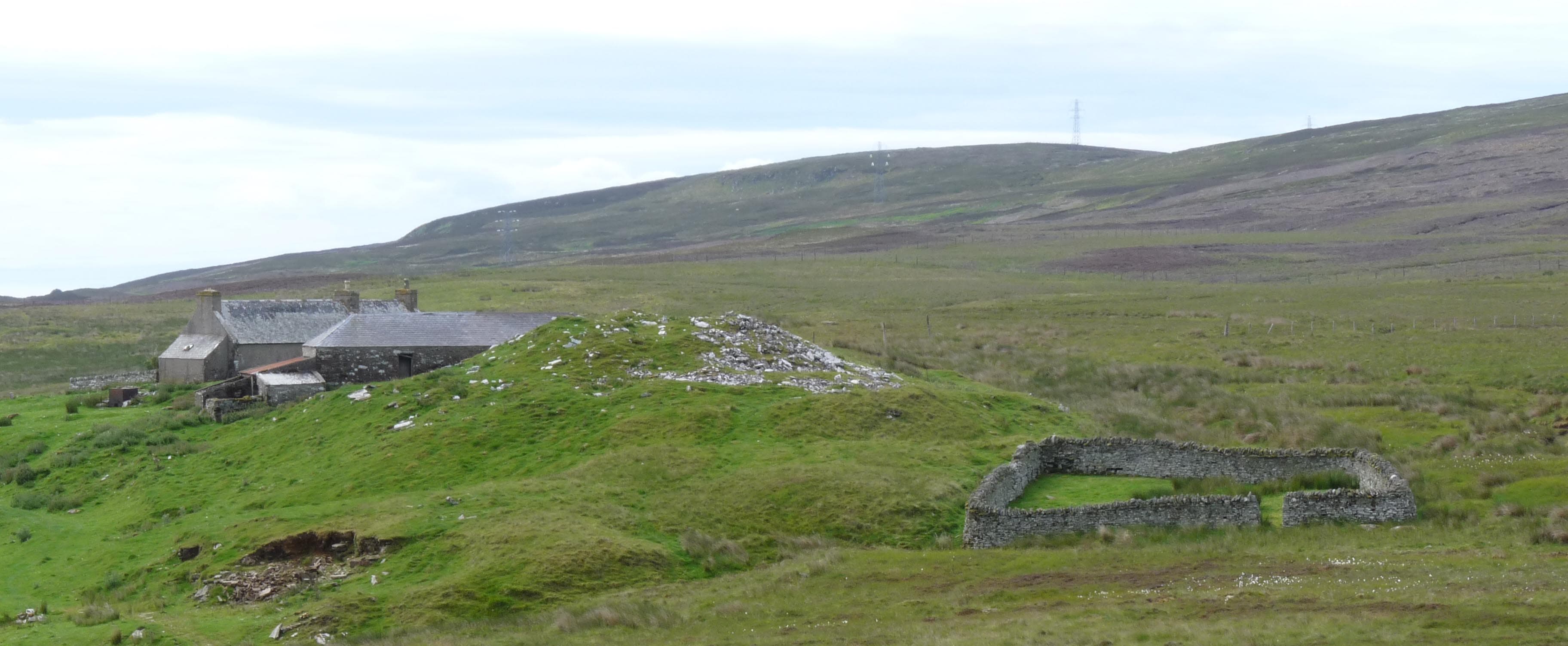
A vegetation-covered Iron Age mound behind a Caithness farm, part of the dense prehistoric landscape of the Dunbeath hinterland
Dunbeath, Caithness, United Kingdom
Plan this visit
Practical context before you go
Thirty minutes including landscape survey from the mound.
Located behind the farm of Upper Borgue, off minor roads south of Dunbeath village on the A9. No formal parking or signage. Private agricultural land; seek landowner permission. Not wheelchair accessible. Nearest public transport: A9 bus stops at Dunbeath. Nearest railway: Helmsdale, approximately 13 miles south.
Upper Borgue Broch is on private agricultural land. Visiting requires courtesy toward the landowner, respect for the monument, and practical preparation for rural Caithness conditions.
At a glance
- Coordinates
- 58.2366, -3.5070
- Type
- Broch
- Suggested duration
- Thirty minutes including landscape survey from the mound.
- Access
- Located behind the farm of Upper Borgue, off minor roads south of Dunbeath village on the A9. No formal parking or signage. Private agricultural land; seek landowner permission. Not wheelchair accessible. Nearest public transport: A9 bus stops at Dunbeath. Nearest railway: Helmsdale, approximately 13 miles south.
Pilgrim tips
- Sturdy waterproof footwear essential for farmland. Weather-appropriate outdoor clothing.
- Photography is appropriate. The mound against the Caithness landscape makes for atmospheric images.
- The site is on private farmland. Always seek permission from the landowner before visiting. Do not disturb the mound, dig, or remove vegetation. Respect livestock.
Overview
Behind the farm of Upper Borgue in the Caithness countryside near Dunbeath, a large mound rises between three and four metres high. Beneath the grass and vegetation lies the ruin of an Iron Age broch, its curved outer wall face partially exposed on the western side, its entrance traceable on the east-southeast. Upper Borgue Broch has never been excavated, and its story remains largely unwritten. What is visible is a substantial structure, roughly nineteen metres in overall diameter, erected on a natural hillock with traces of an encircling outer wall. Like dozens of its counterparts across Caithness, it speaks of a time when drystone towers dominated this landscape.
Upper Borgue Broch belongs to a category of archaeological site that is common in Caithness but largely unknown beyond specialist circles: the unexcavated, vegetation-covered broch. Over two hundred broch sites have been identified in Caithness, and while a handful have been excavated and conserved, most survive as grass-covered mounds on farmland, their interiors untouched since the Iron Age communities who built them departed.
This particular broch sits immediately behind the farm of Upper Borgue, roughly three miles south of Dunbeath on the Caithness coast. The mound rises to between 3.7 and 4.3 metres, a conspicuous feature in the agricultural landscape. Early Royal Commission surveys described the outer wall face exposed on the west side for a distance of twelve metres and up to 1.5 metres in height. The entrance, approximately ninety centimetres wide, is traceable on the east-southeast. The overall diameter of nineteen metres and the construction on a natural hillock are typical of Caithness brochs.
The site has deteriorated since the early twentieth century, and vegetation now obscures much of what surveyors once recorded. But the mound itself endures, substantial and undeniable, a silent marker of Iron Age community and ambition in the Caithness countryside. The broch sits within the broader archaeological landscape of the Dunbeath hinterland, which includes Dunbeath Broch itself, the brochs of the Strath, and numerous cairns and field systems that speak of continuous habitation across millennia.
Context and lineage
The Iron Age community who built Upper Borgue Broch chose a natural hillock and raised a drystone tower roughly nineteen metres in diameter, surrounded by an outer encircling wall. The construction required significant communal labour and engineering skill. The community was part of the broader broch-building culture that dominated Caithness during the middle Iron Age, a culture characterised by the construction of these distinctive circular towers as the centrepieces of settlements.
No continuous tradition connects the Iron Age builders to any modern community. The broch has been known to the farming community at Upper Borgue for generations but has received no formal archaeological attention beyond survey recording.
RCAHMS surveyors
Why this place is sacred
There is a particular quality to sites that have not been investigated. Excavated brochs offer information, answers, artefacts behind glass. Unexcavated brochs like Upper Borgue offer something different: the knowledge that the past is still there, intact, waiting beneath the turf. The mound is an archive that has not been opened, a book in a language we could perhaps read if we chose to open it, but which for now remains closed.
This condition is not a gap in knowledge but a form of preservation. What lies within the broch walls at Upper Borgue is in the same condition as when it was left, however many centuries ago. The hearth, the floor deposits, the structural details, the artefacts of daily life, all are still there, or may be. The turf that obscures them also protects them.
The landscape amplifies the effect. The Caithness countryside around Dunbeath is thick with the remains of human activity spanning thousands of years. Cairns, field systems, brochs, and settlement patterns create a palimpsest of occupation that extends beyond what any single site can convey. Upper Borgue Broch is one node in this network, one tower among many, and its significance lies partly in that multiplicity. To stand on this mound is to stand on one point in a landscape-wide pattern of Iron Age settlement that defined how communities organised themselves across this corner of Scotland.
The broch almost certainly served as a fortified dwelling, consistent with the function attributed to brochs across Caithness. Its construction on a natural hillock enhanced its defensive position and visibility. The encircling outer wall suggests additional defensive concern. Whether the broch also served symbolic, social, or ceremonial functions cannot be determined without excavation.
The broch was constructed during the Iron Age, probably between 400 BCE and 100 CE. Its subsequent history is entirely unknown. The site was surveyed by the Royal Commission on the Ancient and Historical Monuments of Scotland in the early twentieth century, when the outer wall face was more extensively visible. Since then, vegetation growth and natural deterioration have obscured much of the surface evidence. The site is recorded in the Canmore database and Highland Historic Environment Record but has received no conservation attention.
Traditions and practice
Iron Age practices at the site are entirely unknown, as no excavation has taken place. By analogy with other Caithness brochs, the community likely practised mixed farming, animal husbandry, and domestic crafts centred on the broch tower.
No contemporary spiritual or heritage practices are associated with the site.
For those who visit, simply being present on the mound and surveying the surrounding landscape is the essential experience. Consider the density of similar mounds across Caithness and what this implies about Iron Age society. The site rewards imagination more than instruction.
Iron Age Broch Culture
HistoricalUpper Borgue Broch represents the typical rather than the exceptional broch of Caithness: one of over two hundred sites in the county, unexcavated and vegetation-covered, its story preserved but unread beneath the turf. The broch was part of a landscape-scale pattern of Iron Age settlement that defined Caithness during the middle Iron Age.
By analogy with excavated Caithness brochs, the community likely practised mixed farming, animal husbandry, and domestic crafts. The broch tower served as a fortified dwelling and status symbol. Specific practices at Upper Borgue are entirely unknown.
Experience and perspectives
Reaching Upper Borgue Broch requires navigating to the farm of Upper Borgue, off a minor road south of Dunbeath. This is not a managed heritage site with signage and car parks. It is a mound behind a farm, and visiting requires courtesy toward the landowner and an understanding that the site has no visitor infrastructure.
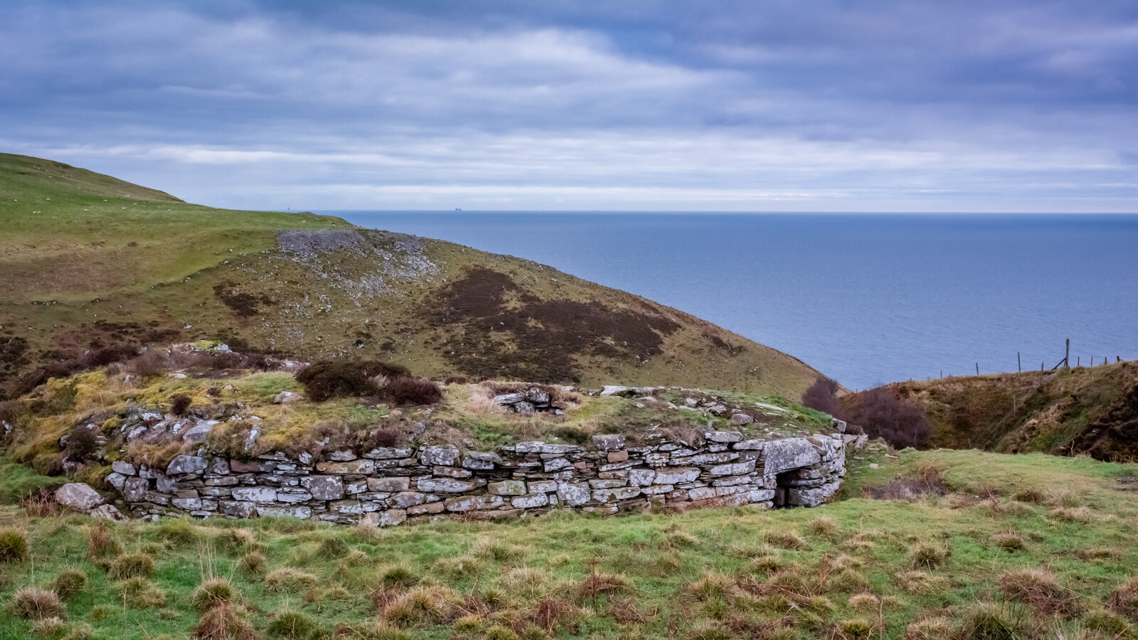
The mound itself is unmistakable once you know what to look for: a grass and vegetation-covered dome rising conspicuously above the flat agricultural surroundings. On a clear day, views extend across the Caithness countryside and toward the coast. The entrance area on the east-southeast side is discernible as a depression or gap in the mound's profile. On the western side, where surveyors once recorded exposed wall face, vegetation may now conceal the stonework, though some stone may still be visible at ground level.
The experience is minimal and maximal simultaneously. There is nothing to read, nothing to buy, no guided narrative. There is only the mound, the landscape, and whatever you bring to the encounter. For those who understand what lies beneath the turf, the site is rich with possibility. For those who do not, it is simply a hill in a field. Both perceptions are accurate.
Upper Borgue Broch lies south of Dunbeath, near the farm of Upper Borgue. Access is via minor roads off the A9. No formal parking or signage exists. Visitors should seek permission from the landowner before exploring the site. The broch is best combined with a visit to Dunbeath Broch, accessible via the well-signed Strath Heritage Trail, approximately three miles to the north.
Upper Borgue Broch represents the unexcavated majority of Caithness brochs. Its significance lies not in what has been discovered but in what remains to be found, and in its role as one element of a landscape-scale pattern of Iron Age settlement.
The site is recorded in the Canmore database and Highland Historic Environment Record as a probable broch, roughly nineteen metres in diameter, constructed on a natural hillock with an encircling outer wall. Royal Commission surveyors noted exposed wall face on the western side and a traceable entrance on the east-southeast. The site has not been excavated. Its condition has deteriorated since the early twentieth-century surveys.
No oral traditions or folk legends are recorded for the site.
No specific esoteric or alternative traditions are associated with Upper Borgue Broch.
Almost everything about this site is unknown. Construction date, duration of occupation, nature of the community, artefact assemblage, internal structural features, and circumstances of abandonment have not been investigated. The broch remains an archaeological blank, its potential preserved beneath turf and vegetation.
Visit planning
Located behind the farm of Upper Borgue, off minor roads south of Dunbeath village on the A9. No formal parking or signage. Private agricultural land; seek landowner permission. Not wheelchair accessible. Nearest public transport: A9 bus stops at Dunbeath. Nearest railway: Helmsdale, approximately 13 miles south.
Limited accommodation in Dunbeath village. More options in Helmsdale (13 miles south) or Wick (24 miles north).
Upper Borgue Broch is on private agricultural land. Visiting requires courtesy toward the landowner, respect for the monument, and practical preparation for rural Caithness conditions.
Sturdy waterproof footwear essential for farmland. Weather-appropriate outdoor clothing.
Photography is appropriate. The mound against the Caithness landscape makes for atmospheric images.
Not appropriate at this unmanaged archaeological site.
Private land. Seek landowner permission. Do not disturb the monument. Close gates. Keep dogs under control around livestock.
Plan your visit
Address
6GF5+G2, Dunbeath KW7 6HA, UK
Hours, fees, and access can change — verify on the official source before you travel. Practical details last checked Jun 2026.
Nearby sacred places
Sacred places within a half-day’s reach. Pilgrims often visit them together: walk one, stay for the other.


Key questions
What pilgrims usually ask
- Why is Upper Borgue Broch considered sacred?
- Discover Upper Borgue Broch, an unexcavated Iron Age broch near Dunbeath in Caithness, Scotland. Part of the densest broch landscape in Britain.
- What should I wear at Upper Borgue Broch?
- Sturdy waterproof footwear essential for farmland. Weather-appropriate outdoor clothing.
- Can I take photos at Upper Borgue Broch?
- Photography is appropriate. The mound against the Caithness landscape makes for atmospheric images.
- How long should I spend at Upper Borgue Broch?
- Thirty minutes including landscape survey from the mound.
- How do you visit Upper Borgue Broch?
- Located behind the farm of Upper Borgue, off minor roads south of Dunbeath village on the A9. No formal parking or signage. Private agricultural land; seek landowner permission. Not wheelchair accessible. Nearest public transport: A9 bus stops at Dunbeath. Nearest railway: Helmsdale, approximately 13 miles south.
- What offerings are appropriate at Upper Borgue Broch?
- Not appropriate at this unmanaged archaeological site.
- What etiquette should visitors follow at Upper Borgue Broch?
- Upper Borgue Broch is on private agricultural land. Visiting requires courtesy toward the landowner, respect for the monument, and practical preparation for rural Caithness conditions.
- What is the history of Upper Borgue Broch?
- The Iron Age community who built Upper Borgue Broch chose a natural hillock and raised a drystone tower roughly nineteen metres in diameter, surrounded by an outer encircling wall. The construction required significant communal labour and engineering skill. The community was part of the broader broch-building culture that dominated Caithness during the middle Iron Age, a culture characterised by the construction of these distinctive circular towers as the centrepieces of settlements.