Dunbeath Broch
An Iron Age tower at the meeting of two waters, possibly the only broch named in a contemporary historical document
Dunbeath, Caithness, United Kingdom

Plan this visit
Practical context before you go
Ninety minutes for a more thorough visit including the broch and nearby features along the strath.
Park at Dunbeath Strath Path Car Park, signed from the A9 at Dunbeath village. Dunbeath is on the A9, approximately 21 miles south of Wick and 113 miles north of Inverness. The trail follows the north bank of the Dunbeath Water. The path is generally well-maintained but includes uneven ground and can be muddy. The broch entrance is low and the interior has uneven flooring, making wheelchair access to the monument difficult. Free access at all times. Stagecoach buses serve Dunbeath on the Inverness-Wick route.
Dunbeath Broch is a freely accessible Scheduled Ancient Monument. The main requirements are respect for the monument fabric and practical preparation for the trail.
At a glance
- Coordinates
- 58.2541, -3.4415
- Type
- Broch
- Suggested duration
- Ninety minutes for a more thorough visit including the broch and nearby features along the strath.
- Access
- Park at Dunbeath Strath Path Car Park, signed from the A9 at Dunbeath village. Dunbeath is on the A9, approximately 21 miles south of Wick and 113 miles north of Inverness. The trail follows the north bank of the Dunbeath Water. The path is generally well-maintained but includes uneven ground and can be muddy. The broch entrance is low and the interior has uneven flooring, making wheelchair access to the monument difficult. Free access at all times. Stagecoach buses serve Dunbeath on the Inverness-Wick route.
Pilgrim tips
- Sturdy walking shoes or boots recommended. Waterproof clothing advisable given Highland weather.
- Unrestricted. The woodland setting and river backdrop provide atmospheric conditions.
- The low entrance requires stooping and the interior has uneven flooring. The site can be muddy after rain. The broch is an ancient monument; do not disturb stones or features.
Overview
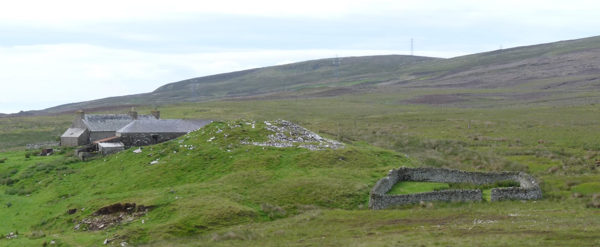
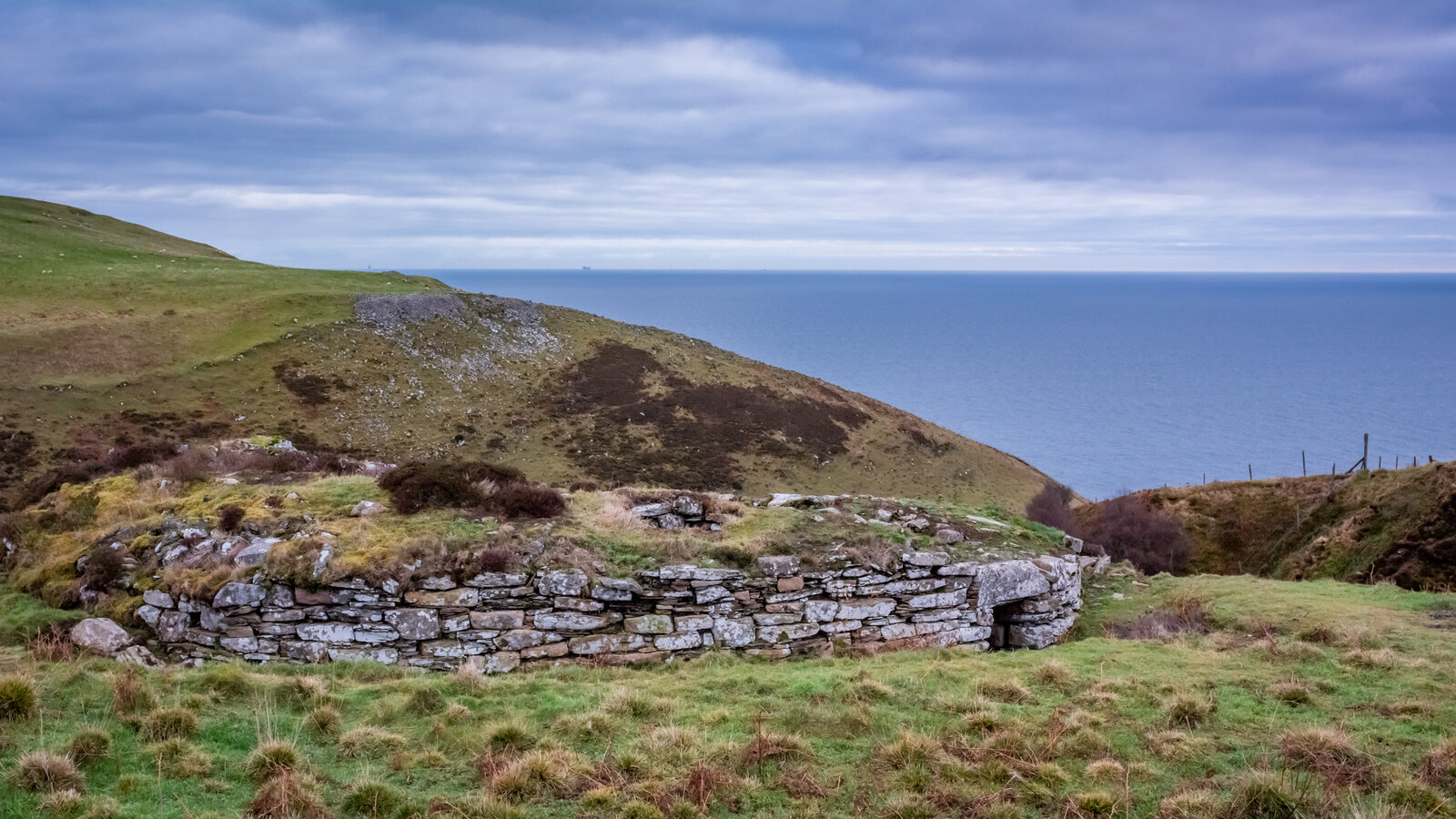
Where the Dunbeath Water meets the Houstry Burn in the strath of Caithness, a drystone tower has stood for over two thousand years. Dunbeath Broch occupies a promontory at the confluence, its walls still rising more than three metres on the western side, its entrance passage still passable, its corbelled inner chamber still intact enough to enter. The walk to reach it follows the Dunbeath Strath Heritage Trail through native woodland along the river, a fifteen-minute approach that unfolds like a gradual departure from the present. If the identification with the Annals of Ulster is correct, this is 'Dun Beata', besieged in 680 CE, making it possibly the only broch in Scotland to appear in a contemporary historical document.
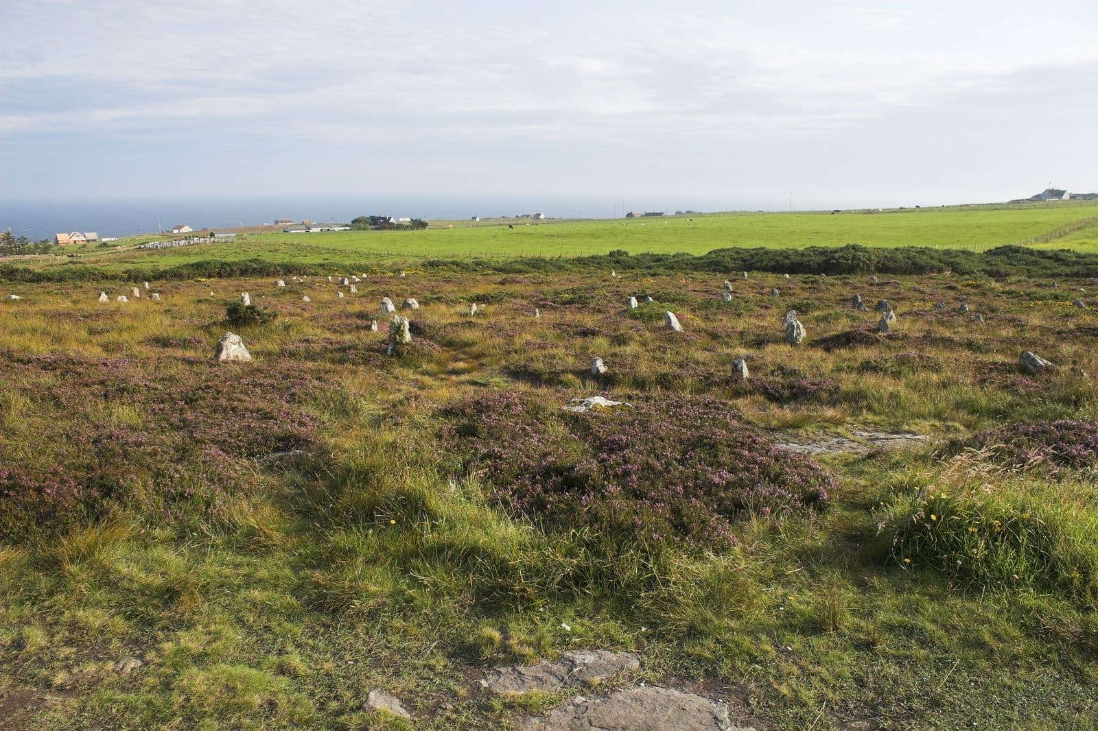
The approach to Dunbeath Broch matters. You begin at the Meal Mill car park in Dunbeath village, itself a small settlement on the A9 coast of Caithness, and walk upstream along the north bank of the Dunbeath Water. The path passes through native woodland, birch and hazel and rowan, the kind of trees that would have grown here when the broch was built. The river accompanies you. Prehistoric cairns and standing stones mark the strath. This is the landscape that inspired Neil Gunn's novel Highland River, and the walk has a similar quality of deepening attention.
When the broch appears, it stands on a promontory where two waters converge. The position is strategic, defensive and commanding, but also liminal: a point where separate streams become one. The walls survive to over three metres on the western side. The entrance passage is low, requiring you to stoop, an architectural decision that was deliberate rather than accidental. Stooping to enter is itself a kind of threshold ritual, a physical acknowledgment that you are crossing into a different kind of space.
Inside, the corbelled chamber retains enough of its original form to feel enclosed. A guard cell opens off the entrance passage. An intra-mural cell, probably added around the first century BCE or CE, is visible in the wall. The scarcement ledge, a projecting stone course that supported an upper floor, confirms this was a multi-storey dwelling. The 2018 AOC Archaeology excavation revealed an alcove in the west wall containing burnt bone and charcoal, a deposit that has not yet been fully investigated.
Dunbeath Broch is one of the best-preserved brochs in Caithness and benefits from recent conservation work. The Berriedale and Dunbeath Community Council, supported by AOC Archaeology and the Heritage Lottery Fund, undertook major consolidation in 2018, stabilising walls and investigating the structure. This work revealed that the southern half of the broch had suffered catastrophic collapse in antiquity and been almost entirely rebuilt, evidence of a community's determination to maintain their monument.
Context and lineage
The Iron Age community who built Dunbeath Broch chose a promontory at the convergence of two watercourses, a position offering both natural defence and commanding views along the strath. The name 'Dun Beath' derives from Gaelic, meaning 'fort of the birch trees', connecting the structure to the woodland that has characterised this part of the strath for millennia. The broch's construction required sophisticated engineering: walls 4.3 metres thick at the entrance, double-wall design with internal galleries, corbelled chambers, and multi-storey elevation. The community possessed both the technical skill and the social organisation to undertake such a project.
No continuous tradition connects the Iron Age builders to the present. The broch may have continued in use or been reoccupied into the early medieval period, as suggested by the possible Annals of Ulster reference. The structure was 'rediscovered' by antiquarians in the nineteenth century and has been a heritage landmark since. The 2018 conservation project, led by the Berriedale and Dunbeath Community Council, represents a modern reconnection of the local community with its ancestral architecture.
WST Sinclair of Dunbeath Castle
AOC Archaeology Group
Why this place is sacred
There is a particular quality to the walk along the Dunbeath Water. The woodland closes around you. The river speaks. The path, following the north bank, takes you upstream, against the current, back in time. By the time the broch appears on its promontory, you have already left the A9, the village, the ordinary world behind. This is not accidental. Heritage trails can be designed for efficiency, but this one works because it demands time and attention.
The broch itself stands at a meeting of waters. In many traditions across the Celtic and pre-Celtic world, confluences were understood as places of power, thresholds where different forces converged. Whether the Iron Age builders of Dunbeath consciously chose this location for its symbolic properties or simply recognised its defensive advantages cannot be determined. Perhaps the distinction would not have made sense to them. A place that was strong might also be sacred; a place of defence might also be a place of meeting, of ceremony, of meaning.
The 680 CE entry in the Annals of Ulster, recording the siege of 'Dun Beata', adds another layer. If this reference identifies this specific broch, then the structure was still important enough to be fought over six centuries after brochs ceased to be built. The name itself, from the Gaelic for 'fort of the birch trees', connects to the woodland that still surrounds the site. Trees and tower and water have been here together for a very long time.
The corbelled inner chamber is the site's most intimate space. Low, enclosed, insulated from wind and river sound, it creates a stillness that visitors consistently note. Standing within walls built two millennia ago, in a space never exposed to the open sky since its construction, you are enclosed by the work of people who understood stone, who knew how to make it hold against time.
Archaeological consensus identifies the broch as a high-status Iron Age dwelling, likely the fortified residence of a local chieftain or prominent family. The promontory location offered natural defence at the convergence of two watercourses. The scale and sophistication of construction, including double walls 4.3 metres thick at the entrance, a guarded entrance passage, intra-mural cells, and a multi-storey design, indicate significant social status and engineering capability.
The broch underwent major modification during its lifetime. After catastrophic collapse of the southern half, probably during the later Iron Age, the structure was almost entirely rebuilt on that side. An intra-mural cell was added, probably around the first century BCE or CE. If the Annals of Ulster reference is correct, the site was still defensible in 680 CE. The first antiquarian investigation occurred in 1866 when WST Sinclair of Dunbeath Castle cleared rubble from the interior. The University of Glasgow undertook consolidation in 1990. AOC Archaeology led major conservation and excavation in 2018.
Traditions and practice
Iron Age practices at Dunbeath are inferred from excavation finds and comparable sites. Animal bone, stone implements, and an iron spearhead from the 1866 excavation suggest domestic and possibly martial activities. The 2018 excavation discovered burnt bone and charcoal in an alcove, but this deposit has not been fully investigated. Whether these represent domestic, ritual, or funerary activities is unknown.
No established spiritual communities maintain practice at the broch. The site is visited by walkers, archaeology enthusiasts, and literary pilgrims following the Neil Gunn connection to Dunbeath Strath. The Dunbeath Heritage Museum, open April through September, provides displays and information.
Walk the full Strath Heritage Trail to experience the approach as preparation. Enter the broch through the original low doorway and take time in the interior to let the space register. Observe the construction details: the guard cell, the wall thickness, the scarcement ledge. The confluence setting invites quiet contemplation of the meeting of waters and the meeting of past and present.
Iron Age Broch Culture
HistoricalDunbeath Broch was constructed as a substantial drystone tower during the Iron Age, part of the distinctive broch-building tradition unique to Scotland. Its position on a promontory at a river confluence, with walls over four metres thick and multi-storey design, indicates high-status occupation. The catastrophic collapse and rebuilding of the southern half demonstrates the community's commitment to maintaining the structure.
The broch served as a fortified dwelling for an Iron Age household. Evidence of animal husbandry, tool use, and possibly warfare has been recovered. The guard cell in the entrance passage suggests controlled access. The central hearth would have been the focal point of daily life.
Experience and perspectives
The trail begins at the Meal Mill car park in Dunbeath village, signed from the A9. The path follows the north bank of the Dunbeath Water through woodland, past interpretation panels that provide historical context. Prehistoric cairns are visible along the route. The river, clear and fast-moving, is a constant companion. The atmosphere shifts gradually from village to wild landscape.
The broch appears as you round a bend, standing on its promontory where the Houstry Burn joins the main river. Trees partially surround it, unusual for Caithness brochs, which typically stand in open moorland. This wooded setting creates enclosure and shelter. The walls are impressive, particularly on the western side where they stand over three metres high. The entrance passage faces east, toward the confluence.
To enter, you stoop through the low doorway, just as Iron Age inhabitants did. The guard cell opens immediately to one side, a small chamber where someone once controlled access. The interior of the tower, though roofless, retains its circular form. The scarcement ledge that supported an upper floor is visible. The 2018 excavation revealed features including a niche in the entrance passage, likely part of a door mechanism, and the unexplored alcove with burnt bone in the west wall.
The sounds inside the broch are different from outside. The walls, thick enough to absorb wind and river noise, create a partial silence. Light enters from above and through the passage. The effect is of standing within a space that was designed for enclosure, for privacy, for the particular intimacy of a dwelling that was also a statement of power.
Start at the Dunbeath Strath Path Car Park, signed from the A9 at Dunbeath village. The trail is approximately 800 metres each way. Interpretation panels provide context. The Dunbeath Heritage Museum in the village, open April through September, offers additional background. The broch can be combined with exploration of the wider strath, including Prisoner's Leap gorge, standing stones, and prehistoric cairns.
Dunbeath Broch offers multiple entries into the past. As architecture, it demonstrates sophisticated Iron Age engineering. As landscape feature, it marks a significant confluence. As possible historical site, it may connect anonymous prehistory to the earliest written records of Scotland. As community heritage, it represents a modern reconnection with ancestral structures.
Archaeologists classify Dunbeath as a well-preserved middle Iron Age broch. Wall thickness at the entrance is 4.3 metres, interior diameter approximately 8 metres, walls surviving to over 3 metres. The 2018 AOC Archaeology excavation revealed that the southern half suffered catastrophic collapse and was near-completely rebuilt, and that an intra-mural cell was added later. An alcove in the west wall containing burnt bone and charcoal was left unexcavated. The 1866 excavation recovered animal bone, stone implements, and an iron spearhead. The identification with 'Dun Beata' in the Annals of Ulster (680 CE) is plausible but not universally accepted.
No indigenous oral tradition survives from the broch builders. The name 'Dun Beath' preserves a Gaelic description, 'fort of the birch trees', connecting the site to its woodland setting. Neil Gunn's literary work, particularly Highland River, draws on the Dunbeath Strath landscape, creating a modern literary tradition associated with the place.
Some visitors interpret brochs as having ceremonial or astronomical functions beyond domestic use. The confluence location and circular form resonate with ideas about sacred architecture. No specific esoteric tradition is documented for Dunbeath.
The exact date and cause of the catastrophic collapse remain unknown. The alcove with burnt bone in the west wall is uninvestigated. Whether 'Dun Beata' in the Annals of Ulster definitively refers to this broch cannot be confirmed. A possible human vertebra from the 1866 excavation raises questions about human remains at the site. The function of brochs, whether primarily defensive, domestic, symbolic, or ritual, remains Scotland's great archaeological debate.
Visit planning
Park at Dunbeath Strath Path Car Park, signed from the A9 at Dunbeath village. Dunbeath is on the A9, approximately 21 miles south of Wick and 113 miles north of Inverness. The trail follows the north bank of the Dunbeath Water. The path is generally well-maintained but includes uneven ground and can be muddy. The broch entrance is low and the interior has uneven flooring, making wheelchair access to the monument difficult. Free access at all times. Stagecoach buses serve Dunbeath on the Inverness-Wick route.
Limited accommodation in Dunbeath village, including B&Bs. More options in Helmsdale (20 miles south) or Wick (21 miles north). The area is on the A9 route.
Dunbeath Broch is a freely accessible Scheduled Ancient Monument. The main requirements are respect for the monument fabric and practical preparation for the trail.
Sturdy walking shoes or boots recommended. Waterproof clothing advisable given Highland weather.
Unrestricted. The woodland setting and river backdrop provide atmospheric conditions.
Not appropriate. Visitors should not leave offerings or disturb the archaeological remains.
Do not damage the scheduled monument. Do not climb on walls or remove any material. Close gates. Keep dogs under control.
Plan your visit
Address
Dunbeath KW6 6EJ, UK
Hours
Hours, fees, and access can change — verify on the official source before you travel. Practical details last checked Jun 2026.
Nearby sacred places
Sacred places within a half-day’s reach. Pilgrims often visit them together: walk one, stay for the other.
References
Sources consulted when researching this page. Independent verification by readers is welcome.
- 01Dun Beath - Canmore (Historic Environment Scotland) — Historic Environment Scotlandhigh-reliability
- 02MHG1144 - Broch, Dun Beath - Highland Historic Environment Record — Highland Councilhigh-reliability
- 03Dunbeath Broch Project - Consolidation, Excavation, Outreach — AOC Archaeology Grouphigh-reliability
- 04Grand Redesigns: a History of Remodelling at Dunbeath Broch — AOC Archaeology Grouphigh-reliability
- 05Dunbeath Broch Project - Berriedale & Dunbeath Community Council — Berriedale & Dunbeath Community Councilhigh-reliability
- 06Dun Beath Broch - Dunbeath Heritage Museum — Dunbeath Preservation Trusthigh-reliability
- 07Dunbeath Broch: Explore Caithness's Best-Preserved Iron Age Broch — Live Breathe Scotland
- 08Dunbeath Broch - The Megalithic Portal — The Megalithic Portal
- 09Three Brochs to Visit in Caithness - NorthLink Ferries — NorthLink Ferries
- 10Dun Beath - Broch in Latheron, Caithness — Stravaiging around Scotland
Key questions
What pilgrims usually ask
- Why is Dunbeath Broch considered sacred?
- Visit Dunbeath Broch, one of Caithness's best-preserved Iron Age brochs. Walk the heritage trail through native woodland to this 2,000-year-old drystone tower a
- What should I wear at Dunbeath Broch?
- Sturdy walking shoes or boots recommended. Waterproof clothing advisable given Highland weather.
- Can I take photos at Dunbeath Broch?
- Unrestricted. The woodland setting and river backdrop provide atmospheric conditions.
- How long should I spend at Dunbeath Broch?
- Ninety minutes for a more thorough visit including the broch and nearby features along the strath.
- How do you visit Dunbeath Broch?
- Park at Dunbeath Strath Path Car Park, signed from the A9 at Dunbeath village. Dunbeath is on the A9, approximately 21 miles south of Wick and 113 miles north of Inverness. The trail follows the north bank of the Dunbeath Water. The path is generally well-maintained but includes uneven ground and can be muddy. The broch entrance is low and the interior has uneven flooring, making wheelchair access to the monument difficult. Free access at all times. Stagecoach buses serve Dunbeath on the Inverness-Wick route.
- What offerings are appropriate at Dunbeath Broch?
- Not appropriate. Visitors should not leave offerings or disturb the archaeological remains.
- What etiquette should visitors follow at Dunbeath Broch?
- Dunbeath Broch is a freely accessible Scheduled Ancient Monument. The main requirements are respect for the monument fabric and practical preparation for the trail.
- What is the history of Dunbeath Broch?
- The Iron Age community who built Dunbeath Broch chose a promontory at the convergence of two watercourses, a position offering both natural defence and commanding views along the strath. The name 'Dun Beath' derives from Gaelic, meaning 'fort of the birch trees', connecting the structure to the woodland that has characterised this part of the strath for millennia. The broch's construction required sophisticated engineering: walls 4.3 metres thick at the entrance, double-wall design with internal galleries, corbelled chambers, and multi-storey elevation. The community possessed both the technical skill and the social organisation to undertake such a project.