Ousdale Broch
A recently conserved Iron Age tower where mainland and Atlantic traditions meet, in a remote coastal burn valley
Helmsdale, Caithness, United Kingdom

Plan this visit
Practical context before you go
Ninety minutes to explore the broch thoroughly and visit the nearby Borg village ruins.
Located between Helmsdale and Berriedale, accessed from the old A9 road. The modern A9 passes nearby but does not stop at the site. Small parking area near the old road. The gravel path descends into the burn valley. Not wheelchair accessible. Limited public transport; the nearest bus stops are on the A9 at Berriedale or Helmsdale. Nearest railway station: Helmsdale.
Ousdale Broch is a freely accessible Scheduled Ancient Monument that has undergone recent conservation. The main requirements are respect for the conservation work and practical preparation for the walk.
At a glance
- Coordinates
- 58.1484, -3.5798
- Type
- Broch
- Suggested duration
- Ninety minutes to explore the broch thoroughly and visit the nearby Borg village ruins.
- Access
- Located between Helmsdale and Berriedale, accessed from the old A9 road. The modern A9 passes nearby but does not stop at the site. Small parking area near the old road. The gravel path descends into the burn valley. Not wheelchair accessible. Limited public transport; the nearest bus stops are on the A9 at Berriedale or Helmsdale. Nearest railway station: Helmsdale.
Pilgrim tips
- Sturdy footwear recommended for the path and broch interior. Waterproof and windproof layers advisable.
- Permitted throughout. The sheltered valley setting provides good photographic conditions.
- The path can be slippery in wet conditions. The broch interior has uneven ground. Do not disturb the consolidated stonework.
Overview
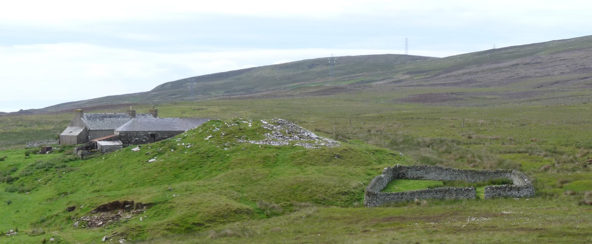
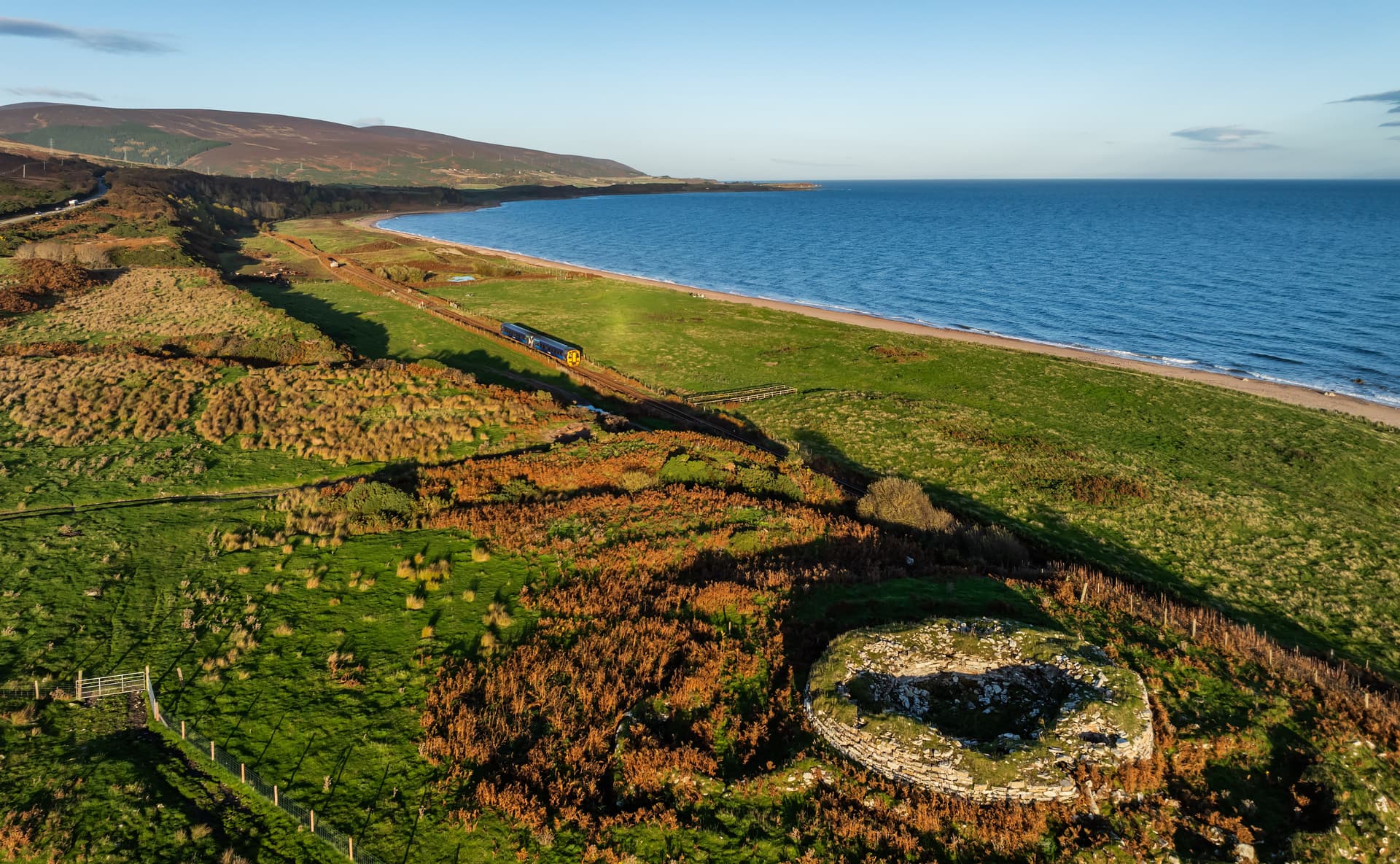
In a sheltered valley where the Ousdale Burn cuts toward the sea, between the villages of Helmsdale and Berriedale on the Caithness-Sutherland border, a broch stands that was until recently in danger of collapse. Conservation work by the Caithness Broch Project between 2015 and 2020 stabilised the structure, revealing a tower with walls still standing around three metres high, two corbelled guard cells, an original stairwell, and an aumbry. The artefacts recovered from earlier investigations tell a story of a community at the intersection of two broch-building traditions: the mainland Scottish and the Atlantic. Ousdale Broch sits at a cultural boundary as well as a geographic one.
The walk to Ousdale Broch follows the old A9 road, now a quiet track since the modern road was rerouted, before descending into the burn valley on a gravel path installed as part of the conservation project. Interpretation signs along the route provide context. The approach is atmospheric: the coastal landscape gives way to a sheltered valley where the burn runs toward the sea, and the broch appears as a substantial stone ruin on the valley floor.
Ousdale Broch is one of the success stories of community archaeology in Scotland. Before conservation work began in 2015, the structure was in serious disrepair, its walls leaning and its future uncertain. The Caithness Broch Project, working with Historic Environment Scotland and local volunteers, undertook a multi-year programme of consolidation that saved the broch and opened it to visitors for the first time in the modern era. The work revealed original features including a stairwell within the wall thickness, two corbelled guard cells flanking the entrance passage, and an aumbry, a small cupboard-like recess in the wall.
The artefacts recovered from earlier investigations are particularly telling. Pottery fragments, a metalworking crucible, polished lignite, a segment of a jet armlet, and a portion of a wooden dish or scoop indicate a community engaged in both craft production and trade. The material culture represents a blend of mainland and Atlantic Iron Age traditions, perhaps reflecting Ousdale's position at the border between Caithness and Sutherland, where two different broch-building archaeological cultures met. Layers of ash and charcoal on the floor, broken animal bones, periwinkle and limpet shells, and wild hazelnuts speak of a domestic life centred on farming, foraging, and the sea.
Context and lineage
The Iron Age community who built Ousdale Broch chose a sheltered position in a coastal burn valley, with access to both agricultural land and the sea. The builders constructed a substantial drystone tower with sophisticated features including double walls, guard cells, and an internal staircase. The community was engaged in farming, foraging, fishing, and craft production, including metalworking. Their material culture drew on both mainland and Atlantic Iron Age traditions, reflecting the site's position at a cultural crossroads.
No continuous tradition connects the Iron Age builders to the present. The broch was abandoned at an unknown date and gradually deteriorated over centuries. The site was known to antiquarians and recorded in heritage databases. The Caithness Broch Project's conservation work represents a modern reconnection, transforming the broch from a declining ruin into an accessible heritage site.
Caithness Broch Project
AOC Archaeology Group
Why this place is sacred
There is a particular quality to sites that have been saved. Ousdale Broch came close to being lost, its walls leaning and collapsing, its features gradually obscured by rubble and vegetation. The conservation work that began in 2015 was not a reconstruction but a stabilisation, a holding-in-place of what remained. This distinction matters. What you see at Ousdale is authentic: the original stairwell, the corbelled guard cells, the aumbry. Nothing has been rebuilt to create an impression. The impression comes from reality.
The remoteness of the site contributes to its atmosphere. This is not a broch you stumble upon while driving the A9. You must know it is there, seek it out, walk down into the valley. The old A9 road, now a track, provides a transitional space between the modern world and the broch's valley. The descent along the gravel path takes you below the level of the surrounding landscape, into a sheltered space where the burn and the broch have kept company for two millennia.
The boundary quality of the site is less obvious but equally significant. Ousdale sits at the border between Caithness and Sutherland, and the artefacts recovered from the broch reflect both mainland and Atlantic Iron Age traditions. The community that lived here existed at an intersection, and the material evidence of their life reflects that position. Cultural borders, like geographic ones, are places where different ways of being meet and sometimes merge. Ousdale was such a place.
Archaeological evidence indicates a domestic Iron Age settlement. The broch served as a fortified dwelling for a community engaged in farming, foraging, fishing, and craft production. The metalworking crucible suggests the production of metal objects, indicating either local expertise or access to itinerant metalworkers. The blend of mainland and Atlantic artefact traditions reflects the site's position at a cultural intersection.
The broch was constructed during the Iron Age, probably between 200 BCE and 200 CE. It was occupied long enough for substantial domestic deposits to accumulate: ash, charcoal, animal bone, shell middens. After abandonment, the structure gradually deteriorated over centuries. The Caithness Broch Project's conservation work between 2015 and 2020 stabilised the walls, installed access paths, and added interpretation signs. A 3D laser scan was conducted by AOC Archaeology, creating a digital record of the structure.
Traditions and practice
Excavation evidence indicates domestic activities including food preparation (animal bone, shellfish, hazelnuts), metalworking (crucible), and personal adornment (jet armlet fragment). Specific ritual or ceremonial practices are not directly evidenced but may be reflected in structured deposits or features not yet fully investigated.
No spiritual communities maintain practice at the broch. The site is visited by walkers, archaeology enthusiasts, and North Coast 500 travellers. The Caithness Broch Project occasionally organises events and walks in the area.
Allow the descent into the burn valley to serve as a transition. Explore the broch's features carefully: the guard cells, the stairwell, the aumbry. Consider the domestic evidence, the shells and bones and hazelnuts, that connects you to the daily life of the inhabitants. The sound of the burn and the shelter of the valley create natural conditions for quiet reflection.
Iron Age Broch Culture
HistoricalOusdale Broch represents Iron Age settlement at a cultural boundary between mainland and Atlantic broch-building traditions. The artefact assemblage reflects both influences, making the site archaeologically significant for understanding cultural contact in prehistoric Scotland. The community practised mixed subsistence, combining farming, foraging, fishing, and craft production.
Domestic life centred on the hearth within the broch tower. Evidence of food preparation, metalworking, personal adornment, and stone tool use has been recovered. The guard cells and entrance design suggest controlled access and defensive awareness.
Experience and perspectives
The walk begins from a parking area near the old A9 road between Helmsdale and Berriedale. The modern A9 was rerouted away from the coast here, leaving the old road as a quiet track. From this track, a gravel path descends into the Ousdale Burn valley, with interpretation signs explaining the broch, its archaeology, and the conservation project.
The broch appears below you as you descend, a circular ruin of grey stone standing near the burn. The sheltered position is immediately apparent: the valley walls provide protection from the coastal winds that batter the surrounding landscape. The builders chose this site for its combination of shelter, water access, and defensibility.
Inside the broch, the conservation work has made the original features clearly visible. The two corbelled guard cells flank the entrance passage, their stone roofs intact after two thousand years. The stairwell within the wall thickness led to upper floors now vanished. The aumbry, a small cupboard-like recess, is set into the wall at roughly chest height. These domestic details make the broch feel inhabited, not in the sense that anyone lives here now, but in the sense that you can imagine what it was like when someone did.
The burn provides a constant soundtrack. The valley walls frame the sky. On a clear day, you can see the sea from the approach. On a grey day, the broch seems to merge with the landscape, stone returning to stone.
The broch is accessed from the old A9 road between Helmsdale and Berriedale. Look for signage directing you to the parking area. The walk is approximately fifteen to twenty minutes each way. The site can be combined with visits to nearby ruins of the cleared township of Borg, visible in the valley.
Ousdale Broch is both an archaeological site and a conservation success story. Its significance lies in the intersection of cultural traditions revealed by its artefacts, the quality of its surviving architectural features, and the community effort that saved it from destruction.
Archaeologists recognise Ousdale as an important example of an Iron Age broch with material culture reflecting both mainland and Atlantic traditions, making it significant for understanding cultural contact in prehistoric Scotland. The conservation work revealed original features in remarkable condition, including two corbelled guard cells, a stairwell, and an aumbry. The artefact assemblage, including pottery, a metalworking crucible, polished lignite, a jet armlet fragment, and a wooden dish, indicates a community engaged in craft production and trade.
No indigenous oral tradition survives from the broch builders. The Gaelic name Allt a' Bhurg, meaning 'stream of the fort', preserves awareness of the broch in later Gaelic-speaking communities.
Some visitors experience the sheltered burn valley as a natural sanctuary, and the broch's position in this enclosed space resonates with ideas about sacred landscape. No specific esoteric tradition is documented for Ousdale.
The exact dates of construction and abandonment are not firmly established. The relationship between the broch community and contemporary settlements in the area is unclear. Whether the blend of mainland and Atlantic artefact traditions reflects a mixed-origin community, trade networks, or cultural exchange is debated. The broch's relationship to the nearby cleared township of Borg, which postdates it by many centuries, raises questions about continuity of settlement in the valley.
Visit planning
Located between Helmsdale and Berriedale, accessed from the old A9 road. The modern A9 passes nearby but does not stop at the site. Small parking area near the old road. The gravel path descends into the burn valley. Not wheelchair accessible. Limited public transport; the nearest bus stops are on the A9 at Berriedale or Helmsdale. Nearest railway station: Helmsdale.
Accommodation available in Helmsdale, approximately 8 miles south, including hotels and B&Bs. Limited options in Berriedale.
Ousdale Broch is a freely accessible Scheduled Ancient Monument that has undergone recent conservation. The main requirements are respect for the conservation work and practical preparation for the walk.
Sturdy footwear recommended for the path and broch interior. Waterproof and windproof layers advisable.
Permitted throughout. The sheltered valley setting provides good photographic conditions.
Not appropriate. Leave no trace at this archaeological site.
Do not damage the monument or conservation work. Do not climb on walls or remove material. Close any gates. Keep dogs under control.
Plan your visit
Address
Berriedale KW7 6HD, UK
Hours
Hours, fees, and access can change — verify on the official source before you travel. Practical details last checked Jun 2026.
Nearby sacred places
Sacred places within a half-day’s reach. Pilgrims often visit them together: walk one, stay for the other.


Key questions
What pilgrims usually ask
- Why is Ousdale Broch considered sacred?
- Visit Ousdale Broch, a recently conserved Iron Age tower between Helmsdale and Berriedale in Caithness. Explore guard cells, a stairwell, and 2,000 years of his
- What should I wear at Ousdale Broch?
- Sturdy footwear recommended for the path and broch interior. Waterproof and windproof layers advisable.
- Can I take photos at Ousdale Broch?
- Permitted throughout. The sheltered valley setting provides good photographic conditions.
- How long should I spend at Ousdale Broch?
- Ninety minutes to explore the broch thoroughly and visit the nearby Borg village ruins.
- How do you visit Ousdale Broch?
- Located between Helmsdale and Berriedale, accessed from the old A9 road. The modern A9 passes nearby but does not stop at the site. Small parking area near the old road. The gravel path descends into the burn valley. Not wheelchair accessible. Limited public transport; the nearest bus stops are on the A9 at Berriedale or Helmsdale. Nearest railway station: Helmsdale.
- What offerings are appropriate at Ousdale Broch?
- Not appropriate. Leave no trace at this archaeological site.
- What etiquette should visitors follow at Ousdale Broch?
- Ousdale Broch is a freely accessible Scheduled Ancient Monument that has undergone recent conservation. The main requirements are respect for the conservation work and practical preparation for the walk.
- What is the history of Ousdale Broch?
- The Iron Age community who built Ousdale Broch chose a sheltered position in a coastal burn valley, with access to both agricultural land and the sea. The builders constructed a substantial drystone tower with sophisticated features including double walls, guard cells, and an internal staircase. The community was engaged in farming, foraging, fishing, and craft production, including metalworking. Their material culture drew on both mainland and Atlantic Iron Age traditions, reflecting the site's position at a cultural crossroads.