Kilphedir Broch
A pink granite tower high above the Strath of Kildonan, surrounded by the most impressive defensive outworks in Sutherland
Kilphedir, Sutherland, United Kingdom

Plan this visit
Practical context before you go
One hour including a full circuit of the defensive outworks and time on the hilltop.
Located near Kilphedir Lodge on the north side of the Strath of Kildonan, off the A897 northwest of Helmsdale. No formal parking or signage. The approach involves crossing open ground and climbing the hillock. Not wheelchair accessible. Nearest town: Helmsdale, approximately 8 miles southeast on the A9. Very limited public transport; car access essential. Nearest railway station: Kildonan (on the Inverness-Thurso line), approximately 2 miles north.
Kilphedir Broch is on open land in the Strath of Kildonan. Basic countryside courtesy and respect for the monument apply.
At a glance
- Coordinates
- 58.1476, -3.7102
- Type
- Broch
- Suggested duration
- One hour including a full circuit of the defensive outworks and time on the hilltop.
- Access
- Located near Kilphedir Lodge on the north side of the Strath of Kildonan, off the A897 northwest of Helmsdale. No formal parking or signage. The approach involves crossing open ground and climbing the hillock. Not wheelchair accessible. Nearest town: Helmsdale, approximately 8 miles southeast on the A9. Very limited public transport; car access essential. Nearest railway station: Kildonan (on the Inverness-Thurso line), approximately 2 miles north.
Pilgrim tips
- Sturdy waterproof boots essential for the rough terrain. Full Highland weather gear advisable.
- Permitted. The pink granite and panoramic views provide distinctive photographic subjects.
- The site is unmanaged and involves rough terrain. The ditch and ramparts can be hazardous, particularly in wet conditions. The broch walls are in a ruinous state; do not climb on them.
Overview
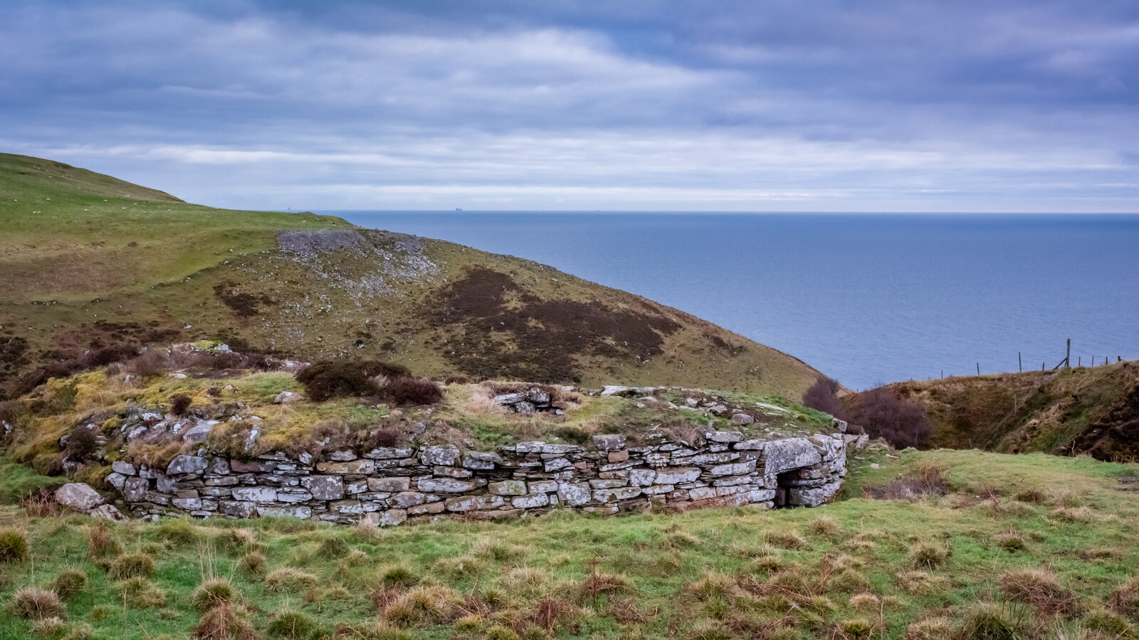
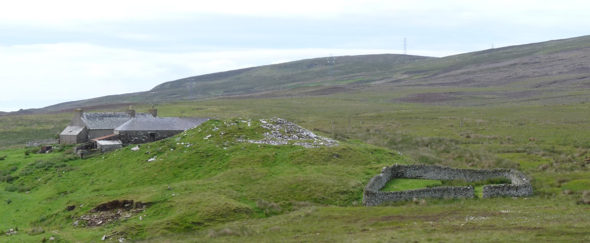
High on a hillock above the Strath of Kildonan in Sutherland, a broch of pink granite commands views up and down the valley. Kilphedir Broch is one of the most impressive brochs in the Highlands, distinguished not only by its dramatic position but by the enormous banks and ditches that surround it, probably the most formidable defensive outworks of any broch in Sutherland. Built from large rounded boulders of local pink granite, the broch has a distinctive appearance unlike the flat flagstone construction typical of Caithness brochs to the north. The material, though beautiful, is notoriously difficult to build with, and may have contributed to the structure's present ruinous state.
The Strath of Kildonan runs northwestward from the coast at Helmsdale into the interior of Sutherland, following the course of the River Helmsdale. It is a landscape shaped by water and ice, a broad valley flanked by hills, with the river as its spine. Kilphedir Broch stands high above this strath on a hillock that provides commanding views in both directions, a position that would have allowed its inhabitants to observe movement along the valley for miles.
The broch itself measures approximately ten metres across internally, within walls averaging over a metre in thickness. The entrance, roughly ninety centimetres wide at the exterior and widening to nearly 1.5 metres at the interior, faces the valley. The construction material sets Kilphedir apart from its Caithness neighbours: large, rounded boulders of pink granite, quarried or gathered locally, which give the ruin a warm colour quite different from the grey flagstone of brochs further north. This granite, while visually striking, presents difficulties for drystone construction. Rounded boulders do not stack as neatly as flat flagstone slabs, and this may account for the broch's relatively advanced state of deterioration.
But it is the defensive outworks that truly distinguish Kilphedir. The base of the hillock is encircled by a ditch nearly three metres deep, cut outside an outer rampart over four metres broad. These earthworks, combined with the natural height of the hillock and an extra length of rampart protecting the entrance, create a layered defensive system that exceeds anything seen at other Sutherland brochs. Whether this reflects a particularly threatened community, a particularly powerful chief, or a cultural preference for elaborate defences cannot be determined from the evidence available.
Context and lineage
The Iron Age community who built Kilphedir Broch chose the highest natural feature in their section of the strath and raised upon it a drystone tower with the most elaborate defensive outworks in Sutherland. Their choice of pink granite, while locally available, presented engineering challenges that builders of flagstone brochs did not face. The investment in both tower and defences indicates a community of considerable resources and determination, occupying a strategically significant position in the valley.
No continuous tradition connects the Iron Age builders to the present. The Strath of Kildonan was subject to Highland Clearances in the early nineteenth century, which depopulated much of the valley. The 1860s Kildonan gold rush brought temporary activity. Today, the strath is sparsely populated, and the broch stands as a reminder of a time when the valley supported a community powerful enough to build monumental architecture.
RCAHMS surveyors
Why this place is sacred
There are sites whose power lies in concealment and enclosure, and sites whose power lies in exposure and command. Kilphedir belongs to the second category. This is a broch built to see and be seen. Its position on a hillock high above the strath was chosen for maximum visibility, and the views from the ruin encompass miles of valley in both directions. Standing here, you understand immediately why this location was chosen: it controls the valley visually, and with the defensive outworks, it controls it physically as well.
The pink granite adds an unexpected dimension. Most brochs in the Scottish Highlands are built from grey stone, whether flagstone or schist, and they blend into their landscapes like geological features. Kilphedir's granite gives it warmth and colour, particularly in low sunlight when the pink tones deepen. The rounded boulders also give the ruin a texture quite different from the precise flagstone courses of Caithness brochs. There is something more organic about it, as though the tower grew from the hillock rather than being placed upon it.
The defensive outworks raise questions that the site cannot answer. Who were these people afraid of? What threatened the Strath of Kildonan during the Iron Age? The ditch, nearly three metres deep, and the rampart, over four metres broad, represent a massive investment of labour, far exceeding the typical broch defensive arrangements. This suggests either genuine military necessity or a desire to project power and deterrence on an exceptional scale. Either way, the outworks speak of a world more uncertain and more contested than the quiet strath suggests today.
The broch served as a fortified dwelling, probably for a local chief or prominent family. The exceptional defensive outworks suggest a community with significant defensive concerns or an unusually powerful leader capable of commanding the labour to construct such elaborate earthworks. The commanding position over the Strath of Kildonan implies a role in controlling or monitoring movement along the valley.
The broch was constructed during the Iron Age, probably between 200 BCE and 200 CE. The use of pink granite, while locally available, represents an unusual choice that may reflect local building traditions or the absence of more suitable stone. The defensive outworks may be contemporary with the broch or may represent later additions. The site has been surveyed but not systematically excavated in modern times. It is recorded in the Canmore database and Highland Historic Environment Record.
Traditions and practice
Iron Age practices at the site are unknown. The exceptional defensive outworks suggest a community concerned with defence, possibly involved in territorial control of the strath. By analogy with other brochs, the inhabitants likely practised mixed farming and animal husbandry.
No contemporary spiritual or heritage practices are associated with the site. Occasional walkers and archaeology enthusiasts visit.
The commanding hilltop position makes this a natural place for survey and contemplation. Take time to appreciate the scale of the defensive outworks, which are best understood by walking the full circuit of the hillock. The views up and down the strath provide context for the broch's strategic significance.
Iron Age Broch Culture
HistoricalKilphedir Broch represents Iron Age settlement in the Strath of Kildonan, with exceptional defensive outworks that suggest a community of unusual power or vulnerability. The pink granite construction distinguishes it from Caithness brochs and reflects local Sutherland building traditions.
The community likely practised mixed farming and animal husbandry, with the broch serving as a fortified dwelling and status symbol. The elaborate defences suggest military or territorial concerns beyond the typical broch settlement. Specific practices at Kilphedir are unknown.
Experience and perspectives
Reaching Kilphedir Broch requires navigating to the Strath of Kildonan, a broad valley running northwest from Helmsdale along the course of the River Helmsdale. The broch stands near Kilphedir Lodge, on the north side of the strath, on a hillock that is visible from the valley floor.
The approach crosses open ground and involves an ascent to the hillock. As you climb, the defensive outworks become apparent: the broad ditch encircling the base, the rampart beyond it, the extra defensive element protecting the entrance. These are not subtle features. They are large-scale earthworks that would have been formidable obstacles to any attacker approaching the broch.
The broch itself, reached after crossing the ditch and climbing through the defences, rewards with its distinctive pink granite construction and commanding panoramic views. The walls, though ruinous, are substantial enough to convey the scale of the original tower. The entrance is discernible, its widening from exterior to interior a typical broch feature. The interior space, roughly ten metres across, contained the domestic life of an Iron Age household.
From the broch, the Strath of Kildonan stretches in both directions, the river winding through the valley floor, the hills rising on either side. The position makes the broch's strategic function immediately apparent. Nothing moved through this valley without being observed from this hilltop. In the Iron Age, when the broch's walls stood to their full height, the tower would have been visible for miles, a statement of presence and power in the landscape.
Kilphedir Broch is located near Kilphedir Lodge on the north side of the Strath of Kildonan. Access is via the A897, which follows the strath from Helmsdale. No formal parking or signage. The site can be combined with exploration of the wider strath, which contains numerous archaeological sites including hut circles, cairns, and the remains of gold rush-era workings from the 1860s Kildonan gold rush.
Kilphedir Broch is a site that raises more questions than it answers. Its exceptional defensive outworks, distinctive construction material, and commanding valley position all point to a community of unusual significance, but without excavation, the details of that community remain unknown.
The site is recorded in the Canmore database and Highland Historic Environment Record. RCAHMS surveys documented the broch's dimensions, pink granite construction, and the exceptional scale of the defensive outworks, described as probably the most impressive in Sutherland. The broch measures approximately ten metres internally, with walls averaging over one metre thick. The entrance is protected by an extra length of rampart. The ditch encircling the hillock is nearly three metres deep, outside a rampart over four metres broad. No systematic modern excavation has been conducted.
No oral traditions or folk legends are specifically recorded for the broch. The Strath of Kildonan has broader associations with the Highland Clearances and the 1860s gold rush, but these postdate the broch by many centuries.
No specific esoteric traditions are associated with Kilphedir Broch. Some visitors to Highland brochs approach them as elements of a sacred landscape, but no such tradition is documented here.
The construction date, duration of occupation, and circumstances of abandonment are all unknown. Why the defensive outworks are so much more elaborate than at other Sutherland brochs is unexplained. The choice of pink granite, unusual for broch construction, may reflect local availability or cultural preference. Whether the broch controlled a route through the strath, served as a focal point for scattered communities, or represented a response to specific threats cannot be determined without excavation.
Visit planning
Located near Kilphedir Lodge on the north side of the Strath of Kildonan, off the A897 northwest of Helmsdale. No formal parking or signage. The approach involves crossing open ground and climbing the hillock. Not wheelchair accessible. Nearest town: Helmsdale, approximately 8 miles southeast on the A9. Very limited public transport; car access essential. Nearest railway station: Kildonan (on the Inverness-Thurso line), approximately 2 miles north.
Accommodation in Helmsdale, approximately 8 miles southeast, including hotels and B&Bs. Very limited options in the strath itself.
Kilphedir Broch is on open land in the Strath of Kildonan. Basic countryside courtesy and respect for the monument apply.
Sturdy waterproof boots essential for the rough terrain. Full Highland weather gear advisable.
Permitted. The pink granite and panoramic views provide distinctive photographic subjects.
Not appropriate.
Do not disturb the monument. Be aware of shooting season. Respect the landscape and any livestock.
Nearby sacred places
Sacred places within a half-day’s reach. Pilgrims often visit them together: walk one, stay for the other.


Key questions
What pilgrims usually ask
- Why is Kilphedir Broch considered sacred?
- Discover Kilphedir Broch, a pink granite Iron Age tower with the most impressive defensive outworks in Sutherland, commanding the Strath of Kildonan.
- What should I wear at Kilphedir Broch?
- Sturdy waterproof boots essential for the rough terrain. Full Highland weather gear advisable.
- Can I take photos at Kilphedir Broch?
- Permitted. The pink granite and panoramic views provide distinctive photographic subjects.
- How long should I spend at Kilphedir Broch?
- One hour including a full circuit of the defensive outworks and time on the hilltop.
- How do you visit Kilphedir Broch?
- Located near Kilphedir Lodge on the north side of the Strath of Kildonan, off the A897 northwest of Helmsdale. No formal parking or signage. The approach involves crossing open ground and climbing the hillock. Not wheelchair accessible. Nearest town: Helmsdale, approximately 8 miles southeast on the A9. Very limited public transport; car access essential. Nearest railway station: Kildonan (on the Inverness-Thurso line), approximately 2 miles north.
- What offerings are appropriate at Kilphedir Broch?
- Not appropriate.
- What etiquette should visitors follow at Kilphedir Broch?
- Kilphedir Broch is on open land in the Strath of Kildonan. Basic countryside courtesy and respect for the monument apply.
- What is the history of Kilphedir Broch?
- The Iron Age community who built Kilphedir Broch chose the highest natural feature in their section of the strath and raised upon it a drystone tower with the most elaborate defensive outworks in Sutherland. Their choice of pink granite, while locally available, presented engineering challenges that builders of flagstone brochs did not face. The investment in both tower and defences indicates a community of considerable resources and determination, occupying a strategically significant position in the valley.