Underhoull Longhouse
Where Iron Age broch stone became Viking hearthstone on the northernmost inhabited island in Britain
Baltasound, United Kingdom
Plan this visit
Practical context before you go
1.5 to 2 hours including the broch, longhouses, and surrounding field systems
Respect the scheduled monument. Do not disturb stonework or ground. Close gates for livestock. Leave no trace.
At a glance
- Coordinates
- 60.7191, -0.9487
- Type
- Archaeological Site
- Suggested duration
- 1.5 to 2 hours including the broch, longhouses, and surrounding field systems
Pilgrim tips
- Sturdy walking boots or shoes are essential for the uneven hillside terrain. Waterproof and windproof outer layers are necessary in all seasons. Shetland's maritime climate produces rapid weather changes, and the exposed coastal position of Underhoull intensifies wind chill. Layers are advisable.
- Photography is permitted and the elevated position of the broch offers views across Lunda Wick and toward Yell. The low-angle light of Shetland's latitude is particularly striking in the hours around dawn and dusk, and during the simmer dim of midsummer.
- The site is in open pasture on a hillside with uneven terrain. Sturdy footwear is essential. There are no facilities, shelter, or water at the site. Shetland weather can change rapidly, and wind on the exposed slope can be severe. Livestock may be present in the fields. The archaeological remains are fragile—do not climb on walls, move stones, or disturb the ground.
Overview
On a windswept slope above Lunda Wick on the island of Unst, the ruins of an Iron Age broch and three Norse longhouses occupy the same ground. The broch builders raised their circular tower two millennia ago. When Viking settlers arrived from Norway a thousand years later, they dismantled the old walls and laid their hearthstones from the same rock. The site holds one of the densest concentrations of Norse settlement known anywhere in the world, on an island where the sea is never far from sight.
The approach to Underhoull follows a minor road along the western coast of Unst, the northernmost inhabited island in Britain. There is no sign announcing the site's importance. The land rises gently from the road toward a grassy slope, and at the crest of that slope, approximately thirty-five metres above sea level, the remains of a broch sit within concentric earthen banks. Below, three Norse longhouses descend the hillside toward Lunda Wick, a sheltered bay whose name in Old Norse may derive from 'lundr'—a sacred grove or sanctuary.
The broch was built during the Iron Age, probably between 500 BC and AD 200, as part of a tradition that produced over 130 such structures across Shetland alone. These monumental circular towers of dry stone were among the most ambitious architectural achievements of prehistoric Scotland. At Underhoull, the broch measured approximately seventeen metres in diameter and commanded views across the bay, the sound, and the island of Yell to the south.
When Norse settlers arrived from western Norway in the late ninth century, they found the broch already ancient and in decline. Rather than build elsewhere, they chose this same slope. They pulled stone from the broch walls and used it to construct their longhouses—rectangular dwellings roughly twenty-three metres long, with a central hearth, a sprung floor to keep out damp, and an attached byre for livestock. The Upper Underhoull longhouse, dated by radiocarbon analysis to the period AD 880–1000, is the only longhouse on Unst with confirmed Viking-period construction dates. It was occupied for nearly four centuries before being abandoned between AD 1260 and 1380.
Unst holds at least sixty identified Norse longhouses, a density unmatched anywhere in Britain or Scandinavia. Underhoull is one node in a landscape saturated with the evidence of Viking habitation. The site is not isolated in its significance. It is part of a pattern that speaks to the scale and permanence of Norse settlement at the edge of the known world.
Context and lineage
The first people to settle at Underhoull built a small hut and an underground storage chamber—a souterrain—during the Early Iron Age, perhaps in the mid-first millennium BC. The island of Unst would have been inhabited for millennia before this, but at Underhoull, this is where the archaeological record begins.
The broch came later, part of a building tradition that swept across northern and western Scotland and the Northern Isles during the Iron Age. Over 130 brochs are known in Shetland alone—monumental circular towers of dry stone, some reaching fifteen metres in height, that combined domestic space with defensive capability and visible statements of power. The Underhoull broch was positioned at the top of a slope with commanding views. A working floor nearby produced evidence of iron smelting and stone vessel manufacture, indicating both domestic life and industrial production.
The transformation came with the Norse. From the late ninth century, settlers from western Norway crossed the North Sea to Shetland. Unst, the northernmost of the inhabited islands, was likely among the first landfalls. The Norse did not merely pass through. They settled in extraordinary density: at least sixty longhouses have been identified across Unst, far exceeding the concentration found even in Scandinavia itself. At Underhoull, they built directly on and around the older broch, pulling its stone apart to construct their own dwellings. The Upper Underhoull longhouse was built between AD 880 and 1000 and occupied until roughly AD 1260–1380. Within it, excavators found soapstone vessels, spindle whorls, loom weights, pebble line-sinkers for fishing, and whetstones—the everyday objects of a farming and fishing household.
The settlement's end is less well understood. The longhouse was abandoned in the thirteenth or fourteenth century. Whether this was driven by climate change, peat encroachment, economic shifts, or social pressures remains an open question. The site returned to pasture, and the ruins slowly disappeared beneath grass and soil until archaeology brought them back to light.
Underhoull belongs to two distinct architectural and cultural lineages. The broch connects it to the Iron Age broch-building tradition of Atlantic Scotland—monumental circular drystone towers unique to Scotland, with over 500 known examples concentrated in the Northern and Western Isles, Caithness, and Sutherland. Shetland alone has over 130 broch sites, with comparable examples at Clickimin in Lerwick, Mousa (the best-preserved broch in Scotland), and Jarlshof at Sumburgh. The Norse longhouses connect Underhoull to the wider Viking settlement of the North Atlantic, with close parallels at Jarlshof (Norse 1 phase), Hamar on Unst, and across the Norse Atlantic world from Orkney to the Faroe Islands to Iceland. The nearby St Olaf's Chapel at Lund, with its Viking-era cross-slabs, places the site within the context of early Norse Christianity in Shetland.
Alan Small
Dr Julie Bond
NABO (North Atlantic Biocultural Organization)
Why this place is sacred
The thinness at Underhoull does not announce itself through grandeur. There is no standing tower, no dramatic ruin silhouetted against the sky. What remains is subtler and perhaps more powerful for it: the visible evidence that different peoples, separated by centuries, chose the same exposed hillside above the same bay to make their homes.
The concentric defensive banks of the broch are still legible in the landscape, grass-covered mounds describing arcs across the slope. Within them, the longhouse walls trace their long rectangles, overgrown since excavation in the 1960s but still clear enough to read. You are looking at two distinct civilisations occupying the same ground, one literally built from the dismantled remains of the other. This act of reuse—taking the stone of a thousand-year-old tower and laying it as the wall of a new home—collapses the distance between eras. The same rock served both.
The setting contributes its own quality. Unst sits at sixty degrees north latitude, farther north than Bergen, farther north than the southern tip of Greenland. For both the Iron Age builders and the Norse settlers, this was the edge of the habitable world. The sea dominates every horizon. Wind is constant. Darkness in winter is near-total; light in summer barely fades. To build here was not casual. It required commitment to a place that offered shelter, grazing, and access to the sea, but demanded everything of those who stayed.
The bay below the site carries a name that hints at something older. Lunda Wick derives from Old Norse, and 'lundr' can mean a sacred grove or sanctuary. Whether this refers to an actual grove—unlikely in treeless Shetland—or to a sanctified place in the landscape is unknown. But the naming suggests the Norse did not regard this ground as ordinary. At the head of the bay, the ruins of St Olaf's Chapel at Lund hold Viking-era cross-slabs and a Pictish carved stone, marking where yet another tradition—early Norse Christianity—left its imprint on the same small stretch of coastline.
The thinness here is cumulative. It builds through the layered evidence of human presence across two millennia, through the physical continuity of stone passed from one culture to another, through the extremity of the location, and through the quiet suggestion in the place-names that something about this ground was recognised as significant long before anyone thought to write it down.
The broch served as an elite Iron Age residence and defensive structure, positioned to command views over Lunda Wick and the surrounding sea approaches. An earlier hut and souterrain on the same site indicate occupation predating the broch itself. The Norse longhouses functioned as family farmsteads combining domestic life, livestock housing, and craft production under one roof. The choice to build on and around the older broch may have been practical—available building stone—or may have carried associations with the perceived authority of the older structure.
The site's history spans at least four phases. An Early Iron Age hut and souterrain represent the first known occupation. The broch was then constructed as part of the wider broch-building tradition across Shetland. Following the broch's decline, Norse settlers built at least three longhouses on the slope, reusing broch stone. The settlement was abandoned in the thirteenth or fourteenth century, possibly due to climate deterioration, peat growth, or changing economic conditions. Alan Small excavated the Lower Underhoull longhouse between 1962 and 1966, revealing the three main occupation phases. The Viking Unst Project, led by Dr Julie Bond of the University of Bradford, excavated the Upper Underhoull longhouse in 2007–2008, securing the first radiocarbon-confirmed Viking-period dates for a longhouse on Unst. The site was first scheduled as a monument in 1934 and is currently protected as Scheduled Monument SM2087.
Traditions and practice
No specific ritual practices are archaeologically documented at Underhoull itself. The Iron Age broch culture across Shetland likely involved communal activities centred on the broch as an elite dwelling and gathering place. Evidence of iron smelting and stone vessel manufacture at the site indicates both domestic and industrial activity during the broch period. The Norse longhouse would have been the centre of household life, with the central hearth serving as both the practical and symbolic heart of the home. Norse household rituals, feasting, and seasonal celebrations would have taken place within the longhouse. The nearby St Olaf's Chapel at Lund, with its tenth-century cross-slab, indicates that Christian worship and burial were established in the immediate area within a generation or two of the Norse arrival.
There are no active religious or spiritual practices at Underhoull. The site is part of the Viking Unst heritage trail system, with self-guided walking routes developed by Shetland Amenity Trust. Trail 4 guides visitors from the broch and longhouses along Lunda Wick to St Olaf's Chapel at Lund. A reconstructed Viking longhouse and replica longship at Haroldswick, elsewhere on Unst, offer an experiential complement to the archaeological remains at Underhoull.
Begin at the broch. The concentric defensive banks are the most immediately legible features in the landscape. Stand within them and take in the view that the Iron Age builders chose—westward over Lunda Wick, southward across Bluemull Sound to Yell. Consider why this particular elevation, this particular angle of sight, mattered enough to justify the immense labour of raising a broch tower.
Descend the slope to the longhouse sites. The transition from broch to longhouse is also a transition between cultures and centuries. Notice how the longhouses are oriented on the hillside, their sea-facing walls built to be seen from below, their back walls sheltered against the north. Try to imagine the interior: a long, dim room with a central fire, smoke rising to a turf roof, the sound of livestock at one end and human conversation at the other. The sprung floor beneath your feet would have been designed to keep out the damp that seeps through Shetland soil.
If time allows, walk down to Lunda Wick and follow the beach south to St Olaf's Chapel at Lund. The walk takes roughly twenty minutes and adds a third layer to the experience. The Viking-era cross-slabs in the churchyard are among the oldest Christian artefacts in Shetland. The Pictish carved stone reused in the chapel wall speaks of yet another culture whose presence in this landscape predates the Norse.
Throughout, allow the pace to be slow. There is no interpretive signage demanding your attention at each stop, no audioguide narrating the experience. The site communicates through its own presence: stone, grass, wind, the shape of the land, the sound of the sea. The contemplative quality of Underhoull depends on giving yourself time to receive what the landscape offers without rushing to the next feature.
Iron Age Broch Culture
HistoricalThe Underhoull broch was built as part of the widespread broch-building tradition across northern and western Scotland and the Northern Isles. Over 130 brochs are known in Shetland alone. These monumental circular drystone towers are among the most impressive architectural achievements of prehistoric Scotland. The Underhoull broch, approximately seventeen metres in diameter, was positioned to command views over Lunda Wick and the surrounding sea approaches.
Construction of monumental drystone circular towers as elite residences and defensive structures. Iron smelting and metalworking. Stone vessel manufacture. Mixed subsistence economy. Use of souterrains for storage.
Norse Viking Settlement
HistoricalUnderhoull is part of the densest concentration of rural Viking-era settlement known anywhere. At least sixty Norse longhouses have been identified on Unst, far exceeding comparable densities in Scandinavia. The Norse settlers arrived from western Norway, with Unst likely being their first landfall. The Upper Underhoull longhouse, dated to AD 880–1000, is the only longhouse on Unst with confirmed Viking-period radiocarbon dates.
Construction of longhouses with central hearths and attached byres. Mixed farming combining livestock and arable agriculture. Fishing with stone line-sinkers. Textile production evidenced by spindle whorls and loom weights. Soapstone vessel manufacture and use.
Early Norse Christianity
HistoricalThe nearby St Olaf's Chapel at Lund provides evidence of early Norse Christian practice on Unst. The churchyard contains four Viking-era stone crosses, one probably dating to the tenth century, indicating Christian practice among the Norse settlers within a generation or two of their arrival. A Pictish carved stone reused in the chapel hints at contact between Norse and Pictish cultures.
Construction of small stone chapels. Erection of cross-inscribed grave slabs. Burial in consecrated churchyards.
Archaeological and Heritage Stewardship
ActiveThe site has been subject to archaeological investigation since 1962 and is protected as Scheduled Monument SM2087, first designated in 1934. It forms part of the Viking Unst heritage trail system managed by Shetland Amenity Trust.
Archaeological excavation and research. Heritage management and monument protection. Self-guided heritage trails with interpretive materials. Public education through the Unst Heritage Centre and Viking Unst project.
Experience and perspectives
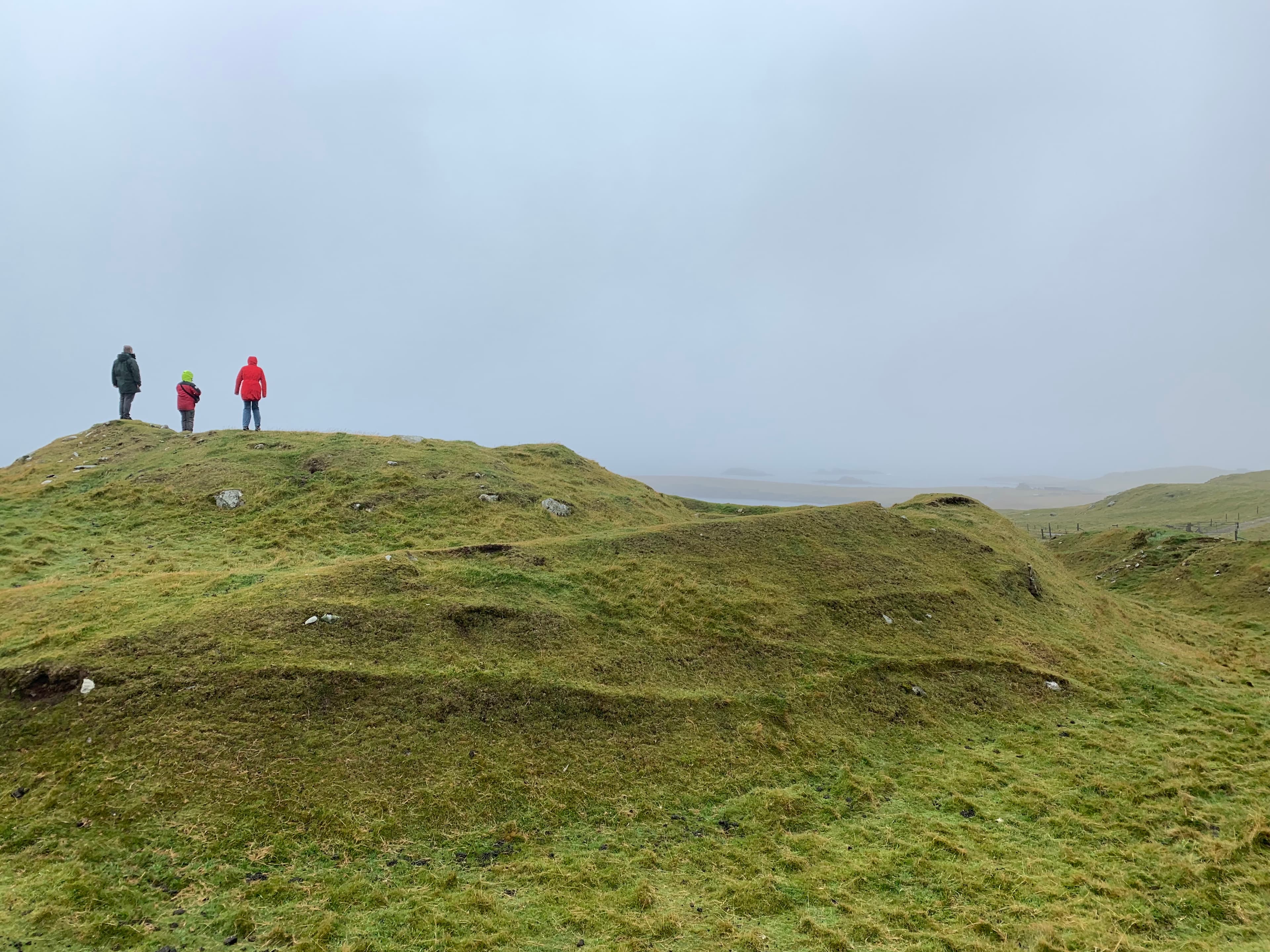
There is no car park, no ticket office, no interpretive centre at the site itself. You leave your vehicle on the minor road that runs along Unst's western coast and walk uphill through open pasture. Sheep may be grazing among the archaeological remains. The land is uneven, the grass rough, the wind likely persistent. Nothing mediates between you and the site.
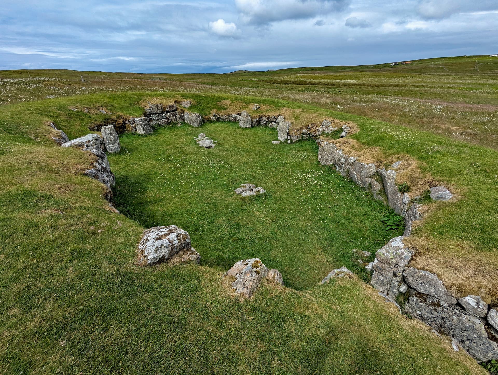
The broch occupies the highest point of the slope, approximately thirty-five metres above the bay. Two concentric defensive banks—earthen ramparts forming a D-shaped enclosure—are the most immediately visible features. They terminate at the edge of a steep drop to the west, where the ground falls away toward the sea. The broch itself, roughly seventeen metres across, sits within these banks. Its tower has long since collapsed, but the footprint remains, and the scale is evident. This was a substantial structure, built to be seen from the sea and from the surrounding landscape.
Descending the slope from the broch, you encounter the Norse longhouse sites. The walls of the Lower Underhoull longhouse, excavated by Alan Small in the 1960s, are still traceable though overgrown. The Upper Underhoull longhouse, excavated by the Viking Unst Project in 2007–2008, lies closer to the broch. These were not small dwellings. At approximately twenty-three metres long by five metres wide, each longhouse was a complete household unit: living space with a central hearth, areas for craft work and food preparation, and a byre at one end where livestock sheltered through the long Shetland winters.
The stone tells the story of continuity. The Norse builders used double-faced stone walls on the sea-facing southern side of their longhouses—the side visible to anyone approaching by water, built to impress. The northern back walls were turf-built for insulation against the prevailing weather. Some of this stone came directly from the broch above. You can trace this relationship in your mind if not always in the individual stones themselves: the same rock, quarried and shaped by Iron Age hands, repositioned by Norse hands a millennium later.
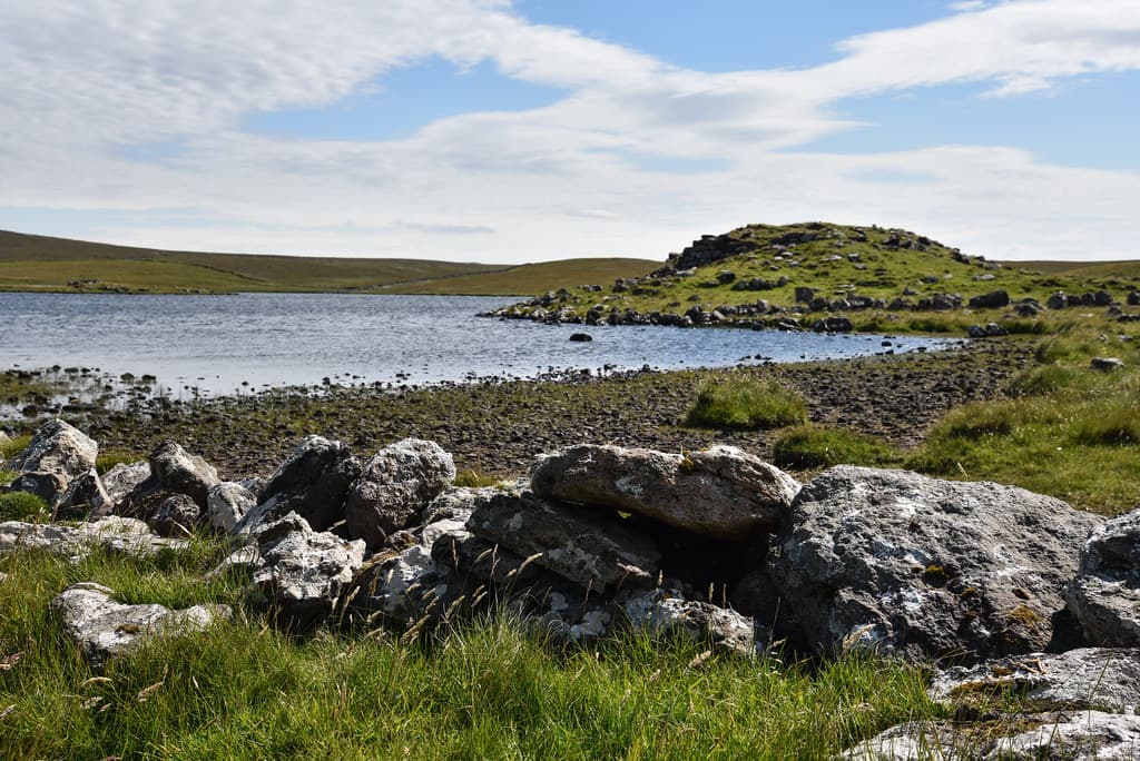
From the longhouse sites, the ground descends further to Lunda Wick. The bay is sheltered, its beach accessible, and the walk along the coast to St Olaf's Chapel at Lund takes perhaps twenty minutes. The chapel ruins are modest, but the churchyard contains four Viking-era stone crosses. One cross-slab probably dates to the tenth century—meaning it was carved within a generation or two of the Norse arrival on Unst. A lintel stone over one of the chapel windows bears a Pictish fish or serpent carving, an artefact from an even older tradition, reused in a Christian context. The walk from broch to longhouse to chapel traces a path through centuries.
The surrounding field systems are visible as low banks and lynchets across the hillside. Some may date to the Iron Age, others to the Norse period. They represent the agricultural infrastructure that sustained the settlement: the fields where barley was grown, the boundaries that defined grazing land, the patterns of cultivation that made life possible in this demanding landscape.
Underhoull lies on the western coast of Unst, overlooking Lunda Wick to the west and south. The broch occupies the highest point of the slope. The Norse longhouses descend the hillside below the broch toward the bay. St Olaf's Chapel at Lund lies approximately 500 metres south along the coast at the head of Lunda Wick. Bluemull Sound and the island of Yell are visible to the south.
Underhoull is understood primarily through its archaeology, which reveals a multi-period settlement spanning from the Early Iron Age to the medieval Norse period on the northernmost inhabited island in Britain.
Underhoull is recognised as a site of national importance for understanding both Iron Age broch culture and Norse settlement in Shetland. Alan Small's 1962–1966 excavation of the Lower Underhoull longhouse established three distinct occupation phases—Early Iron Age hut with souterrain, Iron Age broch, and Norse longhouse—making it a key comparator for the multi-period site at Jarlshof in southern Shetland. The Viking Unst Project (2005–2008) placed Underhoull within the broader context of Norse settlement on Unst, where the identification of over sixty longhouses represents an unparalleled density of Viking-era rural settlement. Radiocarbon dating of the Upper Underhoull longhouse confirmed construction in the period AD 880–1000 and abandonment by AD 1260–1380, providing the first secure Viking-period dates for a longhouse on Unst. The Scheduled Monument designation notes the site's inherent potential to advance understanding of the role and function of brochs, the relationship between brochs and other Iron Age settlement types, and the reuse of earlier sites by Norse settlers. The well-preserved field systems surrounding the site are recognised as rare and significant in a Scottish context, with high potential to illuminate agricultural practices across both the Iron Age and Norse periods.
No indigenous oral tradition specific to Underhoull has been recorded. The Pictish peoples who inhabited Shetland before the Norse arrival left few written records, and their oral traditions were largely supplanted by Norse culture. The place-name 'Underhoull' is itself of Norse origin, as is 'Lund' (from Old Norse 'lundr'), which may indicate a grove or sanctuary with pre-Christian Norse significance. The Norse naming of the landscape represents the imposition of one cultural framework upon another, older one. The Pictish fish or serpent carving found reused in St Olaf's Chapel at Lund is a rare surviving trace of pre-Norse symbolic culture in this landscape.
No significant esoteric or alternative spiritual interpretations have been specifically documented for Underhoull. The broader Shetland landscape, with its concentration of brochs, standing stones, and Norse settlements, attracts visitors interested in earth energies and the spiritual qualities of ancient sites. The remoteness and antiquity of the setting, combined with the near-continuous daylight of midsummer, contribute to a quality that some visitors interpret through a spiritual lens.
Several aspects of Underhoull remain unresolved. A rectangular structure adjacent to the broch's outer defensive bank has been speculatively identified as a possible Viking chapel but has never been excavated. The nature of the transition from Iron Age to Norse occupation—whether there was a gap, peaceful absorption, or displacement—is unknown. Why the Norse chose to build directly on and around the broch, rather than at a fresh site, may have been purely practical or may have involved deliberate association with the older structure's perceived authority. The full extent of the settlement complex has not been fully excavated, and undiscovered structures may lie beneath the pasture. The cause of abandonment in the thirteenth or fourteenth century remains undetermined.
Visit planning
Limited accommodation on Unst itself, primarily B&Bs and self-catering cottages. The Saxa Vord Resort at Haroldswick offers hotel-style accommodation. Booking in advance is strongly recommended during summer months. Wider accommodation options are available in Lerwick on the Shetland mainland, approximately 1.5 to 2 hours away including ferry crossings.
Respect the scheduled monument. Do not disturb stonework or ground. Close gates for livestock. Leave no trace.
Sturdy walking boots or shoes are essential for the uneven hillside terrain. Waterproof and windproof outer layers are necessary in all seasons. Shetland's maritime climate produces rapid weather changes, and the exposed coastal position of Underhoull intensifies wind chill. Layers are advisable.
Photography is permitted and the elevated position of the broch offers views across Lunda Wick and toward Yell. The low-angle light of Shetland's latitude is particularly striking in the hours around dawn and dusk, and during the simmer dim of midsummer.
No offerings are expected or traditional at this heritage site. Do not leave items at the monument.
It is illegal to damage, disturb, or carry out unauthorised works on the site. Do not climb on walls, remove stones, dig, or use metal detectors. The site is in open pasture, so be mindful of livestock and close gates.
Plan your visit
Address
Unnamed Road, Shetland ZE2 9DW, UK
Hours, fees, and access can change — verify on the official source before you travel. Practical details last checked Jun 2026.
Nearby sacred places
Sacred places within a half-day’s reach. Pilgrims often visit them together: walk one, stay for the other.
References
Sources consulted when researching this page. Independent verification by readers is welcome.
- 01Underhoull, broch, Iron Age and Norse farmsteads and field systems, North Isles, Shetland Islands — Ancient Monuments UKhigh-reliability
- 02Unst, Underhoull - Canmore (Site 28) — Historic Environment Scotland / Canmorehigh-reliability
- 03Underhoull, broch, Iron Age and Norse farmsteads and field systems (SM2087) — Historic Environment Scotlandhigh-reliability
- 04Underhoull Excavation — Shetland Amenity Trusthigh-reliability
- 05Excavations at Underhoull, Unst, Shetland — Alan Smallhigh-reliability
- 06Hamar and Underhoull, Unst: Settlement in Northernmost Scotland (Chapter 6) - The Viking Age in Scotland — Cambridge University Presshigh-reliability
- 07Viking Unst Project: Excavations at Hamar and The Upper House, Underhoull: Field Season 2007/2008 — Julie Bond et al. (NABO / University of Bradford)high-reliability
- 08Viking Unst — Shetland Amenity Trusthigh-reliability
- 09Trail 4 - Underhoull to Lund: a Viking World — Shetland Amenity Trust / Viking Unsthigh-reliability
- 10Unst, Shetland - Follow The Vikings — Follow The Vikings (Council of Europe Cultural Route)high-reliability
Key questions
What pilgrims usually ask
- Why is Underhoull Longhouse considered sacred?
- Explore Underhoull on Unst, Shetland: an Iron Age broch and Viking longhouse site spanning 2,000 years on Britain's northernmost inhabited island. Free access.
- What should I wear at Underhoull Longhouse?
- Sturdy walking boots or shoes are essential for the uneven hillside terrain. Waterproof and windproof outer layers are necessary in all seasons. Shetland's maritime climate produces rapid weather changes, and the exposed coastal position of Underhoull intensifies wind chill. Layers are advisable.
- Can I take photos at Underhoull Longhouse?
- Photography is permitted and the elevated position of the broch offers views across Lunda Wick and toward Yell. The low-angle light of Shetland's latitude is particularly striking in the hours around dawn and dusk, and during the simmer dim of midsummer.
- How long should I spend at Underhoull Longhouse?
- 1.5 to 2 hours including the broch, longhouses, and surrounding field systems
- What offerings are appropriate at Underhoull Longhouse?
- No offerings are expected or traditional at this heritage site. Do not leave items at the monument.
- What etiquette should visitors follow at Underhoull Longhouse?
- Respect the scheduled monument. Do not disturb stonework or ground. Close gates for livestock. Leave no trace.
- What is the history of Underhoull Longhouse?
- The first people to settle at Underhoull built a small hut and an underground storage chamber—a souterrain—during the Early Iron Age, perhaps in the mid-first millennium BC. The island of Unst would have been inhabited for millennia before this, but at Underhoull, this is where the archaeological record begins. The broch came later, part of a building tradition that swept across northern and western Scotland and the Northern Isles during the Iron Age. Over 130 brochs are known in Shetland alone—monumental circular towers of dry stone, some reaching fifteen metres in height, that combined domestic space with defensive capability and visible statements of power. The Underhoull broch was positioned at the top of a slope with commanding views. A working floor nearby produced evidence of iron smelting and stone vessel manufacture, indicating both domestic life and industrial production. The transformation came with the Norse. From the late ninth century, settlers from western Norway crossed the North Sea to Shetland. Unst, the northernmost of the inhabited islands, was likely among the first landfalls. The Norse did not merely pass through. They settled in extraordinary density: at least sixty longhouses have been identified across Unst, far exceeding the concentration found even in Scandinavia itself. At Underhoull, they built directly on and around the older broch, pulling its stone apart to construct their own dwellings. The Upper Underhoull longhouse was built between AD 880 and 1000 and occupied until roughly AD 1260–1380. Within it, excavators found soapstone vessels, spindle whorls, loom weights, pebble line-sinkers for fishing, and whetstones—the everyday objects of a farming and fishing household. The settlement's end is less well understood. The longhouse was abandoned in the thirteenth or fourteenth century. Whether this was driven by climate change, peat encroachment, economic shifts, or social pressures remains an open question. The site returned to pasture, and the ruins slowly disappeared beneath grass and soil until archaeology brought them back to light.
- Who is associated with Underhoull Longhouse?
- Alan Small, Dr Julie Bond, NABO (North Atlantic Biocultural Organization)