Stanydale Temple
Where Shetland's only megalithic building stands alone on open moorland, aligned to the turning of the year
Bixter, United Kingdom
Plan this visit
Practical context before you go
1.5 hours (including time to explore the surrounding prehistoric landscape)
Respect the Scheduled Ancient Monument status. Do not damage stonework. Do not remove materials. Leave no trace on the moorland.
At a glance
- Coordinates
- 60.2355, -1.4866
- Type
- Temple
- Suggested duration
- 1.5 hours (including time to explore the surrounding prehistoric landscape)
Pilgrim tips
- Waterproof boots or wellies are essential for the moorland walk. The approach crosses wet, boggy ground in all seasons. Warm, windproof, and waterproof layers are strongly recommended given Shetland's exposed and changeable weather. Temperatures can feel significantly colder than forecast due to persistent wind.
- Photography is freely permitted. The site is open-air and unattended. The surrounding landscape and sky offer dramatic backdrops. Dawn and dusk light, when accessible, can be particularly striking against the massive boulders.
- The moorland approach is wet and boggy in all seasons. Waterproof boots are essential. The terrain is uneven with tussocky grass and standing water. In poor visibility or low cloud, the site can be difficult to locate even with marker poles. There are no facilities, no shelter, and no mobile phone signal in many areas. Shetland weather can change rapidly. Carry waterproofs and warm layers regardless of the forecast. The stone walls are fragile despite their massive appearance. Do not climb on them or dislodge stones.
Overview
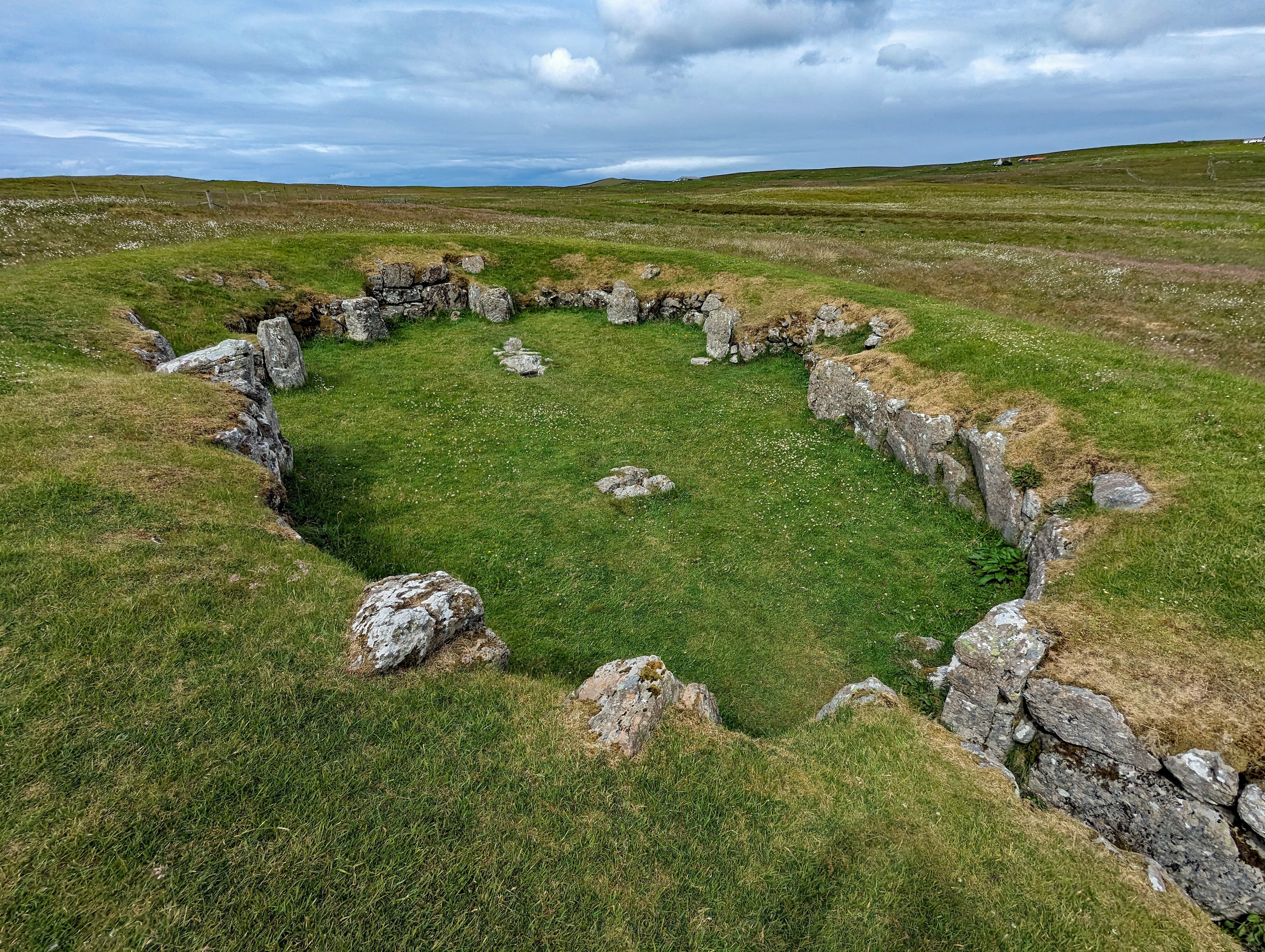
On a treeless hillside in western Shetland, a heel-shaped stone structure stands open to the sky. Built around 2500 to 2000 BC, Stanydale Temple is the largest and only truly megalithic building from prehistoric Shetland. Its massive boulder walls enclose an oval space with six recessed alcoves, entered through a narrow passage aligned almost precisely east-west. Two post-holes once held enormous spruce timbers carried by ocean currents from North America. A polished stone knife and burnt sheep bones found within suggest this was no ordinary dwelling.
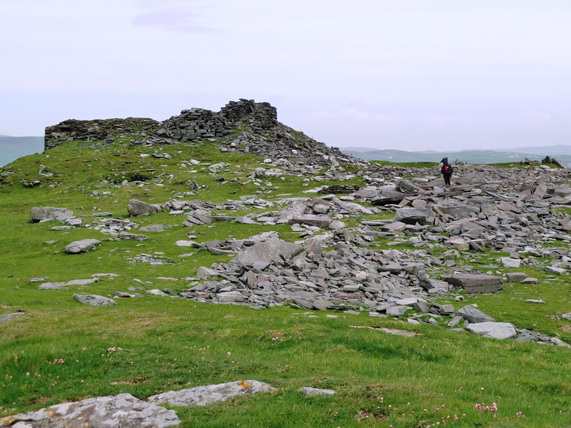
The walk prepares you. Fifteen minutes across open, boggy moorland with no path to speak of, only coloured marker poles and the wind. There is nothing between you and the sky. Then the stones appear: massive boulders arranged in a distinctive heel shape, their concave facade facing you as you approach from the east. This is Stanydale Temple, and even in ruin it commands the landscape.
The structure dates to approximately 2500 to 2000 BC, placing it in the late Neolithic or early Bronze Age. It is the largest building known from prehistoric Shetland and the only one constructed with truly megalithic stonework. The interior measures roughly 12 metres by 7 metres, with six shallow alcoves recessed into walls of extraordinary thickness. A single narrow entrance passage funnels movement along an east-west axis. Two post-holes in the floor once held spruce timber posts so massive they could only have arrived as driftwood from the forests of North America, carried across the Atlantic by ocean currents.
Charles Calder excavated the site in 1949 and named it a temple, drawing comparisons with the megalithic temples of Malta. That interpretation is now largely set aside. Modern scholars see the heel-shaped plan as a distinctly Shetland form, related to local traditions of heel-shaped cairns and tombs rather than Mediterranean imports. Whether the building served as a ceremonial centre, a chieftain's hall, or a communal meeting house remains genuinely uncertain. What is clear is that its construction required effort far exceeding any domestic need. The community that built Stanydale set this place apart, and the land around it still holds the traces of their daily life: field walls, smaller houses, clearance cairns arranged across roughly eight acres of enclosed ground.
Context and lineage
Around 2500 to 2000 BC, during the transition from the Neolithic to the Bronze Age, a community in western Shetland undertook a construction project unlike anything else in the islands. Using massive boulders, they built a heel-shaped structure with walls thick enough to stand for millennia. The interior, an oval large enough to hold a substantial gathering, was lined with six recessed alcoves. Two enormous spruce logs, carried by Atlantic currents from the forests of North America, were erected as roof supports. The roof itself was likely timber-framed and turf-covered, creating a dark, enclosed space entered through a single narrow passage aligned east-west.
The community that built the temple lived around it. A boundary wall enclosed roughly eight acres of land containing at least two smaller houses and some thirty clearance cairns, evidence of agricultural activity. The temple was the largest structure in this settlement by a significant margin, its construction effort implying a special communal purpose.
No written records survive from this period in Shetland. The site's story was recovered through excavation. In 1949, Charles S. T. Calder of the Royal Commission on the Ancient and Historical Monuments of Scotland excavated the structure. Inside, he found a polished stone implement he identified as a Shetland knife, a pile of burnt sheep bones, sherds of Beaker pottery, flat-based pot fragments, and the carbonised remains of the spruce timber posts. Calder was struck by the building's resemblance to the megalithic temples of Malta, particularly in its heel-shaped plan and monumental scale. He named it a temple.
The Maltese comparison proved controversial. Subsequent archaeologists pointed out that the heel-shaped form appears in various Shetland structures, including tombs and cairns, and likely represents a local architectural tradition rather than a Mediterranean import. The idea that Neolithic builders maintained cultural connections spanning the length of Europe was judged implausible by most scholars. Yet Calder's name endured. The building is still called Stanydale Temple, and the question of its purpose remains open.
Stanydale Temple belongs to a distinctive Shetland architectural tradition characterised by heel-shaped plans. This form appears in smaller domestic structures and in funerary cairns across the islands, suggesting a shared design vocabulary applied at different scales and for different purposes. The temple represents the grandest expression of this tradition, a communal building whose scale far exceeds any known dwelling from the same period. Its relationship to the broader Neolithic and Bronze Age cultures of Atlantic Europe is debated. The Beaker pottery found within connects the site to the Beaker cultural network that spread across western and central Europe during the late third and early second millennium BC, but the architectural form itself appears to be local. The use of driftwood spruce for structural timber places Stanydale within Shetland's long relationship with the Atlantic, where ocean currents have delivered materials from distant shores for as long as people have lived on the islands.
Charles S. T. Calder
Historic Environment Scotland
Why this place is sacred
The thinness at Stanydale is inseparable from the approach. There is no car park beside the structure, no interpretation panel at its doorway, no managed path. You walk across moorland that has changed remarkably little since the temple was built. The bog, the tussock grass, the standing water, the wind that never quite stops. By the time you reach the stones, the modern world has fallen away behind you. The only sounds are wind and, in season, the calls of curlew and snipe.
The structure itself creates a threshold. The narrow entrance passage channels you from the open moor into an enclosed interior, from sky to stone. The transition is deliberate. The builders chose a single point of entry aligned almost perfectly east-west, and two standing stones placed thirty-five metres from the doorway appear to mark the equinox sunrise. Twice a year, the turning of the seasons would have been visible from inside the building, sunlight entering along the passage axis. Whether this alignment was intentional remains debated, but the effect is real.
Within the oval interior, the six alcoves create intimate spaces within the larger enclosure. Standing in one, your back to stone, looking across a room that once rose to a driftwood-framed roof, you occupy a space that was designed to hold people in a particular arrangement. The architecture shapes behaviour even now, four and a half millennia later.
The surrounding landscape deepens the effect. The remains of two smaller houses lie nearby. A dry stone boundary wall encloses the field system. Clearance cairns mark where stones were gathered to prepare ground for cultivation. You are not visiting an isolated monument but standing within an entire community's world, one that was already ancient when the pyramids at Giza were young.
Perhaps the most haunting element is the driftwood. The two post-holes that held the roof supports contained carbonised remains of North American spruce. These timbers crossed the Atlantic on ocean currents before being found, recognised as valuable, and erected at the heart of the most important building in the community. The connection between this remote Shetland hillside and the forests of a continent its builders could never have imagined is a form of thinness in itself: a place where the boundaries of the known world were exceeded by the materials of construction.
Uncertain. The building's monumental scale far exceeds domestic architecture of its period. A polished stone knife interpreted as ritually significant and a pile of burnt sheep bones suggesting ceremonial offering or communal feasting were found during excavation. Calder proposed the structure was a temple; modern scholarship favours a communal hall, chieftain's hall, or ceremonial centre. The equinox alignment of the entrance passage may indicate seasonal gatherings connected to the solar calendar. The heel-shaped plan follows a Shetland architectural tradition shared with local tombs and cairns, which may suggest a connection between the forms used for the living and the dead.
The temple appears to have been occupied intermittently through into the early Iron Age, though the evidence for later use is limited. By the time Norse settlers reached Shetland around AD 800, the building had been abandoned for millennia. Calder's 1949 excavation brought the structure to scholarly attention, and his 'temple' designation has defined it in the public imagination despite being contested by subsequent archaeologists. The site was designated a Scheduled Ancient Monument (SM3314) and is now managed by Historic Environment Scotland with free, open access.
Traditions and practice
No specific rituals are documented in historical or ethnographic sources. The site was abandoned long before written records reached Shetland. Archaeological evidence suggests possible ceremonial practices: the burnt sheep bones may represent animal sacrifice, communal feasting, or both. The polished stone knife appears to have had a significance beyond the utilitarian. The equinox alignment of the entrance passage raises the possibility of seasonal ceremonies connected to the solar calendar, though this alignment has not been conclusively demonstrated as intentional. Beaker pottery fragments connect the site to the wider cultural networks of Bronze Age Europe, suggesting the community was not entirely isolated.
No active ceremonial practices take place at the site. It functions as an open-access archaeological monument. Some individuals visit at equinox to observe the potential solar alignment through the entrance passage, an informal practice rather than a structured tradition.
Begin by standing at the pedestrian gate before you start walking. Look across the moorland toward the temple site. The distance you are about to walk is the same distance the builders walked, over ground that has changed little. Let the approach be unhurried.
As you cross the moorland, notice the quality of silence between gusts of wind. Listen for curlew, snipe, and skylark in season. The soundscape is close to what the builders would have known, minus the sounds of their own voices and livestock.
When you reach the two standing stones east of the entrance, pause. These may have framed the equinox sunrise for the community. Whether or not they did, they mark a transition in the landscape, a threshold between the open moor and the approach to the structure.
Enter the passage slowly. Notice the change from open to enclosed, from sky to stone. The passage is deliberate in its narrowness. Inside, stand in the centre of the oval and turn slowly, taking in each of the six alcoves. Consider what arrangement of people this space was designed to hold. The architecture implies a gathering, a circle of participants facing inward.
Find one of the two post-holes. These depressions held spruce timbers that crossed the Atlantic as driftwood before being erected here. The builders recognised these logs as extraordinary materials and placed them at the heart of their most important building. The connection between ocean and interior, between distant forest and local stone, was built into the structure.
If conditions allow, sit within one of the alcoves. Feel the stone at your back. The wind will be partially blocked by the walls. From here, the interior space has a different character: intimate, sheltered, contained. Each alcove offers a slightly different perspective on the central space.
Before leaving, walk the surrounding landscape. Trace the boundary wall. Find the clearance cairns. Visit the smaller house foundations nearby. Understanding the temple as part of a living settlement, rather than as an isolated monument, changes its meaning.
Neolithic/Bronze Age Communal or Ceremonial
HistoricalStanydale Temple is the sole truly megalithic structure surviving from prehistoric Shetland and the largest building known from the Neolithic or Bronze Age period in the islands. Its monumental scale, which far exceeds any contemporary domestic dwelling, indicates a special communal purpose. The discovery of a polished stone knife and burnt sheep bones has been interpreted as evidence of ritual activity. The heel-shaped design follows a distinctly Shetland architectural tradition also seen in local tombs and cairns.
Uncertain. Possible ritual or ceremonial gatherings, communal meetings, or feasting. The burnt sheep bones and stone knife suggest some form of ceremonial offering. The entrance alignment with the equinox sunrise and sunset may indicate seasonal ceremonies connected to the solar calendar.
Archaeological and Conservation Stewardship
ActiveSince Calder's 1949 excavation, the site has been subject to scholarly study and heritage conservation. The Scheduled Ancient Monument designation (SM3314) provides legal protection, and Historic Environment Scotland manages public access. The site serves as a key reference point for understanding Neolithic and Bronze Age settlement in Shetland.
Archaeological research, heritage management, public interpretation through signage and walking route markers. The site is maintained as a freely accessible open-air monument.
Experience and perspectives
You begin at a small roadside parking area off a minor road south of the A971, roughly three miles southwest of Bixter. A signpost and pedestrian gate mark the start. Coloured poles guide you across the moorland, though the path itself is faint and in places barely distinguishable from the surrounding bog. Wear waterproof boots. The ground is wet in all seasons and deeply so from autumn through spring.
The walk takes about fifteen minutes and gains moderate elevation. As you climb, the view opens: west toward Gruting Voe and the Atlantic, east across the central mainland of Shetland. There are no trees. The sky is enormous. Wind is a near-constant companion, sometimes fierce enough to make standing difficult.
The temple announces itself gradually. The massive boulders of its walls emerge from the moorland as you approach from the east, and the distinctive concave facade becomes clear. Two standing stones, roughly one and a half metres tall, stand thirty-five metres from the entrance, marking the approach. These may have served as equinox markers, framing the sunrise along the passage axis in late March and September.
The entrance passage is narrow and low. Stepping through it, you cross from open sky into enclosed space. The walls are thick, built of boulders that would have required significant communal effort to place. The interior is an oval roughly twelve metres long and seven metres wide. Six shallow recesses are set into the walls, each about two and a half metres wide and just over a metre deep. These alcoves create distinct zones within the larger space. Two post-holes near the centre mark where the spruce roof supports once stood.
Stand in the centre and look up. The roof is gone. Sky fills the space where timber and turf once enclosed an interior that must have been impressive in its scale and darkness, lit perhaps by a central hearth, filled with the gathered community. The acoustics of the space, even roofless, suggest what it might have been like: voices carrying, sound contained by the thick stone walls.
After exploring the interior, walk the surrounding landscape. The remains of two smaller prehistoric houses stand nearby, and the dry stone field wall that enclosed the roughly eight-acre settlement can be traced along the hillside. Clearance cairns, where stones were piled to make land cultivable, dot the enclosed area. This was a working landscape, and the temple stood at its centre.
If you visit at equinox, arrive before dawn. Position yourself within the temple and watch the sunrise through the entrance passage. The experience has not been conclusively shown to be intentional, but the alignment is close enough that the sun enters along the passage axis, illuminating the interior. Whether or not the builders planned this, the phenomenon connects you to the astronomical cycles that governed their agricultural year.
Stanydale Temple stands on a hillside in western Mainland Shetland, approximately three miles southwest of Bixter. The entrance passage faces east. Two standing stones stand to the east of the entrance. The concave facade faces roughly east-southeast. The surrounding field system and house remains extend across the hillside to the north and south.
Stanydale Temple has generated scholarly debate since its excavation in 1949. The central question remains deceptively simple: what was this building for? Its monumental scale, ritual artefacts, and astronomical alignment have invited interpretations ranging from temple to community hall, and the answer likely lies somewhere in the spaces between these categories.
Scholarly opinion converges on several points while diverging on the fundamental question of function. There is broad agreement that Stanydale is unique in Shetland as the only truly megalithic structure and the largest known building from the Neolithic or Bronze Age period in the islands. The heel-shaped plan is recognised as a local Shetland tradition rather than a Mediterranean import, appearing in smaller domestic structures and funerary cairns across the islands. Calder's original comparison with Maltese temples, which led to the 'temple' designation, is largely rejected by modern archaeologists who find the Maltese parallel unpersuasive given the lack of evidence for long-distance cultural transmission.
However, scholars also agree that the building's monumental scale and the nature of the finds within it distinguish Stanydale from purely domestic architecture. The polished stone knife appears to have held special significance, and the pile of burnt sheep bones suggests some form of ceremonial activity, whether sacrificial offering, communal feasting, or both. The east-west alignment of the entrance passage is acknowledged but its astronomical intentionality remains unproven.
Current interpretation tends toward viewing Stanydale as a communal building of exceptional status whose function may have combined ceremonial, political, and social roles. The distinction between 'temple' and 'hall' may be anachronistic when applied to a society in which sacred and secular life were likely intertwined. The site's context within a broader landscape of houses, field systems, and cairns is considered essential for understanding its role in prehistoric Shetland settlement patterns.
Calder's 1949 excavation, reported in the Proceedings of the Society of Antiquaries of Scotland in 1950, remains the primary archaeological source. It predates modern excavation techniques, and scholars have noted that re-examination of the finds and stratigraphy using current methods would be valuable.
Some writers have emphasised the equinox alignment and proposed that Stanydale functioned as a solar temple with deliberate astronomical orientation, connecting it to broader traditions of Neolithic astronomical architecture across Atlantic Europe. Sites such as Newgrange in Ireland and Maeshowe in Orkney demonstrate that Neolithic builders were capable of precise solar alignments, and proponents argue Stanydale may belong to this tradition. The comparison with Maltese temples, though rejected by mainstream archaeology, continues to inspire speculation about long-distance cultural connections in the Neolithic period. These perspectives, while not supported by the current weight of evidence, reflect a genuine scholarly uncertainty about the capabilities and networks of Neolithic societies.
The central mystery remains: what was Stanydale Temple for? The archaeological evidence is suggestive but not conclusive. The burnt sheep bones could represent ritual sacrifice, communal feasting, or simply the remnants of meals. The polished stone knife may have been a ritual implement or a valued domestic tool. The equinox alignment may be intentional or coincidental. How the building's use changed over time and why it was eventually abandoned are unknown. The relationship between the temple and the surrounding settlement raises further questions: did it serve only the local community, or did it draw people from a wider area for seasonal or ceremonial gatherings? The identity, beliefs, and social organisation of its builders remain beyond the reach of current evidence. No written records, no oral traditions, and no pictorial representations survive from this period in Shetland.
Visit planning
The nearest accommodation is in Bixter or along the A971 corridor. Lerwick, 40 minutes by car, offers a full range of options from hotels and guesthouses to self-catering. Shetland's small size means the site can be visited as a day trip from anywhere on the mainland.
Respect the Scheduled Ancient Monument status. Do not damage stonework. Do not remove materials. Leave no trace on the moorland.
Waterproof boots or wellies are essential for the moorland walk. The approach crosses wet, boggy ground in all seasons. Warm, windproof, and waterproof layers are strongly recommended given Shetland's exposed and changeable weather. Temperatures can feel significantly colder than forecast due to persistent wind.
Photography is freely permitted. The site is open-air and unattended. The surrounding landscape and sky offer dramatic backdrops. Dawn and dusk light, when accessible, can be particularly striking against the massive boulders.
Not traditionally associated with offerings. Do not leave objects at the site. The most appropriate offering is attentive presence and careful treatment of the stones.
It is illegal to damage, disturb, or remove any material from the site. Do not climb on the boulder walls. Do not use metal detectors. Do not excavate or probe the ground. Respect the archaeological integrity of the surrounding landscape features including field walls, clearance cairns, and house foundations. No camping or fires.
Plan your visit
Address
Mainland, Shetland ZE2 9NR, UK
Hours
Hours, fees, and access can change — verify on the official source before you travel. Practical details last checked Jun 2026.
Nearby sacred places
Sacred places within a half-day’s reach. Pilgrims often visit them together: walk one, stay for the other.
References
Sources consulted when researching this page. Independent verification by readers is welcome.
- 01Stanydale 'Temple' — Historic Environment Scotlandhigh-reliability
- 02Stanydale 'Temple': History — Historic Environment Scotlandhigh-reliability
- 03In Depth - Stanydale — Archaeology Shetlandhigh-reliability
- 04Report on the Excavation of a Neolithic Temple at Stanydale in the Parish of Sandsting, Shetland — Charles S. T. Calder, Proceedings of the Society of Antiquaries of Scotlandhigh-reliability
- 05Stanydale Statement of Significance — Historic Environment Scotland Publicationshigh-reliability
- 06Stanydale Temple — Wikipedia
- 07Staneydale Temple Walk — Walkhighlands
- 08The Spring Equinox & a Neolithic Temple (Stanydale, Shetland) — Shetland With Laurie
- 09Stanydale Temple, Shetland, History & Visiting Information — Britain Express
- 10Stanydale - Wikidata — Wikidata
Key questions
What pilgrims usually ask
- Why is Stanydale Temple considered sacred?
- Visit Stanydale Temple, Shetland's only megalithic building from the Neolithic period. Free open access to a 4,500-year-old heel-shaped structure on remote moor
- What should I wear at Stanydale Temple?
- Waterproof boots or wellies are essential for the moorland walk. The approach crosses wet, boggy ground in all seasons. Warm, windproof, and waterproof layers are strongly recommended given Shetland's exposed and changeable weather. Temperatures can feel significantly colder than forecast due to persistent wind.
- Can I take photos at Stanydale Temple?
- Photography is freely permitted. The site is open-air and unattended. The surrounding landscape and sky offer dramatic backdrops. Dawn and dusk light, when accessible, can be particularly striking against the massive boulders.
- How long should I spend at Stanydale Temple?
- 1.5 hours (including time to explore the surrounding prehistoric landscape)
- What offerings are appropriate at Stanydale Temple?
- Not traditionally associated with offerings. Do not leave objects at the site. The most appropriate offering is attentive presence and careful treatment of the stones.
- What etiquette should visitors follow at Stanydale Temple?
- Respect the Scheduled Ancient Monument status. Do not damage stonework. Do not remove materials. Leave no trace on the moorland.
- What is the history of Stanydale Temple?
- Around 2500 to 2000 BC, during the transition from the Neolithic to the Bronze Age, a community in western Shetland undertook a construction project unlike anything else in the islands. Using massive boulders, they built a heel-shaped structure with walls thick enough to stand for millennia. The interior, an oval large enough to hold a substantial gathering, was lined with six recessed alcoves. Two enormous spruce logs, carried by Atlantic currents from the forests of North America, were erected as roof supports. The roof itself was likely timber-framed and turf-covered, creating a dark, enclosed space entered through a single narrow passage aligned east-west. The community that built the temple lived around it. A boundary wall enclosed roughly eight acres of land containing at least two smaller houses and some thirty clearance cairns, evidence of agricultural activity. The temple was the largest structure in this settlement by a significant margin, its construction effort implying a special communal purpose. No written records survive from this period in Shetland. The site's story was recovered through excavation. In 1949, Charles S. T. Calder of the Royal Commission on the Ancient and Historical Monuments of Scotland excavated the structure. Inside, he found a polished stone implement he identified as a Shetland knife, a pile of burnt sheep bones, sherds of Beaker pottery, flat-based pot fragments, and the carbonised remains of the spruce timber posts. Calder was struck by the building's resemblance to the megalithic temples of Malta, particularly in its heel-shaped plan and monumental scale. He named it a temple. The Maltese comparison proved controversial. Subsequent archaeologists pointed out that the heel-shaped form appears in various Shetland structures, including tombs and cairns, and likely represents a local architectural tradition rather than a Mediterranean import. The idea that Neolithic builders maintained cultural connections spanning the length of Europe was judged implausible by most scholars. Yet Calder's name endured. The building is still called Stanydale Temple, and the question of its purpose remains open.
- Who is associated with Stanydale Temple?
- Charles S. T. Calder, Historic Environment Scotland