Eshaness Broch
An Iron Age tower on a loch promontory where three defensive walls meet the volcanic edge of the North Atlantic
Hillswick, United Kingdom

Plan this visit
Practical context before you go
1 to 2 hours (broch exploration plus nearby cliff scenery and loch shore)
Respect the scheduled monument status. Do not disturb, damage, or remove any material. Leave no trace.
At a glance
- Coordinates
- 60.4955, -1.6123
- Type
- Broch
- Suggested duration
- 1 to 2 hours (broch exploration plus nearby cliff scenery and loch shore)
Pilgrim tips
- The exposed Eshaness location demands warm, windproof, and waterproof clothing at all times of year. Walking boots are essential—the ground between the car park and the broch is rough moorland, and the causeways and broch interior have uneven stone surfaces that can be slippery when wet. Bring layers even in summer; conditions can change rapidly at this latitude.
- Photography is freely permitted and the site is well suited to it. The broch with the loch as foreground and the Eshaness cliffs as background makes for striking compositions. Early morning and evening light at this latitude can be extraordinary, particularly during the summer simmer dim.
- The broch is an unmanaged ruin with no safety infrastructure. The causeways can be slippery when wet. Do not climb on unstable wall sections. The ground within and around the broch is uneven with fallen stonework. The nearby cliff edges are unfenced and dangerous, particularly in wind. There is no shelter anywhere in the area. Always check weather forecasts before setting out—Atlantic storms can develop rapidly and conditions on the exposed Eshaness headland can become severe with little warning.
Overview
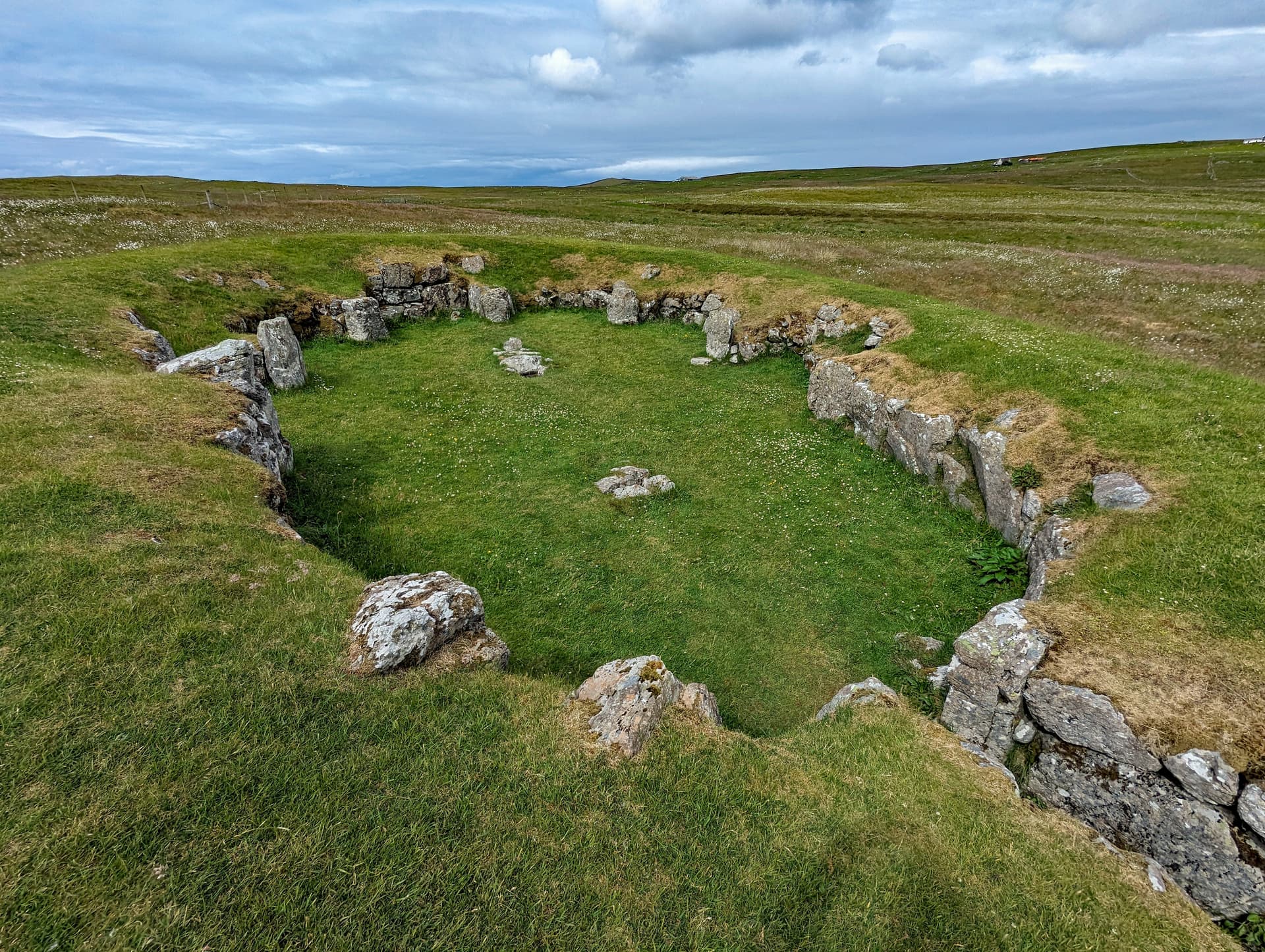
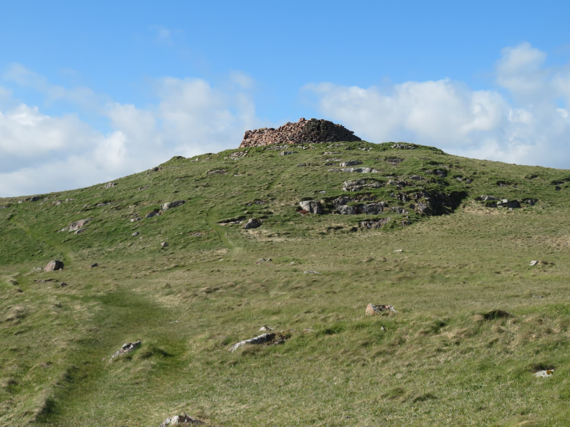
On a promontory in the Loch of Houlland, reached by stone causeways across the water, the Broch of Houlland rises to four metres against the sky of northwest Shetland. Three lines of defensive walling guard the approach. Half a mile to the west, the volcanic cliffs of Eshaness drop into the North Atlantic. The broch has stood here for two thousand years, its hollow walls still holding the dark chambers where Iron Age families sheltered from the same winds that batter the headland today.
The walk from the Eshaness Lighthouse car park takes fifteen minutes across open moorland. There is no signposted path for most of the route, no handrail, no ticket booth. You navigate by sight—the Loch of Houlland visible ahead, the broch's dark walls distinguishable from the surrounding rock only as you draw closer. This absence of mediation is part of what makes the Broch of Houlland remarkable. You encounter it on its own terms, within a landscape that has changed very little since the Iron Age.
The broch sits on a promontory extending into the freshwater loch, connected to the mainland by causeways that also link to a small islet. Three concentric lines of defensive walling cross the approach from the landward side, each one a threshold to be passed before reaching the tower itself. This layered defence—unusual in its elaboration for a Shetland broch—speaks of a site of considerable importance, a place worth protecting.
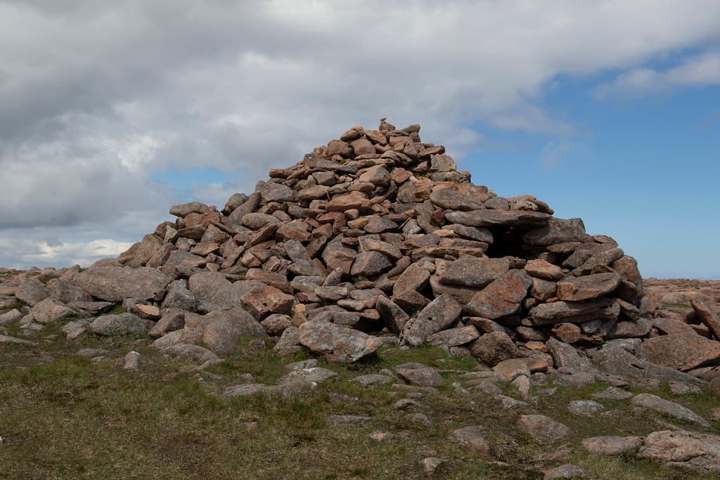
The tower walls survive to approximately four metres on the north and northeast sides. Within their thickness, you can still find mural cells—chambers built into the hollow walls—and traces of an internal staircase that once led to upper floors. The broch is one of roughly 120 recorded around the Shetland coastline, part of the Atlantic Scottish tradition of monumental dry-stone tower construction that flourished during the Iron Age. But its setting distinguishes it. The Eshaness peninsula sits on the remnants of a 395-million-year-old stratovolcano. The cliffs nearby are among the most powerful storm coastlines in the world. The builders of this broch chose to place their monument where geological deep time and human deep time converge—where the raw force of ocean meets the patience of stone laid by hand.
Context and lineage
Sometime during the first century BC or the first century AD—the precise date remains uncertain in the absence of comprehensive excavation—a community in northwest Shetland undertook a considerable feat of construction. They chose a promontory in the Loch of Houlland, a freshwater loch in the Eshaness area of the Northmavine peninsula, and built a broch: a circular dry-stone tower with walls thick enough to contain internal chambers and a staircase.
The builders belonged to the Atlantic Scottish broch-building tradition, a cultural phenomenon unique to Scotland and concentrated in the Northern and Western Isles, Caithness, and Sutherland. Across this region, communities raised hundreds of these towers during the Iron Age—over 500 are known across Scotland, with approximately 120 in Shetland alone. The towers served as defensive dwellings, statements of power, and focal points for local settlement.
At Houlland, the builders went further than many. They constructed three concentric lines of defensive walling across the landward approach to the promontory—an unusual elaboration that suggests a site of particular importance. They built causeways across the loch, linking the promontory to an islet and from there back to the shore. The controlled approach—across water, through walls, into the tower—created a layered progression from the outside world to the inner sanctum.
The identity of the builders is unknown. No written records exist from Iron Age Shetland. They were likely a chieftain's community with access to the significant labour resources required for such construction. They chose a location of extraordinary natural drama—the volcanic headland of Eshaness, where the North Atlantic meets ancient volcanic rock—and placed their monument within it.
The Broch of Houlland belongs to the Atlantic Scottish broch tradition, the same building culture that produced the famous Broch of Mousa (the best-preserved broch in Scotland, retaining its full height), the Broch of Clickimin in Lerwick, and hundreds of other tower structures across Scotland's north and west. Within the Eshaness area alone, at least three brochs have been recorded—Houlland, Sae Breck (half a mile to the south), and a third—suggesting a density of Iron Age settlement that raises questions about territorial organisation in this part of Shetland. The loch-promontory setting with causeway access follows a pattern shared with the Broch of Clickimin, one of the most extensively studied broch sites in the islands.
George Low
Stephen Jennings
Why this place is sacred
The thinness of the Broch of Houlland operates through accumulation. Each element of the approach strips away another layer of the ordinary world.
First, the drive. You leave the A970, Shetland's main spine road, and travel northwest through Hillswick into the Northmavine peninsula—the most remote part of mainland Shetland. The road narrows to single track. Settlement thins. The landscape opens into windswept moorland and exposed volcanic coastline. By the time you reach the Eshaness Lighthouse car park, you are already at an edge.
Then the walk. No formal path, just open moorland between you and the loch. The ground is rough, the sky is wide, and the sound of the sea carries from the cliffs to the west. The Loch of Houlland appears ahead, dark water in a basin of low hills.
Then the causeways. Stone paths crossing the water to the promontory. You are no longer on the mainland. You walk above the surface of the loch, between land and water, in that liminal space that cultures across the world have associated with passage between states of being.
Then the walls. Three lines of defensive walling, each one a gate to be passed through. The builders intended this sequential narrowing—from open landscape to enclosed approach to defended interior. Whether the intent was purely military or carried ceremonial overtones, the effect on the modern visitor is the same: by the time you stand within the broch itself, you have crossed multiple boundaries.
The volcanic geology adds a deeper register. The rocks beneath your feet formed 395 million years ago, when this land was part of a stratovolcano. The broch was built two thousand years ago. You stand here now. Three timescales, one place. The broch exists at the intersection of geological time, archaeological time, and the present moment—and in that convergence, ordinary perception shifts.
The remoteness completes it. On most days, you will be the only person here. The wind, the water, the dark stone walls, the silence between gusts—these are the conditions in which the site speaks most clearly.
The broch served as a defensive dwelling—likely the seat of a local chieftain and the focal point of an Iron Age community. The elaborate defences suggest a site of high status. The loch-promontory setting, with causeways as the only approach, echoes other prestigious Shetland brochs such as Clickimin, where the controlled access appears to have carried both practical and symbolic significance.
After the broch's primary period of use, smaller oval and sub-rectangular structures were built on the southwest side and the landward approach, suggesting continued occupation or reuse in a diminished form. The broch walls gradually collapsed and the site returned to the landscape. George Low visited in 1774 and removed stones to examine the construction technique, confirming dry-stone building without mortar. A partial excavation in 1998 opened two trenches on the summit, though detailed results have not been widely published. A 3D model derived from kite aerial photography was created in 2014. The site received scheduled ancient monument protection, which was later extended to cover the loch bed around the causeways—acknowledging the likelihood of further submerged archaeological remains.
Traditions and practice
No specific rituals or ceremonies are documented for the Broch of Houlland. As the seat of a local chieftain, the broch would have been the focal point for community gatherings, feasting, and decision-making during the Iron Age. The elaborate defensive architecture—three walls, causeway access, controlled entrance—suggests formal protocols of approach that may have held social or ceremonial significance beyond their military function. The broch would have housed a chieftain's family and retainers, with the surrounding walled enclosures providing space for livestock, storage, and subsidiary dwellings.
No active ceremonial practices take place at the site. The broch is an unmanaged archaeological ruin visited primarily by walkers exploring the Eshaness coastline. It forms part of the Eshaness Circular walk, a roughly six-kilometre route that incorporates the broch, the volcanic cliffs, the Grind o' da Navir storm beach, and the wider geological landscape.
Begin at the Eshaness Lighthouse car park and read the information panel to orient yourself within the wider landscape. Walk across the moorland toward the Loch of Houlland, allowing the gradual approach to shift your attention from the modern world to the ancient one.
Cross the causeways slowly. Notice the water on either side, the sensation of moving between land and water. The builders intended this crossing to mark a transition, and it still does.
Pass through the defensive walls one at a time. Pause at each. Consider the labour required to build them, the community that lifted and placed each stone. The three walls create a sequence of thresholds—honour that intention by moving through them with awareness.
Inside the broch, place your hand on the wall. The stones are cold, rough, precisely fitted without mortar. Within the wall thickness, find the mural cells. Step inside one if you can do so safely. Let your eyes adjust to the darkness. These small chambers held lives—stores, warmth, sleep. The intimacy of the space contrasts with the vastness of the landscape outside.
Sit within the broch and face west, toward the Eshaness cliffs. Let the two scales of the landscape settle into relation: the human-built enclosure around you, the geological immensity beyond. The broch was placed here deliberately, at this meeting point. The contemplative value of the site lies in inhabiting that juxtaposition.
If conditions allow, walk to the cliff edge after visiting the broch and look back toward the loch. From this vantage, the broch becomes a small dark form beside the water—a human mark on a landscape shaped by volcanic eruption and oceanic erosion. The shift in perspective completes the experience.
Iron Age Broch Culture
HistoricalThe Broch of Houlland is one of approximately 120 brochs recorded around the coast of Shetland, and one of at least three in the Eshaness area. Brochs were monumental dry-stone towers unique to Atlantic Scotland, built during the Iron Age as defensive dwellings, expressions of power, and focal points for local communities. The Houlland broch's elaborate three-walled defences and loch-promontory setting with causeway access indicate a site of considerable importance within this tradition.
Defensive habitation, agricultural and fishing subsistence, communal gathering. The broch would have housed a chieftain's family and retainers, with surrounding enclosures providing space for livestock, storage, and subsidiary dwellings. The controlled approach through multiple defensive walls may have carried ceremonial as well as military significance.
Shetland Trow Folklore
HistoricalAcross Shetland, broch ruins were associated with trows—supernatural beings in the islands' Norse-influenced folklore. Trows were believed to be small, nocturnal creatures inhabiting hills and ancient structures. While no specific trow legend is documented for the Broch of Houlland, the broader folk tradition connecting broch ruins with otherworldly inhabitants would have shaped how local communities related to the site across the centuries.
Traditions of avoidance or wary respect toward broch ruins, folk beliefs about supernatural inhabitants of ancient structures.
Experience and perspectives
Begin at the Eshaness Lighthouse car park. An information panel here provides context for the wider Eshaness landscape, including the broch. Take a moment to orient yourself. The lighthouse stands at the cliff edge to the west. The Loch of Houlland lies to the northeast, and the broch—though not immediately visible at this distance—occupies its southern promontory.
The walk crosses open moorland. There is no formal path for most of the route, so wear walking boots and be prepared for wet, uneven ground. As you approach the loch, the broch resolves from the surrounding landscape—dark stone walls on a low promontory, distinguishable from natural rock formations by their regularity and height.
The causeways are the threshold. Stone paths extend from the shore across the water to the promontory, with a smaller route connecting to an islet in the loch. Crossing them, you feel the shift. The water is on either side. The mainland falls behind. You are walking to a place that was deliberately set apart from the surrounding land.
The three lines of defensive walling become apparent as you approach from the landward side. An entrance passage cuts through the outer two walls. Each wall marks a further degree of enclosure, a narrowing of the approach. By the time you reach the broch itself, you have passed through a carefully designed sequence of barriers.
The tower walls on the north and northeast sides still stand to roughly four metres—high enough to create a genuine sense of enclosure when you step inside. The wall thickness is substantial, and within it you can find the mural cells: chambers built into the hollow walls that once served as storage spaces, guard rooms, or sleeping quarters. Traces of an internal staircase are visible, evidence of the upper floors that once made this a multi-storey dwelling.
Stand inside and look up. The walls frame the sky. Two thousand years ago, this opening would have been crossed by wooden floors, the space above closed into rooms. Smoke from a central hearth would have risen through the structure. Voices would have carried off the stone. Now there is only sky and wind and the sound of water from the loch below.
From the broch, look west toward the Eshaness cliffs. On a clear day, the sea stacks and cliff formations are visible—the volcanic architecture of a landscape shaped by forces that dwarf human timescales. The juxtaposition is what makes this site singular: the intimate, hand-built scale of the broch against the vast geological drama of the Eshaness coast.
If time allows, explore the subsidiary structures on the southwest side and the landward approach. These smaller buildings—oval and sub-rectangular in plan—date from after the broch's primary use and tell a story of continued habitation in diminished circumstances, of people still choosing to live beside the great tower even after it had begun to fall.
The Broch of Houlland occupies a promontory extending into the Loch of Houlland from its southern shore. The Eshaness Lighthouse car park lies approximately one kilometre to the southwest. The causeways approach from the south and connect to a small islet to the northwest. The three defensive walls cross the landward approach from the south. The volcanic cliffs of Eshaness lie roughly half a mile to the west.
The Broch of Houlland is understood primarily through archaeological survey and limited excavation, set within the broader scholarly understanding of Atlantic Scotland's broch-building tradition.
The Broch of Houlland is recognised as one of the more impressive unexcavated brochs in Shetland. Its significance rests on several features: the defensive complexity of three concentric outer walls (unusual for a Shetland broch), the loch-promontory location with causeway access (a pattern shared with the higher-profile Broch of Clickimin), and the survival of walls to approximately four metres with visible mural cells and staircase traces.
The broch belongs to the broader Atlantic Scottish broch tradition that flourished during the Iron Age, roughly from the first century BC to the second century AD. Unlike the majority of Shetland brochs, which sit close to the coastal edge, the Houlland broch is positioned 400 to 500 metres inland on a freshwater loch, a distinction that may reflect different defensive priorities or status considerations.
The construction demonstrates the characteristic hollow-wall technique: two concentric stone skins with the space between them divided into chambers (mural cells) and containing a staircase for access to upper levels. The three lines of outer walling, each with entrance passages, represent a significant investment of labour and suggest a site of considerable local importance.
The later subsidiary structures—small oval and sub-rectangular buildings on the southwest side and the landward approach—are probably post-broch but may still be prehistoric. They suggest continued occupation of the site after the tower itself ceased to function as a broch. The scheduled monument area was extended to include the loch bed around the causeways, recognising the archaeological potential of submerged remains.
No indigenous oral traditions specific to the Broch of Houlland have been recorded. However, across Shetland, broch ruins were traditionally associated with trows—trolls or fairies in Shetland's Norse-influenced folklore. Trows were believed to be small, nocturnal beings who inhabited hills and ancient ruins. While no specific trow legend is attached to the Houlland broch, the general folk association between broch ruins and supernatural beings would likely have applied to this site in the imagination of the surrounding Northmavine communities. The name 'Villians of Ure,' which appears in some records for the site, may itself carry folkloric associations, though its etymology is not clearly established.
No documented alternative or esoteric interpretations specific to this site have been identified. The broader broch tradition has attracted some speculation about astronomical alignments and ritual functions, but no such claims have been made for the Houlland broch specifically.
The broch has never been fully excavated, and substantial questions remain unanswered. The complete construction history, the sequence and dating of the different building phases, and the circumstances of the broch's abandonment are all unknown. The 1998 partial excavation opened two trenches on the summit, but detailed results have not been widely published.
The purpose of the two causeways and the small islet they connect remains unclear. They may have served defensive purposes (controlling approach routes), practical functions (fishing, water access), or symbolic ones (creating a processional route). The relationship between the three brochs recorded in the Eshaness area—Houlland, Sae Breck, and a third—raises unresolved questions about contemporary occupation, territorial boundaries, and the density of Iron Age settlement in this corner of Shetland. The extent of submerged or buried structures in the loch bed around the broch is unknown, though the extension of scheduled monument protection to cover this area suggests archaeological authorities consider the potential significant.
Visit planning
The nearest accommodation is in Hillswick (6 miles) or Brae (15 miles). Lerwick offers a full range of hotels, B&Bs, and self-catering accommodation. The remoteness of Eshaness means most visitors combine the broch with a day trip from Lerwick or a stay in the Northmavine area. There is a small campsite at Braewick, approximately 3 miles from Eshaness.
Respect the scheduled monument status. Do not disturb, damage, or remove any material. Leave no trace.
The exposed Eshaness location demands warm, windproof, and waterproof clothing at all times of year. Walking boots are essential—the ground between the car park and the broch is rough moorland, and the causeways and broch interior have uneven stone surfaces that can be slippery when wet. Bring layers even in summer; conditions can change rapidly at this latitude.
Photography is freely permitted and the site is well suited to it. The broch with the loch as foreground and the Eshaness cliffs as background makes for striking compositions. Early morning and evening light at this latitude can be extraordinary, particularly during the summer simmer dim.
Not traditionally associated with offerings. Do not leave any materials at the site.
As a scheduled ancient monument, it is illegal to disturb, damage, dig, or remove any material from the site. Do not climb on unstable wall sections. Respect the archaeological integrity of all structures including the outer defensive walls, causeways, and subsidiary buildings. No fires, no camping, no metal detecting.
Plan your visit
Address
Shetland ZE2 9RS, UK
Hours, fees, and access can change — verify on the official source before you travel. Practical details last checked Jun 2026.
Nearby sacred places
Sacred places within a half-day’s reach. Pilgrims often visit them together: walk one, stay for the other.
References
Sources consulted when researching this page. Independent verification by readers is welcome.
- 01Loch of Houlland, broch, Villians of Ure — Ancient Monuments UKhigh-reliability
- 02Loch Of Houlland, Esha Ness — Canmore (RCAHMS)high-reliability
- 03Site in Focus - An Eshaness Archaeology Circular — Archaeology Shetland (Stephen Jennings)high-reliability
- 04Off the Beaten Track 18 - Eshaness — Shetland Amenity Trusthigh-reliability
- 05Off the Beaten Track 11 - In search of Brochs — Shetland Amenity Trusthigh-reliability
- 06Eshaness Coast, Shetland — Scottish Geology Trusthigh-reliability
- 07Loch of Houlland Broch — The Megalithic Portal
- 08Eshaness Circular Walk — Shetland.org
- 09Eshaness Heritage Page — Shetland Heritage
- 10Esha Ness — Wikipedia
Key questions
What pilgrims usually ask
- Why is Eshaness Broch considered sacred?
- Visit the Broch of Houlland at Eshaness, Shetland. An Iron Age broch on a loch promontory near volcanic cliffs, with three defensive walls and causeway access.
- What should I wear at Eshaness Broch?
- The exposed Eshaness location demands warm, windproof, and waterproof clothing at all times of year. Walking boots are essential—the ground between the car park and the broch is rough moorland, and the causeways and broch interior have uneven stone surfaces that can be slippery when wet. Bring layers even in summer; conditions can change rapidly at this latitude.
- Can I take photos at Eshaness Broch?
- Photography is freely permitted and the site is well suited to it. The broch with the loch as foreground and the Eshaness cliffs as background makes for striking compositions. Early morning and evening light at this latitude can be extraordinary, particularly during the summer simmer dim.
- How long should I spend at Eshaness Broch?
- 1 to 2 hours (broch exploration plus nearby cliff scenery and loch shore)
- What offerings are appropriate at Eshaness Broch?
- Not traditionally associated with offerings. Do not leave any materials at the site.
- What etiquette should visitors follow at Eshaness Broch?
- Respect the scheduled monument status. Do not disturb, damage, or remove any material. Leave no trace.
- What is the history of Eshaness Broch?
- Sometime during the first century BC or the first century AD—the precise date remains uncertain in the absence of comprehensive excavation—a community in northwest Shetland undertook a considerable feat of construction. They chose a promontory in the Loch of Houlland, a freshwater loch in the Eshaness area of the Northmavine peninsula, and built a broch: a circular dry-stone tower with walls thick enough to contain internal chambers and a staircase. The builders belonged to the Atlantic Scottish broch-building tradition, a cultural phenomenon unique to Scotland and concentrated in the Northern and Western Isles, Caithness, and Sutherland. Across this region, communities raised hundreds of these towers during the Iron Age—over 500 are known across Scotland, with approximately 120 in Shetland alone. The towers served as defensive dwellings, statements of power, and focal points for local settlement. At Houlland, the builders went further than many. They constructed three concentric lines of defensive walling across the landward approach to the promontory—an unusual elaboration that suggests a site of particular importance. They built causeways across the loch, linking the promontory to an islet and from there back to the shore. The controlled approach—across water, through walls, into the tower—created a layered progression from the outside world to the inner sanctum. The identity of the builders is unknown. No written records exist from Iron Age Shetland. They were likely a chieftain's community with access to the significant labour resources required for such construction. They chose a location of extraordinary natural drama—the volcanic headland of Eshaness, where the North Atlantic meets ancient volcanic rock—and placed their monument within it.
- Who is associated with Eshaness Broch?
- George Low, Stephen Jennings