Lund Standing Stone
Shetland's largest standing stone, five millennia of silence on the edge of the inhabited world
Baltasound, United Kingdom
Plan this visit
Practical context before you go
45 minutes to 1 hour to examine both stones, the cairn remains, and absorb the landscape setting
Respect the scheduled monument status. Do not climb, dig, or disturb. Leave nothing but footprints on the grass.
At a glance
- Coordinates
- 60.7090, -0.9416
- Type
- Standing Stone
- Suggested duration
- 45 minutes to 1 hour to examine both stones, the cairn remains, and absorb the landscape setting
Pilgrim tips
- Shetland weather requires warm, waterproof, windproof layers in all seasons. Summer temperatures rarely exceed 15 degrees Celsius, and wind chill can reduce perceived temperature significantly. Sturdy, waterproof footwear is essential if you plan to walk to the cairn or the Burragarth stone across boggy moorland.
- Photography is freely permitted. The stone photographs well from all angles. The flat western face and the rounded eastern face offer contrasting perspectives. Morning and evening light at this latitude are particularly atmospheric, with long shadows and golden tones. The stone's scale is best conveyed by including a human figure for reference.
- The moorland between Bordastubble and Burragarth is trackless, often waterlogged, and fully exposed to wind. Appropriate footwear and clothing are essential. There are no facilities at the site. Mobile phone signal on Unst can be unreliable. If crossing to the Burragarth stone, inform someone of your plans.
Overview
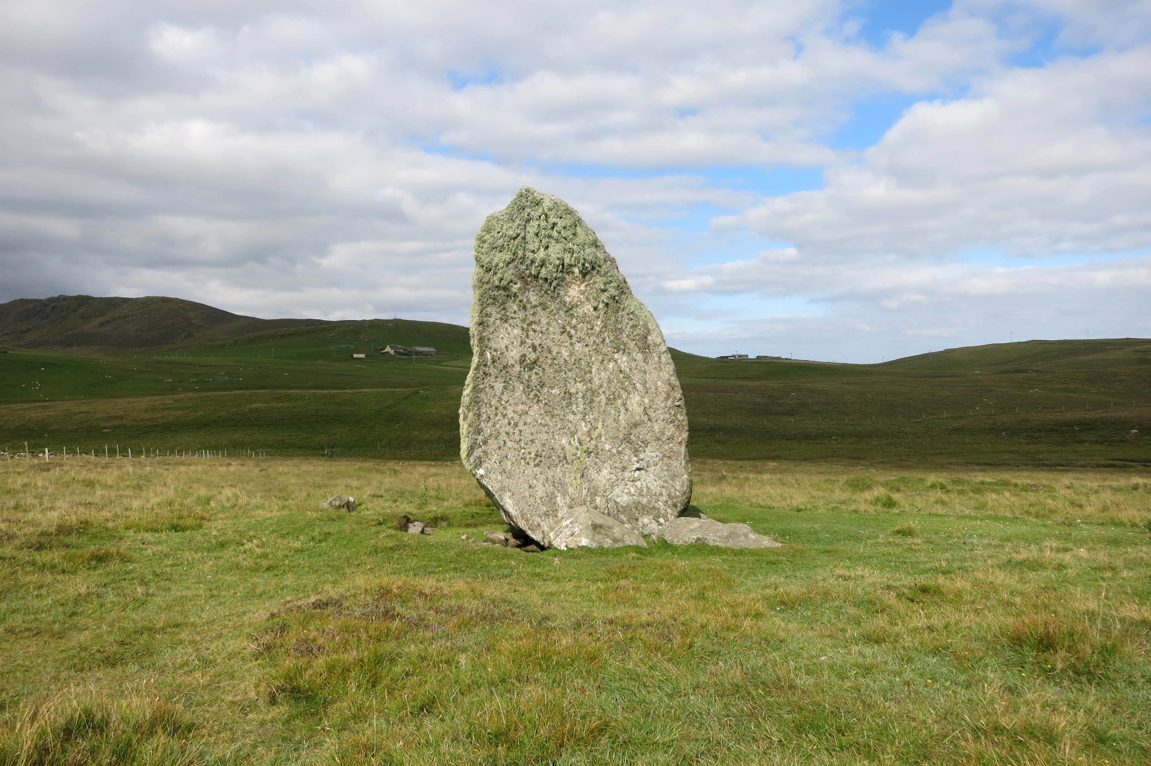
On the low moorland of southwest Unst, the most northerly inhabited island in the British Isles, a massive gneiss boulder stands roughly 3.8 metres tall with a girth approaching seven metres. The Lund Standing Stone, also called Bordastubble, has occupied this ground for over five thousand years. Paired with a companion stone to the north-northwest, it marks a lunar alignment across the open landscape. Sheep shelter against its base. The wind has not stopped since the Neolithic.
You arrive at the edge. Two ferry crossings from the Shetland mainland bring you to Unst, and from the Belmont terminal a minor road leads west toward Lund, where the land flattens into moorland and the Atlantic becomes audible. The stone appears beside the road without ceremony. There is no visitor centre, no interpretive panel demanding your attention, no barrier between you and a boulder that Neolithic hands chose to incorporate into their understanding of the world.
The Bordastubble Standing Stone is the largest in Shetland. Its gneiss mass may have been deposited here by retreating glaciers and subsequently adopted by the communities who found it, or it may have been dragged and raised by collective effort. Either way, packing stones at its base confirm deliberate human intention. This was not an accident of geology left undisturbed. It was claimed.
A second, smaller stone stands nearby within the remains of a cairn. Approximately 700 metres to the north-northwest, the Burragarth Standing Stone creates a paired sightline with a calculated lunar declination of 28.629 degrees. The alignment suggests these stones were not isolated markers but components of a landscape designed to track celestial movement. Earth and sky were read together here.
The surrounding land holds layer upon layer of subsequent habitation: an Iron Age broch at Underhoull, Norse longhouses at Lunda Wick, the medieval St Olaf's Chapel with its cross-carved gravestones. Each culture that settled this corner of Unst found the stone already standing, already ancient. The sheep who press against it for shelter from the wind have given it the local name Mam. The stone shelters what comes to it. It has been doing so for five thousand years.
Context and lineage
Around 3400 BC, during the Neolithic period, the communities living on Unst incorporated a massive gneiss boulder into their ritual landscape. The stone may have already been present, deposited by retreating glaciers at the end of the last ice age, or it may have been transported to this location by collective human effort, though its enormous weight makes the former more likely. Either way, the packing stones at its base confirm that it was deliberately stabilised and claimed as a monument.
The stone was not erected in isolation. A second, smaller stone was positioned nearby, surrounded by a cairn that may have served funerary or commemorative purposes. Approximately 700 metres to the north-northwest, the Burragarth Standing Stone was placed to create a paired sightline with a lunar declination of 28.629 degrees. This alignment follows the methodology documented by Alexander Thom across megalithic sites in Scotland, though it has not been independently verified through modern survey. If the alignment is intentional, it indicates that the Neolithic communities of Unst possessed sophisticated astronomical knowledge and embedded their observations in the physical landscape.
The broader context supports this interpretation. Shetland's Neolithic period produced numerous standing stones and stone circles, including the Hjaltadans circle on neighbouring Fetlar and the Standing Stones of Yoxie on Whalsay. These monuments were not random placements but deliberate interventions in the landscape, markers of meaning whose precise significance has been lost but whose physical presence endures.
In subsequent millennia, the land around the stone attracted successive waves of settlement. An Iron Age community built the Underhoull Broch overlooking Lunda Wick. Norse settlers established longhouses and a boat-shaped grave at Lunda Wick. A medieval chapel dedicated to St Olaf was built at Lund. Each culture found the stone already standing, already ancient, already part of the landscape's identity.
The Lund Standing Stone belongs to the Neolithic megalithic tradition that produced standing stones, stone circles, and cairns across Scotland and the Northern Isles from approximately 4000 to 2000 BC. In Shetland, this tradition is represented by sites including the Hjaltadans stone circle on Fetlar, the Standing Stones of Yoxie on Whalsay, and numerous individual menhirs across the islands. The Bordastubble stone's particular significance lies in its size, its paired lunar alignment with the Burragarth stone, and its position within a multi-period landscape that demonstrates continuous human engagement with this corner of Unst across five thousand years.
Alexander Thom
Historic Environment Scotland
RCAHMS / Canmore
Why this place is sacred
The thinness of this place operates through accumulation and exposure. Unst is the last inhabited island before the open North Atlantic. Beyond it lies only the lighthouse rock of Muckle Flugga and then nothing until the Arctic. To stand beside this stone is to stand at a genuine edge, a place where the human world narrows to a point before the sea takes over.
The stone itself compounds this quality. Five thousand years of wind, rain, salt, and frost have not moved it. Its surface carries the texture of deep time, the gneiss formed hundreds of millions of years before humans existed, then shaped by glaciers, then found and claimed by Neolithic peoples who recognised something in it worth marking. To touch it is to place your hand on a chain of geological and human time that extends beyond comprehension in both directions.
The lunar alignment adds a vertical dimension to this horizontal edge. The Bordastubble and Burragarth stones create a sightline that connects the moorland to the moon's path across the sky. Every 18.6 years, during the major lunar standstill, the moon reaches its most extreme position on the horizon, and the alignment between these two stones frames that moment. The people who established this connection were watching the sky with an attention we can only approximate. They built their observations into the land itself.
The layered archaeological landscape intensifies the sense of temporal permeability. Within walking distance of the stone, you can move from the Neolithic through the Iron Age, through the Norse period, through medieval Christianity. Each layer is visible, each transition legible. The stone presides over all of them, older than any, unmoved while cultures rose and dissolved around it.
The wind is constant. It strips away the insulation of comfort and familiarity. Standing beside the Bordastubble stone in a Shetland gale, you are reduced to essentials: stone, wind, sky, the distant sound of the sea. The barriers between you and the elemental world become very thin indeed.
The stone was likely erected or intentionally positioned during the Neolithic period, estimated at approximately 3400 BC. Its pairing with the Burragarth stone in a lunar alignment suggests astronomical observation or the ceremonial marking of lunar cycles. The cairn associated with the smaller southern stone implies funerary or commemorative practices. The monument appears to have functioned as part of a designed sacred landscape rather than as a solitary marker.
The stone was first scheduled as an ancient monument on 31 December 1953. The protected area was extended on 30 September 1996 to include the cairn around the southern stone. No formal archaeological excavation has been conducted at the base of the main stone. The southern stone has suffered some degradation, having been used as a fence strainer post, with wire grooves now visible in its surface. The site is managed by Historic Environment Scotland under Scheduled Monument designation SM2039. No restoration or reconstruction has been undertaken; the stone stands as it has stood, subject only to the slow work of weather.
Traditions and practice
No specific rituals are documented for the Lund Standing Stone. The lunar alignment with the Burragarth stone suggests astronomical observation ceremonies may have taken place during significant lunar positions, particularly the major lunar standstill that occurs approximately every 18.6 years. The cairn around the southern stone implies funerary or commemorative gatherings. The broader Shetland Neolithic tradition, evidenced by the Hjaltadans circle on Fetlar and other monuments, suggests communal ceremonial activity was integral to the megalithic culture of the islands.
No active ceremonial practices take place at the site. It is visited as an archaeological monument and contemplative destination. Some visitors from the modern megalithic and spiritual community visit to connect with the stone's perceived energy.
Begin at the parking area beside the road. Before approaching the stone, stand at a distance and take in its scale against the landscape. The moorland is flat and open here, which makes the stone's vertical mass all the more striking. There is nothing else of comparable height in the immediate vicinity. It dominates by presence, not elevation.
Approach the stone and walk around it completely. The western face is relatively flat, the eastern face rounded. Place your hand against the gneiss surface if you wish. The stone is cold even in summer, its temperature a reminder that it draws from the ground beneath it, from geological time. The packing stones at the base are visible evidence of human hands working to stabilise and claim this mass. Notice them.
Walk south to the smaller stone and the cairn remains. This area is less immediately dramatic but equally significant. The cairn suggests that the dead were placed near the standing stones, that the monument marked not only astronomical events but the boundary between the living and whatever the Neolithic community understood to lie beyond.
If conditions allow, walk the alignment north-northwest across the moorland to the Burragarth stone, approximately 700 metres away. There is no path. The ground is rough, often boggy, and the wind will be unimpeded. This walk is the most complete way to experience the site because it places you physically within the relationship between the two stones. When you reach Burragarth, turn and look back. You are standing where Neolithic observers stood, looking along a sightline they established to track the moon.
If you visit during an evening in summer, the light at this latitude lingers for hours. The simmer dim, Shetland's midsummer twilight, holds the landscape in a state of suspension. The stone in that light is at its most contemplative. If you visit in autumn or winter, the possibility of the aurora borealis adds a celestial dimension that connects to the stone's astronomical purpose.
Neolithic Megalithic Tradition
HistoricalThe stone was likely erected or intentionally positioned during the Neolithic period, estimated at approximately 3400 BC. It forms part of a broader pattern of standing stone erection across Shetland and the Scottish islands during this period. The monument comprises at least two stones and a cairn, suggesting a complex ceremonial landscape rather than a single isolated marker.
The precise rituals associated with Neolithic standing stones in Shetland are unknown. The lunar alignment with the Burragarth stone suggests astronomical observation or ceremonial marking of lunar cycles. The cairn around the southern stone implies funerary or commemorative practices.
Bronze Age Astronomical Observation
HistoricalThe Bordastubble and Burragarth stones create a paired sightline with a calculated lunar declination of 28.629 degrees, suggesting they functioned as a prehistoric lunar observatory marking key positions of the moon on the horizon. Such alignments are documented at megalithic sites across Scotland.
Observation of lunar standstill positions and potentially seasonal or calendrical ceremonies coordinated with lunar cycles. The major lunar standstill occurs approximately every 18.6 years.
Archaeological and Conservation Stewardship
ActiveThe site has been subject to heritage protection since its first scheduling as an ancient monument in 1953. The protected area was extended in 1996 to include the cairn. Historic Environment Scotland manages the monument under Scheduled Monument designation SM2039.
Heritage management, archaeological recording, legal protection of the monument and its setting. No restoration has been undertaken; the stone is preserved as found.
Experience and perspectives
The journey to the stone is itself a form of approach. From Lerwick, you drive north through the Shetland mainland, cross on the ferry to Yell, drive across Yell's peat-dark interior, cross again on the ferry to Unst. Two sea crossings, each one stripping away another layer of the familiar. By the time you reach Unst, the landscape has simplified: low hills, open moorland, scattered crofts, the sea visible in most directions.
From the Belmont ferry terminal, the road leads north and then west. You turn toward Lund, and the land opens further. The stone appears on the right side of the road, unmissable despite the absence of signage. It is simply there, massive and dark against the grass, leaning very slightly to the southwest as though the five millennia of prevailing wind have left their mark.
Step out of the car. There is a small parking area. The stone is immediate, perhaps ten paces from the road. Your first impression is likely to be of scale. Photographs do not prepare you for the physical mass of this object. Nearly four metres tall, with a girth of almost seven metres at its widest point, the Bordastubble stone is not elegant or dramatic. It is simply enormous, a presence that compels you to walk around it, to see it from different angles, to place your hand against it.
The western face is relatively flat. The eastern face is rounded and irregular. Walk around the stone slowly. Notice the packing stones wedged at the base, the evidence of human hands working to stabilise this mass. Notice the texture of the gneiss, the mineral bands and weathering patterns that record geological time far older than the stone's human story.
The smaller southern stone stands perhaps fifty metres away, within the low remains of a cairn. It is only 1.3 metres high and leans to the west. Wire grooves from its use as a fence post are visible. This stone is less immediately impressive but forms part of the same monument, the cairn around it suggesting burial or commemoration.
If the day is clear and you are willing to walk across open moorland, follow the line from Bordastubble north-northwest for approximately 700 metres to find the Burragarth Standing Stone. This walk is the experience at its fullest. You are physically tracing the alignment that Neolithic observers established, walking the sightline between two stones that together framed the moon's passage across the sky. The ground is rough, trackless, and often wet. The wind will be in your face or at your back. The sea will be audible. When you reach the Burragarth stone and look back toward Bordastubble, you see the relationship between the two stones as they were meant to be seen: as a pair, as a system, as a way of reading the sky from the land.
The Lund Standing Stone stands beside the minor road leading to Lund, in southwest Unst. The main (northern) stone is immediately adjacent to the road with a parking area. The smaller southern stone and cairn remains lie approximately 50 metres to the south. The Burragarth companion stone is approximately 700 metres to the north-northwest across open moorland. The Underhoull Broch lies to the northeast overlooking Lunda Wick, and St Olaf's Chapel is in the Lund settlement area.
The Lund Standing Stone is understood through archaeological survey, archaeoastronomical theory, and the embodied experience of standing beside it. No written record exists from the culture that erected it. Interpretation proceeds from the physical evidence: the stone itself, the packing at its base, the companion stone, the cairn, and the alignment.
The scholarly record identifies the Bordastubble stone as the largest standing stone in Shetland and one of the most significant Neolithic monuments in the islands. The Canmore record (Site 67) and the Scheduled Monument description (SM2039) document two standing stones and a cairn, suggesting a complex monument rather than an isolated menhir. The northern stone is composed of gneiss and is likely glacial in origin, but the packing stones at its base confirm deliberate human positioning. Its location on low-lying ground is unusual for standing stones, leading scholars to propose that the boulder was too massive to move and was instead incorporated into the ritual landscape where it already lay. The proposed lunar alignment with the Burragarth stone follows the methodology of Alexander Thom's archaeoastronomical studies, documenting a declination of 28.629 degrees. This alignment has not been independently verified through modern survey. The estimated erection date of approximately 3400 BC places the monument within the broader Neolithic megalithic tradition of Scotland.
Some visitors and spiritual writers perceive the stone as possessing a nurturing, maternal energy, a perception reinforced by its local nickname Mam. The stone's visibility from the sea has prompted speculation that it served as a navigational or spiritual beacon for ancient seafarers. The broader modern megalithic community includes Bordastubble in catalogues of significant stones, though no specific ley line or earth energy theories have been formally proposed for this particular site.
Whether the stone was deliberately transported and erected or was a glacial erratic modified in situ remains unresolved. No archaeological excavation has been conducted at the base of the main stone, so buried artefacts or structural features may await discovery. The precise ceremonial function of the paired stones and the cairn is unknown. The relationship between the standing stone monument and the later Norse settlement at Lunda Wick, specifically whether the Norse recognised or incorporated the stone's significance, is entirely undocumented. The southern stone's original role, whether it was a freestanding menhir or an integral part of the cairn, continues to be debated.
Visit planning
Accommodation on Unst is limited but characterful, including B&Bs, self-catering cottages, and the Saxa Vord Resort at the north end of the island. Baltasound has basic services. Lerwick on the Shetland mainland offers a wider range of hotels, B&Bs, and guest houses. Booking ahead is advisable in summer. The remoteness of the location is part of the experience.
Respect the scheduled monument status. Do not climb, dig, or disturb. Leave nothing but footprints on the grass.
Shetland weather requires warm, waterproof, windproof layers in all seasons. Summer temperatures rarely exceed 15 degrees Celsius, and wind chill can reduce perceived temperature significantly. Sturdy, waterproof footwear is essential if you plan to walk to the cairn or the Burragarth stone across boggy moorland.
Photography is freely permitted. The stone photographs well from all angles. The flat western face and the rounded eastern face offer contrasting perspectives. Morning and evening light at this latitude are particularly atmospheric, with long shadows and golden tones. The stone's scale is best conveyed by including a human figure for reference.
Not traditionally associated with offerings. The most respectful offering is attention and time. Leave no trace of your visit.
Scheduled Monument: it is a criminal offence to damage, disturb, or excavate the site or its surroundings without Scheduled Monument Consent from Historic Environment Scotland. Do not climb on the stone. Do not remove packing stones. Do not dig. Respect the cairn remains around the southern stone.
Nearby sacred places
Sacred places within a half-day’s reach. Pilgrims often visit them together: walk one, stay for the other.

References
Sources consulted when researching this page. Independent verification by readers is welcome.
- 01Lund Stone [Bordastubble Stones, Loch of Stourhall Stone, Loch of Bordastubble] Standing Stone (Menhir) — The Megalithic Portalhigh-reliability
- 02Unst, Loch Of Bordastubble - Standing Stone (Prehistoric) — Canmore (RCAHMS)high-reliability
- 03Bordastubble, standing stones and cairn north of Loch of Stourhoull (SM2039) — Historic Environment Scotland / Ancient Monuments UKhigh-reliability
- 04Let Da Stons Spaek! — National Trust for Scotlandhigh-reliability
- 05Trail 4 - Underhoull to Lund: a Viking World — Shetland Amenity Trusthigh-reliability
- 06Shetland's standing stones — NorthLink Ferries
- 07Small Shetland historic sites worth visiting — NorthLink Ferries
- 08Prehistoric Shetland — Wikipedia
- 09Belmont to Lund walking route — Shetland.org
- 10Lund standing stone Map — Mapcarta
Key questions
What pilgrims usually ask
- Why is Lund Standing Stone considered sacred?
- Visit the Lund Standing Stone (Bordastubble), Shetland's largest standing stone on Unst. Free access to a 5,000-year-old Neolithic monument with lunar alignment
- What should I wear at Lund Standing Stone?
- Shetland weather requires warm, waterproof, windproof layers in all seasons. Summer temperatures rarely exceed 15 degrees Celsius, and wind chill can reduce perceived temperature significantly. Sturdy, waterproof footwear is essential if you plan to walk to the cairn or the Burragarth stone across boggy moorland.
- Can I take photos at Lund Standing Stone?
- Photography is freely permitted. The stone photographs well from all angles. The flat western face and the rounded eastern face offer contrasting perspectives. Morning and evening light at this latitude are particularly atmospheric, with long shadows and golden tones. The stone's scale is best conveyed by including a human figure for reference.
- How long should I spend at Lund Standing Stone?
- 45 minutes to 1 hour to examine both stones, the cairn remains, and absorb the landscape setting
- What offerings are appropriate at Lund Standing Stone?
- Not traditionally associated with offerings. The most respectful offering is attention and time. Leave no trace of your visit.
- What etiquette should visitors follow at Lund Standing Stone?
- Respect the scheduled monument status. Do not climb, dig, or disturb. Leave nothing but footprints on the grass.
- What is the history of Lund Standing Stone?
- Around 3400 BC, during the Neolithic period, the communities living on Unst incorporated a massive gneiss boulder into their ritual landscape. The stone may have already been present, deposited by retreating glaciers at the end of the last ice age, or it may have been transported to this location by collective human effort, though its enormous weight makes the former more likely. Either way, the packing stones at its base confirm that it was deliberately stabilised and claimed as a monument. The stone was not erected in isolation. A second, smaller stone was positioned nearby, surrounded by a cairn that may have served funerary or commemorative purposes. Approximately 700 metres to the north-northwest, the Burragarth Standing Stone was placed to create a paired sightline with a lunar declination of 28.629 degrees. This alignment follows the methodology documented by Alexander Thom across megalithic sites in Scotland, though it has not been independently verified through modern survey. If the alignment is intentional, it indicates that the Neolithic communities of Unst possessed sophisticated astronomical knowledge and embedded their observations in the physical landscape. The broader context supports this interpretation. Shetland's Neolithic period produced numerous standing stones and stone circles, including the Hjaltadans circle on neighbouring Fetlar and the Standing Stones of Yoxie on Whalsay. These monuments were not random placements but deliberate interventions in the landscape, markers of meaning whose precise significance has been lost but whose physical presence endures. In subsequent millennia, the land around the stone attracted successive waves of settlement. An Iron Age community built the Underhoull Broch overlooking Lunda Wick. Norse settlers established longhouses and a boat-shaped grave at Lunda Wick. A medieval chapel dedicated to St Olaf was built at Lund. Each culture found the stone already standing, already ancient, already part of the landscape's identity.
- Who is associated with Lund Standing Stone?
- Alexander Thom, Historic Environment Scotland, RCAHMS / Canmore