Ronas Hill Chambered Cairn
A Neolithic house of the dead at the roof of Shetland, where earth meets sky at 450 metres above the sea
North Roe, United Kingdom
Plan this visit
Practical context before you go
4-5 hours allowing time at the summit to explore the cairn, observe the landscape, and sit with the experience
Respect the scheduled monument and the fragile Arctic-alpine ecology. Do not enter the cairn, leave objects, or disturb stonework. Leave no trace.
At a glance
- Coordinates
- 60.5338, -1.4455
- Type
- Chambered Cairn
- Suggested duration
- 4-5 hours allowing time at the summit to explore the cairn, observe the landscape, and sit with the experience
Pilgrim tips
- Proper hill-walking attire is essential, not optional. The summit is at 450 metres in a subarctic maritime climate where conditions can deteriorate rapidly. Waterproof jacket and trousers, warm layers, sturdy walking boots, hat, and gloves should be carried even in summer. Wind chill at the summit can be severe. In winter, full winter hill-walking equipment including extra layers, survival bag, torch, and additional food and water are necessary.
- Photography is freely permitted. The cairn, the panoramic views, the Arctic-alpine vegetation, and the atmospheric conditions all merit documentation. No restrictions apply to non-commercial photography. The light at this latitude — particularly the low-angle illumination of early morning, late evening, and the midsummer simmer dim — can be extraordinary.
- This is a demanding hill walk requiring reasonable fitness, appropriate equipment, and navigation skills. There is no path, and mist can descend without warning, making navigation difficult and disorientation a genuine risk. Carry a map, compass, and GPS. Inform someone of your plans and expected return time. The summit is at 450 metres in a subarctic maritime climate with severe and rapidly changing weather. Do not enter the cairn passage or chamber — it is a scheduled monument and any disturbance is illegal. The surrounding area is a Special Area of Conservation and Ramsar site; step carefully to minimize impact on the fragile Arctic-alpine vegetation.
Overview
On the summit of Shetland's highest hill, Neolithic builders placed a chambered cairn for their dead. At 450 metres above sea level, this heel-shaped tomb may be the highest chambered cairn in Scotland. The climb across pathless arctic tundra is itself a kind of pilgrimage. At the top, a 5,000-year-old stone structure commands views across nearly the entire archipelago, the North Sea, and the Atlantic. Local farmers reported leaving offerings here into the 1970s.
The walk tells you something before you arrive. From the radio station on Collafirth Hill, you cross two miles of pathless terrain that more closely resembles Arctic tundra than anything in the British Isles. Loose stones, thin soil, Mountain Azalea clinging to the ground in mats no taller than your ankle. The land empties as you climb. By the time you reach the summit of Ronas Hill at 450 metres, you have left behind roads, paths, fences, and most of the familiar markers of inhabited Scotland.
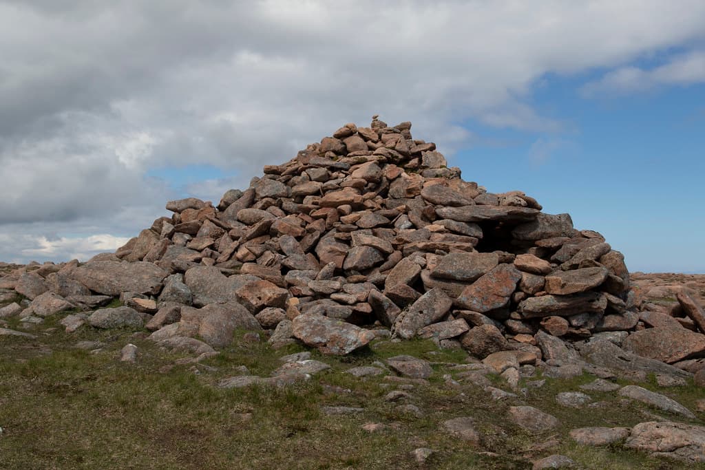
What the Neolithic builders placed here, perhaps five or six thousand years ago, is a heel-shaped chambered cairn — a tomb type found only in Shetland. It stands roughly 3.5 metres high, its concave facade facing outward, a passage leading to a rectangular burial chamber within. The form is distinctive: wider at the back, narrowing toward the entrance, shaped in plan like the heel of a shoe. This is not a casual deposit of stones. It is architecture, deliberately constructed at a location that required extraordinary effort to reach.
The cairn may be the highest chambered cairn in all of Scotland. From its position, nearly the whole of Shetland is visible — south toward Sumburgh and Fair Isle, across Yell Sound, and in every other direction, open ocean. The builders chose to house their dead at the one point in the archipelago where earth reaches closest to sky. That decision, made in the Neolithic period, still resonates. Local farmers reportedly left coins and other offerings in the cairn well into the twentieth century, a folk practice that ceased only when the Sullom Voe oil terminal construction in the 1970s brought traffic and disruption to this remote corner of Shetland.
Context and lineage
Sometime between roughly 4000 and 2500 BC, a Neolithic community in Shetland undertook to build a communal burial monument at the summit of the highest hill in the archipelago. The effort would have been considerable. Every stone had to be carried or sourced from the immediate summit area. The heel-shaped design — a form developed only in Shetland — required skilled construction: a concave facade, a passage aligned through the body of the cairn, a rectangular chamber within. The structure rose to approximately 3.5 metres, substantial enough to be visible from considerable distances below.
Why here, at 450 metres, exposed to every wind and weather the North Atlantic could deliver? The cairn's position is exceptional. Most Neolithic chambered cairns in Britain occupy prominent locations — hilltops, ridgelines, coastal headlands — but very few sit on the absolute summit of the highest point in a region. The builders were not choosing convenience or shelter. They were choosing maximum elevation, maximum exposure, maximum visibility. The dead would look out over the entire world the living inhabited.
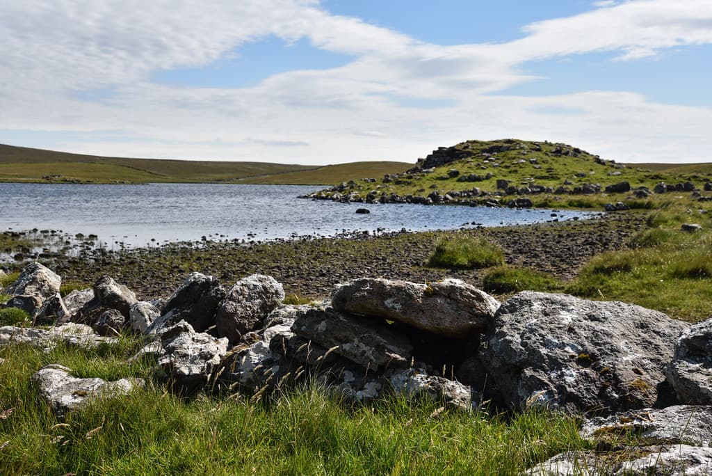
The heel-shaped cairn type is unique to Shetland. Approximately thirty examples are known across the islands, and they represent a distinctive regional development within the broader tradition of Neolithic chambered tomb building in Britain and Ireland. The Ronas Hill example is among the most dramatically sited of all. It forms part of a wider prehistoric landscape on the summit plateau — a second cairn 60 metres to the southwest and a platform 60 metres to the northwest suggest the hilltop was used for purposes beyond a single burial.
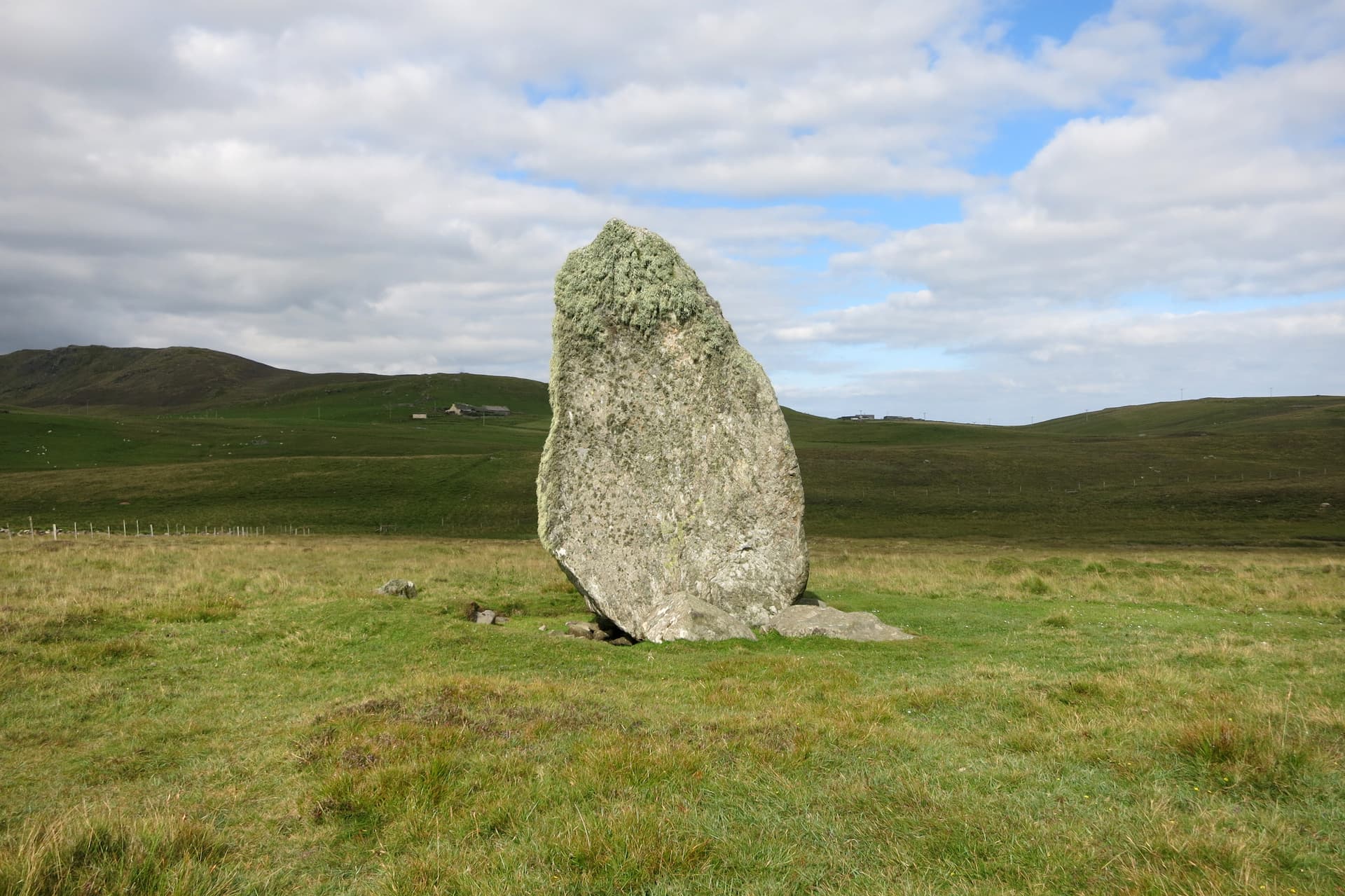
Shetland's giant legends later wrapped the hill in story. The giant of Ronas Hill, according to tradition, engaged in combat with the giant of Papa Stour. During their battle, a stone was hurled that fell short and became the Standing Stone of Busta, a 20-tonne granite monolith near Busta Voe, some 15 kilometres to the south. An alternative version places the throw in the opposite direction. These Norse-era legends, while not connected to the cairn's original builders, demonstrate the hill's enduring presence in Shetland's imaginative landscape.
The Ronas Hill Chambered Cairn belongs to the heel-shaped cairn tradition, a funerary architectural form unique to the Shetland Islands. Approximately thirty heel-shaped cairns have been identified in Shetland, including the well-preserved Mangaster example roughly 8 kilometres to the south in Northmavine. These cairns share a distinctive plan — wider at the back, narrowing toward the entrance, with a concave facade — that distinguishes them from the chambered cairns of Orkney (stalled cairns, Maeshowe-type) and the passage graves of mainland Scotland and Ireland. The heel-shaped form appears to be a regional adaptation of the broader Neolithic tradition of building monumental communal tombs. The tradition connects, at its widest extent, to the culture of megalithic tomb building that spread across Atlantic Europe during the fourth and third millennia BC, from Iberia to Scandinavia. In Shetland, nearby Neolithic sites include the felsite quarries at North Roe (approximately 5-8 kilometres northeast), where distinctive Shetland knives were manufactured, indicating a community with specialized craft skills and likely trade connections.
A.S. Henshall
RCAHMS (Royal Commission on the Ancient and Historical Monuments of Scotland)
Dr Aaron Watson
Why this place is sacred
Thinness at Ronas Hill operates through extremity. This is not a gentle, enclosed space. It is the most exposed, most elevated, most remote point in Shetland, and the Neolithic community that built here understood that exposure as significance.
Consider what the summit demands. There is no path. The approach crosses stony tundra where Arctic-alpine plants grow at the southernmost edge of their range — Mountain Azalea, Alpine Lady's Mantle, species that belong to Scandinavia and Iceland, not to Britain. The ground itself announces that you have crossed into a different ecological zone. At 450 metres, in a subarctic maritime climate, the summit exists in near-permanent wind. Mist arrives without warning and can reduce visibility to a few metres. Dr Aaron Watson, an archaeologist who has written about visiting the cairn, described the experience of the structure materialising from fog — a sudden encounter with ancient stone in a landscape where all other reference points had vanished.
The cairn's function deepens its liminality. This was a house of the dead. The rectangular chamber within held human remains, deposited over extended periods, the bones of multiple individuals accumulating across generations. The dead were placed at the highest accessible point in the archipelago — above the living, above the settlements, above the fields and the sea. Whatever cosmology drove that choice, it positioned the ancestors at a boundary. Below them, the world of the living. Above them, only sky.
The folk tradition of offerings compounds the thinness. Farmers in the area reported that the cairn contained coins, some described as very old, and other items left as sacrifices. This practice continued into living memory, ceasing only in the mid-1970s. The implication is striking: for millennia, across the transitions from Neolithic to Bronze Age to Iron Age to Norse to modern Shetlandic culture, people continued to recognise something at this summit that warranted acknowledgment. The specific beliefs changed; the impulse to leave something at this place between earth and sky persisted.
The panoramic visibility contributes its own quality. On clear days, the view encompasses nearly every island in Shetland, Fair Isle to the south, and the open waters of both the North Sea and the Atlantic Ocean. You see the entire world of the people who built the cairn. You see, too, how small that world was against the surrounding ocean, and how deliberate the choice to place the dead at its apex.
The cairn was built as a communal burial monument — a chambered tomb for the deposition of human remains and grave goods over an extended period. The heel-shaped form, with its concave facade and formal entrance passage, suggests the structure was also designed for ritual gatherings at its entrance. Placing the tomb at the summit of the highest hill in the archipelago indicates the builders assigned profound cosmological or spiritual significance to this location.
The cairn's upper structure shows evidence of substantial rebuilding — stones above the entry passage lack the lichen found on lower courses, suggesting later modification. Whether this represents Neolithic maintenance, Bronze Age reuse, or later-period alteration remains uncertain. The folk tradition of leaving offerings demonstrates that the site retained ritual significance long after its original funerary function ceased. RCAHMS documented the cairn in 1946 (with a visit recorded as early as 1931). A.S. Henshall studied the monument in 1963 as part of her analysis of chambered cairns. The cairn was first scheduled as a protected monument in 1955. Today, a modern shelter cairn with a trig pillar and visitor book sits nearby on the summit, and the site is visited primarily by hillwalkers and those with archaeological interest.
Traditions and practice
The cairn's primary function was funerary — the deposition of human remains and grave goods in the rectangular chamber over extended periods. The heel-shaped form, with its concave facade creating a shallow forecourt before the entrance, may have been designed for ritual gatherings. Those who came to deposit the dead or to honour ancestors would have approached through the facade area, entered the passage, and placed remains within the chamber. The architecture choreographed this approach: the concave facade draws the eye inward toward the entrance, the passage narrows and darkens, the chamber opens as a discrete interior space within the body of the cairn. In later centuries, a folk tradition of leaving offerings persisted — farmers from the surrounding area deposited coins, some reportedly very old, and other items within the cairn as sacrifices. This practice continued into the mid-1970s, ending when increased foot traffic from the Sullom Voe oil terminal construction disrupted the site's isolation.
The cairn is visited primarily by hillwalkers, archaeologists, and those drawn to Shetland's prehistoric heritage. A visitor book in a metal box within the nearby shelter cairn records the passage of those who reach the summit. No organized spiritual or ceremonial practices currently take place at the site.
Begin at the radio station on Collafirth Hill and walk north toward the summit. There is no path, and that matters. The absence of a trail means you must choose your own line across the tundra, reading the ground as you go. Let the walk itself be the preparation. Two miles across this terrain takes time. Use that time.
As you climb, attend to the ground underfoot. The vegetation changes with altitude — notice when the grasses thin and the Arctic-alpine species appear. Mountain Azalea grows in low, dense mats, flowering pink in June and July. Alpine Lady's Mantle clings to sheltered spots between stones. You are walking through an ecological boundary, a place where Britain gives way to the Arctic.
When the cairn comes into view, stop for a moment before approaching further. Take in its shape against the skyline. Note how the heel-shaped form is visible even from a distance, how the concave facade creates a shadow that distinguishes entrance from body. This was architecture designed to be seen and to be approached.
Circle the cairn before looking at the entrance. Observe its construction — the careful placement of stones, the way the structure widens toward the back. Notice the lichen patterns on the lower stones and their absence on the upper courses, evidence that the upper structure was rebuilt at some point after the original construction. Stand at the back of the cairn and look outward. What the dead within saw, in whatever sense seeing applies, was this: the whole of Shetland.
Return to the entrance and regard the passage. You should not enter — the cairn is a scheduled monument — but you can observe the passage's alignment and the darkness within. Consider that human remains were carried up this same hill and placed inside this chamber. The physical effort required to bring the dead to this summit was itself a ritual act.
Look for the second, smaller cairn approximately 60 metres to the southwest. A platform of uncertain purpose lies about 60 metres to the northwest. These three features together suggest the summit was used as a complex ritual landscape, not simply a single tomb.
Finally, stand still at the summit. If the day is clear, turn slowly through the full panorama. Sumburgh Head to the south. Yell Sound to the east. The open Atlantic to the north. Every direction ends in ocean. You are standing at the highest point of an archipelago in the North Atlantic, beside a structure placed here five or six thousand years ago by people who understood this position as worthy of their dead. Let the wind and the distance do what they will.
If the day is not clear — if mist wraps the summit — the experience shifts but does not diminish. The cairn in fog is perhaps even more affecting. You stand in a small clearing of visibility, the landscape erased, the ancient structure your only companion. The boundary between seen and unseen becomes literal.
Neolithic Funerary Tradition
HistoricalThe heel-shaped chambered cairn was built as a communal burial monument during the Neolithic period, approximately 4000-2500 BC. Heel-shaped cairns are found only in the Shetland Islands, representing a unique regional expression of Neolithic funerary architecture. The Ronas Hill example is among the most dramatically positioned, occupying the summit of the highest point in the archipelago.
The deposition of human remains and grave goods in the rectangular chamber over extended periods. The concave facade and formal entrance passage suggest choreographed ritual approaches. Excavation of comparable heel-shaped cairns elsewhere in Shetland indicates use for multiple interments across generations.
Folk Offering Tradition
HistoricalLocal farmers reported that the cairn contained a variety of sacrificial items — coins, some described as very old, and other objects — until the construction of Sullom Voe oil terminal in the mid-1970s disrupted the area's remoteness. This folk practice suggests the site retained ritual significance across millennia, well beyond its Neolithic origins.
The leaving of coins and other items within the cairn chamber as offerings or sacrifices. The practice appears to have been maintained by local Shetlanders over an unknown but potentially very long period, ending when increased foot traffic disrupted the site's isolation.
Norse Cultural Heritage
HistoricalRonas Hill's name derives from Old Norse, reflecting Shetland's Norse settlement period (c. 800-1469 AD). The hill features in a cycle of giant legends that explain landscape features through supernatural narratives — a tradition common across Norse cultural areas.
Oral storytelling connecting Ronas Hill to the wider legendary landscape. The combat between the giants of Ronas Hill and Papa Stour, and the creation of the Standing Stone of Busta through a thrown stone, represent a Norse-Shetlandic tradition of mythologizing the landscape.
Experience and perspectives
The experience begins at the radio station on Collafirth Hill, 233 metres above sea level. You park here, at the end of a tarmac service road, and step off the edge of maintained ground. There is no waymark, no signpost, no path. The summit of Ronas Hill is roughly two miles to the north-northwest, and the route to it crosses open, stony tundra.
The ground immediately feels different underfoot. Loose stones, thin peaty soil, and low-growing plants form a landscape that owes more to Svalbard than to Scotland. Mountain Azalea grows here in dense mats close to the ground — a plant of the Arctic, found this far south only because of the altitude and exposure. The walking is rough but not steep; the elevation gain is approximately 220 metres over the two-mile distance. What makes the approach demanding is the terrain itself — uneven, boggy in places, with no clear line to follow. Navigation requires a map, compass, or GPS, particularly if visibility deteriorates.
As you climb, the world simplifies. The settlements of Northmavine recede. The sounds of human activity fade. The wind, which is nearly constant at this latitude and altitude, becomes the primary companion. On clear days, the views expand progressively — Yell Sound to the east, Ronas Voe below to the southwest, and increasingly the open Atlantic to the north and west. On days of low cloud, the experience inverts: the world contracts to a few metres of stone and moss, and the walk becomes a negotiation with uncertainty.
The cairn announces itself from perhaps a hundred metres away on clear days. It rises roughly 3.5 metres above the summit plateau — a substantial structure, unmistakably artificial, its heel-shaped form and concave facade readable even from a distance. The entrance passage faces outward, and the rectangular chamber lies within. A second, smaller cairn sits approximately 60 metres to the southwest. A platform of uncertain purpose lies about 60 metres to the northwest. These three features together suggest coordinated use of the summit area.
Standing beside the cairn, you are at 450 metres — the highest point in Shetland. On clear days, nearly the entire archipelago spreads below. Sumburgh Head to the far south. The islands of Yell and Unst to the northeast. Fair Isle, halfway to Orkney, may be visible on exceptional days. The North Sea stretches east, the Atlantic west and north. The scale of ocean to land becomes visceral.
The modern shelter cairn with its trig pillar and visitor book sits a few metres away, a modest counterpart to its Neolithic neighbour. Some visitors sign the book. The juxtaposition — a metal box with a notebook beside a 5,000-year-old burial chamber — captures something about the continuity of human presence at this summit.
In mist, the experience is fundamentally altered. The cairn emerges from fog as a sudden, close presence. The panorama disappears. You stand in a small circle of visibility, surrounded by cloud, beside a structure built when the world was understood in terms now lost. The disorientation of mist at the summit can be genuinely unsettling, and archaeologist Aaron Watson has described this atmospheric encounter as particularly evocative — the tomb appearing and disappearing in the shifting visibility.
Ronas Hill is in the Northmavine peninsula, the northernmost part of Mainland Shetland. The chambered cairn sits on the summit at 450 metres. The approach is from the south, starting at the radio station on Collafirth Hill (233 metres). The cairn's entrance passage faces the viewer on approach. The second cairn is 60 metres to the southwest. The platform is 60 metres to the northwest. The modern trig pillar and shelter cairn are immediately adjacent.
The Ronas Hill Chambered Cairn is understood primarily through archaeological survey and comparative analysis with other Shetland cairns. No formal excavation has been carried out, and much about the site remains inferred rather than proven.
Archaeologists classify the cairn as a heel-shaped chambered cairn of the Neolithic period, approximately 4000-2500 BC. A.S. Henshall studied the monument in 1963 as part of her comprehensive work on Scotland's chambered cairns, placing it within the typology of heel-shaped cairns unique to Shetland. The Royal Commission on the Ancient and Historical Monuments of Scotland documented the site in 1946, with a visit recorded as early as 1931. The scheduled monument statement emphasizes the cairn's exceptional position on the summit of Shetland's highest hill, noting that this is highly unusual for Neolithic chambered cairns, which generally occupy prominent but not necessarily supreme positions. Evidence of substantial rebuilding of the upper structure — indicated by the absence of lichen on stones above the entry passage — suggests the monument was maintained or modified over an extended period. The cairn sits within a broader summit landscape including a second cairn and a platform, indicating coordinated use of the hilltop. Scholars have noted that the cairn was likely used for multiple interments over an extended period, consistent with the communal burial practices evidenced at excavated heel-shaped cairns elsewhere in Shetland. The relationship between heel-shaped cairns and other Neolithic monumental traditions in northern Scotland — particularly the stalled and Maeshowe-type cairns of Orkney — has been studied in academic literature, with the heel-shaped form interpreted as a distinctively Shetlandic adaptation.
Shetland's oral tradition connects Ronas Hill to a cycle of giant legends. The giant who dwelt on the hill fought the giant of Papa Stour, and during their combat a stone was hurled that fell short and became the Standing Stone of Busta, a 20-tonne granite monolith near Busta Voe. An alternative version reverses the direction of the throw. These legends, likely of Norse origin, reflect a wider northern European tradition of explaining landscape features through the actions of supernatural beings. The name Ronas Hill itself derives from Old Norse — probably from 'ron' meaning stony ground or scree — reflecting the Norse cultural layer that overlaid the much older Neolithic landscape. The folk practice of leaving coins and other sacrificial items in the cairn, attested by local farmers into the 1970s, represents a tradition of uncertain age and origin that may connect Norse-era or earlier beliefs about the dead and about hilltop sites to modern folk practice.
The cairn's extreme summit location has attracted interpretation as a deliberately chosen threshold between earthly and celestial realms. The positioning of the dead at the highest accessible point in the archipelago may reflect cosmological beliefs about the proximity of hilltops to the spirit world, or a desire to place ancestors as guardians overlooking the entire living landscape. Some visitors perceive the summit as a place of heightened awareness or spiritual sensitivity, attributing this to the combination of altitude, exposure, antiquity, and the effort required to reach it. No specific astronomical alignments have been documented for the cairn, though the panoramic horizon would lend itself to observation of solar and stellar phenomena.
The cairn has never been formally excavated, so its contents, construction sequence, and full burial record remain unknown. The exact dating within the broad 4000-2500 BC range has not been refined through radiocarbon analysis. The nature and age of the offering items reported by farmers — coins described as very old, along with other unspecified objects — were never formally catalogued, and their disappearance in the 1970s represents a loss of evidence for folk continuity at the site. The purpose of the substantial rebuilding of the upper structure is unclear: was it Neolithic maintenance, Bronze Age or Iron Age reuse, or later modification? The relationship between the main cairn, the smaller cairn to the southwest, and the platform to the northwest has not been systematically investigated. Perhaps most fundamentally, the question of why Neolithic builders chose this extreme summit when most contemporary cairns occupied less demanding prominent positions has no definitive answer.
Visit planning
Brae, approximately 20km south, offers the nearest range of accommodation including a hotel and self-catering options. North Roe has limited B&B accommodation. Lerwick, 55km south, provides the full range of hotels, B&Bs, and self-catering. Given the early start advisable for the walk, accommodation in Brae or North Roe minimizes travel time.
Respect the scheduled monument and the fragile Arctic-alpine ecology. Do not enter the cairn, leave objects, or disturb stonework. Leave no trace.
Proper hill-walking attire is essential, not optional. The summit is at 450 metres in a subarctic maritime climate where conditions can deteriorate rapidly. Waterproof jacket and trousers, warm layers, sturdy walking boots, hat, and gloves should be carried even in summer. Wind chill at the summit can be severe. In winter, full winter hill-walking equipment including extra layers, survival bag, torch, and additional food and water are necessary.
Photography is freely permitted. The cairn, the panoramic views, the Arctic-alpine vegetation, and the atmospheric conditions all merit documentation. No restrictions apply to non-commercial photography. The light at this latitude — particularly the low-angle illumination of early morning, late evening, and the midsummer simmer dim — can be extraordinary.
While there was a historical folk tradition of leaving coins and other items in the cairn, modern visitors should not leave any objects at the site. Placing items within or on the cairn could constitute unauthorized alteration of a scheduled monument. The site should be left exactly as found. The most appropriate offering is attentive presence.
As a Scheduled Monument, it is illegal to damage, destroy, or alter the monument or carry out any works without consent. Do not enter the passage or chamber. Do not climb on the cairn. Do not remove any stones or materials. No camping or fires on or near the monument. The SAC designation means visitors should minimize ecological impact — stay on stony ground where possible, do not pick plants, and carry all waste out. Dogs should be kept under close control.
Plan your visit
Address
Shetland ZE2 9RX, UK
Hours, fees, and access can change — verify on the official source before you travel. Practical details last checked Jun 2026.
Nearby sacred places
Sacred places within a half-day’s reach. Pilgrims often visit them together: walk one, stay for the other.

References
Sources consulted when researching this page. Independent verification by readers is welcome.
- 01Site in Focus - Ronas Hill Chambered Cairn — Archaeology Shetlandhigh-reliability
- 02Ronas Hill, chambered cairn (Scheduled Monument SM2043) — Historic Environment Scotlandhigh-reliability
- 03Ronas Hill, chambered cairn, Shetland North, Shetland Islands — Ancient Monuments UKhigh-reliability
- 04Ronas Hill - Canmore Record — Historic Environment Scotland / Canmorehigh-reliability
- 05Shetland: In the mist on Ronas Hill — Dr Aaron Watsonhigh-reliability
- 06Ronas Hill - North Roe Special Area of Conservation — JNCC (Joint Nature Conservation Committee)high-reliability
- 07Ronas Hill - North Roe & Tingon, Ramsar Information Sheet — Ramsar Sites Information Servicehigh-reliability
- 08The so-called heel-shaped cairns of Shetland, with remarks on the chambered tombs of Orkney and Shetland — Proceedings of the Society of Antiquaries of Scotlandhigh-reliability
- 09In Depth - The Mysteries of Northmavine — Archaeology Shetlandhigh-reliability
- 10Ronas Hill - Wikipedia — Wikipedia contributors
Key questions
What pilgrims usually ask
- Why is Ronas Hill Chambered Cairn considered sacred?
- Visit the Neolithic chambered cairn on Ronas Hill, Shetland's highest summit at 450m. A 5,000-year-old heel-shaped tomb with panoramic views across the archipel
- What should I wear at Ronas Hill Chambered Cairn?
- Proper hill-walking attire is essential, not optional. The summit is at 450 metres in a subarctic maritime climate where conditions can deteriorate rapidly. Waterproof jacket and trousers, warm layers, sturdy walking boots, hat, and gloves should be carried even in summer. Wind chill at the summit can be severe. In winter, full winter hill-walking equipment including extra layers, survival bag, torch, and additional food and water are necessary.
- Can I take photos at Ronas Hill Chambered Cairn?
- Photography is freely permitted. The cairn, the panoramic views, the Arctic-alpine vegetation, and the atmospheric conditions all merit documentation. No restrictions apply to non-commercial photography. The light at this latitude — particularly the low-angle illumination of early morning, late evening, and the midsummer simmer dim — can be extraordinary.
- How long should I spend at Ronas Hill Chambered Cairn?
- 4-5 hours allowing time at the summit to explore the cairn, observe the landscape, and sit with the experience
- What offerings are appropriate at Ronas Hill Chambered Cairn?
- While there was a historical folk tradition of leaving coins and other items in the cairn, modern visitors should not leave any objects at the site. Placing items within or on the cairn could constitute unauthorized alteration of a scheduled monument. The site should be left exactly as found. The most appropriate offering is attentive presence.
- What etiquette should visitors follow at Ronas Hill Chambered Cairn?
- Respect the scheduled monument and the fragile Arctic-alpine ecology. Do not enter the cairn, leave objects, or disturb stonework. Leave no trace.
- What is the history of Ronas Hill Chambered Cairn?
- Sometime between roughly 4000 and 2500 BC, a Neolithic community in Shetland undertook to build a communal burial monument at the summit of the highest hill in the archipelago. The effort would have been considerable. Every stone had to be carried or sourced from the immediate summit area. The heel-shaped design — a form developed only in Shetland — required skilled construction: a concave facade, a passage aligned through the body of the cairn, a rectangular chamber within. The structure rose to approximately 3.5 metres, substantial enough to be visible from considerable distances below. Why here, at 450 metres, exposed to every wind and weather the North Atlantic could deliver? The cairn's position is exceptional. Most Neolithic chambered cairns in Britain occupy prominent locations — hilltops, ridgelines, coastal headlands — but very few sit on the absolute summit of the highest point in a region. The builders were not choosing convenience or shelter. They were choosing maximum elevation, maximum exposure, maximum visibility. The dead would look out over the entire world the living inhabited. The heel-shaped cairn type is unique to Shetland. Approximately thirty examples are known across the islands, and they represent a distinctive regional development within the broader tradition of Neolithic chambered tomb building in Britain and Ireland. The Ronas Hill example is among the most dramatically sited of all. It forms part of a wider prehistoric landscape on the summit plateau — a second cairn 60 metres to the southwest and a platform 60 metres to the northwest suggest the hilltop was used for purposes beyond a single burial. Shetland's giant legends later wrapped the hill in story. The giant of Ronas Hill, according to tradition, engaged in combat with the giant of Papa Stour. During their battle, a stone was hurled that fell short and became the Standing Stone of Busta, a 20-tonne granite monolith near Busta Voe, some 15 kilometres to the south. An alternative version places the throw in the opposite direction. These Norse-era legends, while not connected to the cairn's original builders, demonstrate the hill's enduring presence in Shetland's imaginative landscape.
- Who is associated with Ronas Hill Chambered Cairn?
- A.S. Henshall, RCAHMS (Royal Commission on the Ancient and Historical Monuments of Scotland), Dr Aaron Watson