Syrjäsalmi Rock Painting
Ochre marks on gneiss nearly two billion years older than the paint itself
Puumala, Puumala / Saimaa area – South Savo, Finland
Plan this visit
Practical context before you go
20–30 minutes for the walk in from the road and time spent at the viewing point.
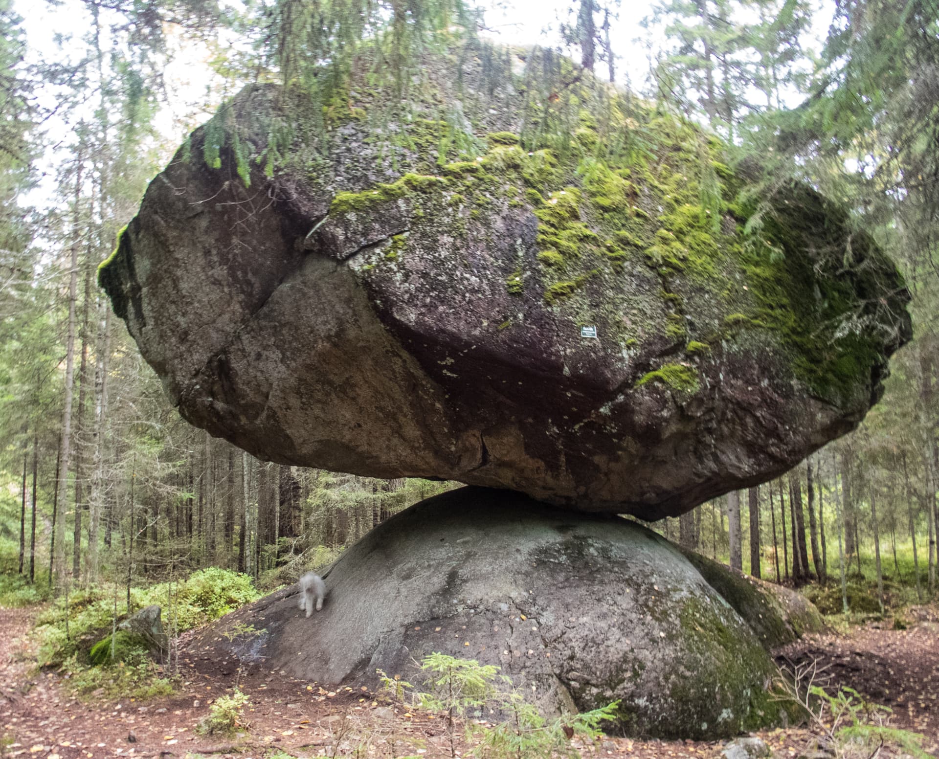
Located in Puumala, South Savo, on the shore of Ummistonvesi at the edge of Lake Saimaa, in a bay called Syrjälahti behind Syrjäsaari island. A marked trail of approximately 200 meters leads from road 15169 to the site, passing between two large erratic boulders at the trailhead, with a Saimaa Geopark information sign posted at the location. No mobile phone signal information was available at time of writing; for current access guidance, contact Visit Puumala at visit@puumala.fi or +358 44 902 3455, weekdays 9:00–16:00. No specific seasonal closure was found in research; the trail is designed for general foot access, though winter snow and ice will affect conditions.
A formally developed geopark site with marked trail and signage; etiquette centers on staying on-trail and leaving the ancient surface untouched.
At a glance
- Coordinates
- 61.5321, 28.3138
- Type
- Rock Art Site
- Suggested duration
- 20–30 minutes for the walk in from the road and time spent at the viewing point.
- Access
- Located in Puumala, South Savo, on the shore of Ummistonvesi at the edge of Lake Saimaa, in a bay called Syrjälahti behind Syrjäsaari island. A marked trail of approximately 200 meters leads from road 15169 to the site, passing between two large erratic boulders at the trailhead, with a Saimaa Geopark information sign posted at the location. No mobile phone signal information was available at time of writing; for current access guidance, contact Visit Puumala at visit@puumala.fi or +358 44 902 3455, weekdays 9:00–16:00. No specific seasonal closure was found in research; the trail is designed for general foot access, though winter snow and ice will affect conditions.
Pilgrim tips
- Sturdy walking shoes are recommended for the boulder-strewn, needle-lined approach path.
- Photography is permitted and actively encouraged as part of the geopark's interpretive mission.
- Do not touch or attempt to enhance the pigment. Stay on the marked trail to avoid damaging surrounding terrain and vegetation.
Overview
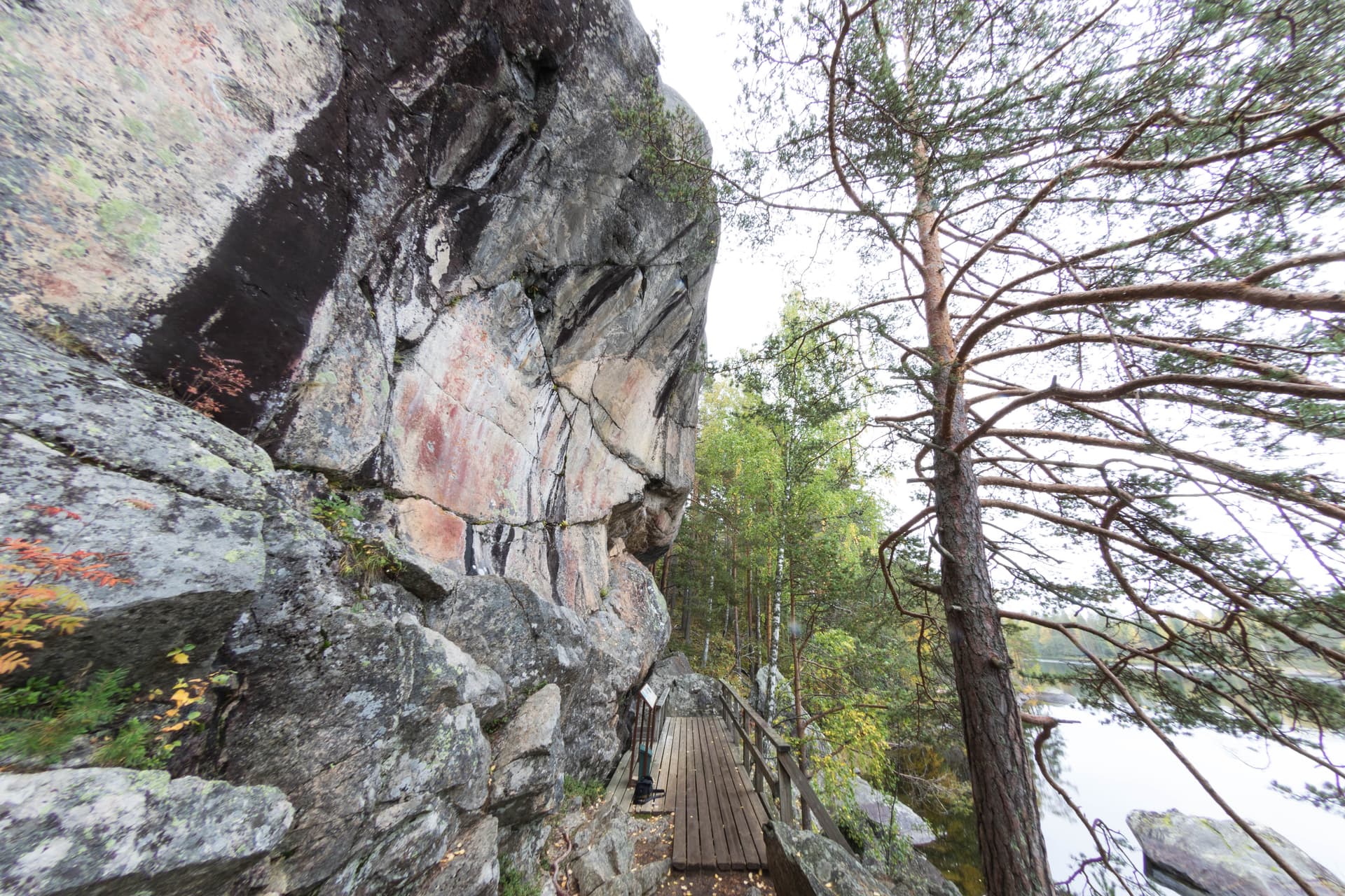
At a narrow bay of Lake Saimaa in Puumala, red ochre figures — stick people, a worn moose, a round-headed human form — span three height levels on a rock face of 1.9-billion-year-old gneiss. A marked geopark trail, flanked by two erratic boulders, now leads walkers to a painting between 3,500 and 6,000 years old.
Syrjäsalmi asks its visitors to hold two timescales at once. The rock itself — veined gneiss, streaked with lighter granite intrusions — formed 1.9 billion years ago, a span of time that makes the site's Stone Age paintings, at most six thousand years old, look almost recent by comparison. The paintings were identified on a bay of Ummistonvesi called Syrjälahti, tucked behind Syrjäsaari island. Today the Saimaa UNESCO Global Geopark maintains the site as one of its official geosites, with a marked 200-meter trail leading in from road 15169, passing between two large erratic boulders that stand at the trailhead like informal gateposts. Two groups of figures occupy the rock face across three distinct height levels: on the left, simple stick figures roughly 5.5 meters above today's water; on the right, a more extensive composition spanning all three levels — a worn moose, a round-headed human figure, and a scatter of less legible marks, with the lowest level dominated by a broad patch of red pigment whose original form has been lost to weathering.
Context and lineage
The paintings at Syrjäsalmi were made by Stone Age hunter-fisher-gatherer communities living around what is now Ummistonvesi bay, at a time when Lake Saimaa's water level stood measurably higher than today. The three height levels on the right-hand group of figures directly reflect that retreating shoreline, allowing archaeologists to sequence the images chronologically using the same shore-displacement method applied across the wider Saimaa rock-art corpus.
Stone Age hunter-fisher-gatherer culture of the Saimaa/Ummistonvesi basin → later identification and documentation → national ancient monument protection → formal incorporation into the Saimaa UNESCO Global Geopark's geosite network
Why this place is sacred
Puumala's tourism office describes the municipality, with some justification, as being 'at the forefront of rock painting discoveries in Finland' — nine separate sites are documented within its borders, of which Syrjäsalmi is among the most accessible and best interpreted. What sets it apart from a purely archaeological curiosity is the explicit geological framing the Saimaa Geopark brings to the site: the gneiss the figures are painted on predates the paintings by roughly 1.9 billion years, a number so large it resists intuitive comprehension, set beside a human mark that is, by any other measure, extremely old in its own right. The pigment itself is thought to have been mixed with a binder — blood, fat, or egg yolk — a detail that ties the abstract red patches and stick figures back to bodily and animal substance, however faded the visible trace has become. The three-level composition on the right side of the panel, its highest figures dating older than the lowest by virtue of the lake's slow retreat, gives the site an unusual legibility: you can, in effect, read the water's own history in how high or low a given figure sits.
Likely tied to travel, hunting, or invocatory ritual associated with the lake, consistent with the pigment's probable organic binder and the site's direct relationship to the historical shoreline.
Painted in the Stone Age, between roughly 4000 and 1500 BCE, based on shore-displacement dating of the three height levels; subsequently documented by the Finnish Rock Art Association and Ismo Luukkonen; formally developed as a marked, signed geosite of the Saimaa UNESCO Global Geopark.
Traditions and practice
The surviving evidence is entirely visual: red ochre pigment, likely mixed with a binder such as blood, fat, or egg yolk, applied to a face of veined gneiss across two groups and three height levels — stick figures, a worn moose, a round-headed human figure, and a dominant red patch at the lowest, oldest-water level. No ceremonial or narrative record survives beyond the imagery and its geological context.
None; the site has no living ritual use, though it functions actively as a public geological and archaeological interpretive site within the Saimaa Geopark network.
Walk the trail slowly enough to notice the two erratic boulders at its start as a deliberate threshold, not merely a landmark. At the rock face, resist looking only for the most legible figure — the worn moose or the stick figures — and give the lowest, least legible red patch equal attention; its very illegibility is part of what six millennia of weather has done here. If your schedule allows, pair the visit with one of Puumala's other eight documented rock-painting sites, or with Astuvansalmi about an hour away, to sense the density of this rock-art landscape.
Stone Age Ummistonvesi Rock Painting Tradition
HistoricalOne of nine documented rock-painting sites in Puumala, with two groups of figures spanning three height levels dated between roughly 6,000 and 3,500 years old via shore-displacement chronology.
Red ochre pigment, likely mixed with an organic binder, applied to a face of 1.9-billion-year-old veined gneiss at Ummistonvesi bay.
Archaeological Heritage & Geopark Interpretation
ActiveFormally recognized as a geosite of the Saimaa UNESCO Global Geopark, with a marked trail, signage, and active geological and archaeological interpretation for the public.
Site inventory and photographic documentation; geopark signage and trail maintenance; ongoing regional rock-art scholarship.
Experience and perspectives
Turn off road 15169 onto the marked path, and the first thing you meet is not the painting but the two erratic boulders standing at the trailhead — glacial deposits that predate the site's human history by their own long measure, and a fitting overture to a place that keeps asking you to think in centuries and then, without warning, in billions of years. The 200-meter trail is needle-lined and easy underfoot in the warmer months. At the rock face, take the geopark's signage seriously rather than skipping to the painting itself: knowing that the gneiss beneath the ochre is 1.9 billion years old changes how the human marks read against it. Locate the left-hand group of stick figures first, roughly 5.5 meters above today's water — simple, upright forms with little ambiguity. Then move to the right-hand group, more extensive and harder to parse: a moose worn nearly to a suggestion of itself, a round-headed human figure, and, at the lowest level, a broad field of red pigment whose original shape has dissolved into a stain. Spend time with that lowest patch in particular — it is the least legible element and, in its illegibility, the most honest record of what six thousand years does to red ochre on open rock.
Read the geopark's geological signage before or alongside the archaeological detail; let the two timescales inform each other rather than treating the geology as background.
Syrjäsalmi is distinguished less by any single dramatic image than by the explicit, geopark-framed juxtaposition of a nearly two-billion-year-old rock face and a several-thousand-year-old human mark upon it.
Finnish rock-art specialists and the Saimaa UNESCO Global Geopark place Syrjäsalmi within the well-documented regional corpus of Saimaa Stone Age red ochre paintings, dated via shore-displacement chronology to roughly 4000–1500 BCE, and interpreted through the same subsistence- and travel-related ritual frameworks applied across the basin.
No living community traces direct descent from the site's creators; it is held as shared Finnish national prehistoric heritage and actively promoted as part of a UNESCO-affiliated geological and cultural heritage story.
Geopark and tourism material emphasizes the site's deep-time geological framing as a way of making the human history legible to visitors, a pedagogical device rather than an esoteric claim about the site's meaning.
The specific ceremonial context linking the two groups of figures across three height levels, and the original form of the large red patch at the lowest, most weathered level, remain unresolved.
Visit planning
Located in Puumala, South Savo, on the shore of Ummistonvesi at the edge of Lake Saimaa, in a bay called Syrjälahti behind Syrjäsaari island. A marked trail of approximately 200 meters leads from road 15169 to the site, passing between two large erratic boulders at the trailhead, with a Saimaa Geopark information sign posted at the location. No mobile phone signal information was available at time of writing; for current access guidance, contact Visit Puumala at visit@puumala.fi or +358 44 902 3455, weekdays 9:00–16:00. No specific seasonal closure was found in research; the trail is designed for general foot access, though winter snow and ice will affect conditions.
Puumala village offers the nearest lodging and services, with the municipal tourism office (Keskustie 14, 52200 Puumala) able to advise on visiting multiple rock-art sites in the area.
A formally developed geopark site with marked trail and signage; etiquette centers on staying on-trail and leaving the ancient surface untouched.
Sturdy walking shoes are recommended for the boulder-strewn, needle-lined approach path.
Photography is permitted and actively encouraged as part of the geopark's interpretive mission.
None are appropriate; leaving objects or markings at the site risks violating its protected status.
Touching or scraping the pigment is prohibited under the Finnish Antiquities Act; visitors should remain on the marked trail rather than venturing off-path toward the rock face.
Nearby sacred places
Sacred places within a half-day’s reach. Pilgrims often visit them together: walk one, stay for the other.
Kummakivi
Ruokolahti, Ruokolahti – South Karelia, Finland
7.5 km away

Sulkava Linnavuori
Sulkava, Sulkava – South Savo, Finland
24.6 km away

Kolmiköytisienvuori Rock Painting
Ruokolahti, Ruokolahti – South Karelia, Finland
33.5 km away
Astuvansalmi Rock Paintings
Mikkeli (Ristiina), Mikkeli / Ristiina – South Savo, Finland
42.5 km away
References
Sources consulted when researching this page. Independent verification by readers is welcome.
- 01Rock paintings – Visit Puumala — Visit Puumala (municipal tourism office)high-reliability
- 02Syrjäsalmen kalliomaalaus / Syrjäsalmi Rock Painting – Saimaa Geopark — Saimaa UNESCO Global Geoparkhigh-reliability
- 03Syrjäsalmen kalliomaalaus – Wikipedia — Wikipedia contributors
- 04Syrjäsalmi, Puumala – Suomen kalliotaideyhdistys — Suomen kalliotaideyhdistys (Finnish Rock Art Association)
- 05Syrjäsalmi – ismoluukkonen.net kalliotaide — Ismo Luukkonen
- 06Syrjäsalmi rock painting – Biotope and geotope, Outdooractive — Outdooractive
Key questions
What pilgrims usually ask
- Why is Syrjäsalmi Rock Painting considered sacred?
- Walk a marked trail to Stone Age ochre figures on 1.9-billion-year-old gneiss at Syrjäsalmi, Puumala's Saimaa Geopark site.
- What should I wear at Syrjäsalmi Rock Painting?
- Sturdy walking shoes are recommended for the boulder-strewn, needle-lined approach path.
- Can I take photos at Syrjäsalmi Rock Painting?
- Photography is permitted and actively encouraged as part of the geopark's interpretive mission.
- How long should I spend at Syrjäsalmi Rock Painting?
- 20–30 minutes for the walk in from the road and time spent at the viewing point.
- How do you visit Syrjäsalmi Rock Painting?
- Located in Puumala, South Savo, on the shore of Ummistonvesi at the edge of Lake Saimaa, in a bay called Syrjälahti behind Syrjäsaari island. A marked trail of approximately 200 meters leads from road 15169 to the site, passing between two large erratic boulders at the trailhead, with a Saimaa Geopark information sign posted at the location. No mobile phone signal information was available at time of writing; for current access guidance, contact Visit Puumala at visit@puumala.fi or +358 44 902 3455, weekdays 9:00–16:00. No specific seasonal closure was found in research; the trail is designed for general foot access, though winter snow and ice will affect conditions.
- What offerings are appropriate at Syrjäsalmi Rock Painting?
- None are appropriate; leaving objects or markings at the site risks violating its protected status.
- What etiquette should visitors follow at Syrjäsalmi Rock Painting?
- A formally developed geopark site with marked trail and signage; etiquette centers on staying on-trail and leaving the ancient surface untouched.
- What is the history of Syrjäsalmi Rock Painting?
- The paintings at Syrjäsalmi were made by Stone Age hunter-fisher-gatherer communities living around what is now Ummistonvesi bay, at a time when Lake Saimaa's water level stood measurably higher than today. The three height levels on the right-hand group of figures directly reflect that retreating shoreline, allowing archaeologists to sequence the images chronologically using the same shore-displacement method applied across the wider Saimaa rock-art corpus.