Kummakivi
A boulder the Ice Age left standing on almost nothing
Ruokolahti, Ruokolahti – South Karelia, Finland
Plan this visit
Practical context before you go
The boulder itself can be reached and viewed in roughly 30-45 minutes round trip from the parking area, covering about one kilometre of walking. Visitors who extend the route to include the Sammalsilta moss-bridge loop toward Pitkäjärvi lake should plan for closer to one to one and a half hours to cover the full 2.3-kilometre circuit.
Kummakivi sits off the road Kummakiventie in Ruokolahti municipality, South Karelia, near the boundary with Puumala (approximate address Kummakiventie 56-58, 56310 Ruokolahti). A parking area at the road's end is free and unrestricted, from which a signposted but sometimes informal forest path of around half a kilometre leads to the site; no entrance fee applies. Mobile phone signal reliability specifically at the boulder was not addressed in any source consulted; given the rural, forested setting away from town centers, visitors should not assume strong or continuous coverage and are advised to save offline maps or directions beforehand as a precaution — this is a general caution rather than a sourced fact about signal strength at this exact location. For current access conditions, keyholder information is not applicable, as the site is open and unstaffed; questions can be directed to VisitRuokolahti or the Saimaa Geopark visitor information channels.
Etiquette at Kummakivi is straightforward outdoor courtesy rather than devotional protocol: stay off the boulder, keep to the path, and leave the site as found.
At a glance
- Coordinates
- 61.4933, 28.4300
- Type
- Balancing Rock / Glacial Erratic
- Suggested duration
- The boulder itself can be reached and viewed in roughly 30-45 minutes round trip from the parking area, covering about one kilometre of walking. Visitors who extend the route to include the Sammalsilta moss-bridge loop toward Pitkäjärvi lake should plan for closer to one to one and a half hours to cover the full 2.3-kilometre circuit.
- Access
- Kummakivi sits off the road Kummakiventie in Ruokolahti municipality, South Karelia, near the boundary with Puumala (approximate address Kummakiventie 56-58, 56310 Ruokolahti). A parking area at the road's end is free and unrestricted, from which a signposted but sometimes informal forest path of around half a kilometre leads to the site; no entrance fee applies. Mobile phone signal reliability specifically at the boulder was not addressed in any source consulted; given the rural, forested setting away from town centers, visitors should not assume strong or continuous coverage and are advised to save offline maps or directions beforehand as a precaution — this is a general caution rather than a sourced fact about signal strength at this exact location. For current access conditions, keyholder information is not applicable, as the site is open and unstaffed; questions can be directed to VisitRuokolahti or the Saimaa Geopark visitor information channels.
Pilgrim tips
- Ordinary outdoor clothing is sufficient. Sturdy, weather-appropriate footwear is worth prioritizing, since multiple visitor accounts note the forest path can be muddy after rain and snow-covered in winter.
- Photography is unrestricted and is, in fact, the dominant form of visitor engagement with the site; no source consulted noted any prohibition or sensitivity around photographing the boulder.
- Do not attempt to climb or rock the boulder; this is prohibited to protect the formation, and the informal ladder-climbing recorded in the early twentieth century is no longer permitted under any circumstances. The forest path can be uneven and slippery after rain or in winter conditions, so footwear suited to a soft, sometimes muddy trail is advisable.
Overview
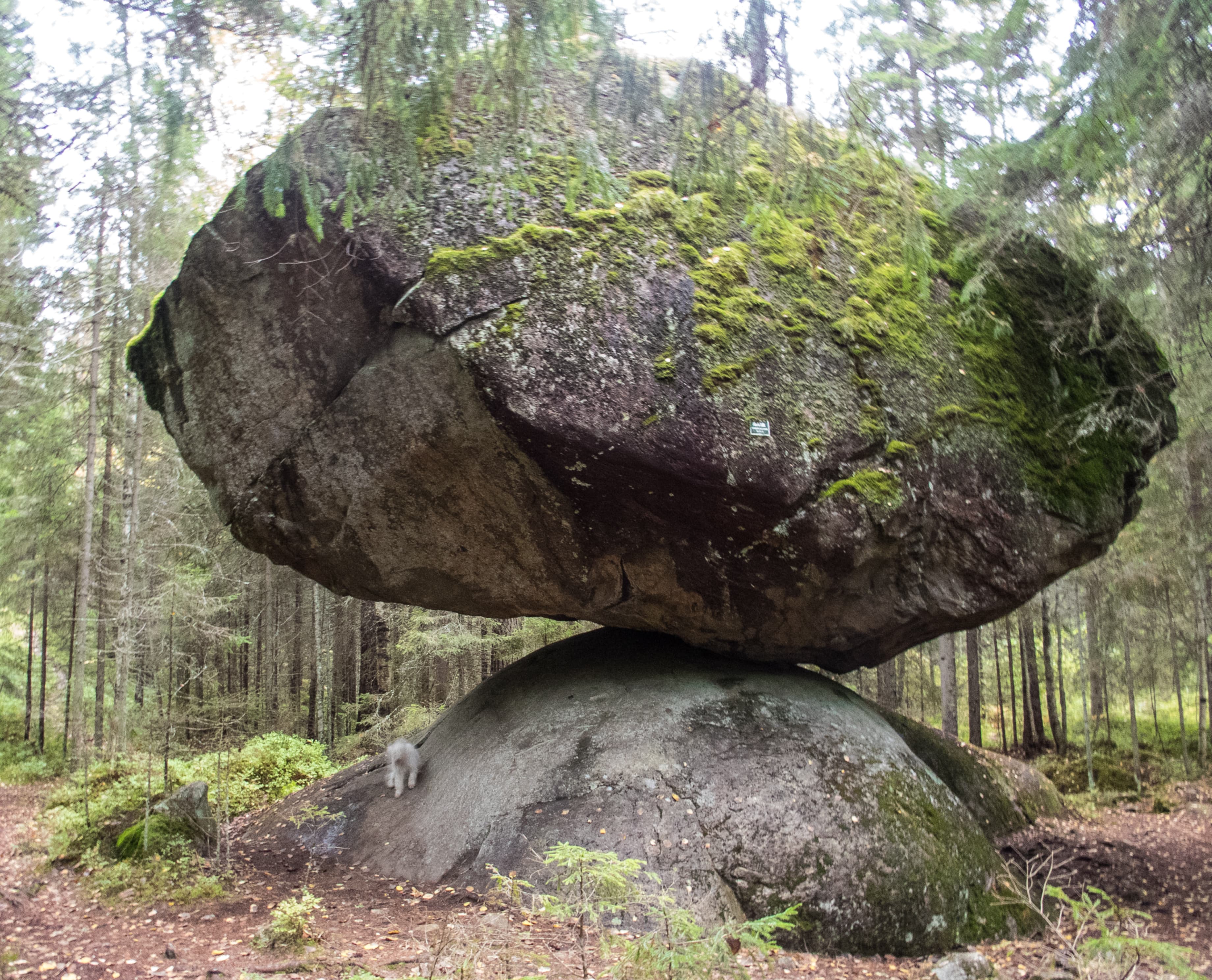
Kummakivi is a seven-metre glacial boulder in Ruokolahti, Finland, balanced on a smooth bedrock outcrop with barely half a square metre of contact. Local folklore explained the impossible-looking stance as the work of giants; geologists attribute it to a retreating ice sheet roughly 11,000 years ago.
In a quiet stretch of forest between Ruokolahti and Puumala, in Finland's South Karelia region, a boulder the size of a small house appears to hover on the edge of falling. Kummakivi — 'the strange stone' — rests on a rounded outcrop of ice-smoothed bedrock, touching it across less than a square metre. It has held that position since the last glacier retreated from this part of Fennoscandia, and it has resisted every recorded attempt to push, rock, or otherwise dislodge it by hand. For generations before anyone could explain the mechanics of glacial deposition, people who came upon the stone reached for the only explanation the landscape offered: that something larger than a person — a giant, a troll, a hiisi spirit said to inhabit rocky ground — must have set it there. That story persists in the telling even after the geology is understood, because seeing the stone does not fully dissolve the impression it makes. Kummakivi is protected today as a natural monument and anchors one of the geosites of the Saimaa UNESCO Global Geopark, visited less as a place of ritual than as a place where deep time and old stories sit visibly on top of one another.
Context and lineage
Geologically, Kummakivi is the product of the last deglaciation of Fennoscandia. As the continental ice sheet melted and retreated northward roughly 11,000 to 12,000 years ago, it carried this granite-cordierite-mica gneiss boulder and set it down on a roche moutonnée whose surface had been smoothed and rounded by the same ice movement. The near-match between the boulder's underside and the bedrock's curve, together with the stone's low centre of gravity, is what lets it rest stably on a contact area of only about half a square metre. Culturally, the stone's earliest documented human history is one of curiosity rather than reverence: Russian tourists are recorded visiting in the 1800s, and in the early twentieth century local youths placed ladders against the boulder to climb and gather on top of it, a practice long since ended by its protected status. Alongside that documented history ran an older, undated oral explanation — that a giant or troll had rolled, thrown, or carefully set the stone in place, sometimes framed as a wager between two such beings — consistent with a wider Finnish tradition of jättiläistarinat, giant-legends attached to unusual boulders across the country. It is not established when this legend was first written down or by whom; it survives as retold local tradition rather than as a text with a known author.
Kummakivi belongs to no institutional or devotional lineage; its continuity is that of a landscape feature repeatedly re-interpreted — first through Finnish folk explanations involving giants and hiisi spirits, later through nineteenth- and twentieth-century curiosity visits, and now through the scientific and conservation framework of the Saimaa UNESCO Global Geopark, established in 2021.
Why this place is sacred
What draws people to Kummakivi is not a doctrine or a devotional history but a specific, repeatable sensory experience: standing in front of a seven-metre stone that the eye insists cannot be stable, and discovering that it is. The boulder sits on a roche moutonnée — a bedrock knob smoothed and rounded by the passage of ice — whose curve happens to closely match the underside of the stone. That coincidence of shape allows a boulder with a low centre of gravity and a tiny footprint to remain immovable while looking like the opposite. The discomfort this produces in visitors is old. It shows up in the earliest recorded reactions to the stone — nineteenth-century travelers and, not long after, local youths who propped ladders against it to climb up and sit — and it shows up just as reliably today, in visitors who already know, before arriving, that the stone is glacially deposited and not floating on hidden supports. Knowing the explanation does not remove the visual tension; it just reframes it. The site's meaning has shifted over time, from a landscape animated by hiisi and giants blamed for scattering stones across the Finnish countryside, to one read through the vocabulary of geology and conservation — but the felt strangeness that gave the stone its name predates both explanations and outlasts either one.
Traditions and practice
No tradition of ritual or ceremonial practice at the boulder itself is documented in available sources. The historical human activity recorded here — nineteenth-century sightseeing visits and early-twentieth-century ladder-climbing by local youths — was informal and curiosity-driven rather than devotional, and ended once the site was formally protected in 1962.
Present-day engagement with the site is centered on geopark interpretation: reading the Saimaa Geopark's on-site signage, which explains the boulder's composition and glacial history, and walking the short trail network that connects it to the Sammalsilta moss bridge and Pitkäjärvi lake.
Walk fully around the boulder before forming an impression of it — the sense that it is precariously balanced is strongest from certain angles and noticeably weaker from others, and noticing that shift is closer to the point of visiting than any single photograph. Pause at the point of minimum contact between stone and bedrock, where the geopark signage marks the roughly half-square-metre touch point, before moving on to the moss bridge if extending the walk.
Finnish Folk Religion
ActiveKummakivi's improbable balance made it a natural focus within a broader Finnish folk cosmology in which rocky, forested landscapes were understood as inhabited by hiisi and other spirit-beings, and in which unusual boulders were routinely explained through the agency of giants or trolls rather than left as unexplained curiosities.
The tradition survives today as retold folklore rather than active ritual: tourism material and folklore-interest writing continue to recount the giant/troll origin story to visitors, keeping the narrative alive as color and context rather than as practiced belief.
Geological and Geopark Stewardship
ActiveAs a flagship geosite of the Saimaa UNESCO Global Geopark, Kummakivi is actively maintained as a site of ongoing geological interpretation, connecting the deep-time story of Fennoscandian deglaciation to present-day heritage tourism and conservation practice.
Interpretive signage, trail maintenance, and inclusion in the geopark's network of 65 geosites across nine municipalities constitute the site's living institutional tradition, alongside continued dating and research into the region's glacial history.
Experience and perspectives
The approach begins at a small parking area at the end of Kummakiventie, a paved road that climbs into forest away from the main routes through Ruokolahti. From there a short, mostly easy path — sometimes soft or muddy underfoot after rain — leads into pine and mixed forest for around half a kilometre before the trees open onto the outcrop. Saimaa Geopark signage at the site gives the geological account: the granite-cordierite-mica gneiss composition of both boulder and bedrock, the glacial transport that carried the stone here, the roughly 11,000 years since the ice retreated far enough for it to be set down. Visitors typically spend a few minutes circling the stone before the illusion of imbalance settles into something closer to appreciation — the same physical fact read as menace from one side and as elegant improbability from another. Climbing on the boulder is not permitted, a restriction most visitors observe without difficulty, since the appeal here has more to do with looking than touching. Many extend the visit along the connected Sammalsilta route, a roughly 2.3-kilometre loop crossing a log walkway — the 'moss bridge' — built in the 1930s by workers from the Kaukas logging company and still in use, now for hikers, on its way toward an island in Pitkäjärvi lake. The overall register of a visit is quiet rather than dramatic: a brief, physically undemanding walk that rewards attention more than exertion, in forest that changes sharply between summer's cover and winter's stripped stillness.
Kummakivi is read through at least three distinct lenses that rarely need to argue with one another: a geological account of how the stone came to rest as it did, a folk-narrative account of why people who lacked that science reached for giants and spirits to explain it, and a thinner, less corroborated layer of modern speculation about the site's possible pre-Christian ritual use.
Geologists explain Kummakivi as a glacial erratic transported and deposited during the retreat of the Fennoscandian ice sheet at the end of the last Ice Age, roughly 11,000 to 12,000 years ago according to dating work credited to geologist Aimo Kejonen. The boulder rests on a roche moutonnée, a bedrock surface rounded by the same ice movement, and the close match between the outcrop's curvature and the boulder's underside — combined with its low centre of gravity — accounts for its stability despite a contact area of only around half a square metre. A widely repeated claim that the boulder weighs approximately 500 tonnes could not be verified against a reliable source; a Snopes fact-check found the roughly 11,000-11,500-year age estimate essentially accurate while rating the weight figure unconfirmed.
Finnish folk tradition accounted for the stone's implausible stability through the agency of giants, trolls, or hiisi — nature spirits associated in Finnish belief with rocky and forested ground, said to be responsible for scattering boulders, piling cairns, and carving odd shapes into stone across the landscape. Local stories describe the giant or troll carrying, rolling, or throwing the stone into place, occasionally framed as a marker or the result of a wager between two such beings. This sits within a broader Finnish tradition of jättiläistarinat, giant-legends attached to unusual rock formations nationwide, and of tarinakivet, 'story-stones' whose physical oddity generates and sustains oral narrative.
A small number of lower-reliability travel-culture sources suggest Kummakivi may have served as a site of pre-Christian ritual or animistic practice, with some framing it as a place where shamans or mystics once communed with nature spirits. This framing is not corroborated by the Saimaa Geopark, the municipal tourism authority, or encyclopedia sources consulted for this profile, and should be treated as unverified popular speculation rather than documented history.
It is not established when the giant/troll legend was first recorded in writing or by whom, nor whether it reflects a single continuous tradition or a family of locally varying stories; the site's oral history is described in sources as generic local tradition rather than attributed to a named collector or archive. The precise weight of the boulder likewise remains unconfirmed despite being widely repeated in tourism and popular-science writing.
Visit planning
Kummakivi sits off the road Kummakiventie in Ruokolahti municipality, South Karelia, near the boundary with Puumala (approximate address Kummakiventie 56-58, 56310 Ruokolahti). A parking area at the road's end is free and unrestricted, from which a signposted but sometimes informal forest path of around half a kilometre leads to the site; no entrance fee applies. Mobile phone signal reliability specifically at the boulder was not addressed in any source consulted; given the rural, forested setting away from town centers, visitors should not assume strong or continuous coverage and are advised to save offline maps or directions beforehand as a precaution — this is a general caution rather than a sourced fact about signal strength at this exact location. For current access conditions, keyholder information is not applicable, as the site is open and unstaffed; questions can be directed to VisitRuokolahti or the Saimaa Geopark visitor information channels.
Etiquette at Kummakivi is straightforward outdoor courtesy rather than devotional protocol: stay off the boulder, keep to the path, and leave the site as found.
Ordinary outdoor clothing is sufficient. Sturdy, weather-appropriate footwear is worth prioritizing, since multiple visitor accounts note the forest path can be muddy after rain and snow-covered in winter.
Photography is unrestricted and is, in fact, the dominant form of visitor engagement with the site; no source consulted noted any prohibition or sensitivity around photographing the boulder.
No tradition of leaving offerings exists at this site, and none is documented in current visitor guidance.
Climbing on the boulder is explicitly prohibited to protect the formation. Beyond that, visitors are expected to follow Finland's everyman's right (jokamiehenoikeus) conventions for outdoor access — staying on marked paths, not disturbing the surrounding forest, and carrying out anything carried in.
Nearby sacred places
Sacred places within a half-day’s reach. Pilgrims often visit them together: walk one, stay for the other.
Syrjäsalmi Rock Painting
Puumala, Puumala / Saimaa area – South Savo, Finland
7.5 km away

Kolmiköytisienvuori Rock Painting
Ruokolahti, Ruokolahti – South Karelia, Finland
26.9 km away

Sulkava Linnavuori
Sulkava, Sulkava – South Savo, Finland
29.5 km away
Astuvansalmi Rock Paintings
Mikkeli (Ristiina), Mikkeli / Ristiina – South Savo, Finland
47.8 km away
References
Sources consulted when researching this page. Independent verification by readers is welcome.
- 01Kummakivi — Wikipedia — Wikipedia contributorshigh-reliability
- 02Kummakivi — Wikipedia (Finnish) — Wikipedia contributorshigh-reliability
- 03Kummakivi Erratic Boulder — Saimaa Geopark — Saimaa UNESCO Global Geoparkhigh-reliability
- 04Kummakivi Trails — VisitRuokolahti — VisitRuokolahti / Ruokolahti municipality tourismhigh-reliability
- 05Does Finland's Kummakivi Rock Weigh 500,000 Kg, and Is It 11K Years Old? — Snopes — Snopeshigh-reliability
- 06Kummakivi Balancing Rock — Atlas Obscura — Atlas Obscura
- 07The Kummakivi Balancing Rock and its Unlikely Explanation in Finnish Folklore — Ancient Origins — Ancient Origins
- 08Kummakivi, Finland's Balancing Rock, Seems to Defy the Laws of Physics — HowStuffWorks — HowStuffWorks / Science
- 09Unlocking the secrets of Finland's Kummakivi balancing rock — The Viking Herald — The Viking Herald
- 10Kummakivi Geological Route — AllTrails — AllTrails
Key questions
What pilgrims usually ask
- Why is Kummakivi considered sacred?
- Stand before a seven-metre glacial boulder in Ruokolahti balanced on barely half a square metre of bedrock and the folklore once used to explain it.
- What should I wear at Kummakivi?
- Ordinary outdoor clothing is sufficient. Sturdy, weather-appropriate footwear is worth prioritizing, since multiple visitor accounts note the forest path can be muddy after rain and snow-covered in winter.
- Can I take photos at Kummakivi?
- Photography is unrestricted and is, in fact, the dominant form of visitor engagement with the site; no source consulted noted any prohibition or sensitivity around photographing the boulder.
- How long should I spend at Kummakivi?
- The boulder itself can be reached and viewed in roughly 30-45 minutes round trip from the parking area, covering about one kilometre of walking. Visitors who extend the route to include the Sammalsilta moss-bridge loop toward Pitkäjärvi lake should plan for closer to one to one and a half hours to cover the full 2.3-kilometre circuit.
- How do you visit Kummakivi?
- Kummakivi sits off the road Kummakiventie in Ruokolahti municipality, South Karelia, near the boundary with Puumala (approximate address Kummakiventie 56-58, 56310 Ruokolahti). A parking area at the road's end is free and unrestricted, from which a signposted but sometimes informal forest path of around half a kilometre leads to the site; no entrance fee applies. Mobile phone signal reliability specifically at the boulder was not addressed in any source consulted; given the rural, forested setting away from town centers, visitors should not assume strong or continuous coverage and are advised to save offline maps or directions beforehand as a precaution — this is a general caution rather than a sourced fact about signal strength at this exact location. For current access conditions, keyholder information is not applicable, as the site is open and unstaffed; questions can be directed to VisitRuokolahti or the Saimaa Geopark visitor information channels.
- What offerings are appropriate at Kummakivi?
- No tradition of leaving offerings exists at this site, and none is documented in current visitor guidance.
- What etiquette should visitors follow at Kummakivi?
- Etiquette at Kummakivi is straightforward outdoor courtesy rather than devotional protocol: stay off the boulder, keep to the path, and leave the site as found.
- What is the history of Kummakivi?
- Geologically, Kummakivi is the product of the last deglaciation of Fennoscandia. As the continental ice sheet melted and retreated northward roughly 11,000 to 12,000 years ago, it carried this granite-cordierite-mica gneiss boulder and set it down on a roche moutonnée whose surface had been smoothed and rounded by the same ice movement. The near-match between the boulder's underside and the bedrock's curve, together with the stone's low centre of gravity, is what lets it rest stably on a contact area of only about half a square metre. Culturally, the stone's earliest documented human history is one of curiosity rather than reverence: Russian tourists are recorded visiting in the 1800s, and in the early twentieth century local youths placed ladders against the boulder to climb and gather on top of it, a practice long since ended by its protected status. Alongside that documented history ran an older, undated oral explanation — that a giant or troll had rolled, thrown, or carefully set the stone in place, sometimes framed as a wager between two such beings — consistent with a wider Finnish tradition of jättiläistarinat, giant-legends attached to unusual boulders across the country. It is not established when this legend was first written down or by whom; it survives as retold local tradition rather than as a text with a known author.