Burraland Broch
An Iron Age broch on the Shetland coast facing Mousa across the sound, paired sentinel to the world's best-preserved tower
Trondra, Shetland, United Kingdom
Plan this visit
Practical context before you go
One hour to explore the broch, ramparts, and associated structures and absorb the coastal setting.
Located near Sandwick on the eastern coast of Mainland Shetland, approximately 15 km south of Lerwick. Accessible from the road leading to the Mousa Boat departure point at Sandsayre. A short walk from the road leads to the promontory. To reach Shetland: NorthLink Ferries from Aberdeen or flights to Sumburgh Airport. Bus services connect Lerwick to the Sandwick area.
Burraland Broch is an archaeological site on open ground. Basic respect for the monument and the coastal environment is expected.
At a glance
- Coordinates
- 59.9912, -1.2010
- Type
- Broch
- Suggested duration
- One hour to explore the broch, ramparts, and associated structures and absorb the coastal setting.
- Access
- Located near Sandwick on the eastern coast of Mainland Shetland, approximately 15 km south of Lerwick. Accessible from the road leading to the Mousa Boat departure point at Sandsayre. A short walk from the road leads to the promontory. To reach Shetland: NorthLink Ferries from Aberdeen or flights to Sumburgh Airport. Bus services connect Lerwick to the Sandwick area.
Pilgrim tips
- Warm, waterproof clothing and sturdy footwear. Shetland weather is changeable and the coastal position is exposed.
- Photography is unrestricted. The view across Mousa Sound to Mousa Broch is particularly photogenic.
- The coastal position is exposed to wind and weather. The promontory can be slippery in wet conditions. Stay back from cliff edges. There are no facilities at the site.
Overview
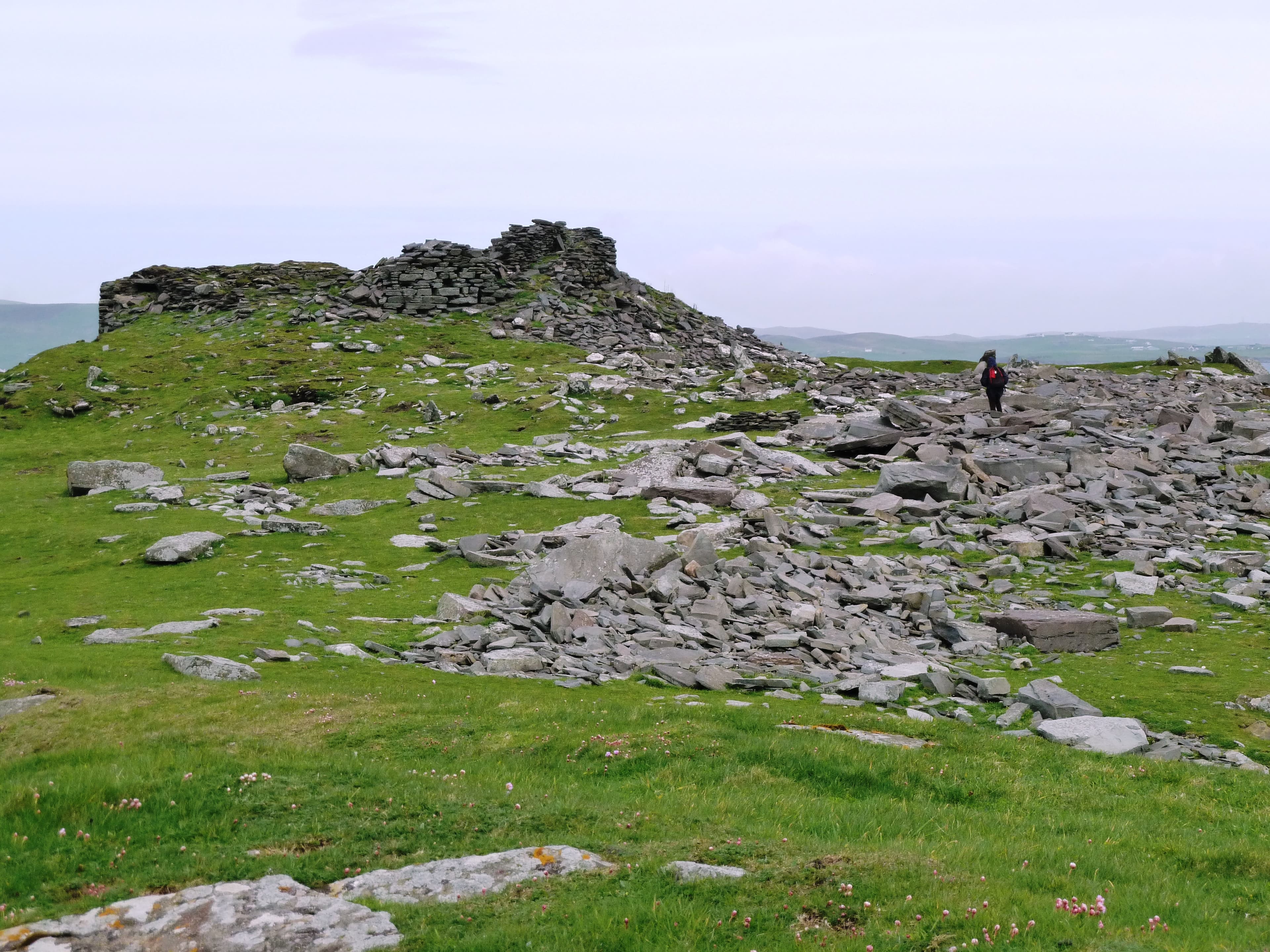
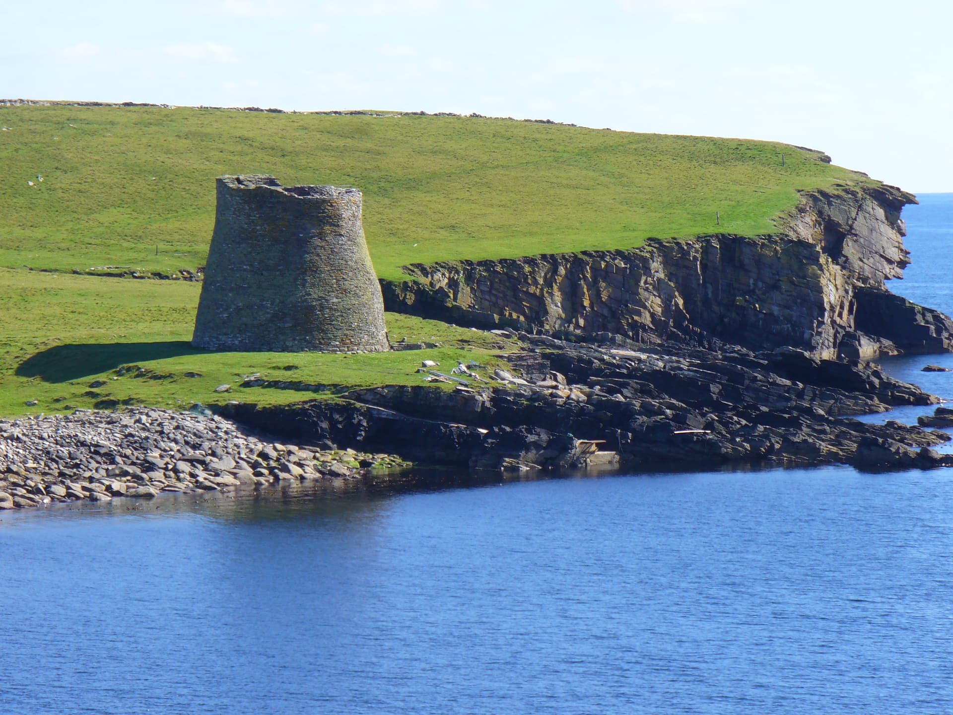
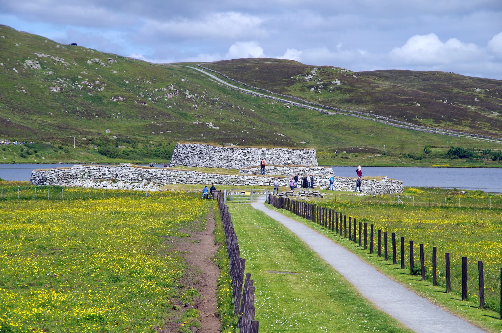
On the eastern coast of Mainland Shetland, the ruins of Burraland Broch stand on a promontory above Mousa Sound. Directly across the water, barely a kilometre away, rises the Broch of Mousa, the best-preserved broch in the world. Burraland is Mousa's counterpart, a paired tower that once faced its more famous neighbour across the narrow sound. While Mousa has survived almost intact, Burraland has weathered down to a substantial ruin, its outer walls still standing to over two metres on the seaward side and nearly four metres on the sheltered western face. The pairing of these two brochs, facing each other across open water, raises questions about territorial display, communal identity, and the social landscape of Iron Age Shetland.
Brochs were not isolated structures. Across Scotland, they frequently face each other across sounds, voes, and river valleys, creating visual pairings whose significance is debated but clearly intentional. Burraland and Mousa represent perhaps the most dramatic such pairing in Shetland: two towers separated by a kilometre of open water, each visible from the other, each commanding its own stretch of coast.
Burraland Broch was built probably between 500 BCE and 200 CE, during the same broad period as its counterpart on Mousa. The monument comprises the broch itself, two ramparts on the landward side providing additional defence, and the remains of several earth and stone structures, some of which are probably later buildings associated with post-broch occupation.
The broch is visible as a very large stone structure. The outer wall faces stand to over two metres on the exposed eastern side. On the western, sheltered side, the walls stand nearly four metres above the present ground surface. At this height, the overall diameter is at least seventeen metres and the wall thickness approaches three metres. The scale of construction is immediately impressive, though the ruin lacks the soaring completeness of the tower across the sound.
The relationship between Burraland and Mousa is central to understanding both sites. Were they built by the same community, one tower on the mainland and one on the island? Were they rival towers, competing for control of the sound? Were they sequential, one replacing the other? These questions cannot be answered from the surviving evidence, but the visual relationship between the two structures is unmistakable and invites reflection on the social world of Iron Age Shetland.
Burraland is one of approximately 130 known brochs in Shetland, part of a dense concentration of Iron Age monumental architecture that reflects the islands' prosperity and population during this period.
Context and lineage
No origin narrative survives for Burraland Broch. The builders' identity and cultural affiliations are unknown. The broch belongs to the wider tradition of monumental round tower construction that characterised Iron Age Scotland, particularly the north and the islands.
No continuous cultural tradition connects the present to the broch's Iron Age community. The structure has been a ruin for centuries. Its significance today lies in its architectural remains and its relationship to the Broch of Mousa.
Why this place is sacred
The thinness at Burraland is relational. The broch's power comes not only from its own antiquity and construction but from its dialogue across the water with Mousa. To stand at Burraland and look toward Mousa is to see two fates of the same architectural tradition: one tower fallen to ruin, the other still standing to its full height. The same builders, the same skills, the same materials, and yet radically different outcomes over two millennia.
This relationship raises questions about impermanence and persistence that extend beyond architecture into broader contemplation. What determines what survives? Mousa's exceptional preservation is attributed to its unusually massive construction and its island location, which protected it from stone-robbing. Burraland, on the mainland, was more accessible and therefore more vulnerable. The difference is largely a matter of location and thickness of walls, contingencies that determined which tower would endure.
The coastal setting contributes to the atmosphere. The sound between the two brochs is open water, frequented by seals, seabirds, and the boats that carry visitors to Mousa. The wind is constant. The light changes rapidly, especially in Shetland's long summer days when the sky never fully darkens. Standing at Burraland in the evening, watching the light play across Mousa's silhouette, is an experience that connects the viewer to the deep time of these structures and the elemental forces that have shaped their fate.
Burraland Broch served as a substantial Iron Age dwelling and probable territorial marker. The pairing with Mousa across the sound suggests a visual and social relationship between the two structures. The ramparts on the landward side indicate concern with defence. The associated structures suggest ongoing habitation beyond the broch's primary period of use.
The broch was constructed during the Iron Age and appears to have been occupied for an extended period. Later structures were built in association with the broch, suggesting continued habitation. The ruin has deteriorated over the centuries, with the exposed eastern face weathering more significantly than the sheltered western face.
Traditions and practice
Iron Age practices at the broch are inferred from the architecture and from regional parallels. The broch would have served as a dwelling, a storage facility, and a defensive position. The associated structures indicate a settlement that grew around the tower.
No organised practices take place. The site is visited by those exploring Shetland's archaeology, often in conjunction with the boat trip to Mousa.
Visit Burraland before or after your Mousa boat trip. Stand at the promontory and look across the sound to Mousa, considering the relationship between the two towers. Note the difference in preservation and reflect on what determines survival. The site rewards quiet observation and is a natural complement to the more dramatic experience of Mousa itself.
Iron Age Broch Culture (Atlantic Scotland)
HistoricalBurraland belongs to the broch-building tradition of Iron Age Scotland, a uniquely Scottish architectural achievement. The broch's position facing Mousa across the sound exemplifies the visual relationships between brochs that characterise the tradition across Shetland and the Scottish mainland. Over 130 brochs are known in Shetland alone, reflecting the islands' prosperity and population during the Iron Age.
The broch served as a dwelling, defensive position, and probable statement of territorial control. The ramparts on the landward side provided additional defence. The associated structures indicate a settlement that grew around the tower over time.
Experience and perspectives
The approach to Burraland Broch follows the coast of Mainland Shetland near Sandwick, the same village from which boats depart for Mousa. The broch sits on a promontory, its ruined walls clearly visible as you approach.
The first impression is of scale. Although Burraland lacks the towering completeness of Mousa, it is a substantial structure. The walls on the western side rise nearly four metres, giving a clear sense of the broch's original mass. The outer faces are rough with age, the stones grey and lichen-covered, but the construction technique is still readable: carefully coursed drystone work without mortar.
Walking around the exterior, you encounter the two ramparts on the landward side, defensive works that would have controlled access from the mainland. Between the ramparts and the broch, the remains of later structures are visible, evidence of a settlement that grew around the tower over time.
The view across Mousa Sound is the defining experience. From Burraland, Mousa Broch is clearly visible on the low island across the water. Its silhouette, rising to thirteen metres, is unmistakable. The visual pairing of the two structures, ruin facing perfection, mainland facing island, creates a spatial relationship that must have been as significant to the Iron Age inhabitants as it is evocative to modern visitors.
The coastal environment adds to the experience. Seals often haul out on the rocks below. Seabirds, including the storm petrels that nest in Mousa's walls, cross the sound. The wind carries the sound of the sea. In the long light of Shetland summer evenings, the scene acquires a quality of timelessness that few locations in the British Isles can match.
Burraland Broch is located near Sandwick on the eastern coast of Mainland Shetland. The site is accessible from the road that leads to the Mousa Boat departure point. A short walk from the road leads to the promontory. Combine with a visit to the Broch of Mousa, accessible by boat from Sandwick during the April to September season.
Burraland Broch's significance lies primarily in its relationship to the Broch of Mousa and what that relationship reveals about Iron Age social organisation in Shetland. The pairing of the two brochs across Mousa Sound is one of the clearest examples of the visual relationships between brochs that scholars have identified across Scotland.
Scholars have noted that brochs frequently face each other across sounds, voes, and river valleys, suggesting that visual display and territorial signalling were important functions of these structures. Burraland and Mousa represent perhaps the most dramatic such pairing in Shetland. The close proximity of the two brochs supports theories about competitive display, communal identity, and the social organisation of Iron Age communities. Whether the two towers were contemporary, sequential, or served complementary functions is not established. Burraland is one of approximately 130 known brochs in Shetland.
No oral traditions survive specifically for Burraland Broch. The broader tradition of broch-building in Shetland is understood through archaeological evidence rather than literary or oral sources.
Some visitors interpret the pairing of Burraland and Mousa in terms of energy lines or sacred geometry. The facing relationship across water has attracted comparison to paired temples or standing stones in other traditions. These interpretations have no archaeological support but reflect the visual impact of the site.
The relationship between Burraland and Mousa, whether complementary, competitive, or sequential, is not understood. The exact dates of construction and occupation cannot be determined without further excavation. The identity and social organisation of the builders remain unknown. What specific role, if any, the broch played in ceremonies, trade, or territorial control is a matter of speculation.
Visit planning
Located near Sandwick on the eastern coast of Mainland Shetland, approximately 15 km south of Lerwick. Accessible from the road leading to the Mousa Boat departure point at Sandsayre. A short walk from the road leads to the promontory. To reach Shetland: NorthLink Ferries from Aberdeen or flights to Sumburgh Airport. Bus services connect Lerwick to the Sandwick area.
Accommodation available in the Sandwick area and more extensively in Lerwick.
Burraland Broch is an archaeological site on open ground. Basic respect for the monument and the coastal environment is expected.
Warm, waterproof clothing and sturdy footwear. Shetland weather is changeable and the coastal position is exposed.
Photography is unrestricted. The view across Mousa Sound to Mousa Broch is particularly photogenic.
Do not leave offerings at the site.
Do not disturb, damage, or remove any material from the scheduled monument. Stay back from cliff edges.
Plan your visit
Address
Sndwick, Mainland, Sandwick ZE2 9HW, UK
Hours
Hours, fees, and access can change — verify on the official source before you travel. Practical details last checked Jun 2026.
Nearby sacred places
Sacred places within a half-day’s reach. Pilgrims often visit them together: walk one, stay for the other.
Key questions
What pilgrims usually ask
- Why is Burraland Broch considered sacred?
- Discover Burraland Broch in Shetland, the mainland counterpart to the world-famous Broch of Mousa. Iron Age tower ruins on the coast of Mainland Shetland.
- What should I wear at Burraland Broch?
- Warm, waterproof clothing and sturdy footwear. Shetland weather is changeable and the coastal position is exposed.
- Can I take photos at Burraland Broch?
- Photography is unrestricted. The view across Mousa Sound to Mousa Broch is particularly photogenic.
- How long should I spend at Burraland Broch?
- One hour to explore the broch, ramparts, and associated structures and absorb the coastal setting.
- How do you visit Burraland Broch?
- Located near Sandwick on the eastern coast of Mainland Shetland, approximately 15 km south of Lerwick. Accessible from the road leading to the Mousa Boat departure point at Sandsayre. A short walk from the road leads to the promontory. To reach Shetland: NorthLink Ferries from Aberdeen or flights to Sumburgh Airport. Bus services connect Lerwick to the Sandwick area.
- What offerings are appropriate at Burraland Broch?
- Do not leave offerings at the site.
- What etiquette should visitors follow at Burraland Broch?
- Burraland Broch is an archaeological site on open ground. Basic respect for the monument and the coastal environment is expected.
- What is the history of Burraland Broch?
- No origin narrative survives for Burraland Broch. The builders' identity and cultural affiliations are unknown. The broch belongs to the wider tradition of monumental round tower construction that characterised Iron Age Scotland, particularly the north and the islands.