Culswick Broch
A red granite tower on the Atlantic edge, where Iron Age builders claimed the horizon as their own
Walls, United Kingdom
Plan this visit
Practical context before you go
3 hours (walk in, explore broch and immediate surroundings, walk out)
Respect the scheduled monument status. Walk carefully on ancient stonework. Leave nothing behind. Take nothing away.
At a glance
- Coordinates
- 60.1869, -1.5442
- Type
- Broch
- Suggested duration
- 3 hours (walk in, explore broch and immediate surroundings, walk out)
Pilgrim tips
- Shetland weather demands preparation at any time of year. Waterproof and windproof outer layers are essential. The moorland walk requires waterproof hiking boots with ankle support, as the ground is uneven with boggy sections. Layers are advisable, as conditions shift quickly between sunshine, wind, and rain. In summer, midges can be present on the moorland in calm conditions. In winter, full hill-walking equipment is appropriate for this exposed terrain.
- Photography is freely permitted and encouraged. The red granite of the broch photographs with particular warmth in morning or evening light. The triangular lintel stone entrance provides a natural frame. Panoramic views from beside the broch are exceptional in every direction. The Burga Stacks to the south and Foula on the western horizon are particularly striking subjects. In summer, the extended twilight of the simmer dim creates hours of soft golden light.
- The moorland walk includes boggy sections and pathless terrain. Waterproof hiking boots are essential. Shetland weather changes rapidly; carry waterproof layers regardless of conditions at the start. There is no phone signal at the broch. The site is remote with no facilities. The broch interior is filled with rubble from collapse and should not be climbed on. Cliff edges near the broch are unguarded and dangerous, particularly in wind. As a Scheduled Ancient Monument, any disturbance of the stonework or ground is illegal.
Overview
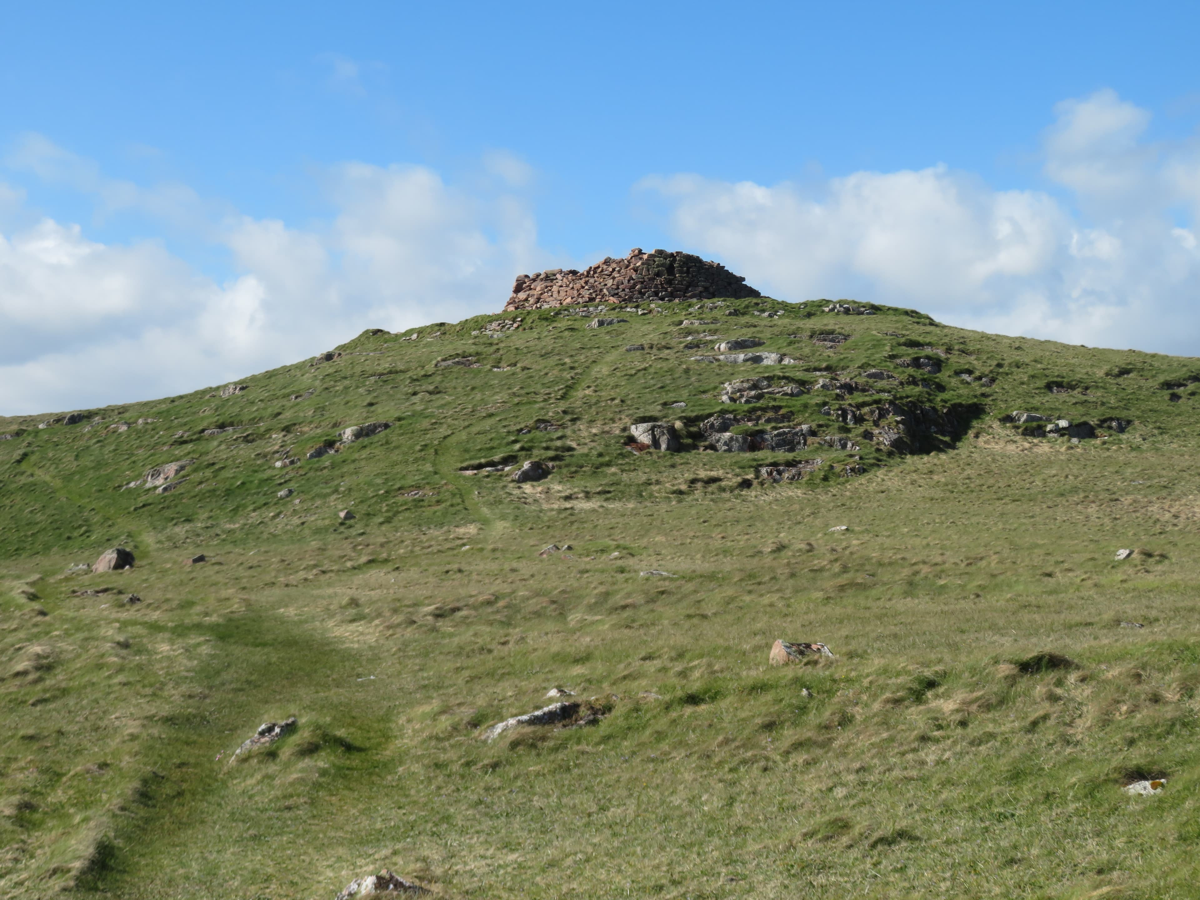
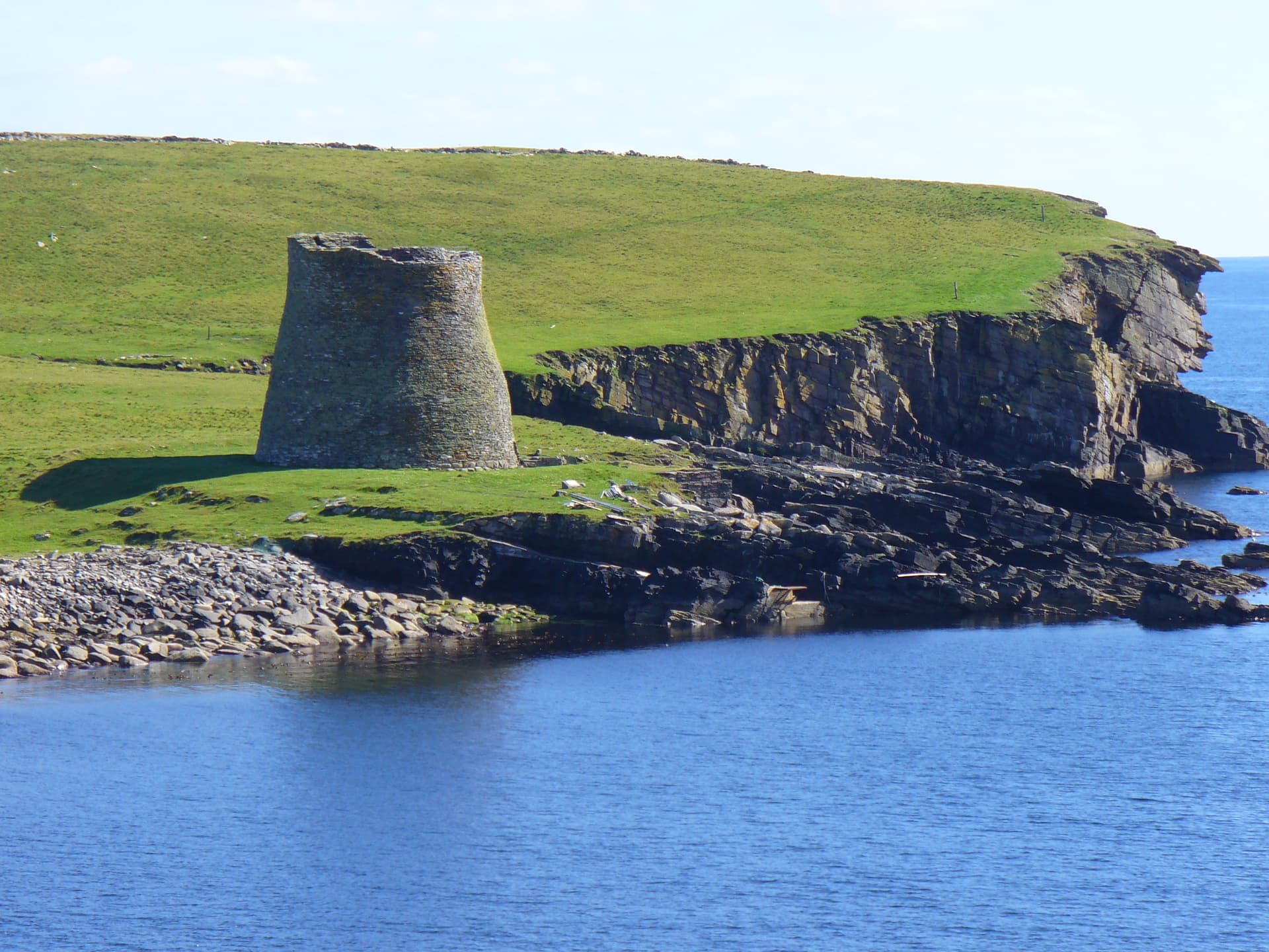
On a conical hilltop above the western coast of Shetland, the walls of Culswick Broch still stand in local red granite, warm-coloured and resolute after two thousand years. Reached only by a moorland walk of three miles round trip, the broch rewards the journey with some of the finest panoramic views in the islands. Foula, Vaila, the Burga Stacks, and the open Atlantic spread in every direction. The walk itself becomes the experience, passing abandoned settlements and crossing rough ground where no path exists.
There is no shortcut to Culswick Broch. You park near a telephone box in the scattered hamlet of Culswick, on Shetland's West Mainland, and you walk. The route crosses open moorland, skirts the shore of the Loch of Sotersta, passes the stone ruins of an abandoned settlement, and arrives at a conical hill rising forty-five metres above the sea. On its summit, built from the red granite that gives the headland its character, stands a broch tower that has occupied this position since somewhere between 500 BC and AD 200.
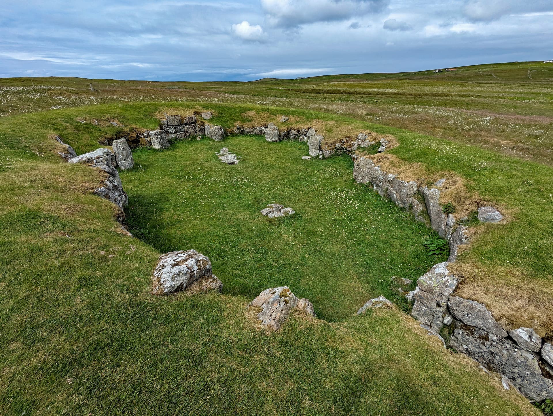
The structure is substantial even in its reduced state. Walls averaging over four metres thick enclose a circular interior roughly sixteen metres across externally. A distinctive triangular lintel stone marks the entrance, an architectural choice that may be structural, symbolic, or both. George Low sketched the broch in 1774 and recorded it standing twenty-three feet high with three intramural galleries visible between the double walls. Today the walls reach approximately three metres, diminished by centuries of stone robbing and Atlantic weather, but still imposing in their mass and precision.
What makes Culswick extraordinary is not the broch alone but its relationship with the landscape. The hilltop position commands views that stretch to Foula, one of Britain's most remote inhabited islands, visible as a dark outline on the western horizon. To the south, the Burga Stacks rise from the sea, associated with a legend of an early Christian hermit who lived on the rock and received supplies hauled up in a bucket. Below the broch, the Loch of Brough lies still and dark. The Atlantic presses against the cliffs. The sky, at sixty degrees north, occupies more of your visual field than in almost any other inhabited place in Europe. The Iron Age builders who chose this site understood the power of a position that claims the horizon in every direction.
Context and lineage
Sometime during the Iron Age, between roughly 500 BC and AD 200, a community chose this conical hilltop above the Atlantic coast as the site for a broch tower. The choice of location was deliberate and strategic. The hill commands views in every direction, covering sea approaches from the west and south, the entrance to Gruting Voe to the north, and the moorland hinterland to the east. A defensive rampart was built around the base of the hill, creating an outer enclosure.
The builders quarried local red granite, a stone that gives the broch its distinctive warm colour and that weathers with particular resilience. They constructed walls over four metres thick in double-wall technique, with a cavity between the inner and outer skins that contained galleries and staircases. The entrance was framed with a massive triangular lintel stone, an unusual architectural feature that may have been structural, decorative, or ritually significant. At its full height, the broch rose at least seven metres, possibly higher, a visible statement of power that could be seen from considerable distances across the open landscape.
The broch was part of a much larger tradition. Over five hundred brochs are known across Scotland, with more than one hundred and twenty in Shetland alone. They represent the most sophisticated monumental architecture of Iron Age Atlantic Scotland, and their purpose, while debated, clearly combined the practical with the symbolic. A broch was a home, a fortress, and a marker of territorial authority.
Culswick Broch belongs to the Atlantic Scottish broch-building tradition, a monumental architectural form unique to Scotland and concentrated in the Northern and Western Isles, Caithness, and Sutherland. Shetland contains over one hundred and twenty broch sites, the densest concentration in Scotland. The tradition flourished between approximately 500 BC and AD 200. The best-preserved example, Mousa Broch on the east coast of Shetland, still stands to its full height of over thirteen metres and gives an indication of what Culswick may once have looked like. Within the wider landscape, the broch sits near Staneydale Temple, a Neolithic structure approximately four thousand years old, and is within the same cultural orbit as the great multi-period sites of Jarlshof and Clickimin further south. The nearby Burga Stacks, associated with an Early Christian hermitage tradition, suggest that this stretch of coastline continued to attract people seeking remote, contemplative positions long after the broch was abandoned.
George Low
Skene
RCAHMS
Why this place is sacred
The thinness of Culswick begins long before you reach the broch. It begins with the walk. There is no casual way to arrive here. The moorland crossing requires intention, physical effort, and attention to the ground beneath your feet. Boggy hollows, tussock grass, the stony dam at the outflow of the Loch of Brough where you must pick your way across. The landscape does not accommodate you. It requires you to meet it on its terms.
This is by design, if not by the broch builders then by the landscape itself. The approach strips away distraction. Your phone signal faded a mile back. There is no one else here. The sound environment narrows to wind, water, and the occasional call of a bonxie or a curlew. By the time you reach the base of the conical hill and begin the final climb, you have been walking for forty minutes or more, and the modern world has become genuinely remote.
Then the broch appears. Not suddenly but by degrees, its red granite walls emerging against the sky as you gain elevation. The colour matters. In sunlight, the stone glows with a warmth that seems almost organic, earning the broch its description as a red beacon on the headland. Against the grey-green moorland and the steel-blue Atlantic, the colour is startling. You are looking at stone that was quarried, shaped, and stacked by hands that understood this particular granite, this particular hill, this particular view.
The entrance intensifies the threshold. The triangular lintel stone frames a doorway that has been stepped through for two millennia. To pass through it is to cross the same boundary that every person who entered this broch has crossed. The form of the doorway is unusual and specific. It was not the only way to frame an entrance. Someone chose this shape. The choice persists.
Beyond the walls, the view opens again, and this is the final thinning. You stand where Iron Age people stood, looking at the same ocean, the same islands, the same sky. The landscape has not changed in any way that matters. Foula was there. The stacks were there. The Atlantic pressed the same cliffs. The continuity is not metaphorical. It is geological, geographical, actual. Two thousand years of human absence have altered nothing in the view. What has changed is only the species of attention you bring to it.
Culswick Broch served as a defensive and high-status domestic structure during the Iron Age, part of the Atlantic Scottish broch-building tradition. The monumental scale of the tower, its commanding hilltop position, and the surrounding rampart all indicate that the site projected authority and territorial control over the surrounding landscape and sea approaches. Brochs were not merely practical. Their visibility across the landscape made them symbols of power and permanence, statements that this place and the territory visible from it belonged to the community that built and maintained the tower.
The broch was first documented by George Low during his tour of Shetland in 1774, when he sketched the structure still standing twenty-three feet high with three visible galleries. By 1805, when Skene made drawings, the structure was still relatively well preserved. The RCAHMS surveyed the broch by plane-table in June 1931, recording significant deterioration. The site was first scheduled as an ancient monument in 1934, acknowledging its national importance. It was rescheduled in 2012 with updated documentation by Historic Environment Scotland. The broch has never been excavated, meaning the interior remains a sealed archaeological deposit, its secrets preserved beneath the rubble of collapse. The surrounding settlement and field systems visible along the walking route, including the abandoned township of Sotersta, represent later phases of human occupation in this landscape, adding layers of historical memory to the approach.
Traditions and practice
No specific rituals or ceremonies have been documented for Culswick Broch. As an unexcavated site, the internal activities of its Iron Age inhabitants remain unknown. Brochs in general are understood as defensive and high-status domestic structures, though their monumental architecture and commanding positions suggest they held symbolic importance beyond practical function. The nearby Burga Stacks carry a tradition of Early Christian monastic retreat, with a hermit said to have lived on one of the sea stacks, receiving supplies by bucket. Whether this represents historical fact or later legend is debated, but the tradition suggests that the contemplative potential of this coastline has been recognised for centuries.
No active ceremonial or spiritual practices take place at the site. Culswick Broch functions as an open-access Scheduled Ancient Monument visited primarily by walkers and those with interest in archaeology and history. The walk itself has become a valued experience in the Shetland walking community, frequently described as one of the finest short walks in the islands.
The walk to Culswick Broch is inherently contemplative. The absence of a formal path for much of the route, the lack of phone signal, the emptiness of the moorland, and the physical effort required all contribute to a natural stripping away of distraction. Allow this process to work. Do not rush.
At the ruined settlement of Sotersta, pause among the abandoned stone walls. These are the remains of a community that lived and farmed here until relatively recently. Consider the layers of habitation in this landscape: the broch builders two thousand years ago, the Sotersta families a few generations ago, you now.
At the broch entrance, stand before the triangular lintel stone. This is not a standard architectural form. It was chosen or developed by the builders, and it has defined the threshold of this place for two millennia. Step through slowly. Notice the thickness of the walls on either side of you, over four metres of carefully stacked stone.
Inside, do not attempt to climb the rubble. Stand at the perimeter and look up at the remaining wall height. Then look outward. The views are the broch's gift. The Iron Age inhabitants saw the same ocean, the same islands, the same sky. Sit with your back against the outer wall if conditions allow, facing west toward Foula, and simply be present in the same position that people have occupied since the Iron Age.
If conditions and time allow, walk south from the broch toward the cliff edge for a view of the Burga Stacks. The sea stacks carry the memory of a hermit who chose this place for solitary contemplation. The impulse to seek out remote, elevated, ocean-facing positions for reflection is older than any doctrine.
Iron Age Broch Culture
HistoricalCulswick Broch belongs to the Atlantic Scottish broch-building tradition that flourished between approximately 500 BC and AD 200. With over one hundred and twenty brochs in Shetland alone and more than five hundred across Scotland, these monumental drystone towers represent the most sophisticated architectural achievement of Iron Age northern and western Scotland. The brochs combined defensive functionality with symbolic projections of power and social status. Culswick is one of the best-preserved examples in Shetland, with its distinctive triangular lintel stone and massive double walls demonstrating the considerable skill of Iron Age builders working with local red granite.
Defensive habitation and community focal point. Brochs served as high-status residences, their single entrance and windowless walls providing security. The surrounding rampart at Culswick and the strategic hilltop position indicate control over the surrounding landscape and sea approaches. Daily life within the broch would have centred on a hearth at ground level, with upper floors accessed by staircases within the wall cavity.
Early Christian Hermitage (Burga Stacks)
HistoricalThe Burga Stacks, sea stacks visible from the broch to the south, are associated with a legend of a monk or hermit who lived on one of the stacks and received supplies hauled up in a bucket. Scholarly analysis suggests this may represent a solitary desert retreat following Early Christian monastic practices, echoing the eighth-century Rule of Columcille regarding monks seeking solitary meditation. The tradition connects this coastline to a broader pattern of early Christian hermit sites on remote Atlantic stacks and islands.
Solitary Christian monastic meditation and retreat. The extreme isolation and exposure of a sea stack created conditions of voluntary hardship and detachment from worldly concerns, consistent with the ascetic traditions of early Celtic Christianity.
Experience and perspectives
Begin at the parking area near the telephone box in Culswick hamlet. A small sign points toward Culswick Methodist Chapel, and the track leads west past a few houses before opening onto moorland. The ground is rough from the start, a mix of grass, heather, and peat. In wet weather, sections near the Loch of Sotersta become genuinely boggy, requiring careful footwork.
After fifteen minutes, the ruined settlement of Sotersta appears to your left. Stone walls and enclosures mark where families lived and farmed within living memory. The walls are tumbling but still legible, roofless houses and animal pens arranged along the contour of the hill. Pause here. The poignancy of this abandoned place prepares you for the broch. Human habitation in this landscape is not permanent. It comes and goes across centuries and millennia. The people of Sotersta left. The people of the broch left before them.
Continue west. The path, such as it is, descends toward the Loch of Brough. At the loch's outflow, a stony dam provides a crossing point, though in high water you may get wet feet. Beyond the loch, the ground rises toward the headland, and the broch comes into view on its conical hill, the red granite distinct against the sky.
The final climb is steep but short. The surrounding rampart is visible as a low earthwork encircling the broch at a distance of three to eight metres. The entrance faces you as you approach from the east, the massive triangular lintel stone framing the doorway. Step through. The walls rise around you, still reaching three metres and more, their inward batter giving the interior a sense of containment. The double-wall construction is visible in places, the cavity between the inner and outer walls once holding galleries and staircases that allowed the builders to reach the upper levels.
The interior is largely filled with rubble from the collapse of the upper storeys. Do not climb on it. Instead, stand at the edge and look up. Imagine the space as it was: a tower rising seven metres or more, internal wooden floors supported by scarcement ledges in the stone, a central hearth whose smoke rose through the levels, the entrance the only source of natural light. Then turn outward. The views from beside the broch walls are extraordinary in every direction. West to Foula, south to the Burga Stacks and the cliffs of Westerwick, north across Gruting Voe, east back across the moorland you have just crossed.
The Burga Stacks deserve attention. Two sea stacks rising from the water to the south, one of them associated with the legend of an early Christian hermit. A monk, the story goes, lived on the rock and received provisions hauled up in a bucket. Whether this is historical memory or later invention is unknown. But the tradition places solitary contemplation in this landscape long before the concept had a name.
The walk back follows the same route. The return journey, with the broch behind you and the modern world gradually reasserting itself, provides its own kind of contemplation. The transition from the ancient to the contemporary is as gradual as the transition out.
Culswick Broch sits atop a conical hill on the Atlantic coast of Shetland's West Mainland, approximately 1.5 miles west of Culswick hamlet. The broch is oriented with its entrance facing roughly east, toward the approaching walker. The Loch of Brough lies to the east below the hill. The Burga Stacks are visible to the south across the water. Foula lies on the western horizon. Gruting Voe is to the north.
Culswick Broch is understood primarily through its visible archaeology, historical documentation, and its place within the wider broch-building tradition of Atlantic Scotland. The site has never been excavated, which means scholarly understanding rests on surface observation, comparative analysis, and the documentary record beginning with George Low's 1774 visit.
Historic Environment Scotland recognises Culswick as a Scheduled Ancient Monument of national importance for its potential to contribute to understanding of Iron Age Shetland and the role and function of brochs. The site was first surveyed systematically by RCAHMS in 1931 and first scheduled in 1934. George Low's 1774 sketch is a particularly valuable historical document, recording the broch standing at twenty-three feet with three complete intramural galleries, significantly taller than its current state. This implies substantial stone robbing occurred during the late 18th and 19th centuries, likely for use in local agricultural buildings. The construction date is estimated between 500 BC and AD 200, consistent with the broader broch-building period. The double-wall construction with galleries, the inward-battering walls, and the surrounding rampart are all features typical of the Atlantic Scottish broch tradition. The triangular lintel stone entrance is noted as a distinctive feature. As an unexcavated site, Culswick retains its full archaeological potential, and any future excavation could significantly advance understanding of Iron Age life in western Shetland.
The broch has never been excavated, meaning the interior remains a sealed archaeological deposit. The precise construction date, the nature of internal arrangements, the identity of the builders, and the reasons for the eventual abandonment are all unknown. The purpose of the distinctive triangular lintel stone, whether purely structural or carrying symbolic or ritual significance, is debated. The relationship between the broch and the Early Christian hermitage tradition on the nearby Burga Stacks raises an intriguing question: was there continuity of significance in this landscape across the centuries, or are these unrelated occupations separated by long stretches of abandonment? The extent and nature of the surrounding rampart, and whether additional structures existed within or beyond it, await excavation to determine. The degree of stone robbing and when it occurred can only be partly inferred from the gap between Low's 1774 description and the current state.
Visit planning
The nearest accommodation is in the village of Walls, approximately five miles north, which has a small number of B&Bs and self-catering options. Lerwick, twenty-five miles east, offers the full range of accommodation from hotels to hostels. Shetland is reached by NorthLink ferry from Aberdeen or Orkney, or by air to Sumburgh Airport from several Scottish cities.
Respect the scheduled monument status. Walk carefully on ancient stonework. Leave nothing behind. Take nothing away.
Shetland weather demands preparation at any time of year. Waterproof and windproof outer layers are essential. The moorland walk requires waterproof hiking boots with ankle support, as the ground is uneven with boggy sections. Layers are advisable, as conditions shift quickly between sunshine, wind, and rain. In summer, midges can be present on the moorland in calm conditions. In winter, full hill-walking equipment is appropriate for this exposed terrain.
Photography is freely permitted and encouraged. The red granite of the broch photographs with particular warmth in morning or evening light. The triangular lintel stone entrance provides a natural frame. Panoramic views from beside the broch are exceptional in every direction. The Burga Stacks to the south and Foula on the western horizon are particularly striking subjects. In summer, the extended twilight of the simmer dim creates hours of soft golden light.
Not traditionally associated with offerings. As a Scheduled Ancient Monument, visitors should not leave objects at the site. The most appropriate offering is careful attention and the willingness to make the walk.
Do not climb on, disturb, or remove any stonework. Do not dig or probe the ground. As a Scheduled Ancient Monument, any unauthorized disturbance is illegal under Scottish law. Take care near cliff edges, which are unguarded and subject to erosion. Do not light fires. Leave no trace.
Plan your visit
Address
Mainland,, Shetland ZE2 9NL, UK
Hours
Hours, fees, and access can change — verify on the official source before you travel. Practical details last checked Jun 2026.
Nearby sacred places
Sacred places within a half-day’s reach. Pilgrims often visit them together: walk one, stay for the other.
References
Sources consulted when researching this page. Independent verification by readers is welcome.
- 01Broch of Culswick (SM2055) — Historic Environment Scotlandhigh-reliability
- 02Broch Of Culswick (Site 337) — Canmore (RCAHMS)high-reliability
- 03The Burri Stacks of Culswick, Shetland, and other paired stack-settlements — Proceedings of the Society of Antiquaries of Scotlandhigh-reliability
- 04Broch of Culswick — Wikipedia
- 05Broch of Culswick, Shetland West, Shetland Islands — Ancient Monuments UK
- 06Culswick Broch — The Megalithic Portal
- 07A walk to Culswick Broch in Shetland — NorthLink Ferries
- 08Culswick Broch and the Burga Stacks, Culswick — WalkHighlands
- 09Culswick Broch walk: Shetland's West Mainland — Shetland With Laurie
- 10A walk to Culswick Broch — Shetland.org
Key questions
What pilgrims usually ask
- Why is Culswick Broch considered sacred?
- Walk the moorland to Culswick Broch in Shetland. A 2,000-year-old Iron Age red granite tower with panoramic Atlantic views to Foula. Free access, 3-mile walk.
- What should I wear at Culswick Broch?
- Shetland weather demands preparation at any time of year. Waterproof and windproof outer layers are essential. The moorland walk requires waterproof hiking boots with ankle support, as the ground is uneven with boggy sections. Layers are advisable, as conditions shift quickly between sunshine, wind, and rain. In summer, midges can be present on the moorland in calm conditions. In winter, full hill-walking equipment is appropriate for this exposed terrain.
- Can I take photos at Culswick Broch?
- Photography is freely permitted and encouraged. The red granite of the broch photographs with particular warmth in morning or evening light. The triangular lintel stone entrance provides a natural frame. Panoramic views from beside the broch are exceptional in every direction. The Burga Stacks to the south and Foula on the western horizon are particularly striking subjects. In summer, the extended twilight of the simmer dim creates hours of soft golden light.
- How long should I spend at Culswick Broch?
- 3 hours (walk in, explore broch and immediate surroundings, walk out)
- What offerings are appropriate at Culswick Broch?
- Not traditionally associated with offerings. As a Scheduled Ancient Monument, visitors should not leave objects at the site. The most appropriate offering is careful attention and the willingness to make the walk.
- What etiquette should visitors follow at Culswick Broch?
- Respect the scheduled monument status. Walk carefully on ancient stonework. Leave nothing behind. Take nothing away.
- What is the history of Culswick Broch?
- Sometime during the Iron Age, between roughly 500 BC and AD 200, a community chose this conical hilltop above the Atlantic coast as the site for a broch tower. The choice of location was deliberate and strategic. The hill commands views in every direction, covering sea approaches from the west and south, the entrance to Gruting Voe to the north, and the moorland hinterland to the east. A defensive rampart was built around the base of the hill, creating an outer enclosure. The builders quarried local red granite, a stone that gives the broch its distinctive warm colour and that weathers with particular resilience. They constructed walls over four metres thick in double-wall technique, with a cavity between the inner and outer skins that contained galleries and staircases. The entrance was framed with a massive triangular lintel stone, an unusual architectural feature that may have been structural, decorative, or ritually significant. At its full height, the broch rose at least seven metres, possibly higher, a visible statement of power that could be seen from considerable distances across the open landscape. The broch was part of a much larger tradition. Over five hundred brochs are known across Scotland, with more than one hundred and twenty in Shetland alone. They represent the most sophisticated monumental architecture of Iron Age Atlantic Scotland, and their purpose, while debated, clearly combined the practical with the symbolic. A broch was a home, a fortress, and a marker of territorial authority.
- Who is associated with Culswick Broch?
- George Low, Skene, RCAHMS