Puig de sa Morisca
A fortified Bronze Age village above the Bay of Santa Ponça
Calvià, Calvià, Mallorca, Spain

Plan this visit
Practical context before you go
Approximately 1–2 hours to see the exhibition and walk the main trails; the full 8-kilometer trail network with all five viewpoints would take longer.
The park is reached via the Palma–Andratx road near Santa Ponça, with a car park and waymarked trails; the address is given as C/ Puig de sa Morisca, s/n, 07180, Calvià (also listed as C/ Puig de na Morisca, 17). Paved pathways and ramps exist in parts of the park, but overall wheelchair accessibility is limited by the natural, hilly terrain. No mobile phone signal information was available at time of writing; check the Ajuntament de Calvià heritage website (calvia.com) for current details. No specific keyholder or advance-booking requirement is documented — access is described as free and unrestricted year-round — but visitors seeking guided interpretation or the exhibition building's opening hours should consult the Ajuntament de Calvià heritage website (calvia.com) directly; sourced material did not confirm a specific tourist-office phone number or email for this park.
The park has no formal dress code or entry ritual; the operative etiquette is physical restraint around the stone structures themselves.
At a glance
- Coordinates
- 39.5075, 2.4811
- Type
- Talayotic Settlement
- Suggested duration
- Approximately 1–2 hours to see the exhibition and walk the main trails; the full 8-kilometer trail network with all five viewpoints would take longer.
- Access
- The park is reached via the Palma–Andratx road near Santa Ponça, with a car park and waymarked trails; the address is given as C/ Puig de sa Morisca, s/n, 07180, Calvià (also listed as C/ Puig de na Morisca, 17). Paved pathways and ramps exist in parts of the park, but overall wheelchair accessibility is limited by the natural, hilly terrain. No mobile phone signal information was available at time of writing; check the Ajuntament de Calvià heritage website (calvia.com) for current details. No specific keyholder or advance-booking requirement is documented — access is described as free and unrestricted year-round — but visitors seeking guided interpretation or the exhibition building's opening hours should consult the Ajuntament de Calvià heritage website (calvia.com) directly; sourced material did not confirm a specific tourist-office phone number or email for this park.
Pilgrim tips
- No dress code is specified in sourced material; sturdy walking shoes are recommended given the uneven, rocky terrain and the hill climb involved.
- No photography restrictions were found in sourced material.
- Do not climb on the tower or dwelling structures, and do not remove or handle loose stones — both were explicitly flagged by the Guardia Civil's Nature Protection unit after the 2025 damage to Tower III's restored column and a replica Iron Age smelting oven.
Overview
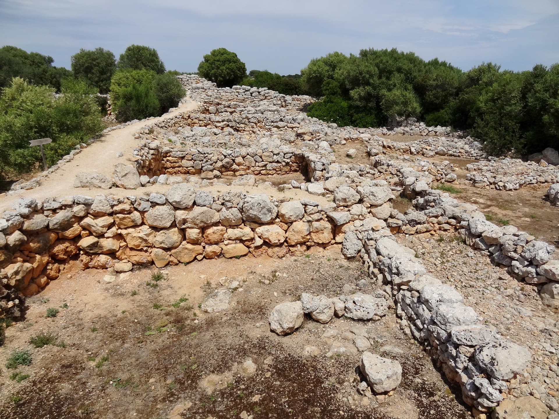
Puig de sa Morisca is a hilltop archaeological park in Calvià, Mallorca, preserving a Talayotic settlement founded around 1300 BCE and later reoccupied by Roman and Islamic communities. Visitors walk marked trails past defensive towers, dwellings, and a burial site, with views over the Bay of Santa Ponça.
On a 120-meter hill overlooking the Bay of Santa Ponça, the stones of Puig de sa Morisca record roughly two and a half thousand years of continuous human presence. The oldest walls date to the Late Bronze Age, around 1300 BCE, when a Talayotic community — part of the prehistoric culture unique to the Balearic Islands — built a village on this exposed, defensible rise. Fortification intensified in the Iron Age, when a circular tower was raised to guard the settlement's approach. Centuries later, Roman-era occupants left traces of contact with Punic traders, and an Islamic Almohad-period community built anew on the same ground before the site's final abandonment. What survives today is not one structure but a layered settlement: dwelling foundations, a fortified tower, a burial site known as the Tomb of Son Ferrer, and later charcoal-burners' huts from the island's forestry era, all set inside a protected park of pine and Mediterranean scrub. Since its designation as an archaeological park in 2002, the site has functioned less as a monument to a single moment than as a physical timeline — a place where the transitions of an island, from prehistoric fortification to Christian conquest, are legible underfoot.
Context and lineage
No foundation legend survives; the site's origin is known only archaeologically. The earliest occupation layer dates to the Late Bronze Age, approximately 1300 BCE, when a Talayotic community established a settlement on the hill. Fortification, including a circular defensive tower, was added during the Iron Age, around 900–800 BCE.
No single lineage of builders can be traced; the site instead shows sequential occupation by unrelated cultures — Talayotic, Roman-period/Punic-contact, and Islamic Almohad — each adapting the same hilltop to its own defensive and residential needs.
Why this place is sacred
There is no evidence that Puig de sa Morisca was ever a place of worship in the way a temple or shrine would be; its importance lies in what it demonstrates about how people used this specific hill across very different eras. A Late Bronze Age community chose it first, likely for the same reasons any hilltop position recommends itself — visibility of the coastline, defensibility, and control of the routes below. That original choice proved durable: the Iron Age fortification phase built on it rather than starting over, and centuries later, Roman-period inhabitants and then an Islamic Almohad community did the same. The site's Punic-influenced ceramic finds suggest the settlement operated as a point of contact and exchange between the indigenous Talayotic population and wider Mediterranean trade networks, rather than as an isolated redoubt. Its final historical distinction — as the reported site of the first battle in the Christian conquest of Mallorca — marks the point where this long sequence of continuous habitation ends and the hill's active life becomes archaeological memory rather than lived history.
A fortified Talayotic village and, in later periods, a Roman-contact and then Islamic settlement occupying the same defensible hilltop.
Late Bronze Age settlement (c. 1300 BCE) → Iron Age fortification with circular tower (c. 900–800 BCE) → reduced defensive need and village expansion beyond the walls (3rd century BCE) → Roman-period and Punic-trade contact → Islamic Almohad-period settlement → abandonment sometime between late antiquity and the Almohad period (exact date not established in sourced material) → later use of the hill by charcoal-burners (barracas de roters) → designation as a protected archaeological park in 2002, following a 1997 research partnership between the University of the Balearic Islands and Calvià Town Hall.
Traditions and practice
No ceremonial or ritual practices from the Talayotic, Roman-contact, or Islamic occupation phases are documented in the sourced material. What is known is functional: fortification, dwelling, trade, and — in the case of the Son Ferrer tomb — burial.
The site is maintained as a public archaeological park with a permanent exhibition, 'Humans in Contact,' housed in a 1,700 m² building that displays finds from over sixty years of municipal excavation. Ongoing conservation work followed the 2025 vandalism of Tower III, whose central column had previously been restored in 2006.
Walk the marked trail at a deliberate pace rather than making straight for the summit viewpoint. At the tower and dwelling foundations, pause before moving on: notice how the stonework uses the natural streambed and rock outcrops rather than working against them, and how the tower's position controls the sightline down toward the bay. Let the climb and the ruins register as one continuous piece of terrain shaped by people, rather than a set of separate stops.
Talayotic Culture
HistoricalPuig de sa Morisca preserves one of the most important known Talayotic settlements in the municipality of Calvià, with continuous occupation from the Late Bronze Age (c. 1300 BCE) through Iron Age fortification (c. 900–800 BCE) and into later periods of Roman-contact and Islamic Almohad use.
Fortified settlement life, dwelling construction adapted to the natural streambed and rock terrain, and trade contact with the Punic world evidenced by imported ceramics found on site.
Archaeological and heritage conservation stewardship
ActiveSince the 1997 research partnership between the University of the Balearic Islands and Calvià Town Hall, and the site's 2002 designation as a protected archaeological park, the site has been the object of active excavation, exhibition-building, and conservation work — most visibly the 2006 restoration and 2025 post-vandalism response to Tower III.
Ongoing excavation and research (including the 2000–2009 Son Ferrer tomb project), public exhibition ('Humans in Contact'), trail maintenance, and structural restoration.
Experience and perspectives
The approach begins from a car park near the Palma–Andratx road, where marked trails lead up through pine forest and low Mediterranean scrub — wild olive, rosemary, lavender, mastic — before opening onto the exposed rock of the hilltop itself. The climb is unhurried by design: the park's 8 kilometers of paths are meant to be walked slowly, with five viewpoints spaced along the way rather than a single destination at the end. Where the trail reaches the settlement remains, the transition from natural landscape to worked stone is abrupt — squared and rounded foundations emerge from the same scrubland, low enough that their layout, rather than their height, is what registers. The reconstructed drum-stone column of Tower III, damaged by vandalism in February 2025 and previously restored in 2006, stands as a reminder of how fragile these unmortared or lime-mortared structures remain, even after three thousand years of survival. At the summit, the reward is less the ruins themselves than the view they command: the full curve of the Bay of Santa Ponça below, and a clear sense of why a Bronze Age community, and every group that followed it, chose this exact hill.
Begin at the marked car park off the Palma–Andratx road; follow the waymarked trail uphill toward the settlement remains and continue to the highest viewpoint for the panorama over the bay; allow the walk itself, not just the ruins, to set the pace.
Puig de sa Morisca is read differently depending on which layer of its history a given source foregrounds — the prehistoric Talayotic settlement, the Islamic Almohad occupation, or the site's role in the Christian conquest of Mallorca — and each layer is documented with different degrees of certainty.
The excavating institutions — the University of the Balearic Islands, University of Barcelona, and University of Valencia — treat the site as the most important prehistoric village in the municipality of Calvià, with a stratified sequence running from Late Bronze Age settlement through Iron Age fortification, a 3rd-century-BCE expansion beyond the original walls, Punic-influenced trade ceramics, and a later Islamic Almohad-period settlement.
No individual excavation director is named in the sourced material, only the collaborating institutions. The exact date of the site's final abandonment is described only loosely — 'between late antiquity and the Almohad period' — leaving a chronological gap that sourced material does not resolve. Sources also disagree on the protected area's size: Wikipedia and a 2025 news report cite 35 hectares, while the official Calvià municipal site and its tourism arm cite 45 hectares.
Visit planning
The park is reached via the Palma–Andratx road near Santa Ponça, with a car park and waymarked trails; the address is given as C/ Puig de sa Morisca, s/n, 07180, Calvià (also listed as C/ Puig de na Morisca, 17). Paved pathways and ramps exist in parts of the park, but overall wheelchair accessibility is limited by the natural, hilly terrain. No mobile phone signal information was available at time of writing; check the Ajuntament de Calvià heritage website (calvia.com) for current details. No specific keyholder or advance-booking requirement is documented — access is described as free and unrestricted year-round — but visitors seeking guided interpretation or the exhibition building's opening hours should consult the Ajuntament de Calvià heritage website (calvia.com) directly; sourced material did not confirm a specific tourist-office phone number or email for this park.
The park has no formal dress code or entry ritual; the operative etiquette is physical restraint around the stone structures themselves.
No dress code is specified in sourced material; sturdy walking shoes are recommended given the uneven, rocky terrain and the hill climb involved.
No photography restrictions were found in sourced material.
Not applicable — the site has no devotional or ritual function, past or present.
Visitors should not climb on the tower, walls, or other structures, and should not remove, move, or handle stones or artifacts. This guidance was made explicit by the Guardia Civil's Nature Protection unit following the February 2025 vandalism of Tower III, which knocked down a restored central column and damaged a replica Iron Age smelting oven used for education.
Nearby sacred places
Sacred places within a half-day’s reach. Pilgrims often visit them together: walk one, stay for the other.


References
Sources consulted when researching this page. Independent verification by readers is welcome.
- 01Puig de sa Morisca Archaeological Park - Ajuntament de Calvià. Mallorca — Ajuntament de Calviàhigh-reliability
- 02Archaeological Site Puig de sa Morisca - Illes Balears — Consell de Mallorca / Illes Balears Travelhigh-reliability
- 03Puig de Sa Morisca - visitcalvia — Visit Calvià (municipal tourism board)high-reliability
- 04Puig de sa Morisca Archaeological Park - Wikipedia — Wikipedia contributors
- 05Puig de Sa Morisca (Santa Ponça) - Turismo en Mallorca — AllMallorca.com
- 06Santa Ponsa archaeological site vandalised — Euro Weekly News
- 07Comprehensive Guide to Visiting Puig De Sa Morisca Archaeological Park, Palma, Spain — Audiala
Key questions
What pilgrims usually ask
- Why is Puig de sa Morisca considered sacred?
- Walk a fortified Bronze Age village above Santa Ponça, where Talayotic, Roman, and Islamic layers survive on one Mallorcan hilltop.
- What should I wear at Puig de sa Morisca?
- No dress code is specified in sourced material; sturdy walking shoes are recommended given the uneven, rocky terrain and the hill climb involved.
- Can I take photos at Puig de sa Morisca?
- No photography restrictions were found in sourced material.
- How long should I spend at Puig de sa Morisca?
- Approximately 1–2 hours to see the exhibition and walk the main trails; the full 8-kilometer trail network with all five viewpoints would take longer.
- How do you visit Puig de sa Morisca?
- The park is reached via the Palma–Andratx road near Santa Ponça, with a car park and waymarked trails; the address is given as C/ Puig de sa Morisca, s/n, 07180, Calvià (also listed as C/ Puig de na Morisca, 17). Paved pathways and ramps exist in parts of the park, but overall wheelchair accessibility is limited by the natural, hilly terrain. No mobile phone signal information was available at time of writing; check the Ajuntament de Calvià heritage website (calvia.com) for current details. No specific keyholder or advance-booking requirement is documented — access is described as free and unrestricted year-round — but visitors seeking guided interpretation or the exhibition building's opening hours should consult the Ajuntament de Calvià heritage website (calvia.com) directly; sourced material did not confirm a specific tourist-office phone number or email for this park.
- What offerings are appropriate at Puig de sa Morisca?
- Not applicable — the site has no devotional or ritual function, past or present.
- What etiquette should visitors follow at Puig de sa Morisca?
- The park has no formal dress code or entry ritual; the operative etiquette is physical restraint around the stone structures themselves.
- What is the history of Puig de sa Morisca?
- No foundation legend survives; the site's origin is known only archaeologically. The earliest occupation layer dates to the Late Bronze Age, approximately 1300 BCE, when a Talayotic community established a settlement on the hill. Fortification, including a circular defensive tower, was added during the Iron Age, around 900–800 BCE.