Parque Arqueológico do Solstício
Where Amazonian builders read the sun in stone, and the solstice still answers
Calçoene, Amapá, Brazil
Plan this visit
Practical context before you go
Allow one to two hours at the archaeological site itself. The drive from Macapa takes a full day each way via BR-156 (460 km, fully paved), so plan a minimum two-day trip with an overnight stay in Calcoene.
Drive from Macapa via BR-156, which is fully paved. The site is 7 km from the town of Calcoene. A short walk from the parking area leads uphill to the stone circle. Accommodation options in Calcoene are limited; advance booking is strongly recommended, especially during the December solstice period. For visit coordination, the local contact is Walmir at +55 96 9904 0203. No mobile phone signal information was available at time of writing; check with park staff or local tourism offices for current connectivity details. For emergency access, Calcoene town (7 km from the site) is the nearest settlement with services.
The site is managed as an archaeological park with standard heritage protection protocols. Preservation is the primary concern. Treat the stones and surrounding archaeological features with the care owed to structures that have endured for up to two millennia.
At a glance
- Coordinates
- 2.6203, -51.0122
- Type
- Megalithic Observatory
- Suggested duration
- Allow one to two hours at the archaeological site itself. The drive from Macapa takes a full day each way via BR-156 (460 km, fully paved), so plan a minimum two-day trip with an overnight stay in Calcoene.
- Access
- Drive from Macapa via BR-156, which is fully paved. The site is 7 km from the town of Calcoene. A short walk from the parking area leads uphill to the stone circle. Accommodation options in Calcoene are limited; advance booking is strongly recommended, especially during the December solstice period. For visit coordination, the local contact is Walmir at +55 96 9904 0203. No mobile phone signal information was available at time of writing; check with park staff or local tourism offices for current connectivity details. For emergency access, Calcoene town (7 km from the site) is the nearest settlement with services.
Pilgrim tips
- Practical clothing for tropical outdoor conditions. Sun protection is essential given the exposed hilltop location and equatorial latitude. Closed-toed shoes with good grip for the walk to the hilltop. Rain gear during wet season months. Bring insect repellent and water, as facilities at the site are limited.
- No specific restrictions have been documented beyond standard archaeological site courtesy. Do not use flash against the stones. Do not position yourself on or against the megaliths for photographs. Be mindful of other visitors seeking a contemplative experience.
- Do not touch, climb, or lean against the megaliths. Granite weathers slowly, but the cumulative pressure of visitor contact accelerates erosion. Stay on designated paths and follow park guidelines. The tropical climate means the stones may be slippery when wet.
Overview
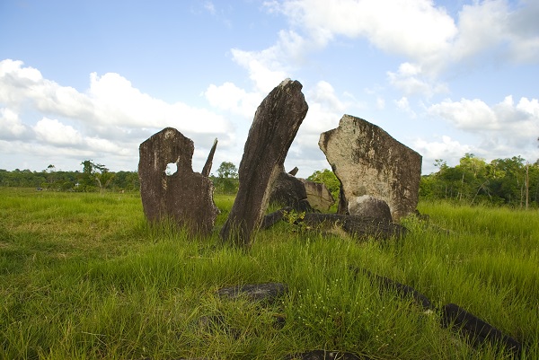
On a hilltop above the Rego Grande river in Brazil's far north, 127 granite megaliths stand in a circle that has tracked solstices and equinoxes for up to two millennia. The only known megalithic observatory of this scale in the Amazon basin, the Parque Arqueologico do Solsticio silently overturns the assumption that pre-Columbian Amazonian societies lacked monumental ambition or astronomical sophistication.
Every December 21, one stone among 127 casts no shadow. The sun passes directly overhead, and for a moment the granite and the light are in perfect agreement, as they have been for centuries before anyone alive today was born to witness it.
This is the Parque Arqueologico do Solsticio, set on a low hilltop near Calcoene in the Brazilian state of Amapa, barely two and a half degrees north of the equator. The people who raised these stones, associated with the Ariste ceramic tradition, left no written record of why they arranged granite blocks at precise azimuths and zenith angles correlating with solstitial and equinoctial events. But they left the stones themselves, and the stones still speak in the language of light and shadow.
Burial urns found among the megaliths confirm that the living and the dead shared this ground. The astronomical and the funerary converged here, suggesting a cosmology in which celestial cycles and human mortality were not separate concerns but aspects of the same story. For the builders, tracking the sun's extremes may have been less about science than about maintaining a relationship with forces they understood as alive.
The site was largely forgotten until modern archaeology arrived. Formally inaugurated as a park in December 2024, it now stands open to anyone willing to make the long drive through Amapa's interior. What they find is not spectacle but quiet precision, granite and sky collaborating across a gap of millennia.
Context and lineage
No surviving oral traditions connect directly to the site's original builders. The Ariste culture that created the megaliths appears to have declined before or during early colonial contact, and the specific beliefs and ceremonies practiced here were not transmitted to documented successor communities. The site's rediscovery has been entirely archaeological, moving from Goeldi's initial reports through Nimuendaju's regional mapping to Cabral and Saldanha's systematic excavations that established it as a site of hemispheric importance.
Ariste/Cunani culture builders
historical
The unnamed people who raised 127 granite megaliths on this hilltop and buried their dead among stones calibrated to the sun. Their exact ethnic and linguistic identity remains unknown, but their ceramic tradition links them to broader cultural networks extending to Marajo Island.
Emilio Goeldi
historical
Swiss-born naturalist and director of the Museu Paraense who first documented the Rego Grande megalithic site in the late nineteenth century during expeditions through the Rio Cunani area. His reports brought the stones to outside attention for the first time.
Curt Nimuendaju
historical
German-Brazilian ethnographer who described nine groups of megaliths in the Calcoene region in the 1920s. His systematic documentation established the broader megalithic landscape beyond the main circle.
Mariana Petry Cabral
historical
Archaeologist at IEPA and manager of NuParq who co-led systematic excavations beginning in 2005. Co-author of the foundational publication 'Paisagens megaliticas na costa norte do Amapa' (2008), her work revealed the site's full scale and significance.
Joao Darcy de Moura Saldanha
historical
Archaeologist at IEPA/NuParq who co-led excavation campaigns from 2005 and co-authored key research establishing the site within a landscape of over twenty megalithic structures, burial caves, and ancient villages.
Why this place is sacred
Several factors converge to make this hilltop something more than an archaeological curiosity. The site's latitude, approximately 2.6 degrees north of the equator, places it in one of the few zones on Earth where the sun passes directly overhead twice a year. The builders exploited this geography with evident intention, positioning megaliths at azimuths that correspond to both solstice and equinox events.
The hilltop itself commands the surrounding landscape and the Rego Grande river below. Elevation and horizon are essential to solar observation, and the builders' choice of this particular rise suggests they were reading the land as carefully as they read the sky. The river's proximity adds another dimension: in many Amazonian cosmologies, water is a conduit between worlds, and the placement of a ceremonial and mortuary site overlooking a river follows patterns found across indigenous South American traditions.
The presence of anthropomorphic funerary urns and offering vessels among the megaliths is perhaps the most telling detail. This was not merely an observatory. The dead were placed here, amid the stones that marked the sun's turning points. Whatever the builders understood about the relationship between death and celestial rhythm, they made it physical, embedding the departed within a structure calibrated to the cosmos. That convergence of the mortal and the astronomical gives the site its particular gravity.
Evidence suggests the megalithic circle served simultaneously as an astronomical observatory, a ceremonial gathering place, and a burial ground. The integration of these functions reflects a worldview in which tracking the sun, honoring the dead, and performing communal ritual were aspects of a single practice rather than separate activities. The broader landscape, which contains over twenty additional megalithic structures, burial caves, a mound, and ancient village sites, indicates the circle was the ceremonial center of a larger settled community.
The site's original culture, associated with the Ariste or Cunani ceramic tradition, appears to have declined before or during early colonial contact. For centuries, the megaliths stood without the community that raised them. Swiss naturalist Emilio Goeldi documented the Rego Grande site in the late nineteenth century, and German-Brazilian ethnographer Curt Nimuendaju mapped nine groups of megaliths in the region in the 1920s. But systematic excavation did not begin until 2005, when archaeologists Mariana Petry Cabral and Joao Darcy de Moura Saldanha from IEPA launched campaigns that revealed the full scale of the megalithic landscape. The site was designated an Archaeological Park in 2006 and formally inaugurated with visitor infrastructure in December 2024, timed to the solstice it was built to mark.
Traditions and practice
Archaeological evidence points to funerary ceremonies involving anthropomorphic ceramic urns and decorated offering vessels, likely timed to solstitial and equinoctial events. The urns, associated with the Ariste ceramic phase, show stylistic parallels to Marajo Island traditions, suggesting participation in a broader network of ritual practice across the Amazon delta region. The integration of burials with astronomically aligned megaliths indicates that mortuary rites and celestial observation were intertwined, though the specific form these ceremonies took is a matter of scholarly inference rather than documented record.
Visitors gather at the site during the December 21 solstice to observe the shadow-disappearance phenomenon, unconsciously reenacting the site's ancestral function. The park's interpretation center, inaugurated in December 2024, provides guided visits that contextualize the stones within their archaeological and astronomical framework. Beyond the solstice gathering, no organized spiritual or ceremonial practices take place at the site.
Walk the full circumference of the circle before entering it. Notice how the megaliths vary in height, angle, and spacing. These variations are not random but encoded with astronomical information, each stone positioned at a specific azimuth.
Once inside the circle, find the megalith associated with the solstice alignment and study its angle. Even outside December, the stone's inclination speaks of its purpose. Consider what it meant to a culture without written language to encode their deepest astronomical knowledge in granite, trusting that stone would outlast memory.
From the hilltop, look toward the Rego Grande river. The builders chose this elevation deliberately. Stand where they stood and notice how the horizon line frames the sky, how the landscape itself becomes an instrument of observation when you occupy the right vantage point.
If time permits, explore beyond the main circle. The surrounding landscape holds over twenty additional megalithic structures, burial caves, and ancient village sites. The circle was not isolated but central to a community that lived, died, and watched the sky from this particular stretch of earth.
Pre-Columbian Amazonian indigenous (Ariste/Cunani culture)
HistoricalThe Ariste (Cunani) culture created this megalithic complex as an integrated astronomical observatory, ceremonial center, and burial ground. Their work demonstrates advanced knowledge of solar astronomy, monumental stone architecture, and elaborate funerary practice, overturning assumptions that pre-Columbian Amazonian societies lacked the complexity for such undertakings. The site is the only known megalithic observatory of this scale in the Amazon basin.
Astronomical observation of solstices and equinoxes using precisely positioned megaliths. Funerary ceremonies involving anthropomorphic ceramic urns and decorated offering vessels. Probable communal gatherings at the stone circle timed to celestial events.
Archaeological and archaeoastronomical research
ActiveSince 2005, the site has been the focus of systematic archaeological investigation that has reshaped understanding of pre-Columbian Amazonian civilizations. Ongoing archaeoastronomical analysis continues to refine understanding of the megalithic alignments and their relationship to solar events.
Excavation campaigns, ceramic analysis, radiocarbon dating, archaeoastronomical surveying of megalithic azimuths and zenith angles, and landscape archaeology mapping the broader complex of megaliths, burial caves, and settlement sites.
Heritage conservation and cultural tourism
ActiveThe site's designation as an Archaeological Park in 2006, followed by IPHAN and state government investment and the formal inauguration of visitor infrastructure in December 2024, represents an active commitment to preserving and interpreting the site for public engagement.
Guided interpretation visits, exhibition programming at the park's new interpretation center, annual December solstice gatherings, and ongoing conservation management of the megalithic structures against tropical weathering and erosion.
Experience and perspectives
The drive itself is part of the experience. Nearly five hundred kilometers of highway through Amapa's interior, the landscape gradually emptying of urban clutter until the road becomes a corridor between forest and sky. By the time you reach Calcoene, the ordinary world feels distant. The final seven kilometers to the park are a threshold crossing of their own.
From the parking area, a short walk leads uphill to the stone circle. The megaliths come into view gradually, granite pillars standing up to four meters tall, arranged in a rough circle more than thirty meters across. The scale is not overwhelming in the way of Stonehenge or the great pyramids. Instead, the impression is of quiet deliberation, stones set with care on a hilltop where the sky is enormous and the river glints below.
Visitors who arrive near the December solstice can witness the event the builders calibrated for: one particular megalith losing its shadow entirely as the sun passes directly overhead. The effect is subtle, not dramatic, which makes it more remarkable. No theatrical staging, no grand architecture framing the moment. Just stone and sun in agreement, as they have been for up to two thousand years.
For those who come at other times, the site offers something different but no less affecting. The surrounding landscape of additional megaliths, burial caves, and ancient village sites extends the encounter beyond a single circle, suggesting a community that invested generations in this particular hilltop and its relationship with the sky.
Give yourself time. The site itself can be walked in an hour, but the contemplative quality deepens if you sit with the stones rather than simply circling them. Stand at the center of the circle and look outward in all directions. Notice how the megaliths frame the horizon. Consider that the builders stood where you stand, watching the same sun track the same arc, and arranged these stones to hold that knowledge in place.
If you visit during the dry season, the late afternoon light transforms the granite, warming the stone from grey to gold. The Rego Grande river is visible from the hilltop, and the sound of the surrounding landscape, insects, birds, wind through grass, fills what would otherwise be silence.
The Parque Arqueologico do Solsticio sits at an intersection of disciplines and interpretations. Archaeologists, archaeoastronomers, and popular commentators each bring different lenses to stones that predate all their frameworks. The site is young in terms of scholarly attention, and much remains genuinely open.
Archaeological consensus, established primarily through the work of Cabral and Saldanha from 2005 onward, interprets the site as a pre-Columbian astronomical observatory, ceremonial center, and burial ground created by an indigenous Amazonian culture associated with the Ariste/Cunani ceramic tradition between 500 and 2,000 years ago. Academic literature describes it as an equinoctial cromlech with menhirs positioned at azimuths and zenith angles correlating with solstice and equinox events. The broader landscape of over twenty megalithic structures, burial caves, mounds, and village sites indicates a complex, settled society rather than a nomadic population. The site has fundamentally shifted scholarly understanding of pre-Columbian Amazonian civilizations, providing material evidence of monumental architecture and sophisticated astronomical knowledge in a region previously assumed to have supported only small-scale societies.
The specific beliefs of the site's original builders have not survived in documented oral traditions. The culture appears to have declined before or during early colonial contact, leaving no known successor community with direct ritual continuity. However, the site's function likely reflected animistic worldviews common to Amazonian indigenous cosmologies, in which celestial events, landscape features, and stone formations possess spiritual agency. The integration of funerary practice with astronomical observation suggests a cosmology in which the cycles of the sun and the passage of the dead were understood as related phenomena.
Popular accounts frequently label the site the 'Amazon Stonehenge' or 'Brazilian Stonehenge,' drawing comparisons to the famous British monument. While this framing has raised the site's international profile, it also risks reducing it to a derivative curiosity rather than recognizing it as a distinct achievement of Amazonian civilization. Some popular narratives emphasize the site as evidence of 'lost civilizations' in the Amazon, though mainstream archaeology attributes it to known regional indigenous cultures whose sophistication was simply underestimated.
Genuine mysteries remain abundant. The exact cultural identity of the builders is uncertain; they are associated with the Ariste/Cunani ceramic tradition, but their ethnic and linguistic affiliation is unknown. The stones themselves have not been directly dated, only the pottery found among them, leaving a broad window of 500 to 2,000 years ago. The full extent and function of the twenty-plus additional megalithic structures in the surrounding landscape are still being investigated. Why the site was abandoned remains an open question. And the dual naming, Parque Arqueologico do Solsticio versus Parque Arqueologico dos Equinocios, reflects an unresolved tension: the most famous alignment is solstitial, but the academic literature describes it as an equinoctial cromlech.
Visit planning
Drive from Macapa via BR-156, which is fully paved. The site is 7 km from the town of Calcoene. A short walk from the parking area leads uphill to the stone circle. Accommodation options in Calcoene are limited; advance booking is strongly recommended, especially during the December solstice period. For visit coordination, the local contact is Walmir at +55 96 9904 0203. No mobile phone signal information was available at time of writing; check with park staff or local tourism offices for current connectivity details. For emergency access, Calcoene town (7 km from the site) is the nearest settlement with services.
Calcoene offers limited accommodation. Book in advance, particularly during the December solstice period when the site attracts its largest gatherings. Macapa, the state capital, has a fuller range of hotels but is a full day's drive away. No retreat centers or spiritually oriented accommodation are known in the area.
The site is managed as an archaeological park with standard heritage protection protocols. Preservation is the primary concern. Treat the stones and surrounding archaeological features with the care owed to structures that have endured for up to two millennia.
Practical clothing for tropical outdoor conditions. Sun protection is essential given the exposed hilltop location and equatorial latitude. Closed-toed shoes with good grip for the walk to the hilltop. Rain gear during wet season months. Bring insect repellent and water, as facilities at the site are limited.
No specific restrictions have been documented beyond standard archaeological site courtesy. Do not use flash against the stones. Do not position yourself on or against the megaliths for photographs. Be mindful of other visitors seeking a contemplative experience.
Do not touch, climb, or disturb the megaliths or archaeological features. Follow park guidelines and stay on designated paths. Entrance fee is approximately R$15 per person as of 2025, subject to change.
Plan your visit
Address
68960-000 - Calçoene, AP, 68960-000, Brazil
Phone
Hours, fees, and access can change — verify on the official source before you travel. Practical details last checked Jun 2026.
Nearby sacred places
Sacred places within a half-day’s reach. Pilgrims often visit them together: walk one, stay for the other.
Caninde, Estátua de São Francisco
Canindé, Ceará, Brazil
1515.2 km away

Parque Nacional Serra da Capivara
São Raimundo Nonato, Brazil
1566.9 km away

Juazeiro do Norte, Colina do Horto
Juazeiro do Norte, Ceará, Brazil
1693.5 km away

Bom Jesus da Lapa, Santuário do Bom Jesus da Lapa
Bom Jesus da Lapa, Bahia, Brazil
1954.3 km away
References
Sources consulted when researching this page. Independent verification by readers is welcome.
- 01Paisagens megalíticas na costa norte do Amapá - Revista de Arqueologia (Cabral & Saldanha, 2008) — Mariana Petry Cabral, João Darcy de Moura Saldanhahigh-reliability
- 02Cartography of archaeoastronomical techniques in the Calçoene equinoctial cromlech - Conciliumhigh-reliability
- 03PAC Patrimônio Histórico: Governo do Amapá garante aprovação da criação do Parque do Solstício em Calçoene - Portal Governo do Amapáhigh-reliability
- 04Parque Arqueológico do Solstício - Wikipedia
- 05Parque Arqueológico do Solstício: Brazil's Amazonian Stonehenge - LAC Geo
- 06Calcoene megalithic observatory - Amazon Stonehenge - Wondermondo
- 07Calçoene Stone Circle - The Megalithic Portal
- 08Calçoene – Amazon Stonehenge And The Mysterious Amapán Megalithic Culture - Ancient Pages
- 09Amapá inaugura o Parque Arqueológico do Solstício - Portal Valor Amazônico
- 10Como visitar o Sítio Arqueológico do Amapá - Terra
Key questions
What pilgrims usually ask
- Why is Parque Arqueológico do Solstício considered sacred?
- Explore Brazil's Amazonian megalithic observatory near Calcoene, Amapa. 127 granite stones aligned to solstices and equinoxes by a pre-Columbian culture.
- What should I wear at Parque Arqueológico do Solstício?
- Practical clothing for tropical outdoor conditions. Sun protection is essential given the exposed hilltop location and equatorial latitude. Closed-toed shoes with good grip for the walk to the hilltop. Rain gear during wet season months. Bring insect repellent and water, as facilities at the site are limited.
- Can I take photos at Parque Arqueológico do Solstício?
- No specific restrictions have been documented beyond standard archaeological site courtesy. Do not use flash against the stones. Do not position yourself on or against the megaliths for photographs. Be mindful of other visitors seeking a contemplative experience.
- How long should I spend at Parque Arqueológico do Solstício?
- Allow one to two hours at the archaeological site itself. The drive from Macapa takes a full day each way via BR-156 (460 km, fully paved), so plan a minimum two-day trip with an overnight stay in Calcoene.
- How do you visit Parque Arqueológico do Solstício?
- Drive from Macapa via BR-156, which is fully paved. The site is 7 km from the town of Calcoene. A short walk from the parking area leads uphill to the stone circle. Accommodation options in Calcoene are limited; advance booking is strongly recommended, especially during the December solstice period. For visit coordination, the local contact is Walmir at +55 96 9904 0203. No mobile phone signal information was available at time of writing; check with park staff or local tourism offices for current connectivity details. For emergency access, Calcoene town (7 km from the site) is the nearest settlement with services.
- What etiquette should visitors follow at Parque Arqueológico do Solstício?
- The site is managed as an archaeological park with standard heritage protection protocols. Preservation is the primary concern. Treat the stones and surrounding archaeological features with the care owed to structures that have endured for up to two millennia.
- Who is associated with Parque Arqueológico do Solstício?
- Ariste/Cunani culture builders (historical), Emilio Goeldi (historical), Curt Nimuendaju (historical), Mariana Petry Cabral (historical), Joao Darcy de Moura Saldanha (historical)