Mount Brandon, County Kerry, Ireland
Ireland's second-highest peak, where pre-Christian harvest rites and Brendan's Atlantic vision share a single summit
County Kerry, Kenmare Municipal District, Ireland
Plan this visit
Practical context before you go
Saints' Road from Ballybrack to summit and return: three to four hours. Faha route from the northern side: four to six hours. Full Cosan na Naomh from Ventry Strand to Ballybrack: five and a half to six hours (eighteen kilometers, without summit ascent). Full Cosan na Naomh plus summit: eight to ten hours.
Saints' Road (most direct route): drive to Ballybrack car park on the western side of the mountain. Faha route: drive to Faha near Cloghane village on the northern side. Cosan na Naomh starts at Ventry Strand beach. All routes are accessible from Dingle town, approximately twenty to thirty minutes by car. No public transport to trailheads. Free parking at Ballybrack. Guided walks available from operators in the Dingle area including Celtic Nature and Kerry Climbing. Mobile phone signal is unreliable on the ridges; carry a physical map and compass. Emergency mountain rescue services cover the area but response times to the summit may be lengthy.
Mount Brandon is both a sacred pilgrimage mountain and a popular hiking destination. Respect for the summit monuments, the living pilgrimage tradition, and the mountain environment is essential. The summit features are protected National Monuments.
At a glance
- Coordinates
- 52.2351, -10.2543
- Suggested duration
- Saints' Road from Ballybrack to summit and return: three to four hours. Faha route from the northern side: four to six hours. Full Cosan na Naomh from Ventry Strand to Ballybrack: five and a half to six hours (eighteen kilometers, without summit ascent). Full Cosan na Naomh plus summit: eight to ten hours.
- Access
- Saints' Road (most direct route): drive to Ballybrack car park on the western side of the mountain. Faha route: drive to Faha near Cloghane village on the northern side. Cosan na Naomh starts at Ventry Strand beach. All routes are accessible from Dingle town, approximately twenty to thirty minutes by car. No public transport to trailheads. Free parking at Ballybrack. Guided walks available from operators in the Dingle area including Celtic Nature and Kerry Climbing. Mobile phone signal is unreliable on the ridges; carry a physical map and compass. Emergency mountain rescue services cover the area but response times to the summit may be lengthy.
Pilgrim tips
- Full mountain hiking gear is essential: waterproof jacket and trousers, sturdy boots with ankle support, warm layers, hat and gloves. Weather changes rapidly at 952 meters altitude. The mountain is fully exposed to Atlantic weather systems. Dress for conditions significantly worse than what you see at the trailhead.
- Photography is permitted throughout. Summit monuments should not be disturbed for photographs. Mountain fog creates atmospheric conditions but also dangerous disorientation. Do not venture off-path for photographs in poor visibility.
- Mount Brandon is a serious mountain. Weather changes rapidly at 952 meters. Fog, rain, and high winds are common and can make conditions dangerous. The waymarked Cosan na Naomh trail officially ends at Ballybrack for safety reasons; the summit section is unmarked. Carry a physical Ordnance Survey map (Discovery Series 70) and compass. Mobile phone signal is unreliable on the ridges. Inform someone of your plans before climbing. Full mountain gear including waterproof clothing, sturdy boots, warm layers, hat and gloves is essential.
Overview
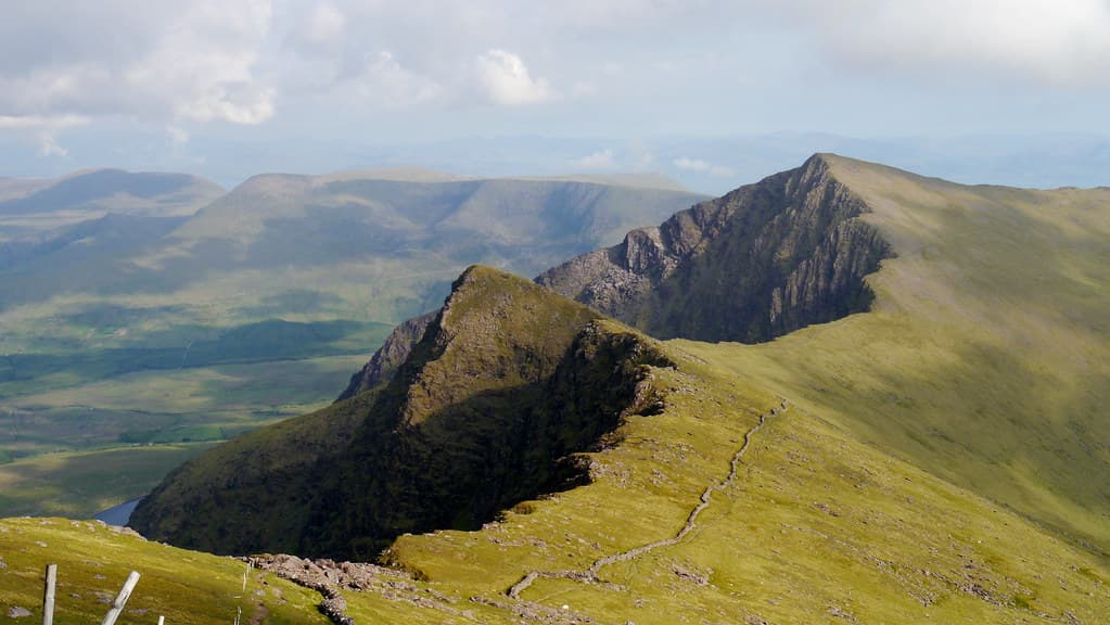
Mount Brandon rises 952 meters above the Dingle Peninsula, carrying an unbroken pilgrimage tradition from the pre-Christian Lughnasa harvest festival through the age of Saint Brendan the Navigator to the present day. The summit holds an ancient oratory, a holy well, and cross-inscribed stones where pilgrims have climbed for millennia seeking vision, healing, and encounter with something larger than themselves.
The path up Mount Brandon has been walked so long that no one knows when it began. Before Christianity, people climbed here at Lughnasa to honor Crom Dubh, the dark harvest god, and to ensure the year's grain would ripen. Saint Brendan came later, fasting for three days on the summit until an angel appeared and showed him a great land to the west across the ocean. He built an oratory on the peak, defeated the old god in the manner of saints displacing what came before, and gave the mountain the name it carries now.
Both layers remain. Each year on Crom Dubh Sunday, the last Sunday of July, pilgrims still climb the mountain. The date preserves the pre-Christian festival's timing even as the practice has been Christianized. Along the Cosan na Naomh, the Saints' Road from Ventry Strand, the path passes through Gallarus Oratory, Kilmalkedar church, and a succession of early Christian sites that constitute one of the densest concentrations of ecclesiastical ruins in Ireland. The landscape itself is a text.
At the summit, the oratory ruins sit beside Tobar Breanainn, Saint Brendan's well, where water emerges from the mountaintop. Cross-inscribed pillar stones mark the graves of the faithful. On clear days, the Blasket Islands and the open Atlantic fill the western horizon, the same prospect that may have prompted Brendan's legendary voyage.
Mount Brandon frequently sits in cloud. The path disappears into whiteness. Visibility reduces to a few feet. In these conditions, the climb becomes something other than scenic. The pilgrim walks into uncertainty, trusting the path underfoot, stripped of the visual landmarks that normally orient experience. When the summit emerges from the mist, or when it does not, the mountain has already done its work.
Context and lineage
Two origin stories converge on Mount Brandon. In the older tradition, Crom Dubh was the dark lord of the harvest, and the mountain was the site of his annual contest with the bright god Lugh at Lughnasa. The harvest depended on the outcome. In the Christian narrative, Saint Brendan climbed the mountain and fasted for three days on the summit. An angel appeared and showed him a great land to the west. This vision inspired the Navigatio Sancti Brendani, the legendary seven-year sea voyage in search of the Isle of the Blessed. One tradition recounts that when Brendan celebrated mass on the summit and realized his missal had been forgotten, the pilgrims passed it up hand-to-hand from the mountain's base, testimony to the vast numbers who gathered there.
The lineage at Mount Brandon runs from unnamed Iron Age communities who climbed at Lughnasa, through Brendan's monastic foundation at Shanakeel and the early Christian communities who built Gallarus Oratory and Kilmalkedar, to the Diocese of Kerry which maintains the mountain as a recognized pilgrimage site today. The Cosan na Naomh, restored in 1997, formally acknowledged this continuous tradition. The mountain thus embodies the full arc of Irish spiritual history, from pre-Christian harvest rites through early monasticism to living pilgrimage.
Saint Brendan the Navigator
founder
Monk and voyager (c. 484-577/583 AD) who fasted on the summit, received an angelic vision of a western land, built an oratory, and established monastic foundations at the mountain's base. His legendary sea voyage is one of Ireland's most famous narratives.
Crom Dubh
deity
Dark harvest deity associated with the mountain's pre-Christian sacred identity. His annual mythological defeat at Lughnasa ensured the grain harvest. His name survives in Crom Dubh Sunday, the last Sunday of July.
Maire MacNeill
scholar
Folklorist whose work on Lughnasa harvest festivals documented the pre-Christian origins of Irish mountain pilgrimages, including Mount Brandon's role as one of three great Lughnasa mountains.
Michael Gibbons
archaeologist
Archaeologist who discovered the extensive prehistoric farming landscape on the mountain's western slopes, including ancient field systems, stone walls, and house sites extending for several miles.
Why this place is sacred
The thinness of Mount Brandon is partly physical. At 952 meters, the summit stands high enough to hold its own weather. Cloud wraps the peak more often than not, creating conditions where the material world dissolves and the pilgrim walks in a featureless grey that demands a different kind of attention. When the cloud lifts, the views are vast: the Blasket Islands, the open Atlantic, the curve of the Dingle Peninsula below. The contrast between enclosure and revelation, between blindness and sight, is built into the mountain itself.
The spiritual layering compounds this effect. The mountain's pre-Christian name was Sliabh nDaidche, and it was one of three great mountains in Ireland, alongside Croagh Patrick and Slieve Donard, traditionally climbed at Lughnasa. The association with Crom Dubh, the dark harvest deity, connects the mountain to the most ancient stratum of Irish religious practice. Saint Brendan's overlaying of Christianity onto this site did not erase the older tradition so much as absorb it. The folk memory of Crom Dubh Sunday preserves the pagan deity's name within the Christianized festival.
The Cosan na Naomh intensifies the approach. Walking from Ventry Strand, the pilgrim passes through eighteen kilometers of early Christian heritage, each site deepening the sense of moving through a consecrated landscape toward a summit that has drawn human devotion for millennia. The concentration of oratories, churches, cross-slabs, and holy wells along the route is extraordinary for such a short distance.
At the summit, water emerging from rock, the holy well of Tobar Breanainn, carries powerful symbolic resonance. Springs at high altitude have been venerated across cultures as evidence of the sacred within the material. To drink from a well at the top of a mountain is to participate in something both simple and charged with meaning.
The mountain served as a Lughnasa pilgrimage site from at least the Iron Age, associated with rituals marking the harvest transition and the mythological contest between the bright god Lugh and the dark harvest deity Crom Dubh. Saint Brendan Christianized the site by building an oratory on the summit, fasting there, and receiving the angelic vision that inspired his legendary sea voyage.
The transition from pre-Christian to Christian use was not a clean break but a gradual absorption. Crom Dubh Sunday preserves the pre-Christian festival's timing and name within a Christian framework. The Cosan na Naomh, restored and waymarked in 1997 by the Irish Heritage Council's Pilgrim Paths Project, formalized a route that had been walked for centuries. Modern pilgrimage continues alongside hiking, with the Crom Dubh Sunday climb and the St Brendan's Day observance maintaining the living tradition.
Traditions and practice
Pre-Christian Lughnasa rituals at the mountain included the symbolic victory of Lugh over Crom Dubh, the sacrifice and eating of a bull, a mythical dance drama, the cutting of the first corn and its presentation to Lugh, and communal feasting. The Christian pilgrimage tradition involves walking the Cosan na Naomh from Ventry Strand, visiting stations and ecclesiastical sites along the route. At the summit, pilgrims traditionally circled the oratory, pillar stone, and graves nine times while reciting the Rosary, then circled Tobar Breanainn seven times and drank from the well. Pilgrims historically sought cures for ailments through the summit pilgrimage.
The annual Crom Dubh Sunday pilgrimage continues the Lughnasa tradition under its Christianized name. The St Brendan's Day observance (May 16) offers a secondary pilgrimage date. The Cosan na Naomh is walked year-round by both pilgrims and hikers. The festival weekend now includes paddle boarding, boat races, and organized community hill walks alongside traditional spiritual observances. Personal prayer and meditation at the summit oratory and holy well continue throughout the year.
Guided walks are available through operators including Celtic Nature and Kerry Climbing, offering both secular and pilgrimage-oriented options.
If you can, walk the full Cosan na Naomh from Ventry Strand rather than driving to the Ballybrack trailhead. The eighteen-kilometer approach through early Christian sites creates a progressive deepening that a direct summit assault cannot replicate. At each site along the way, pause long enough for the place to register.
At the summit, if conditions allow, sit with the oratory ruins and look west toward the Blasket Islands. Let the Atlantic horizon fill your field of vision. Then drink from Tobar Breanainn. The water is cold and clear. The act connects you physically to the mountain and symbolically to the centuries of pilgrims who have knelt at the same spring.
If you come for Crom Dubh Sunday, arrive early and be prepared for crowds. The communal dimension of the climb is part of its meaning. You are doing what others have done here for at least two thousand years.
Pre-Christian Lughnasa and Crom Dubh Veneration
HistoricalMount Brandon was one of three great mountains in Ireland traditionally climbed at Lughnasa, the Celtic harvest festival. The mountain was associated with Crom Dubh, a dark harvest deity whose annual mythological defeat ensured the year's grain harvest. The pilgrimage to the mountain is at least Iron Age in origin and possibly much older.
Lughnasa rituals at the mountain included the symbolic victory of Lugh over Crom Dubh, the sacrifice and eating of a bull, a mythical dance drama, the cutting of the first corn and its presentation to Lugh, and communal feasting. These festivals marked the critical transition from summer to harvest.
Celtic Christianity and Brendanite Tradition
ActiveSaint Brendan the Navigator Christianized the mountain by fasting on its summit, receiving an angelic vision, building an oratory, and symbolically vanquishing Crom Dubh. The Cosan na Naomh pilgrimage route, passing through Gallarus Oratory and Kilmalkedar, represents one of the most complete surviving early Christian pilgrimage landscapes in Ireland.
Walking the Cosan na Naomh from Ventry Strand, visiting stations along the route. At the summit: circling the oratory, pillar stone, and graves nine times while reciting the Rosary; circling Tobar Breanainn seven times; drinking from the well. Pilgrims have historically sought cures for ailments through the summit pilgrimage.
Roman Catholic Pilgrimage (Modern)
ActiveThe Diocese of Kerry maintains Mount Brandon as one of its recognized pilgrimage sites. The pilgrimage continues on Crom Dubh Sunday and St Brendan's Day, directly continuing the ancient tradition of climbing the mountain at the Lughnasa period. The 1997 restoration of the Cosan na Naomh formalized the continued pilgrimage tradition.
Modern pilgrims walk the Cosan na Naomh or ascend directly via the Saints' Road. The Crom Dubh Sunday pilgrimage is the main annual event. Festival activities now include paddle boarding, boat races, and community hill walks alongside traditional spiritual observances.
Experience and perspectives
The mountain teaches through the body. The climb from Ballybrack via the Saints' Road takes three to four hours in reasonable conditions, ascending through increasingly exposed terrain. The lower slopes are green and sheltered. Higher up, the vegetation thins, the wind strengthens, and the path narrows to a ridge where the drop on either side commands attention. Weather changes rapidly. Mist rolls in without warning, transforming a visible path into a test of navigation and nerve.
Those who walk the full Cosan na Naomh from Ventry Strand add five to six hours of walking through a landscape dense with early Christian heritage. Gallarus Oratory, its drystone construction still watertight after twelve centuries, stands along the route. Kilmalkedar church and its ogham stone mark another station. Each site adds a layer of historical depth that accumulates as the day progresses and the mountain draws closer.
At the summit, the ruins of Brendan's oratory sit low against the wind. Nearby, cross-inscribed stones mark the graves of those who sought burial at the mountain's peak. Tobar Breanainn, the saint's well, offers water to those who complete the climb. The traditional practice of circling the oratory and well while reciting prayers gives form to the encounter, though many contemporary visitors simply sit, look westward, and allow the altitude and effort to do what they will.
On clear days, the view from the summit extends to the Blasket Islands and beyond, out over the Atlantic toward the horizon that inspired Brendan's voyage. On clouded days, the summit exists in a world of its own: grey, windswept, intimate. Both conditions carry their own power.
Pilgrims who come on Crom Dubh Sunday share the mountain with hundreds of others, creating a communal atmosphere that echoes, however distantly, the Lughnasa gatherings of the pre-Christian era. The festival weekend now includes secular activities alongside traditional pilgrimage, reflecting the mountain's dual identity as sacred site and outdoor destination.
Mount Brandon demands respect. Check weather conditions before climbing. Carry waterproofs, warm layers, and a physical map with compass. Mobile reception is unreliable on the ridges. Tell someone your plans.
If you seek the pilgrimage dimension rather than the hike, come on Crom Dubh Sunday for the living tradition, or walk the full Cosan na Naomh on a day when you can give it unhurried attention. At the summit, drink from Tobar Breanainn. The act is simple. The resonance accumulates across centuries of pilgrims who have done the same.
Mount Brandon holds layers of meaning that span from pre-Christian harvest mythology through early Christian monasticism to living pilgrimage. Each interpretive lens reveals something genuine, and the mountain's power lies partly in how it holds all these layers together without resolving them into a single narrative.
Scholars recognize Mount Brandon as one of Ireland's most important sacred mountains, with a pilgrimage tradition spanning from the pre-Christian Iron Age to the present. Paul Tempan's research confirms the mountain was likely a pilgrimage site before both Saint Brendan and Christianity. Archaeologist Michael Gibbons has documented an extensive prehistoric farming landscape on the western slopes. The summit features are recognized as a National Monument. The Irish Heritage Council's 1997 restoration of the Cosan na Naomh formally acknowledged the route's heritage value. Maire MacNeill's work on Lughnasa established Mount Brandon's place within the broader framework of Irish harvest festival mountains.
In Catholic tradition, Mount Brandon is one of Ireland's holiest mountains, sanctified by Saint Brendan the Navigator who received his divine vision here. The mountain represents the triumph of Christianity over paganism. In older Irish tradition, the mountain was one of the three great Lughnasa pilgrimage mountains alongside Croagh Patrick and Slieve Donard. The folk memory of Crom Dubh Sunday preserves the pre-Christian harvest deity's name even within the Christianized festival. Local Kerry tradition holds that the mountain is the starting point of Brendan's legendary voyage to the Isle of the Blessed.
Contemporary pagan and neo-druidic communities celebrate Lughnasa on the mountain, viewing it as a primary site of the ancient Celtic harvest festival. The mountain is sometimes perceived as a power point within a broader sacred landscape that includes Skellig Michael and the Blasket Islands. The convergence of the pilgrimage route with the western ocean horizon is interpreted by some as connecting the site to the Celtic otherworld tradition. The Brendan voyage narrative is sometimes read as encoding ancient astronomical or navigational knowledge.
The full extent and nature of pre-Christian ritual activity on the mountain remain unknown. Whether the summit was used as a ritual site before the Iron Age is unconfirmed. The identity of the deity originally worshipped here, whether Crom Dubh, Crom Cruach, or another figure, is debated. The relationship between the prehistoric farming landscape on the western slopes and the summit ritual site has not been fully explored. Whether Brendan's legendary voyage was based on an actual Atlantic crossing remains one of Irish history's great unresolved questions.
Visit planning
Saints' Road (most direct route): drive to Ballybrack car park on the western side of the mountain. Faha route: drive to Faha near Cloghane village on the northern side. Cosan na Naomh starts at Ventry Strand beach. All routes are accessible from Dingle town, approximately twenty to thirty minutes by car. No public transport to trailheads. Free parking at Ballybrack. Guided walks available from operators in the Dingle area including Celtic Nature and Kerry Climbing. Mobile phone signal is unreliable on the ridges; carry a physical map and compass. Emergency mountain rescue services cover the area but response times to the summit may be lengthy.
Dingle town (approximately 20-30 minutes from trailheads) offers a full range of accommodation from hostels to hotels. Cloghane and Castlegregory on the northern side of the mountain provide B&B options closer to the Faha route. Ventry has accommodation near the start of the Cosan na Naomh.
Mount Brandon is both a sacred pilgrimage mountain and a popular hiking destination. Respect for the summit monuments, the living pilgrimage tradition, and the mountain environment is essential. The summit features are protected National Monuments.
Full mountain hiking gear is essential: waterproof jacket and trousers, sturdy boots with ankle support, warm layers, hat and gloves. Weather changes rapidly at 952 meters altitude. The mountain is fully exposed to Atlantic weather systems. Dress for conditions significantly worse than what you see at the trailhead.
Photography is permitted throughout. Summit monuments should not be disturbed for photographs. Mountain fog creates atmospheric conditions but also dangerous disorientation. Do not venture off-path for photographs in poor visibility.
The traditional practice is to drink from Tobar Breanainn at the summit. Some pilgrims leave small natural items or prayers at the oratory. No manufactured items should be left. Leave no trace of your visit.
Summit monuments are protected National Monuments and must not be disturbed or removed. Carry a physical Ordnance Survey map and compass as mobile signal is unreliable. Do not attempt the summit in dangerous weather conditions. The waymarked trail officially ends at Ballybrack for safety reasons. Leave no trace. Respect the pilgrimage tradition if visiting on Crom Dubh Sunday or St Brendan's Day.
Plan your visit
Address
Brandon Peak, Glanshanacuirp, Co. Kerry, Ireland
Hours, fees, and access can change — verify on the official source before you travel. Practical details last checked Jun 2026.
Nearby sacred places
Sacred places within a half-day’s reach. Pilgrims often visit them together: walk one, stay for the other.

Skellig Michael
County Kerry, Kenmare Municipal District, Ireland
55.2 km away
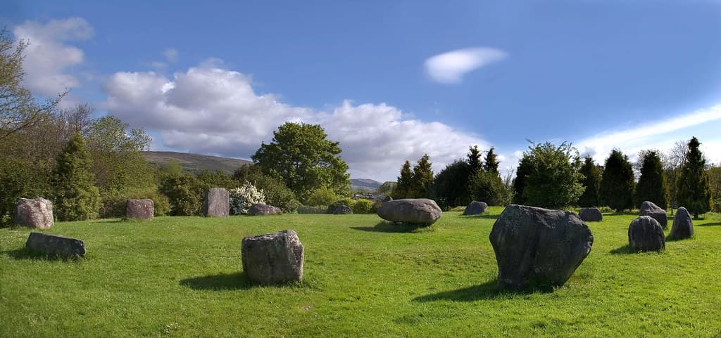
Kenmare Stone Circle, Kenmare, Ireland
Kenmare, Kenmare Municipal District, Ireland
60.4 km away
St Gobnait's well (Ballyvourney)
Ballyvourney, County Cork, Ireland
81.2 km away
Drombeg Stone Circle, Glandore, Ireland
County Cork, West Cork, Ireland
109.4 km away
Key questions
What pilgrims usually ask
- Why is Mount Brandon, County Kerry, Ireland considered sacred?
- Follow the Saints' Road to Mount Brandon's summit, where Brendan's oratory and holy well await above the Atlantic. A living Kerry pilgrimage since the Iron Age.
- What should I wear at Mount Brandon, County Kerry, Ireland?
- Full mountain hiking gear is essential: waterproof jacket and trousers, sturdy boots with ankle support, warm layers, hat and gloves. Weather changes rapidly at 952 meters altitude. The mountain is fully exposed to Atlantic weather systems. Dress for conditions significantly worse than what you see at the trailhead.
- Can I take photos at Mount Brandon, County Kerry, Ireland?
- Photography is permitted throughout. Summit monuments should not be disturbed for photographs. Mountain fog creates atmospheric conditions but also dangerous disorientation. Do not venture off-path for photographs in poor visibility.
- How long should I spend at Mount Brandon, County Kerry, Ireland?
- Saints' Road from Ballybrack to summit and return: three to four hours. Faha route from the northern side: four to six hours. Full Cosan na Naomh from Ventry Strand to Ballybrack: five and a half to six hours (eighteen kilometers, without summit ascent). Full Cosan na Naomh plus summit: eight to ten hours.
- How do you visit Mount Brandon, County Kerry, Ireland?
- Saints' Road (most direct route): drive to Ballybrack car park on the western side of the mountain. Faha route: drive to Faha near Cloghane village on the northern side. Cosan na Naomh starts at Ventry Strand beach. All routes are accessible from Dingle town, approximately twenty to thirty minutes by car. No public transport to trailheads. Free parking at Ballybrack. Guided walks available from operators in the Dingle area including Celtic Nature and Kerry Climbing. Mobile phone signal is unreliable on the ridges; carry a physical map and compass. Emergency mountain rescue services cover the area but response times to the summit may be lengthy.
- What offerings are appropriate at Mount Brandon, County Kerry, Ireland?
- The traditional practice is to drink from Tobar Breanainn at the summit. Some pilgrims leave small natural items or prayers at the oratory. No manufactured items should be left. Leave no trace of your visit.
- What etiquette should visitors follow at Mount Brandon, County Kerry, Ireland?
- Mount Brandon is both a sacred pilgrimage mountain and a popular hiking destination. Respect for the summit monuments, the living pilgrimage tradition, and the mountain environment is essential. The summit features are protected National Monuments.
- What is the history of Mount Brandon, County Kerry, Ireland?
- Two origin stories converge on Mount Brandon. In the older tradition, Crom Dubh was the dark lord of the harvest, and the mountain was the site of his annual contest with the bright god Lugh at Lughnasa. The harvest depended on the outcome. In the Christian narrative, Saint Brendan climbed the mountain and fasted for three days on the summit. An angel appeared and showed him a great land to the west. This vision inspired the Navigatio Sancti Brendani, the legendary seven-year sea voyage in search of the Isle of the Blessed. One tradition recounts that when Brendan celebrated mass on the summit and realized his missal had been forgotten, the pilgrims passed it up hand-to-hand from the mountain's base, testimony to the vast numbers who gathered there.