Meher Kapısı
A portal carved in living rock, holding the longest Urartian sacred text ever found
Turkey

Plan this visit
Practical context before you go
30–60 minutes at the site. Allow 3–4 hours for the full Urartian landscape circuit: Van Fortress, Meher Kapısı, and Toprakkale.
The site is located on the southern slopes of Zımzım Mountain in the Tuşba district of Van Province, approximately 7 km northeast of Van city centre and about 600 m west of the Toprakkale archaeological site. Access is by car (no direct public transport to the site itself); the final approach is on foot via the rock-cut path. Parking is available near the base of the slope. Mobile phone signal is generally available in the Van plain but may be intermittent on the mountain slope. For current access conditions, contact the Van İl Kültür ve Turizm Müdürlüğü (Van Provincial Culture and Tourism Directorate).
Meher Kapısı is an open archaeological site with no active religious community, but the inscription surface is irreplaceable and deserves careful treatment.
At a glance
- Coordinates
- 38.5147, 43.4228
- Type
- Urartian Rock-cut Shrine
- Suggested duration
- 30–60 minutes at the site. Allow 3–4 hours for the full Urartian landscape circuit: Van Fortress, Meher Kapısı, and Toprakkale.
- Access
- The site is located on the southern slopes of Zımzım Mountain in the Tuşba district of Van Province, approximately 7 km northeast of Van city centre and about 600 m west of the Toprakkale archaeological site. Access is by car (no direct public transport to the site itself); the final approach is on foot via the rock-cut path. Parking is available near the base of the slope. Mobile phone signal is generally available in the Van plain but may be intermittent on the mountain slope. For current access conditions, contact the Van İl Kültür ve Turizm Müdürlüğü (Van Provincial Culture and Tourism Directorate).
Pilgrim tips
- No religious dress requirements. Practical hiking attire is suitable. Sturdy footwear is advisable for the uneven rock-cut approach.
- Photography is generally permitted throughout the site. The inscription surface photographs well in oblique morning light.
- The rock face and steps can be slippery after rain. Do not touch or lean against the inscribed surface — even careful contact degrades cuneiform relief over time.
Overview
Meher Kapısı is a monumental niche hewn into the vertical face of Zımzım Mountain, near Van in eastern Turkey. Carved around 820–810 BCE by Urartian kings Išpuini and Minua, it bears a 94-line cuneiform inscription naming all 79 deities of the Urartian pantheon and specifying the animal sacrifices owed to each — the most complete statement of Urartian theology in existence.
Carved into the bare rock face of Zımzım Mountain, roughly seven kilometres northeast of the ancient citadel of Tuşpa (Van), Meher Kapısı is the most fully preserved sacred monument of the Urartian civilisation — a kingdom that held sway over eastern Anatolia, Armenia, and northwestern Iran for three centuries before it vanished from history around 600 BCE.
The niche itself is three-tiered: a large upper cavity measuring approximately four metres high and nearly three metres wide, reached by steps cut from the mountain face; and below, a broad rock terrace with a second, wider recess understood to be a sacrificial platform. But the monument's true significance is textual. The inner surface carries a 94-line cuneiform inscription — the longest religious text produced by the Urartian state — that names all seventy-nine deities of the pantheon in hierarchical order, from the supreme god Ḫaldi down through storm and solar deities to local divine powers, specifying the exact number of cattle, sheep, and other animals to be sacrificed to each during state ceremonies.
The name 'Meher' connects to the Anatolian solar deity and to the later Indo-Iranian figure of Mithra — suggesting that this cliff face was a sacred place before the Urartian kings formalised it in stone. What they created here was less a temple than a theological charter: the divine order of the cosmos inscribed permanently into the mountain, both declaration and performance space. Ancient tradition holds that Urartian kings were crowned in this place, sealing their authority before the assembled pantheon carved at their backs.
Today the inscription stands in silence above the Van plain. The religion it encodes is extinct. Yet the niche retains the quality of threshold — a gap in the rock that once marked the boundary between the human world and the ordered divine.
Context and lineage
The Urartian kingdom emerged in the 9th century BCE around Lake Van, building a mountain-fortress civilisation that competed with Assyria for dominance in the Near East. Kings Išpuini and Minua — father and son, ruling jointly for a period — were among the most important shapers of Urartian state ideology. Their decision to commission Meher Kapısı was part of a broader theological programme: elevating the war god Ḫaldi to supreme status, creating a unified pantheon that could serve as the spiritual foundation for an expanding empire.
The site name 'Meher' is linked by scholars to the Anatolian solar deity Mithra — an older sacred presence in the region that the Urartian royal programme chose to absorb and redirect rather than erase. The niche may have been a pre-existing sacred spot on Zımzım Mountain, a place already understood as a threshold between worlds, which Išpuini and Minua transformed into the formal codification of their pantheon.
The cuneiform script used at Meher Kapısı was adapted from Assyrian, but the Urartian language itself belongs to a different family — its closest surviving relative appears to be the Hurrian language of earlier Near Eastern civilisations. The inscription is thus a rare document: a complete theology written in a language with no living descendants, addressed to gods with no living worshippers.
Urartian state religion (c. 900–600 BCE) belongs to the broader family of Iron Age Anatolian and Near Eastern polytheisms. It shares structural elements with Mesopotamian religion — the use of cuneiform, the concept of divine hierarchies with cosmological functions — while preserving distinctly local elements. No direct religious lineage connects it to any surviving tradition. The Urartian civilisation was succeeded in the Van region by the Medes and later Persian Empire, whose Zoroastrian religion had no organic continuity with Urartian practice.
King Išpuini
Co-commissioner of the monument; Urartian king c. 830–810 BCE who began the elevation of Ḫaldi to supreme deity status and ruled jointly with his son Minua during the monument's creation
King Minua
Co-commissioner; Urartian king c. 810–785 BCE, one of the most celebrated Urartian rulers, known for extensive building and inscription campaigns across the Van region
Ḫaldi
Supreme deity of the Urartian pantheon, a war god whose primacy is established and proclaimed in the Meher Kapısı inscription; his elevation here marked a theological watershed in Urartian state religion
Why this place is sacred
The Urartian concept of sacred space did not require a built roof. A vertical rock face — hard, permanent, already possessing the gravitas of the mountain — could serve as the wall of a divine dwelling when properly inscribed and oriented. Meher Kapısı realises this theology in full: the niche is not merely decorated but constituted by its text. The 79 deities do not merely live behind the stone; they are addressed by name, each with a precise liturgical claim on the living.
The supreme deity Ḫaldi — war god, protector of the royal house, whose standard was carried into battle — stands at the head of the list. His primacy at Meher Kapısı was itself a relatively recent theological development: Išpuini and Minua were responsible for elevating Ḫaldi above the older pantheon, a move that paralleled and reinforced the consolidation of Urartian royal power. The inscription is thus both religious document and political act, the divine authority and the kingly authority issuing from the same carved surface.
The thin quality of this place arises from the overlap of registers: the mountain's geological permanence, the text's claim to codify the eternal divine order, the fact of royal coronation performed here, and the long view south across the Van basin toward the great salt lake that the Urartians called the Sea of Nairi. To stand at the foot of the niche is to stand at what was once the hinge between the human political world below and the divine legislative order above — even if both have now withdrawn.
A state religious monument serving as both cultic niche for the Urartian divine pantheon and the theological foundation for royal coronation ceremonies, codifying the ritual obligations of the Urartian kingdom toward its 79 named deities.
Created as an active ceremonial space around 820–810 BCE under Išpuini and Minua, Meher Kapısı remained significant throughout the Urartian period. After the kingdom's collapse (c. 600 BCE), the site fell out of ritual use entirely. The monument survived through the durability of rock-cut inscription rather than through any continuity of tradition, and it now functions as a heritage and archaeological landmark within the Urartian landscape of the Van region.
Traditions and practice
The inscription at Meher Kapısı specifies the ritual obligations of the Urartian state with unusual exactness: precise numbers of cattle, sheep, and other animals to be sacrificed to each of the 79 named deities, in a fixed hierarchical sequence. Ḫaldi received the greatest offering; the sequence then moved through Teišeba (storm god) and Šiuini (solar deity) to the remaining 76 deities. This was not informal piety but state liturgy — a mandated schedule of sacrificial debt owed by the kingdom to its divine patrons. Separately, Urartian tradition associated this site with royal coronation ceremonies, the king performing his investiture before the assembled inscription of divine authority.
No religious practices are performed here today. The site is visited as a heritage monument.
Arrive in the morning when the light falls directly on the inscription. Walk the cut stone steps slowly — their evenness after nearly three millennia is itself remarkable. At the foot of the niche, let your eyes move across the cuneiform surface without trying to read it. Notice the density: 94 lines of names and numbers. Consider what it meant to stand here as the list was recited aloud — god by god, sacrifice by sacrifice — the entire divine order called into presence.
When you reach the lower terrace, turn and face outward. The Van plain stretches south toward the lake. Whatever assembled here for a coronation ceremony would have faced this view: the king backed by the divine inscription, the gathered court facing the kingdom. The spatial logic of the site becomes clear from this position.
Bring the UBC Library transcription of the inscription if you wish to follow the text — even without reading Urartian, tracing the line-breaks gives a sense of the inscription's internal structure.
Urartian State Religion
HistoricalThe primary cultic site for the codification of Urartian state theology. The carved niche and its 94-line inscription defined the entire divine pantheon and the ritual obligations of the kingdom — the most complete statement of Urartian religion in existence.
Annual state sacrifice to 79 named deities in specified numbers; royal coronation ceremonies performed before the inscription; religious festivals led by the king in his capacity as chief priest of Ḫaldi.
Archaeological Heritage
ActiveMajor site for Iron Age religious studies and Urartian civilisation research. The inscription remains the primary source for Urartian theology and pantheon structure.
Scholarly study, epigraphic analysis, heritage tourism.
Experience and perspectives
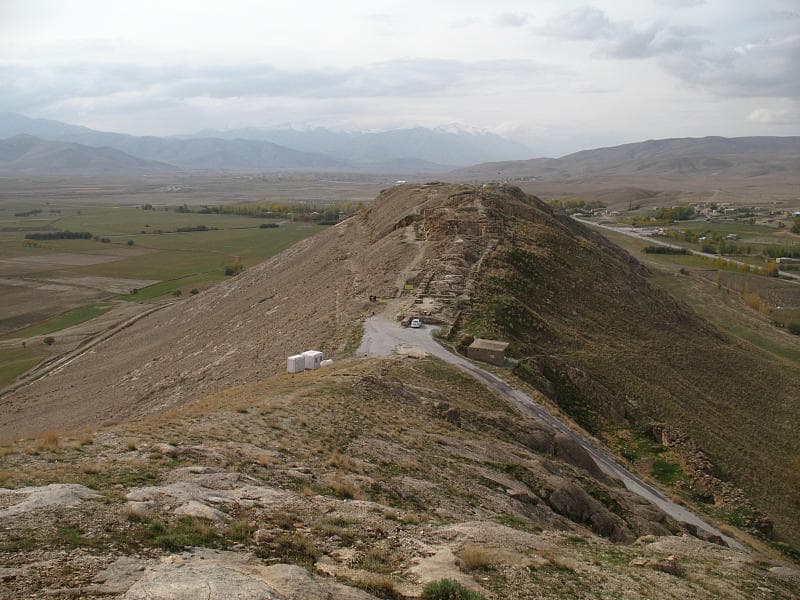
The site reveals itself gradually. From the road, Zımzım Mountain presents an unremarkable slope — stony, dry, elevated above the valley floor. The rock-cut stairs that lead up to the niche begin modestly. As you ascend, the Van plain opens behind you: the flat grey-green expanse running toward the distant salt lake, with the rock citadel of the Van Fortress visible to the southwest. The landscape is immense and exposed.
Then the niche comes into view: a rectangular cavity in the vertical cliff, the cuneiform lines still readable across its inner surface despite nearly three millennia of weathering. The scale of the inscription is not immediately obvious — the individual signs are small — but the density of the text, filling the face of the cavity from ceiling to floor, communicates its ambition. This is not a dedicatory phrase or a king's boast; it is a complete theological system, pressed into stone.
The lower terrace and sacrificial recess are broader and more open. This was where the visible, public dimension of the ceremony took place — fires, animals, priests, the king. The upper niche received the divine gaze.
The site is quiet. There is no vendor, no crowd, rarely another visitor. Wind moves across the mountain face. Below, the plain continues its indifference to whatever once happened here. The inscription remains, but its liturgical world is gone — and that gap is part of what the site offers: not the continuation of a sacred tradition, but the encounter with a fully formed one that has fallen completely silent.
Allow at least 45 minutes on site. Wear robust footwear for the rock-cut approach. The niche faces south-southwest toward the Van basin. Morning light reaches the inscription surface directly; afternoon creates shadowing that can aid reading of the cuneiform relief. The site is best visited after Van Fortress (which provides context for Urartian architecture and kingship) and before Toprakkale, which lies roughly 600 metres to the east.
Meher Kapısı is interpreted differently depending on whether the observer approaches through Urartian history, comparative Near Eastern religion, or the local cultural memory of eastern Turkey.
Scholars of Urartian civilisation regard Meher Kapısı as the definitive primary source for Urartian state religion. The joint commission by Išpuini and Minua dates to a pivotal moment in Urartian history — the theological unification of the kingdom under a single supreme deity — and the inscription's 79-god list is the most complete Urartian pantheon document known. Academic work from the Max Planck Research Library and the UBC Library's Open Collections has focused particularly on how Urartian cuneiform adapted Mesopotamian writing conventions to serve a quite different linguistic and theological programme.
No living Urartian tradition survives. The site falls within a region of cultural complexity: the Van basin is home to Kurdish and Armenian populations who trace different but overlapping ancestral connections to the Urartian landscape. Armenian historiography sometimes situates Urartian civilisation as a precursor to Armenian identity; Kurdish cultural memory engages with the region's pre-Islamic sacred geography. Neither constitutes a continuous religious tradition at Meher Kapısı itself.
The etymology of 'Meher' — linking it to the sun deity Mithra and to the later Mithraic mystery religion that spread across the Roman Empire — has attracted attention from scholars and esoteric researchers interested in continuity of solar sacred sites. The suggestion is that Zımzım Mountain was sacred before the Urartians, that their formalisation of the niche absorbed an older tradition, and that the site sits within a longer arc of solar veneration in Anatolia that eventually fed into Mithraic initiation practices.
The precise coronation ceremony that tradition associates with Meher Kapısı has not been fully reconstructed from the textual or archaeological evidence. It remains unclear how frequently the site was used for active ritual versus how much it functioned as a permanent theological statement that required no periodic maintenance. The relationship between Meher Kapısı and the nearby Toprakkale temple complex — and whether pilgrims moved between them as part of a single ceremonial landscape — is not yet resolved.
Visit planning
The site is located on the southern slopes of Zımzım Mountain in the Tuşba district of Van Province, approximately 7 km northeast of Van city centre and about 600 m west of the Toprakkale archaeological site. Access is by car (no direct public transport to the site itself); the final approach is on foot via the rock-cut path. Parking is available near the base of the slope. Mobile phone signal is generally available in the Van plain but may be intermittent on the mountain slope. For current access conditions, contact the Van İl Kültür ve Turizm Müdürlüğü (Van Provincial Culture and Tourism Directorate).
Van city centre (7 km) has a full range of hotels and guesthouses to suit all budgets. No accommodation at or near the site itself.
Meher Kapısı is an open archaeological site with no active religious community, but the inscription surface is irreplaceable and deserves careful treatment.
No religious dress requirements. Practical hiking attire is suitable. Sturdy footwear is advisable for the uneven rock-cut approach.
Photography is generally permitted throughout the site. The inscription surface photographs well in oblique morning light.
None expected or appropriate at this archaeological site.
Do not touch or lean against the inscribed niche surface. Do not climb the monument's structural features. Treat the rock-cut stairs with care, particularly after wet weather.
Nearby sacred places
Sacred places within a half-day’s reach. Pilgrims often visit them together: walk one, stay for the other.


References
Sources consulted when researching this page. Independent verification by readers is welcome.
- 01Meher Kapısı inscription (Urartian text) - UBC Library Open Collectionshigh-reliability
- 02Religion and Kingship Ideology: The God Ḫaldi and the Urartian Monarchhigh-reliability
- 03MEHER KAPI - Van İl Kültür ve Turizm Müdürlüğühigh-reliability
- 04The Spread of the Cuneiform Culture to the Urartian North (IX–VII Century BCE)high-reliability
- 05Meher Kapı - Urartian Monuments
- 06The City of Van and Ancient Tushpa | The Art of Wayfaring
Key questions
What pilgrims usually ask
- Why is Meher Kapısı considered sacred?
- A 94-line cuneiform inscription carved into Zımzım Mountain names all 79 gods of the Urartian pantheon. Stand before the longest Urartian religious text known.
- What should I wear at Meher Kapısı?
- No religious dress requirements. Practical hiking attire is suitable. Sturdy footwear is advisable for the uneven rock-cut approach.
- Can I take photos at Meher Kapısı?
- Photography is generally permitted throughout the site. The inscription surface photographs well in oblique morning light.
- How long should I spend at Meher Kapısı?
- 30–60 minutes at the site. Allow 3–4 hours for the full Urartian landscape circuit: Van Fortress, Meher Kapısı, and Toprakkale.
- How do you visit Meher Kapısı?
- The site is located on the southern slopes of Zımzım Mountain in the Tuşba district of Van Province, approximately 7 km northeast of Van city centre and about 600 m west of the Toprakkale archaeological site. Access is by car (no direct public transport to the site itself); the final approach is on foot via the rock-cut path. Parking is available near the base of the slope. Mobile phone signal is generally available in the Van plain but may be intermittent on the mountain slope. For current access conditions, contact the Van İl Kültür ve Turizm Müdürlüğü (Van Provincial Culture and Tourism Directorate).
- What offerings are appropriate at Meher Kapısı?
- None expected or appropriate at this archaeological site.
- What etiquette should visitors follow at Meher Kapısı?
- Meher Kapısı is an open archaeological site with no active religious community, but the inscription surface is irreplaceable and deserves careful treatment.
- What is the history of Meher Kapısı?
- The Urartian kingdom emerged in the 9th century BCE around Lake Van, building a mountain-fortress civilisation that competed with Assyria for dominance in the Near East. Kings Išpuini and Minua — father and son, ruling jointly for a period — were among the most important shapers of Urartian state ideology. Their decision to commission Meher Kapısı was part of a broader theological programme: elevating the war god Ḫaldi to supreme status, creating a unified pantheon that could serve as the spiritual foundation for an expanding empire. The site name 'Meher' is linked by scholars to the Anatolian solar deity Mithra — an older sacred presence in the region that the Urartian royal programme chose to absorb and redirect rather than erase. The niche may have been a pre-existing sacred spot on Zımzım Mountain, a place already understood as a threshold between worlds, which Išpuini and Minua transformed into the formal codification of their pantheon. The cuneiform script used at Meher Kapısı was adapted from Assyrian, but the Urartian language itself belongs to a different family — its closest surviving relative appears to be the Hurrian language of earlier Near Eastern civilisations. The inscription is thus a rare document: a complete theology written in a language with no living descendants, addressed to gods with no living worshippers.