Karasu Relief
The god who stands on a deer — a Luwian guardian carved 200 meters above the Karasu near the Euphrates confluence
Araban district, Gaziantep, Southeastern Anatolia Region, Turkey

Plan this visit
Practical context before you go
Half-day excursion including travel from the nearest main road, the riverbank approach, time at the site, and return.
Near Gümüşpınar village near Akbudak, Araban district, Gaziantep Province. Approximately 187 km from Gaziantep city. The relief is on a cliff face approximately 200 m above the Karasu River, roughly 3 km from the Euphrates confluence. Off-road vehicle required for the final approach; final section on foot along the riverbank. Mobile signal is absent; carry a full-day water supply and inform someone of your plans. No formal visitor infrastructure, ticketing, or emergency services at the site. For guidance on current access conditions, contact the Gaziantep Provincial Culture and Tourism Directorate.
An extremely remote open-air site with no facilities; self-sufficiency and care for the carved surface are the essential requirements.
At a glance
- Coordinates
- 37.4308, 37.9085
- Type
- Neo-Hittite Rock Relief
- Suggested duration
- Half-day excursion including travel from the nearest main road, the riverbank approach, time at the site, and return.
- Access
- Near Gümüşpınar village near Akbudak, Araban district, Gaziantep Province. Approximately 187 km from Gaziantep city. The relief is on a cliff face approximately 200 m above the Karasu River, roughly 3 km from the Euphrates confluence. Off-road vehicle required for the final approach; final section on foot along the riverbank. Mobile signal is absent; carry a full-day water supply and inform someone of your plans. No formal visitor infrastructure, ticketing, or emergency services at the site. For guidance on current access conditions, contact the Gaziantep Provincial Culture and Tourism Directorate.
Pilgrim tips
- No religious requirement. Sturdy hiking footwear and sun protection are essential for the terrain and climate of southeastern Anatolia.
- Permitted. The height of the relief makes close photography difficult; a telephoto lens or binoculars help with detail. Morning light from the east may illuminate the cliff face most clearly.
- The approach requires navigating off-road terrain in southeastern Turkey, where temperatures in summer can be extreme. Carry water for the full day, not just the walk. Do not touch or disturb the cliff face. Inform someone of your itinerary before leaving — mobile signal is absent in the valley.
Overview
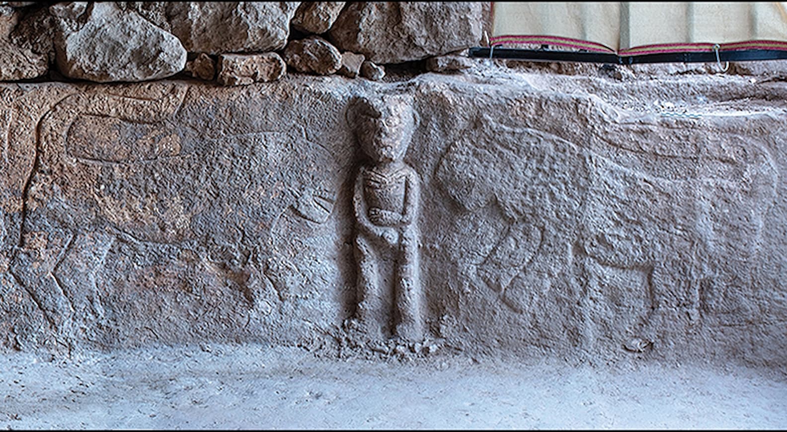
On a cliff face two hundred meters above the Karasu River near its meeting with the Euphrates, the Karasu Relief shows a deity standing on a stag: Runtiya, the Luwian-Hittite protector of the wild, boundary-keeper, guardian of territories in transition. Carved during the Iron Age when the Neo-Hittite successor states divided this landscape between them, the relief remains extraordinarily remote, almost unchanged from its original placement.
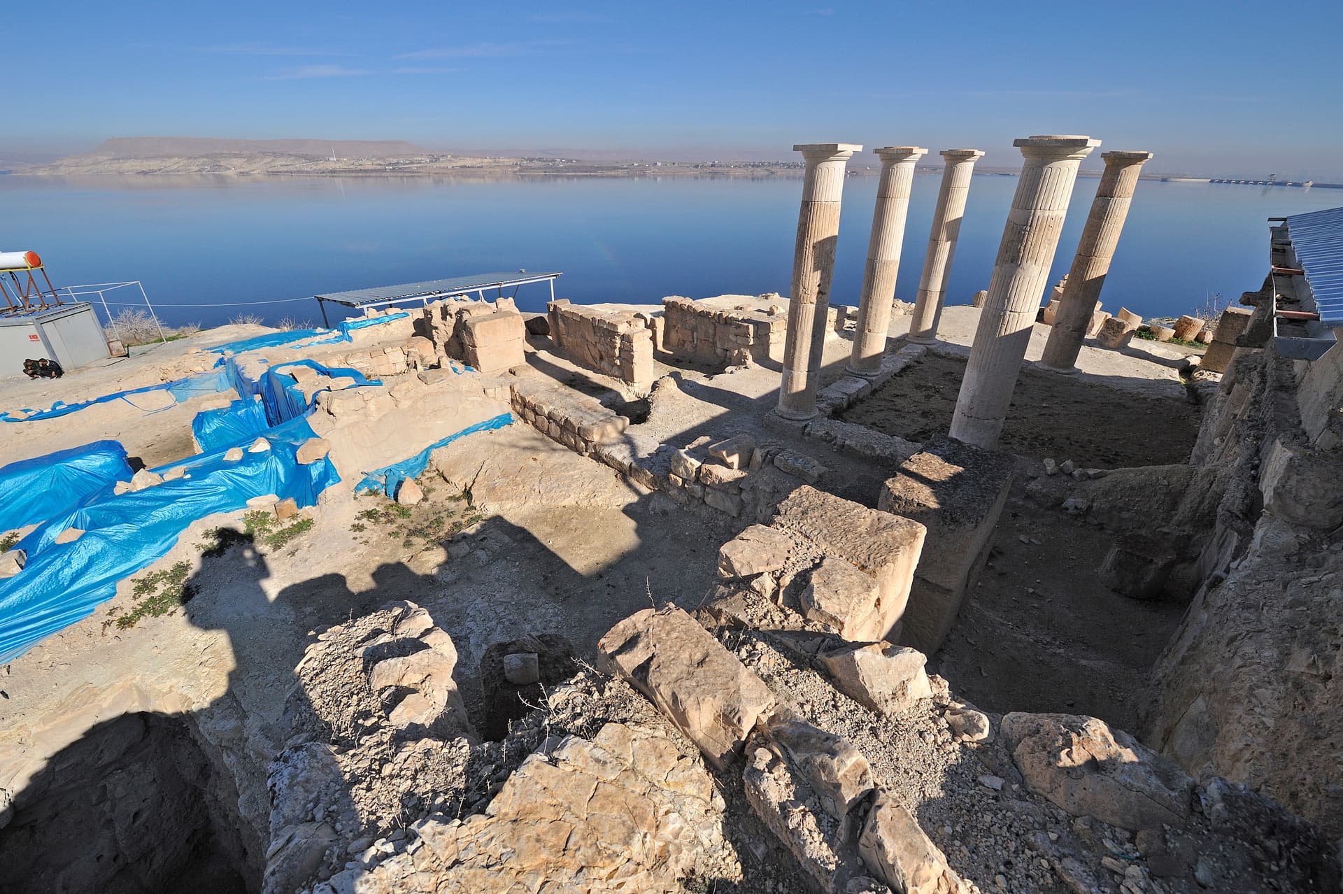
Where the Karasu River approaches its confluence with the Euphrates in what is now Araban district, Gaziantep Province, a cliff rises two hundred meters above the water. High on that cliff face, carved in stone measuring nearly two meters by two meters, stands the Karasu Relief: a deity on the back of a deer, spear raised, bow on his shoulder, a peaked cap on his beardless face. He is Runtiya — called Kurunta or Tuntija in other forms of the Luwian-Hittite religious tradition — the protective god of the wild.
The relief was carved between roughly 1050 and 850 BC, in the period when the Hittite Empire had collapsed and its successor states — smaller, Iron Age, still Luwian-speaking — divided the borderlands of southeastern Anatolia. This particular cliff marked the frontier between two such states: Kummuh to the north and Carchemish to the south. Runtiya stood at their boundary.
The motif of the god on the animal is among the oldest in the ancient Near East — attested in images stretching back to the early second millennium BC. In Hieroglyphic Luwian, Runtiya's name was itself written as the image of a deer, such that to write the deity's name was to draw the sacred animal. At this cliff above the river, that ancient identification between god and deer was carved into permanent form at a place where two rivers converge and two kingdoms met.
Context and lineage
No text accompanies the Karasu Relief. Its origin must be reconstructed from the image itself and from the political geography of the Iron Age landscape. The borderland between Kummuh and Carchemish — two of the Neo-Hittite successor states that continued Luwian cultural and religious traditions after the Hittite Empire's collapse — was precisely the kind of liminal territory that required divine guardianship. Runtiya, whose dominion was the wild spaces between settled kingdoms, was the appropriate deity for this commission.
The 'god on the animal' motif has roots in the earliest Anatolian-Mesopotamian religious art: a deity who is elevated above and carried by a sacred creature demonstrates mastery of the natural world and divine status simultaneously. By the Iron Age, this motif was ancient, carrying centuries of accumulated theological meaning.
The Karasu Relief belongs to the tradition of Neo-Hittite monumental religious art — the continuation and adaptation of Hittite imperial iconography in the Iron Age successor states of southeastern Anatolia and northern Syria. The god-on-deer motif links it to the broader Syro-Anatolian artistic tradition and, through it, to the ancient Near Eastern heritage of divine animal-rider iconography stretching back to the early Bronze Age.
Hansgerd Hellenkemper and Jörg Wagner
First academic publication with stylistic dating placing the relief in 'traditional style,' c. 1050–850 BC
Winfried Orthmann
Alternative dating to 'Late Hittite II,' c. 950–850 BC
Frank Starke
Identified the deer species as red deer (Cervus elaphus) from the carving details
Why this place is sacred
The ancient Near East understood confluences as zones of accumulated power: where rivers join, where paths converge, where territories end and begin. The meeting of the Karasu with the Euphrates was one of the great geographical thresholds of the region — the Euphrates itself ran through the heart of the ancient world's mythological geography, from Eden to Babylon to the sea.
Runtiya was not the god of cities or of particular dynasties. He was the god of the wild space between human settlements, the protector of boundaries and of hunters, the deity whose domain was the territory that no king fully controlled. Placing his image at the boundary between Kummuh and Carchemish was a theological statement about the nature of the land itself: the borderland belongs to the wild god, who holds it in his jurisdiction and protects it.
The height of the relief — two hundred meters above the river — transforms the viewer's relationship to it. You do not stand beside Runtiya; you look up at him, as you would look up at a mountain or a cliff. The elevation is part of the theology. The deer beneath him is finely carved, its antlers with two branches per side clearly rendered even at this scale: a specific red deer (Cervus elaphus), identifiable from the carving itself. Even the animal's species was a statement of natural precision, of knowing exactly which creature the god rides.
To mark the territorial and sacred boundary between the Neo-Hittite states of Kummuh and Carchemish, asserting divine protection over the wild borderland through the image of the god who rules such spaces.
Luwian religious practice at this site ceased during the early first millennium BC as the Neo-Hittite states were absorbed by Assyrian expansion. The relief's extreme inaccessibility preserved it largely from human intervention. Modern scholarship — particularly the peer-reviewed study published in Anatolian Studies — has established the iconographic identification with Runtiya and the stylistic dating, though the dating remains contested between two major scholarly positions separated by about a century.
Traditions and practice
The Luwian cult of Runtiya — the protective god of the wild — involved veneration at boundary zones, wild spaces, and sites of hunting. Votive offerings at cliff-face shrines and river confluences were common in Hittite and Neo-Hittite religious practice; liquid offerings and animal dedications would have been appropriate for a god of the hunt and the boundary. The absence of inscription suggests this relief may have functioned as a permanently visible divine presence rather than a site of frequent ritual visit — the god stationed at the boundary, requiring acknowledgment rather than elaborate ceremony.
No active religious practice is associated with the site. The extreme remoteness effectively limits visits to dedicated scholars and determined independent travelers.
The walk to the site is part of the experience. Follow the Karasu riverbank and let the valley walls establish their scale before you attempt to locate the relief on the cliff above. When you find it, resist the instinct to immediately photograph and move on. Spend time in proportion to the effort it took to arrive. The relief is high enough that you will want binoculars to see the deer's antler detail clearly; bring them. Stand at different distances and note how the composition changes — from the riverbank you see the whole, from closer you lose the whole and find the parts. Sit with the absence of inscription: an image that names nothing, attributes nothing, simply places the god where the boundary is.
Neo-Hittite / Luwian religion
HistoricalThe relief depicts Runtiya, the Luwian-Hittite god of the wild and boundaries, at a dramatic cliff overlooking the Karasu-Euphrates confluence — marking the territorial boundary between the Iron Age kingdoms of Kummuh and Carchemish with divine guardianship over the wild borderland.
Veneration of the protective god of the wild; territorial boundary marking through sacred imagery; probable votive offerings at cliff-face shrine sites along major rivers.
Archaeological heritage
ActiveImportant evidence for the persistence of Hittite-derived religious iconography in the Neo-Hittite Iron Age states, and for the 'god-on-deer' motif's deep roots in Anatolian-Near Eastern religious art. Subject of peer-reviewed study in Anatolian Studies.
Academic field surveys, iconographic publication, stylistic analysis.
Experience and perspectives
Reaching the Karasu Relief is itself a commitment. The site lies approximately 187 km from Gaziantep city, near Gümüşpınar village in Araban district, and the final approach requires an off-road vehicle and a walk along the Karasu riverbank. The river valley here is narrow, the cliffs high, the landscape dramatically removed from modern infrastructure.
The relief is on the cliff face above, and the first experience is of scale: the carved area is nearly two meters by two meters, but it occupies a cliff two hundred meters tall. You see the shape of the figure before the details — the peaked cap, the raised spear — and then, as you locate the deer beneath his feet, the composition settles into clarity. The antlers are the most precisely rendered element, their branching pattern visible from the riverbank with care.
There is no inscription on this relief. Every other Hittite or Neo-Hittite site of comparable significance carries text — dedicatory formulae, royal names, divine invocations. The Karasu Relief is silent in that specific way: it presents the image alone, without identification, without the name of whoever commissioned it. The god identifies himself by his animal and his attributes alone. In a tradition where writing the deity's name meant drawing his sacred deer, the image may have been considered sufficient.
Access via roads to Gümüşpınar village near Akbudak in Araban district, Gaziantep Province. Off-road vehicle required; final approach on foot along the Karasu riverbank. Plan for a half-day excursion including travel time. No visitor facilities. Mobile signal will be absent or minimal; prepare accordingly.
The Karasu Relief's silence — no inscription, no named dedicant — means that it speaks in imagery alone. Different interpretive frameworks illuminate different aspects of what that imagery meant and means.
The scholarly consensus identifies the figure as Runtiya (Kurunta/Tuntija), the Luwian-Hittite protective god of the wild, on the basis of the god-on-deer iconographic type attested across Hittite and Neo-Hittite art. The relief is a well-documented example of the 'traditional style' of Neo-Hittite monumental art. The dating debate — roughly a century's range between 1050 and 850 BC — reflects disagreement over how to weight stylistic versus stratigraphic criteria in dating uninscribed Iron Age monuments. The identification with Frank Starke's specific red-deer species analysis adds an unusual layer of natural precision to the iconographic reading.
No living religious tradition is specifically attached to the Karasu site. The Karasu River valley is known today primarily for its agricultural and hydroelectric resources; the ancient sacred geography of the confluence with the Euphrates has no active ritual expression in the contemporary landscape.
The deer-god figure and the Euphrates confluence have attracted interest from those studying shamanic and hunter-deity traditions across Eurasia. Runtiya-type deities — a god riding or standing on a sacred animal, associated with wildness and boundaries — appear in traditions from the steppes to the Mediterranean. The Karasu Relief can be read within this broader Eurasian pattern as well as within its specifically Luwian-Hittite context.
The dedicant is unknown and may never be identified. Whether specific ritual practices were performed at the cliff face — whether offerings were somehow raised or left at the base, whether the relief was regularly visited or simply stood as a permanent divine presence — cannot be established. The full theological significance of placing this particular deity at this particular confluence, without text, without name, belongs to a world that no longer speaks.
Visit planning
Near Gümüşpınar village near Akbudak, Araban district, Gaziantep Province. Approximately 187 km from Gaziantep city. The relief is on a cliff face approximately 200 m above the Karasu River, roughly 3 km from the Euphrates confluence. Off-road vehicle required for the final approach; final section on foot along the riverbank. Mobile signal is absent; carry a full-day water supply and inform someone of your plans. No formal visitor infrastructure, ticketing, or emergency services at the site. For guidance on current access conditions, contact the Gaziantep Provincial Culture and Tourism Directorate.
Gaziantep city (~187 km) is the appropriate base; it offers a full range of accommodation and is a destination in its own right for its culinary and cultural heritage. Araban town (~30 km from the site) has basic options.
An extremely remote open-air site with no facilities; self-sufficiency and care for the carved surface are the essential requirements.
No religious requirement. Sturdy hiking footwear and sun protection are essential for the terrain and climate of southeastern Anatolia.
Permitted. The height of the relief makes close photography difficult; a telephoto lens or binoculars help with detail. Morning light from the east may illuminate the cliff face most clearly.
None expected or appropriate.
Do not touch or disturb the carved surface. Do not attempt to climb the cliff face. Leave the site exactly as found.
Nearby sacred places
Sacred places within a half-day’s reach. Pilgrims often visit them together: walk one, stay for the other.

References
Sources consulted when researching this page. Independent verification by readers is welcome.
- 01The God on the Stag: A Late Hittite Rock-Relief on the River Karasu – Anatolian Studieshigh-reliability
- 02The God on the Stag: A Late Hittite Rock-Relief on the River Karasu – JSTORhigh-reliability
- 03Hittite Monuments – Karasuhigh-reliability
- 04Karasu relief – Wikipedia
- 05Runtiya – Wikipedia
- 06Karasu relief – Wikidata
Key questions
What pilgrims usually ask
- Why is Karasu Relief considered sacred?
- An Iron Age Luwian deity standing on a stag, carved on a cliff above the Karasu River near the Euphrates — among Turkey's most remote ancient rock reliefs.
- What should I wear at Karasu Relief?
- No religious requirement. Sturdy hiking footwear and sun protection are essential for the terrain and climate of southeastern Anatolia.
- Can I take photos at Karasu Relief?
- Permitted. The height of the relief makes close photography difficult; a telephoto lens or binoculars help with detail. Morning light from the east may illuminate the cliff face most clearly.
- How long should I spend at Karasu Relief?
- Half-day excursion including travel from the nearest main road, the riverbank approach, time at the site, and return.
- How do you visit Karasu Relief?
- Near Gümüşpınar village near Akbudak, Araban district, Gaziantep Province. Approximately 187 km from Gaziantep city. The relief is on a cliff face approximately 200 m above the Karasu River, roughly 3 km from the Euphrates confluence. Off-road vehicle required for the final approach; final section on foot along the riverbank. Mobile signal is absent; carry a full-day water supply and inform someone of your plans. No formal visitor infrastructure, ticketing, or emergency services at the site. For guidance on current access conditions, contact the Gaziantep Provincial Culture and Tourism Directorate.
- What offerings are appropriate at Karasu Relief?
- None expected or appropriate.
- What etiquette should visitors follow at Karasu Relief?
- An extremely remote open-air site with no facilities; self-sufficiency and care for the carved surface are the essential requirements.
- What is the history of Karasu Relief?
- No text accompanies the Karasu Relief. Its origin must be reconstructed from the image itself and from the political geography of the Iron Age landscape. The borderland between Kummuh and Carchemish — two of the Neo-Hittite successor states that continued Luwian cultural and religious traditions after the Hittite Empire's collapse — was precisely the kind of liminal territory that required divine guardianship. Runtiya, whose dominion was the wild spaces between settled kingdoms, was the appropriate deity for this commission. The 'god on the animal' motif has roots in the earliest Anatolian-Mesopotamian religious art: a deity who is elevated above and carried by a sacred creature demonstrates mastery of the natural world and divine status simultaneously. By the Iron Age, this motif was ancient, carrying centuries of accumulated theological meaning.