İvriz Monuments
At the spring named Salusa, a king carved himself before his god — and the water still flows
Konya, Halkapınar, c. 4 km south of town, Turkey

Plan this visit
Practical context before you go
One to two hours for the monument, spring, and valley walk.
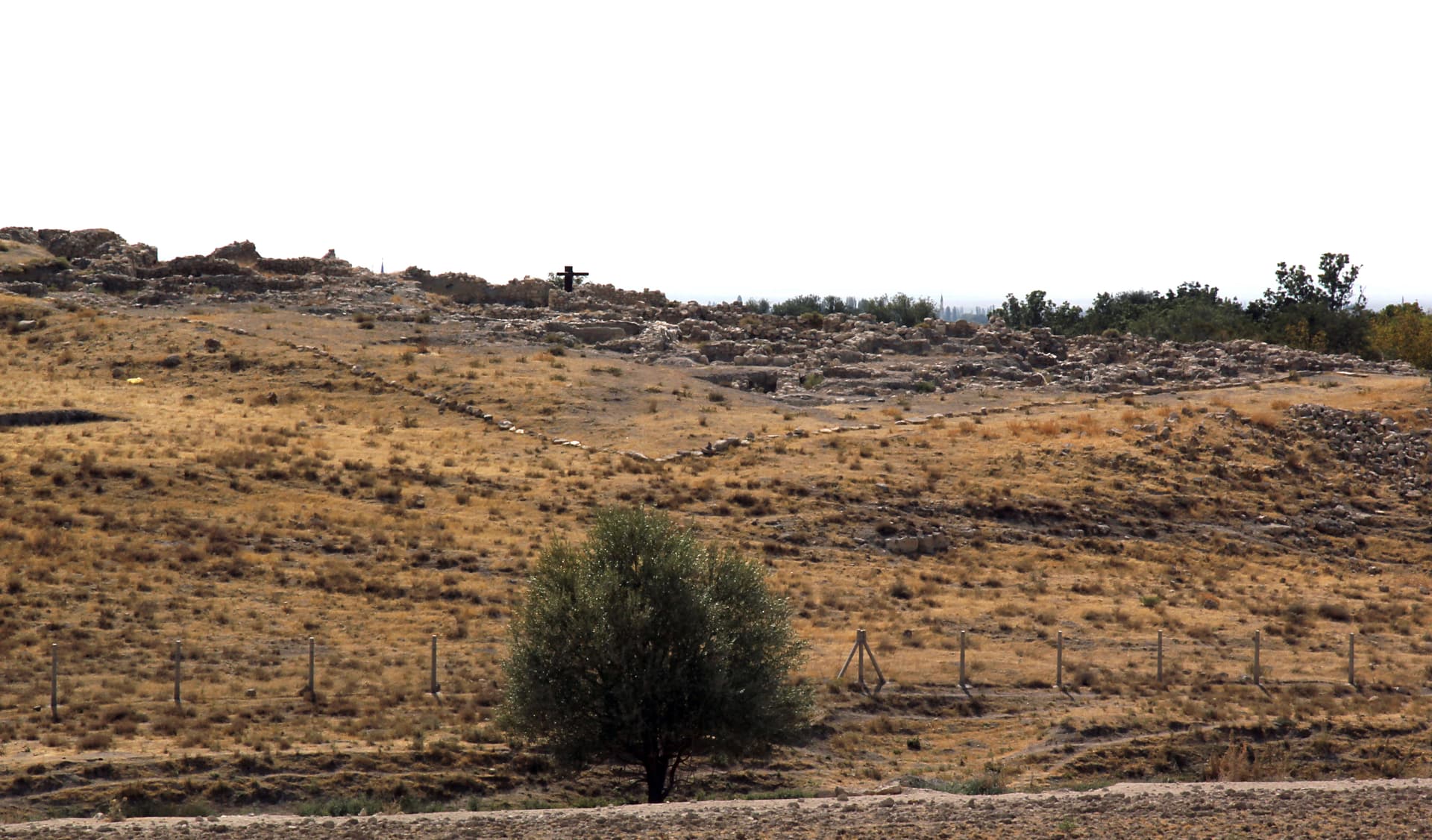
Located near Aydınkent village (formerly İvriz), approximately 2.9 km south of Halkapınar town, 17 km southeast of Ereğli, and 170 km southeast of Konya city. Best reached by private car. Halkapınar is accessible by road from Ereğli. Approximate coordinates: 37.454°N, 34.149°E.
An open heritage site at an actively flowing spring; the living water adds a dimension of responsibility that purely ruined sites do not require.
At a glance
- Coordinates
- 37.4540, 34.1490
- Type
- Rock Relief Sanctuary
- Suggested duration
- One to two hours for the monument, spring, and valley walk.
- Access
- Located near Aydınkent village (formerly İvriz), approximately 2.9 km south of Halkapınar town, 17 km southeast of Ereğli, and 170 km southeast of Konya city. Best reached by private car. Halkapınar is accessible by road from Ereğli. Approximate coordinates: 37.454°N, 34.149°E.
Pilgrim tips
- No formal requirements. Comfortable footwear for the valley path.
- Permitted. Afternoon light from the west illuminates the cliff face most favorably for the relief. The scale of the carving is best captured from a few meters back rather than close up.
- Do not touch the carved relief surface. The lower portion of the relief has experienced water damage from the spring; take care near the base. Do not divert or disturb the spring flow.
Overview
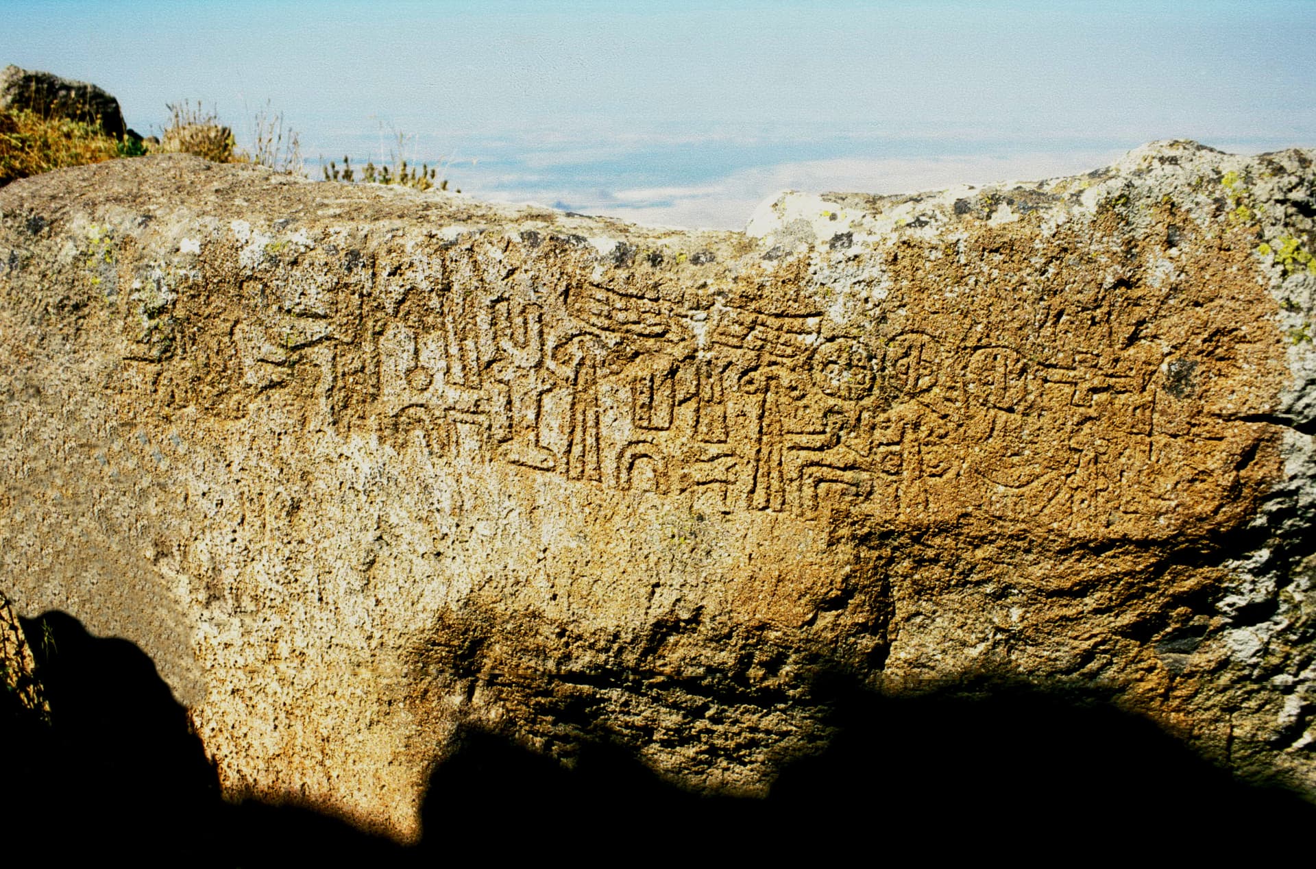
At a cliff face above a perennial spring in the Konya foothills, the Neo-Hittite king Warpalawa had himself carved in an act of worship before Tarhunzas — the storm and fertility god who held grain and grapes in his arms. The spring the god inhabited has continued to feed the Konya basin for 2,700 years. The relief above it is the largest and finest Neo-Hittite rock carving ever found.
The logic of İvriz is hydraulic and theological at once. A spring emerges from a cliff face above a valley in the Konya foothills, and its water travels downward to irrigate one of the most fertile agricultural basins in Anatolia. The Luwian-speaking people of the kingdom of Tuwana understood this water as a gift from Tarhunzas, the storm and fertility god — the deity who governed rain, rivers, grain, and vines. Their king Warpalawa, in the second half of the 8th century BCE, had a relief carved directly into the cliff above the spring source: on the left, the towering figure of Tarhunzas, holding stalks of grain and heavy grape clusters; on the right, the smaller figure of Warpalawa himself, arms raised in the gesture of worship, his inscription naming him as king and dedicant. The scale ratio between king and god is deliberate: it encodes the theology of the scene. A stele found 75 meters upstream in 1986 bears a bilingual Luwian-Phoenician inscription that names the spring itself — Salusa — confirming that the water had a sacred name, was known across the region, and was understood as a place where divine power came to the surface. The same spring still flows. The carved king and god still watch over it.
Context and lineage
Warpalawa (also known by his Aramaic name Urikki) ruled the Neo-Hittite kingdom of Tuwana in south-central Anatolia during the second half of the 8th century BCE. He was a vassal of the Assyrian king Tiglath-Pileser III and is attested in Assyrian records. At the İvriz spring — known in his time as Salusa — he commissioned a monumental rock relief as an act of royal piety: carving himself in the act of worshipping Tarhunzas at the deity's own spring. The bilingual stele found upstream in 1986, with inscriptions in both Luwian hieroglyphic and Phoenician, confirms Warpalawa's patronage and provides the ancient name of the spring for the first time. The agricultural imagery throughout — grain, grapes, the fertile basin below — indicates that the monument functioned as a royal thanksgiving for divine provision: the spring that feeds the Konya basin was, for Warpalawa, a visible demonstration of Tarhunzas's ongoing beneficence.
Late Bronze Age Hittite water cult tradition preceding the Neo-Hittite period; Neo-Hittite/Luwian royal cult of Tuwana under Warpalawa; Assyrian political context; decline of Neo-Hittite kingdoms after Assyrian conquest; spring's continued agricultural importance maintaining informal veneration; UNESCO tentative listing 2017
Why this place is sacred
Hittite and Luwian theology understood the earth as layered — an upper world of sunlight and human life, and an underworld through which divine rivers (DKASKAL.KUR) moved. Springs were the intersections: points where the sacred underground broke into the human world as water, as fertility, as life. The valley at İvriz concentrates all three layers in a single view: the cliff face rising from the valley floor, the spring emerging from its base, the water moving downhill toward agricultural abundance. Warpalawa's decision to carve his monument at this convergence was not architecturally convenient — cutting into a live cliff above a running spring presents technical challenges — but it was theologically inevitable. The spring source was where the god was; the king had to go there to worship. The relief's iconography reinforces this reading: Tarhunzas holds not weapons or thunder but grain and grapes — the biological outputs of this specific spring's fertility. He is not the storm god in an abstract cosmological sense but the lord of this water and what it produces in the basin below. The newly discovered ancient name of the spring, Salusa, adds intimacy to the site's sacred logic: this was not 'a spring' but a named presence, known and venerated across the political geography of the region.
Open-air spring sanctuary dedicated to Tarhunzas (storm and fertility god); royal dedicatory monument establishing the spring as a site of formal divine-royal covenant; the spring water itself was understood as divine presence
Active Neo-Hittite spring cult from approximately 8th century BCE; royal cult of Tuwana under Warpalawa; the spring's continued agricultural importance likely sustained local veneration after the formal political cult ended; the site entered modern heritage awareness through 19th-century European travelers; UNESCO tentative listing 2017; currently an open site with ongoing water flow
Traditions and practice
The stele inscription indicates that the İvriz sanctuary was maintained as an ongoing royal cult center, not merely the site of a single dedicatory act. Royal visits likely involved libations poured at the spring, recitation of Luwian ritual texts acknowledging the god's provision, animal sacrifice, and possibly agricultural harvest offerings. The bilingual stele — written in both Luwian and Phoenician — suggests the sanctuary was known and visited by people from beyond the immediate Tuwana kingdom, possibly as a regional pilgrimage destination.
No formal religious practices. Heritage tourism and informal visits by those interested in Hittite and Neo-Hittite history. The spring water continues to flow and is locally valued for agriculture and domestic use.
Stand before the relief and read the composition as its makers intended: the king on the right facing left toward the god, arms raised in the universal posture of petition and thanksgiving — the gesture that bodies make in every culture when they address the divine. Then look at what the god holds: not power objects but food. Grain stalks and grape clusters, the specific outputs of the spring water's path through the valley below. The theological statement is agricultural and direct: this water is a gift, and this monument is gratitude made permanent. After the main relief, walk upstream along the valley to the findspot of the bilingual stele. The valley narrows here; the sound of the water changes. In the 8th century BCE, this entire stretch of cliff and valley was a functioning sacred landscape. Give the walk enough time to feel its extent.
Neo-Hittite Storm God (Tarhunzas) Cult
HistoricalThe İvriz sanctuary is the most extensively documented Neo-Hittite spring cult site, with both a major rock relief and a bilingual dedicatory stele confirming its status as a formally maintained royal cult center. The spring source was understood as the deity's dwelling, making the monument an act of going to the god's home rather than installing the god in a man-made structure.
Royal dedications; libations at the spring; agricultural thanksgiving offerings; recitation of Luwian ritual texts; possibly periodic royal visits tied to the agricultural calendar
Archaeological and Heritage Scholarship
Activeİvriz is central to scholarship on Neo-Hittite art, Luwian epigraphy, and the political history of post-Bronze-Age Anatolia. The bilingual stele (Luwian-Phoenician) adds to the small corpus of bilingual Luwian texts. UNESCO tentative listing reflects international recognition of the site's outstanding value.
Archaeological study; epigraphic analysis; UNESCO heritage documentation; conservation of the relief surface
Experience and perspectives
The approach to İvriz from Halkapınar descends into a valley where the Taurus foothills compact into a narrow ravine. The cliff face becomes visible before the road reaches it, and the scale of the carving is larger than photographs suggest. At over four meters tall, the relief fills the cliff section above the spring source from ground level to well above standing height; the proportions of the carved figures are fully monumental. The spring water flows at the base of the cliff beneath the carved scene — in wet seasons, it emerges directly under the carved feet of Tarhunzas, which creates an unsettling intimacy between the image of the god and the water attributed to him. Walk the path below the relief slowly, moving from right to left: begin with the smaller worshipping figure of Warpalawa, whose raised-hand gesture and inscription establish the context, then move to the larger figure of Tarhunzas. The grain stalks and grape clusters in the god's arms are highly detailed even after 2,700 years of weathering — the craftsmen who carved them were clearly working from direct observation of harvest-season crops. Upstream, approximately 75 meters along the valley, is the findspot of the bilingual stele (the stele itself is now in a museum); the valley walk provides a sense of the broader sacred landscape. From the valley above the spring, the Konya basin opens outward below — the same plain that the İvriz Suyu has irrigated for millennia, the agricultural abundance that made Warpalawa's monument a statement of gratitude rather than petition.
Park at the site entrance and follow the path along the base of the cliff to the relief. After viewing the main relief, continue upstream for the broader valley context. Afternoon light illuminates the carved surface most favorably. Allow one to two hours.
İvriz is read primarily through the lens of Neo-Hittite art history and water cult theology; the recent bilingual stele discovery has added an important new textual dimension.
The İvriz relief is accepted as the finest and largest surviving Neo-Hittite rock relief, created by Warpalawa of Tuwana in the late 8th century BCE at a sacred spring source. It depicts the king worshipping the fertility and storm god Tarhunzas in a scene that links royal legitimacy to divine agricultural provision. The bilingual stele found upstream (1986) with Luwian-Phoenician inscription confirms Warpalawa's patronage and has now (through recent identification) revealed the ancient name of the spring as Salusa. UNESCO tentative listing (2017) reflects its outstanding heritage value. Warpalawa's attestation in Assyrian records as king Urikki provides external historical confirmation of his existence and political context.
No living indigenous tradition. The site is maintained by Turkish heritage authorities. The broader Anatolian tradition of holy spring (ayazma) veneration in Byzantine Christianity and informal water-source reverence in Turkish folk practice represents a cultural continuity — not direct lineage — with the deeper pattern of spring sacredness at this location.
The İvriz spring sanctuary is occasionally discussed as part of the long arc of water-source veneration in Anatolia, connecting Bronze Age Hittite DKASKAL.KUR theology through Neo-Hittite practice to Byzantine ayazma traditions and the general human inclination to locate the divine at the point where water emerges from the earth. This line of interpretation, while not scholarly in a narrow sense, captures something true about the site's depth.
The precise ritual calendar and ceremonies are not documented in surviving sources. Whether the sanctuary had a permanent priesthood or only periodic royal visits is unknown. The full extent of the broader sacred landscape — further reliefs, inscriptions, or structural remains upstream — has not been completely surveyed.
Visit planning
Located near Aydınkent village (formerly İvriz), approximately 2.9 km south of Halkapınar town, 17 km southeast of Ereğli, and 170 km southeast of Konya city. Best reached by private car. Halkapınar is accessible by road from Ereğli. Approximate coordinates: 37.454°N, 34.149°E.
Ereğli (approximately 17 km north) has modest accommodation suitable for an overnight stay. Konya city (170 km northwest) provides the full range of accommodation. The site is often visited as part of a longer Konya region itinerary.
An open heritage site at an actively flowing spring; the living water adds a dimension of responsibility that purely ruined sites do not require.
No formal requirements. Comfortable footwear for the valley path.
Permitted. Afternoon light from the west illuminates the cliff face most favorably for the relief. The scale of the carving is best captured from a few meters back rather than close up.
None traditionally expected. Do not interfere with the spring flow.
Do not touch the carved relief. Do not disturb the spring mechanism or pool. Stay on the path below the cliff face.
Nearby sacred places
Sacred places within a half-day’s reach. Pilgrims often visit them together: walk one, stay for the other.

Gökbez Relief
Bor district, Niğde, Central Anatolia Region, Turkey
55.8 km away
Köşk Höyük
Niğde, Central Anatolia / Bor plain, Turkey
59.8 km away
Karadağ Monuments
Karadağ massif, Karaman, Central Anatolia Region, Turkey
97.2 km away

Kızıldağ Monuments
South of Adakale / Çumra area, Konya, Central Anatolia Region, Turkey
97.5 km away
References
Sources consulted when researching this page. Independent verification by readers is welcome.
- 01Ivriz Cultural Landscape — UNESCO Tentative List — UNESCO World Heritage Centrehigh-reliability
- 02Hittite Monuments — İvriz — Hittite Monuments Projecthigh-reliability
- 032,700-Year-Old Luwian Stele Reveals Ancient Name of İvriz Spring and New Details on King Warpalawa — Arkeonewshigh-reliability
- 04Luwian-Hittite Inscription Reveals the Ancient Name of the İvriz Spring for the First Time — Anatolian Archaeologyhigh-reliability
- 05Ivriz Monument — Cultural Inventory of Turkey — Kültür Envanterihigh-reliability
- 06İvriz monuments — Wikipedia — Wikipedia contributors
- 07İvriz relief — Wikipedia — Wikipedia contributors
- 08Hittite monument to agriculture blesses Konya basin — Daily Sabah — Daily Sabah
Key questions
What pilgrims usually ask
- Why is İvriz Monuments considered sacred?
- Stand before the largest Neo-Hittite rock relief at the İvriz spring: King Warpalawa carved in worship before the storm god Tarhunzas — and the spring still flo
- What should I wear at İvriz Monuments?
- No formal requirements. Comfortable footwear for the valley path.
- Can I take photos at İvriz Monuments?
- Permitted. Afternoon light from the west illuminates the cliff face most favorably for the relief. The scale of the carving is best captured from a few meters back rather than close up.
- How long should I spend at İvriz Monuments?
- One to two hours for the monument, spring, and valley walk.
- How do you visit İvriz Monuments?
- Located near Aydınkent village (formerly İvriz), approximately 2.9 km south of Halkapınar town, 17 km southeast of Ereğli, and 170 km southeast of Konya city. Best reached by private car. Halkapınar is accessible by road from Ereğli. Approximate coordinates: 37.454°N, 34.149°E.
- What offerings are appropriate at İvriz Monuments?
- None traditionally expected. Do not interfere with the spring flow.
- What etiquette should visitors follow at İvriz Monuments?
- An open heritage site at an actively flowing spring; the living water adds a dimension of responsibility that purely ruined sites do not require.
- What is the history of İvriz Monuments?
- Warpalawa (also known by his Aramaic name Urikki) ruled the Neo-Hittite kingdom of Tuwana in south-central Anatolia during the second half of the 8th century BCE. He was a vassal of the Assyrian king Tiglath-Pileser III and is attested in Assyrian records. At the İvriz spring — known in his time as Salusa — he commissioned a monumental rock relief as an act of royal piety: carving himself in the act of worshipping Tarhunzas at the deity's own spring. The bilingual stele found upstream in 1986, with inscriptions in both Luwian hieroglyphic and Phoenician, confirms Warpalawa's patronage and provides the ancient name of the spring for the first time. The agricultural imagery throughout — grain, grapes, the fertile basin below — indicates that the monument functioned as a royal thanksgiving for divine provision: the spring that feeds the Konya basin was, for Warpalawa, a visible demonstration of Tarhunzas's ongoing beneficence.