Haukkavuori Rock Painting
A handprint and an inverted figure on a canoe route through Stone Age Sarkavesi
Mäntyharju, Ruokolahti / Rautjärvi area – South Karelia, Finland
Plan this visit
Practical context before you go
The painting stop itself takes 15–30 minutes; the surrounding Mäntyharju–Repovesi canoe route can extend to several hours or a full day depending on the itinerary chosen.
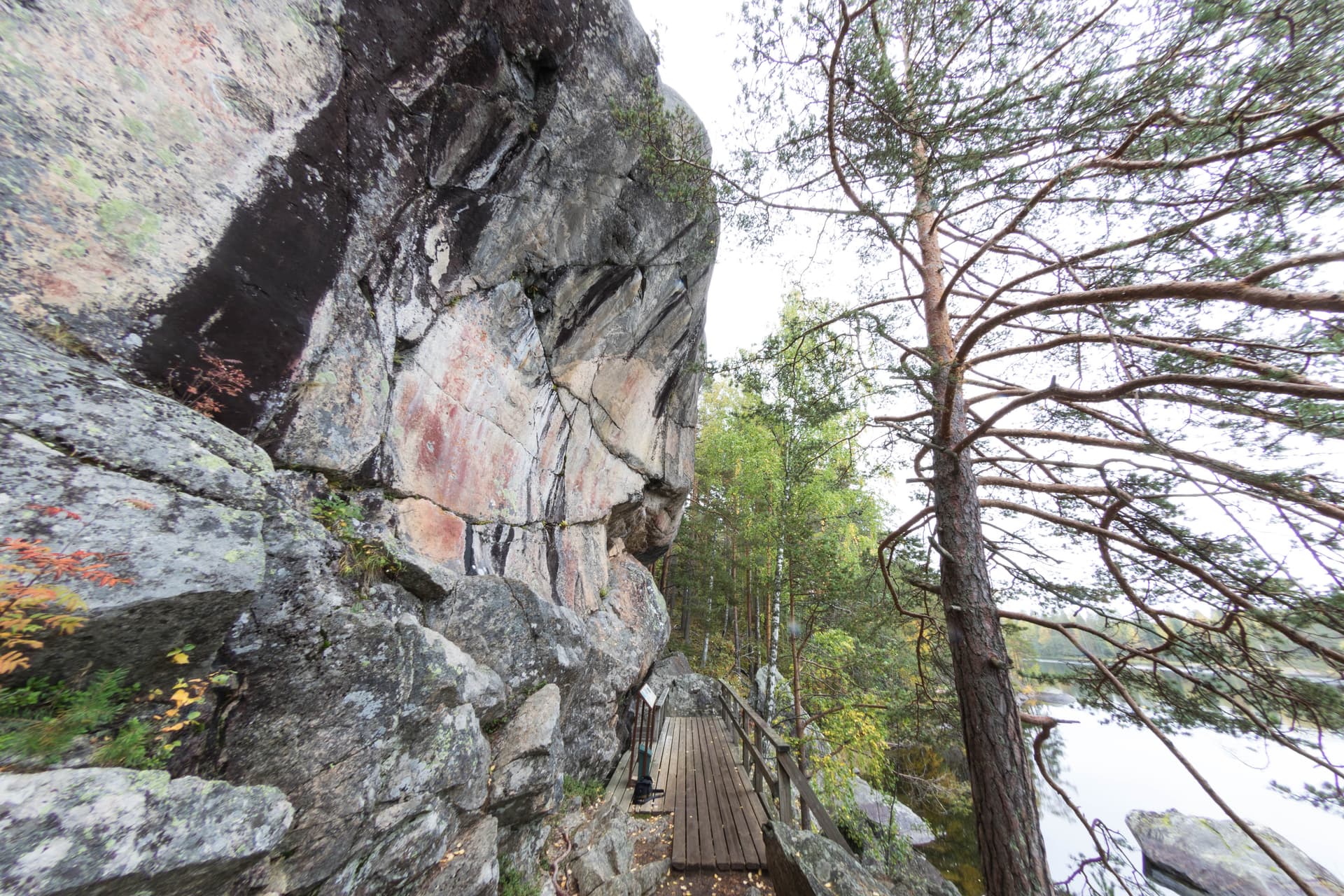
Reachable only by canoe or small boat along the Mäntyharju–Repovesi paddling route; the three image fields sit 1 to 1.5 meters above water level across a 4- to 5-meter span of rock. No mobile phone signal information was available at time of writing; parts of the surrounding Repovesi/Sarkavesi lake-and-forest landscape are remote, so paddlers should plan accordingly and inform someone of their route. For current route conditions and access guidance, contact Mäntyharju municipality tourism office at +358 40 640 2603 or matkailu@mantyharju.fi.
A protected ancient monument reached by canoe; etiquette here is primarily about safe, non-invasive water access and leaving the fragile pigment untouched.
At a glance
- Coordinates
- 61.3336, 26.7736
- Type
- Rock Art Site
- Suggested duration
- The painting stop itself takes 15–30 minutes; the surrounding Mäntyharju–Repovesi canoe route can extend to several hours or a full day depending on the itinerary chosen.
- Access
- Reachable only by canoe or small boat along the Mäntyharju–Repovesi paddling route; the three image fields sit 1 to 1.5 meters above water level across a 4- to 5-meter span of rock. No mobile phone signal information was available at time of writing; parts of the surrounding Repovesi/Sarkavesi lake-and-forest landscape are remote, so paddlers should plan accordingly and inform someone of their route. For current route conditions and access guidance, contact Mäntyharju municipality tourism office at +358 40 640 2603 or matkailu@mantyharju.fi.
Pilgrim tips
- Practical paddling attire and a personal flotation device, given that access is exclusively by canoe or small boat.
- Photography is welcomed and is the primary way most visitors document the site, given the difficulty of any other form of engagement.
- Do not touch or trace the pigment. Avoid approaching the rock wall during winter ice conditions, when currents near the site have been flagged as hazardous by the municipality. Wear a personal flotation device, as access is water-only.
Overview
Three clusters of red ochre painting line a steep rock wall on Lake Sarkavesi, reachable only by canoe. Among a moose, boats, and faded marks, two images stand apart: a clear, individual handprint, and a human figure painted upside down, head toward the water, a line of color trailing from its neck.
Haukkavuori is a paddler's site before it is anything else — there is no shore path, no parking area, no way to arrive except by water, which is very likely also how its Stone Age painters intended it to be found. Along a 4- to 5-meter stretch of steep rock wall on Sarkavesi lake in Mäntyharju, three distinct clusters of red ochre imagery survive at slightly different heights, a range that Finnish shore-chronology dating stretches across an unusually long span — from roughly 3500 BCE into the early centuries CE. The best-preserved cluster, Image Field III, holds the site's two most memorable marks: a clearly outlined handprint, pressed or painted directly onto the rock, and beside it a human figure rendered upside down — head lowered toward the water, knees slightly bent, arms raised near where the head would normally be, a vertical line of pigment descending from the neck. A painted moose, its back concave and ears or antlers ambiguous, and several boats dense with crew-lines fill the other fields. The paintings were first formally verified in 1975 by the archaeologist Timo Miettinen after a tip about a handprint on the rock — a tip that turned out to be only the most legible part of a far more layered composition.
Context and lineage
Sarkavesi lay along a water corridor that Stone Age and later hunter-fisher-gatherer communities used heavily when the region's lake levels stood higher than today. The three image fields at Haukkavuori occupy different heights on the same rock wall, a pattern Finnish archaeologists read as evidence that the location was returned to across a long period rather than painted in a single episode — possibly by successive generations of the same community, possibly by different groups drawn to the same prominent, southwest-facing rock over centuries.
Stone Age hunter-fisher-gatherer culture of the Sarkavesi corridor, with use potentially extending into the early Iron Age → undocumented until 1975 verification → national ancient monument protection → incorporation into contemporary canoe-tourism infrastructure
Why this place is sacred
What makes Haukkavuori distinctive within the Finnish rock-painting corpus is less any single image than the range of time it seems to compress. The three image fields sit at different heights corresponding to different eras of Sarkavesi's water level, meaning the wall was returned to — or at least added to — across a span that may cover two thousand years or more of hunting-culture presence in this lake corridor. Within that span, the inverted human figure in Image Field III carries the clearest interpretive weight. Head-down human postures appear elsewhere in circumpolar rock art and are generally read as images of falling, dying, or passing into an inverted or underworld state — the kind of imagery associated with shamanic cosmology, in which the practitioner's spirit crosses into a realm where ordinary orientation no longer applies. Beside this figure of transformation sits the handprint: not a symbol requiring interpretation but the unmediated trace of an actual hand, pressed directly to the same rock. The pairing of the most abstract image at the site with its most literal one is, whether intentional or accidental, one of the more affecting juxtapositions in Finnish prehistoric art.
Likely tied to hunting-culture ritual along a lake corridor that served as a major transit route when water levels stood higher — invocation, marking of passage, or a shamanic record of transformation.
Painted across an extended span from roughly 3500 BCE to as late as 500 CE, reflecting repeated use or return to the site by Stone Age and possibly early Iron Age hunter-fisher-gatherer communities; formally verified by archaeologist Timo Miettinen in 1975; later studied by Pekka Kivikäs (2005) and Antti Lahelma (2008); now a protected ancient monument and a marked stop on the modern Mäntyharju–Repovesi canoe route.
Traditions and practice
The surviving evidence is entirely visual — no record of accompanying ceremony, song, or ritual gesture survives alongside the imagery described above. The interpretive weight rests on the images' posture and the site's long span of apparent use, not on any written or oral account.
None; the site has no living ritual use and functions today purely as a protected monument and canoe-route waypoint.
Paddle the final approach slowly rather than gliding past at speed, and let the handprint be your anchor point before searching out the inverted figure beside it — the two images reward being read together rather than separately. Rest your paddle for a moment once you have both in view, and notice how the boats in the neighboring field echo the vessel you are sitting in. If time allows, extend the visit into the wider Repovesi landscape the canoe route passes through, letting the painting sit within the same water corridor its makers used.
Stone Age Sarkavesi Rock Painting Tradition
HistoricalA long-used rock wall bearing three distinct image clusters — handprint, moose, boats, and an inverted human figure — spanning an unusually wide dating range from roughly 3500 BCE to 500 CE.
Application of red ochre pigment to a steep southwest-facing lakeside rock wall at heights corresponding to different water-level eras.
Archaeological Heritage & Canoe-Route Interpretation
ActiveThe site is preserved as a protected ancient monument and actively promoted as a heritage waypoint on the modern Mäntyharju–Repovesi canoe route.
Site inventory and photographic documentation by the Finnish Heritage Agency; municipal tourism promotion and access guidance; ongoing scholarly study.
Experience and perspectives
There is no substitute for the approach by water. Paddling the Mäntyharju–Repovesi route, the rock wall at Haukkavuori rises steeply from the lake with no obvious sign of what it holds until you are close enough to distinguish pigment from natural staining. Slow down here rather than passing through. The handprint in Image Field III is the easiest image to locate first — its outline is unusually crisp for a mark this old — and once your eye has calibrated to the rock's texture, the inverted human figure beside it becomes legible: the lowered head, the raised arms, the thin trailing line of color. Take time with the moose in the adjacent field too; its concave back and ambiguous ear-or-antler shapes reward slow looking rather than a quick glance. The boats in Image Field II, dense with parallel crew-lines, suggest travel and passage in a way that resonates with your own canoe beneath you — a rare case where the visitor's mode of arrival mirrors the imagery's own subject matter. Because access is entirely water-dependent, plan for the paddling itself to be part of the experience rather than an obstacle to it.
Time your visit to the canoe route's daylight window; approach the rock wall slowly and scan low across the water rather than expecting the images to announce themselves from a distance.
Haukkavuori's long dating range and its juxtaposition of a literal handprint with an image of inversion give it a distinctive place in Finnish rock-art scholarship, even as the specific ritual meaning of its images remains debated.
Finnish rock-art researchers, drawing on Timo Miettinen's 1975 verification and later analysis by Pekka Kivikäs (2005) and Antti Lahelma (2008), treat the site's three-height composition as evidence of sustained or repeated use across a long span of hunting-culture presence on Sarkavesi, and read the inverted human figure within a broader shamanic-cosmology framework common to circumpolar rock art.
No living community traces direct cultural descent from the site's creators; it belongs to shared Finnish national prehistoric heritage rather than an actively practiced tradition.
Some general travel and outdoor-recreation writing describes the inverted figure in loosely mystical terms without engaging the specific interpretive literature; this framing is noted but treated cautiously here.
Whether the three image fields represent one community returning across generations or successive unrelated groups is unresolved, as is the precise significance of the inverted posture and its trailing line of color.
Visit planning
Reachable only by canoe or small boat along the Mäntyharju–Repovesi paddling route; the three image fields sit 1 to 1.5 meters above water level across a 4- to 5-meter span of rock. No mobile phone signal information was available at time of writing; parts of the surrounding Repovesi/Sarkavesi lake-and-forest landscape are remote, so paddlers should plan accordingly and inform someone of their route. For current route conditions and access guidance, contact Mäntyharju municipality tourism office at +358 40 640 2603 or matkailu@mantyharju.fi.
Mäntyharju town offers the nearest lodging and canoe-rental services; the Repovesi National Park area also has camping and cabin accommodation oriented to paddlers and hikers.
A protected ancient monument reached by canoe; etiquette here is primarily about safe, non-invasive water access and leaving the fragile pigment untouched.
Practical paddling attire and a personal flotation device, given that access is exclusively by canoe or small boat.
Photography is welcomed and is the primary way most visitors document the site, given the difficulty of any other form of engagement.
None are appropriate; leaving objects or markings at the site risks violating its protected status.
Do not touch or trace the painted surfaces. Avoid winter ice approach due to documented current hazards near the rock wall.
Nearby sacred places
Sacred places within a half-day’s reach. Pilgrims often visit them together: walk one, stay for the other.
Kapasaari Rock Painting
Kouvola, Mäntyharju – South Savo, Finland
12.0 km away
Uittamonsalmi Rock Painting
Mikkeli, Ristiina / Mikkeli area – South Savo, Finland
34.8 km away
Astuvansalmi Rock Paintings
Mikkeli (Ristiina), Mikkeli / Ristiina – South Savo, Finland
42.4 km away
Syrjäsalmi Rock Painting
Puumala, Puumala / Saimaa area – South Savo, Finland
84.8 km away
References
Sources consulted when researching this page. Independent verification by readers is welcome.
- 01Mäntyharjun Haukkavuoren kalliomaalaus (osa) – Museovirasto / Finna.fi — Museovirasto (Finnish Heritage Agency)high-reliability
- 02Mäntyharju 507010002 Haukkavuori – Kulttuuriympäristön palveluikkuna — Museovirasto / Kyppi.fihigh-reliability
- 03Mäntyharjun Haukkavuoren kalliomaalaukset – Wikipedia — Wikipedia contributors
- 04Haukkavuoren kalliomaalaukset Mäntyharjulla – Visit Mikkeli — Visit Mikkeli (regional tourism board)
- 05Haukkavuori – ismoluukkonen.net kalliotaide — Ismo Luukkonen
- 06Sarkaveden Haukkavuori – Suomen muinaistaideseura — Suomen muinaistaideseura (Finnish Rock Art Society)
Key questions
What pilgrims usually ask
- Why is Haukkavuori Rock Painting considered sacred?
- Paddle to a Stone Age handprint and inverted figure on Lake Sarkavesi at Haukkavuori, Mäntyharju's canoe-route rock art site.
- What should I wear at Haukkavuori Rock Painting?
- Practical paddling attire and a personal flotation device, given that access is exclusively by canoe or small boat.
- Can I take photos at Haukkavuori Rock Painting?
- Photography is welcomed and is the primary way most visitors document the site, given the difficulty of any other form of engagement.
- How long should I spend at Haukkavuori Rock Painting?
- The painting stop itself takes 15–30 minutes; the surrounding Mäntyharju–Repovesi canoe route can extend to several hours or a full day depending on the itinerary chosen.
- How do you visit Haukkavuori Rock Painting?
- Reachable only by canoe or small boat along the Mäntyharju–Repovesi paddling route; the three image fields sit 1 to 1.5 meters above water level across a 4- to 5-meter span of rock. No mobile phone signal information was available at time of writing; parts of the surrounding Repovesi/Sarkavesi lake-and-forest landscape are remote, so paddlers should plan accordingly and inform someone of their route. For current route conditions and access guidance, contact Mäntyharju municipality tourism office at +358 40 640 2603 or matkailu@mantyharju.fi.
- What offerings are appropriate at Haukkavuori Rock Painting?
- None are appropriate; leaving objects or markings at the site risks violating its protected status.
- What etiquette should visitors follow at Haukkavuori Rock Painting?
- A protected ancient monument reached by canoe; etiquette here is primarily about safe, non-invasive water access and leaving the fragile pigment untouched.
- What is the history of Haukkavuori Rock Painting?
- Sarkavesi lay along a water corridor that Stone Age and later hunter-fisher-gatherer communities used heavily when the region's lake levels stood higher than today. The three image fields at Haukkavuori occupy different heights on the same rock wall, a pattern Finnish archaeologists read as evidence that the location was returned to across a long period rather than painted in a single episode — possibly by successive generations of the same community, possibly by different groups drawn to the same prominent, southwest-facing rock over centuries.