Greby grave field
Over two hundred Iron Age graves crowned by towering standing stones along the Bohuslan coast
Grebbestad, Västra Götalands län, Sweden
Plan this visit
Practical context before you go
Forty-five minutes to one and a half hours to explore the full grave field at a contemplative pace.
Located north of Grebbestad, Tanum Municipality, Vastra Gotaland County. Signposted from the road between Tanumshede and Grebbestad. Free parking adjacent to the grave field. Freely accessible at all times. No admission charge.
Respect the site as an ancient burial ground. Do not climb standing stones or walk on burial mounds.
At a glance
- Coordinates
- 58.7008, 11.2611
- Type
- Burial Ground
- Suggested duration
- Forty-five minutes to one and a half hours to explore the full grave field at a contemplative pace.
- Access
- Located north of Grebbestad, Tanum Municipality, Vastra Gotaland County. Signposted from the road between Tanumshede and Grebbestad. Free parking adjacent to the grave field. Freely accessible at all times. No admission charge.
Pilgrim tips
- No specific dress requirements. Sturdy footwear recommended for the uneven grassland terrain. Weather-appropriate clothing essential on the exposed Bohuslan coast.
- Photography is permitted throughout the site. The standing stones are particularly photogenic in low-angled light.
- The terrain is uneven grassland with partially buried stones. Watch your footing, particularly in wet conditions. The site is exposed to coastal weather and can be windy and cold even in summer.
Overview
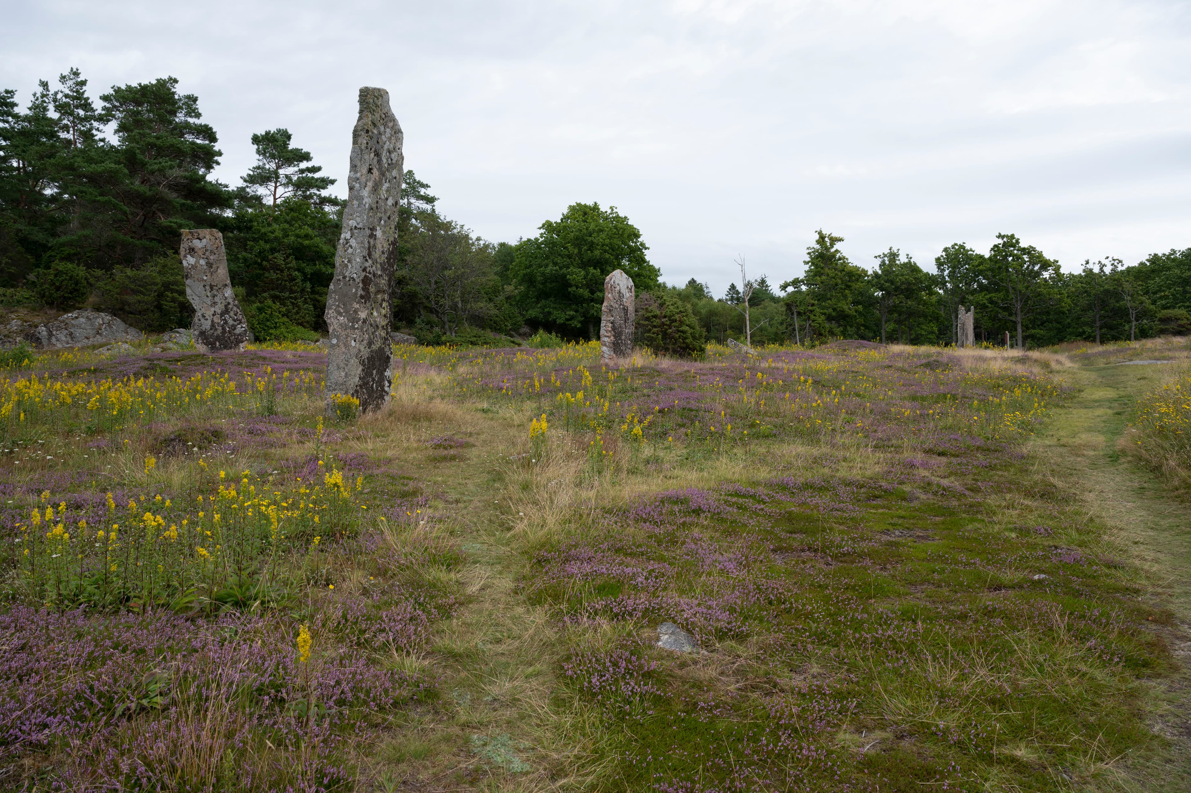
On a coastal hillside north of Grebbestad, more than two hundred Iron Age graves spread across the Bohuslan landscape, their burial mounds crowned by standing stones that rise up to four and a half metres above the earth. This is the largest grave field in Bohuslan, dating to the Migration Period around 400-500 AD, where a prosperous trading community honored its dead with monumental stone markers visible from both land and sea.
Greby grave field covers a hillside north of Grebbestad with the accumulated dead of an Iron Age trading community. Over two hundred graves, dating to the Migration Period around 400-500 AD, spread across the terrain in varied forms: sixty-eight round mounds, fifty-four long mounds, forty-seven round stone settings, twelve oval stone settings, and approximately twenty-eight standing stones, some reaching four and a half metres in height. The sheer density of burial monuments creates a landscape dominated by the dead.
For centuries, local legend held that these were the graves of Scottish warriors who invaded Tanum and raided as far as Bullaren, twenty-five kilometres inland, before the people of Bohuslan defeated them and buried them here. When Oscar Montelius, one of Sweden's most distinguished archaeologists, excavated eleven of the graves in June 1873, he found no weapons. Instead, the cremation burials contained glass pearls, bone combs, bronze fittings, and other personal items suggesting a peaceful trading community with connections to Norway, England, and Germany.
The contrast between legend and evidence tells its own story. The tall standing stones, called bautastenar, would have been visible from the sea approaches as well as from the surrounding land. They were not markers of fallen warriors but memorials to the dead of a prosperous coastal settlement, people whose lives were shaped by trade rather than warfare. The glass pearls came from far away. The combs were finely crafted. These were people of substance, honored with the most durable material their community could offer: stone.
The grave field occupies ground that in the Migration Period would have been closer to the sea, the ancient shoreline having retreated since. The dead were placed at a boundary between land and water, a threshold that Norse cosmology recognized as charged with meaning. Today the sea is farther away, but the standing stones still mark the horizon, vertical interruptions in the coastal landscape that declare the presence of the dead to anyone who approaches.
Context and lineage
The Greby community buried its dead on this hillside during the Migration Period, roughly 400-500 AD. They cremated the deceased, placed the burnt bones in clay pots, and buried them beneath mounds of earth or within stone settings. For graves of particular importance, they erected standing stones, bautastenar, that rose above the burial mounds like declarations visible across the landscape and from the sea.
For generations, the local story was different. Legend held that Greby was the resting place of Scottish warriors who had invaded Tanum, raiding as far inland as Bullaren before the people of Bohuslan fought back and defeated them. The tall standing stones were read as warrior markers, fitting the narrative of a great battle and its aftermath.
In June 1873, Oscar Montelius arrived to excavate eleven of the graves. What he found overturned the legend entirely. No weapons. No shields. No evidence of warfare. Instead: glass pearls, bone combs, bronze fittings, pieces of clay urns containing cremated remains. The dead of Greby were traders, not warriors, connected by commerce to Norway, England, and Germany.
Greby belongs to the broader tradition of Iron Age monumental burial in Scandinavia, where standing stones and cairns marked the graves of significant community members. The site's location in the Tanum area places it within one of Scandinavia's richest archaeological landscapes, which includes the UNESCO World Heritage Bronze Age rock carvings at Vitlycke. The transition from the earlier Bronze Age rock art tradition to the Migration Period burial practices at Greby reflects the evolution of sacred landscape use across millennia on the Bohuslan coast.
Oscar Montelius
Distinguished Swedish archaeologist who excavated eleven graves at Greby in June 1873, debunking the Scottish warrior legend
Why this place is sacred
The thinness at Greby operates through accumulation rather than singularity. No single grave here is the most elaborate or the most ancient in Bohuslan. What sets Greby apart is the sheer number of the dead and the visual impact of their markers.
Walking among the standing stones, you encounter them as individual presences before you grasp the collective scale. Each bautasten rises from a burial mound like a declaration, some barely a metre tall, others reaching four and a half metres, their surfaces weathered by sixteen centuries of salt air and rain. They do not form a pattern visible from ground level. They seem placed individually, each one honoring a specific grave, a specific person. Only from higher ground or in photographs does the full density of the field become apparent: hundreds of burial markers concentrated in a single hillside, the accumulated memorials of a community spanning generations.
The atmosphere shifts with light and weather. On overcast days, when the Bohuslan coastal fog moves inland, the standing stones emerge from the mist like figures, and the resemblance to a gathered crowd becomes difficult to dismiss. In low-angled sunlight, each stone casts a long shadow that extends across neighboring graves, connecting the dead to one another in lines of darkness and light. In rain, the stones darken and glisten, and the quiet of the site deepens.
The legend of the Scottish warriors, though debunked by archaeology, contributes to the atmosphere in an unexpected way. Knowing that this story was told for generations, that people walked among these graves believing they were the resting places of defeated invaders, adds a layer of narrative presence to the physical landscape. The dead here carry not only their own identities but the identities that later generations projected onto them.
The former proximity to the sea adds another dimension. When these graves were made, the water was closer. The dead were buried at the edge of things, where the solid ground gave way to the shifting sea. Norse cosmology understood such boundaries as places of power and danger, thresholds where the membrane between worlds grew thin. The sea has retreated, but the threshold quality persists in the landscape's openness and the wind that moves through the standing stones.
A communal burial ground for an Iron Age trading settlement during the Migration Period (approximately 400-500 AD). The cremation burials with trade goods and the absence of weapons indicate a prosperous commercial community rather than a warrior society.
The grave field was used during the Migration Period and likely for some generations beyond. Local legend transformed it into the burial place of defeated Scottish raiders, a narrative preserved for centuries before Oscar Montelius's 1873 excavation revealed the peaceful trading character of the buried community. The site is now a protected cultural heritage monument and part of the broader Tanum archaeological landscape that includes the UNESCO-listed rock carvings.
Traditions and practice
The Migration Period community cremated their dead, placed the burnt bones in clay urns, and buried them within stone settings or beneath earthen mounds. Personal grave goods accompanied the dead: glass pearls, bone combs, bronze fittings, and other objects reflecting the individual's identity and connections. For graves of particular significance, tall standing stones were erected, requiring substantial communal effort to quarry, transport, and raise. The variety of grave types, including round mounds, long mounds, and stone settings of different shapes, suggests either evolving customs or social distinctions expressed through burial form.
No formal religious or ceremonial practices take place at the site. Greby is visited as an archaeological and historical monument. Some modern Nordic spiritual practitioners visit as part of broader engagement with Norse sacred landscapes, though no organized ceremonies are documented. The site is freely accessible for contemplative walking and quiet observation.
Enter the grave field without rushing toward any particular stone. Let the site reveal its scale gradually. Walk among the mounds and standing stones for ten or fifteen minutes before consulting the information board, allowing the physical presence of the monuments to establish itself before the historical narrative shapes your interpretation.
Choose one standing stone that draws your attention and spend time with it. Observe its surface, its height, the way it relates to the burial mound beneath it. Consider that this stone was raised by people who knew the person buried below, people who chose this specific stone and shaped it to stand permanently above their dead. The stone is a gesture of remembrance made material.
Walk to the edges of the grave field and look back across the full extent of the site. From the periphery, the concentration of burial monuments becomes most visible, and the sense of accumulated ancestral presence is strongest.
If time allows, combine Greby with a visit to the Vitlycke Museum and the UNESCO World Heritage rock carvings nearby. The Bronze Age carvings and the Iron Age graves, separated by roughly a thousand years, represent different chapters in the same landscape's sacred history.
Iron Age/Migration Period Burial Cult
HistoricalGreby represents one of the largest concentrations of Iron Age burials in western Sweden, with over two hundred graves dating to the Migration Period. The scale of the cemetery suggests it served a significant community, possibly associated with an important trading settlement. The tall standing stones, some reaching four and a half metres, indicate this was a place of considerable social and spiritual importance where the dead were honored with prominent markers visible across the landscape and from the sea.
The dead were cremated and their burnt bones placed in clay pots. Grave goods included glass pearls, bone combs, and personal items, notably without weapons, suggesting a trading rather than warrior community. Standing stones were erected over graves of particular significance, while other graves received round mounds, long mounds, or stone settings of varied form.
Norse Ancestor Veneration
HistoricalThe monumental standing stones and carefully arranged burial mounds reflect broader Norse and Germanic traditions of honoring the dead through visible landscape markers. The grave field's location near what was then a shallow bay connected to the sea placed the dead at a threshold between land and water, a symbolically charged boundary in Norse cosmology.
Cremation of the deceased followed by urn burial in stone-marked graves. The tall standing stones served as permanent markers of the dead, visible from the surrounding landscape and sea approaches, linking the community of the dead with the living settlement and trading post.
Experience and perspectives
The approach to Greby follows signs from the road between Tanumshede and Grebbestad. A parking area provides direct access to the grave field, which occupies a hillside open to the coastal landscape. There is no ticket office, no gate, no formal entrance. You walk from the car directly into the presence of the dead.
The standing stones announce themselves first. The tallest, at four and a half metres, are visible from the road. As you enter the field, shorter stones emerge from the grass between burial mounds, and the density of the site begins to reveal itself. Paths thread between the graves, but there is no single prescribed route. Move where the stones draw you.
Take time to observe the variety of grave forms. The sixty-eight round mounds represent one burial tradition, their profiles low and even. The fifty-four long mounds are a different shape entirely, elongated forms that suggest a different conception of the burial space. The round and oval stone settings, marking other graves, add geometric variety to the landscape. And threading through all of these, the standing stones rise at intervals, each one marking a grave of particular significance.
The information board at the site provides context about the 1873 excavation and the debunked Scottish warrior legend. Read it before or after walking the field, but give the stones themselves the first encounter. The experience of Greby is primarily physical and atmospheric: the wind off the Bohuslan coast, the weathered surfaces of sixteen-hundred-year-old stone, the quiet accumulation of grave after grave extending across the hillside.
For the most atmospheric visit, come in the early morning or late evening when the light falls at a low angle across the field. In these conditions, the standing stones cast long shadows across the burial mounds, and the site's quality of silent congregation becomes most pronounced.
The broader Tanum area rewards a longer visit. The UNESCO World Heritage rock carvings at Vitlycke, dating to the Bronze Age, are a short drive south and provide a deeper context for the region's prehistoric heritage.
Greby grave field is located north of Grebbestad in Tanum Municipality, Vastra Gotaland County. The site is signposted from the road between Tanumshede and Grebbestad. Free parking is adjacent to the grave field. The site is open and unfenced, accessible at all times.
Greby's standing stones have attracted interpretation for centuries, from folk legend to archaeological science to modern spiritual engagement. Each framework reveals different dimensions of a site whose dead have been spoken for by the living across sixteen hundred years.
Archaeologists recognize Greby as the largest Iron Age grave field in Bohuslan, dating to the Migration Period around 400-500 AD. Oscar Montelius's 1873 excavation of eleven graves established the site's dating and character, finding cremation burials with personal items rather than weapons. Modern scholarship interprets Greby as the burial ground of an important trading community with connections to Norway, England, and Germany, definitively debunking the traditional legend of Scottish warriors. The site's standing stones and diverse grave types reflect the social complexity of the Migration Period coastal community.
Local tradition held for generations that the grave field marked the final resting place of Scottish warriors who invaded and raided the Tanum region. This legend, though overturned by archaeology, reflects how communities create meaning around ancient monuments through storytelling and collective memory. The standing stones were read as warrior markers, the grave field as a battlefield memorial, long before scientific investigation revealed the peaceful trading character of the buried community.
Modern pagan and heathen communities view Greby as a significant sacred landscape connected to Norse ancestral traditions. The concentration of graves and standing stones is sometimes interpreted as creating a concentrated field of ancestral presence. The site's former coastal location at a sea inlet is understood as placing it at a liminal boundary between worlds, a threshold charged with spiritual significance in Norse cosmology.
Only eleven of over two hundred graves have been excavated, leaving the vast majority of the site archaeologically unexplored. Whether the standing stones bore carved symbols or images, now lost to sixteen centuries of weathering, remains unknown. The precise relationship between the grave field and the nearby trading settlement has not been fully established. What determined whether a grave received a tall standing stone, a small stone setting, or simply a mound is not understood, though social hierarchy is the most likely explanation.
Visit planning
Located north of Grebbestad, Tanum Municipality, Vastra Gotaland County. Signposted from the road between Tanumshede and Grebbestad. Free parking adjacent to the grave field. Freely accessible at all times. No admission charge.
Grebbestad offers hotels, guesthouses, and camping options. Tanumshede, slightly inland, provides additional accommodation and services.
Respect the site as an ancient burial ground. Do not climb standing stones or walk on burial mounds.
No specific dress requirements. Sturdy footwear recommended for the uneven grassland terrain. Weather-appropriate clothing essential on the exposed Bohuslan coast.
Photography is permitted throughout the site. The standing stones are particularly photogenic in low-angled light.
Do not leave objects at the site. Preserving the archaeological integrity of the grave field is essential.
Do not climb on standing stones or burial mounds. No digging or disturbing the archaeological remains. The site is protected under Swedish cultural heritage law (Kulturmiljolagen).
Plan your visit
Address
GREBY 10, 457 95 Grebbestad, Sweden
Hours
Hours, fees, and access can change — verify on the official source before you travel. Practical details last checked Jun 2026.
Nearby sacred places
Sacred places within a half-day’s reach. Pilgrims often visit them together: walk one, stay for the other.

Vrångstads Long Dolmen
Tanums kommun, Västra Götalands län, Sweden
21.7 km away

The rock carvings of Tanum
Sotenäs kommun, Västra Götalands län, Sweden
30.4 km away

Styrdalen Valla Dolmen
Kållekärr, Västra Götalands län, Sweden
78.1 km away
Borre Mound Cemetery
Horten, Vestfold og Telemark, Norway
88.2 km away
Key questions
What pilgrims usually ask
- Why is Greby grave field considered sacred?
- Walk among over two hundred Iron Age graves and towering standing stones at Bohuslan's largest burial ground near Grebbestad, Sweden.
- What should I wear at Greby grave field ?
- No specific dress requirements. Sturdy footwear recommended for the uneven grassland terrain. Weather-appropriate clothing essential on the exposed Bohuslan coast.
- Can I take photos at Greby grave field ?
- Photography is permitted throughout the site. The standing stones are particularly photogenic in low-angled light.
- How long should I spend at Greby grave field ?
- Forty-five minutes to one and a half hours to explore the full grave field at a contemplative pace.
- How do you visit Greby grave field ?
- Located north of Grebbestad, Tanum Municipality, Vastra Gotaland County. Signposted from the road between Tanumshede and Grebbestad. Free parking adjacent to the grave field. Freely accessible at all times. No admission charge.
- What offerings are appropriate at Greby grave field ?
- Do not leave objects at the site. Preserving the archaeological integrity of the grave field is essential.
- What etiquette should visitors follow at Greby grave field ?
- Respect the site as an ancient burial ground. Do not climb standing stones or walk on burial mounds.
- What is the history of Greby grave field ?
- The Greby community buried its dead on this hillside during the Migration Period, roughly 400-500 AD. They cremated the deceased, placed the burnt bones in clay pots, and buried them beneath mounds of earth or within stone settings. For graves of particular importance, they erected standing stones, bautastenar, that rose above the burial mounds like declarations visible across the landscape and from the sea. For generations, the local story was different. Legend held that Greby was the resting place of Scottish warriors who had invaded Tanum, raiding as far inland as Bullaren before the people of Bohuslan fought back and defeated them. The tall standing stones were read as warrior markers, fitting the narrative of a great battle and its aftermath. In June 1873, Oscar Montelius arrived to excavate eleven of the graves. What he found overturned the legend entirely. No weapons. No shields. No evidence of warfare. Instead: glass pearls, bone combs, bronze fittings, pieces of clay urns containing cremated remains. The dead of Greby were traders, not warriors, connected by commerce to Norway, England, and Germany.