Dunamuck South Stone Row
Paired stone sentinels aligned across Kilmartin Glen's ancient ceremonial floodplain
Kilmichael Glassary, Argyll and Bute, United Kingdom
Plan this visit
Practical context before you go
30-60 minutes for Dunamuck South alone. 1-2 hours to include the walk to Dunamuck North. A full day allows exploration of the wider Kilmartin Glen sacred landscape, including Temple Wood, Nether Largie, Ballymeanoch, and Dunadd.
Free open access at all times. Parking available at NR 84994 92222, near the A816. Walk north through a gate, cross a burn, and follow the footpath to the stones (10-15 minutes). The terrain is uneven and often boggy. Waterproof footwear is essential. The site is not wheelchair accessible. No public transport serves the immediate area; the nearest bus stops are in Lochgilphead (6 km south) or Kilmartin village (5 km north).
Dunamuck South is a scheduled ancient monument on working farmland. No active worship takes place. Visitors may walk freely to and around the stones. Respect the stones, the land, and the livestock. Leave no trace.
At a glance
- Coordinates
- 56.0752, -5.4577
- Type
- Stone Row
- Suggested duration
- 30-60 minutes for Dunamuck South alone. 1-2 hours to include the walk to Dunamuck North. A full day allows exploration of the wider Kilmartin Glen sacred landscape, including Temple Wood, Nether Largie, Ballymeanoch, and Dunadd.
- Access
- Free open access at all times. Parking available at NR 84994 92222, near the A816. Walk north through a gate, cross a burn, and follow the footpath to the stones (10-15 minutes). The terrain is uneven and often boggy. Waterproof footwear is essential. The site is not wheelchair accessible. No public transport serves the immediate area; the nearest bus stops are in Lochgilphead (6 km south) or Kilmartin village (5 km north).
Pilgrim tips
- No dress code. Practical outdoor clothing suits the terrain. Waterproof boots are essential, as the ground between the parking area and the stones is frequently boggy. Layers accommodate Scotland's changeable weather.
- Photography is freely permitted. The flat faces of the stones photograph well in raking light at dawn or dusk. Consider the alignment to Dunamuck North as a compositional element.
- The terrain is uneven and frequently waterlogged. Waterproof boots are essential. Close all gates behind you. Do not disturb the stones, the fallen stone, or the ground around them. Be aware of grazing livestock. The site is a scheduled monument; any interference is a criminal offense.
Overview
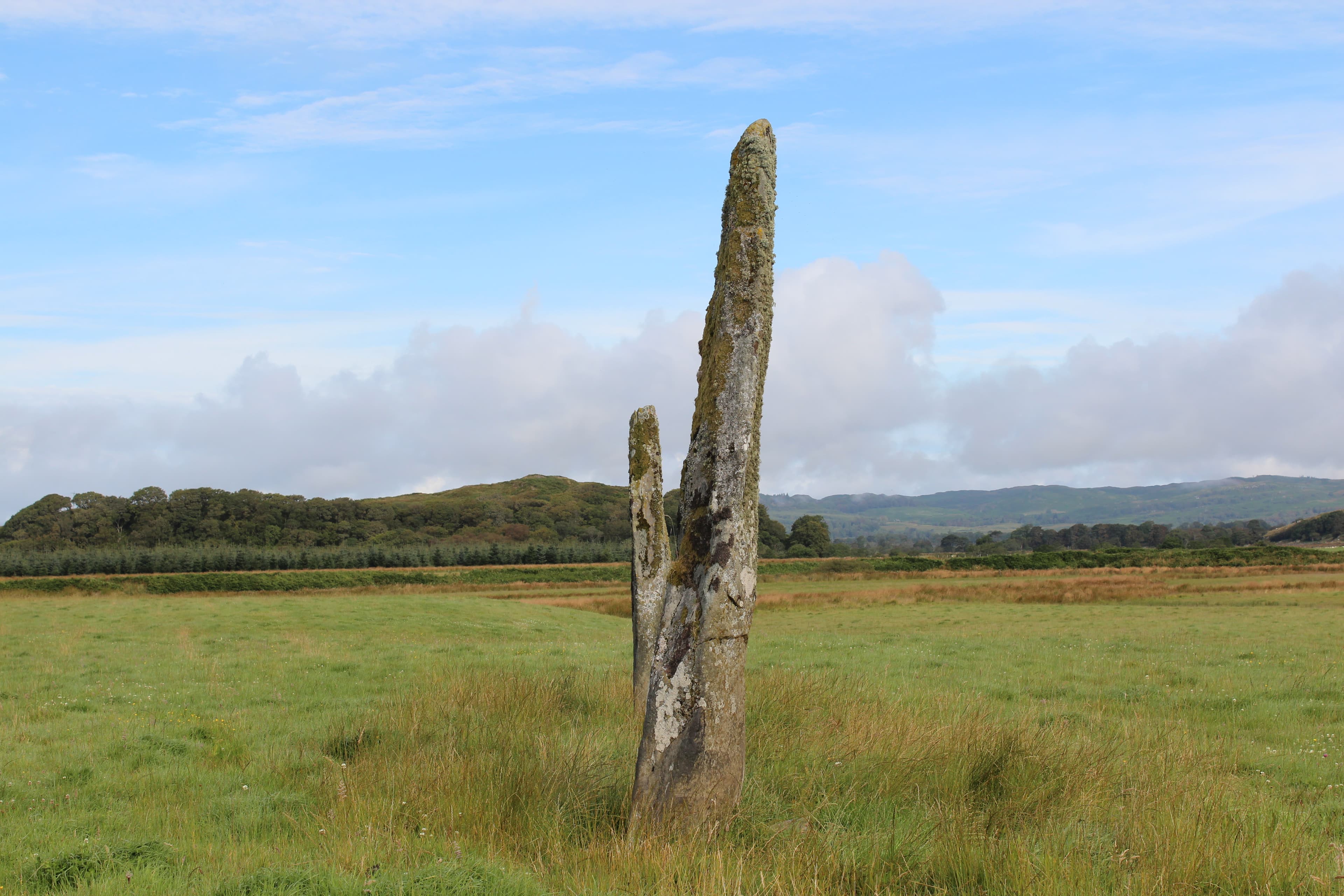
On level ground beside the River Add, two massive stone slabs stand where Bronze Age hands raised them four thousand years ago. Aligned on a NNW-SSE axis and visually linked to the Dunamuck North stone row across the fields, these stones participated in a network of ceremony that made Kilmartin Glen one of prehistoric Scotland's most significant ritual landscapes. Reaching them requires a walk across farmland that strips away expectation and returns the visitor to encounter.
The Dunamuck South stones stand on the western floodplain of the River Add, where the ground levels out between low hills and the water. Two great slabs rise from the grass, their longer faces oriented roughly NNW to SSE, with a third stone fallen between them. They are not tall in the way of Callanish or Brodgar, but they are broad and heavy, flat-sided slabs that suggest careful selection and deliberate placement. The stones were chosen for their shape as much as their size.
Looking northwest from the South group, the single tall orthostat of Dunamuck North is visible across the fields, aligned on the same axis. This visual and directional connection between the two groups was almost certainly intentional. Whatever ceremonies or observations took place here, they moved along this line, connecting point to point across the floodplain. The alignment may have referenced celestial events, marked territorial boundaries, or served purposes that cannot be recovered from stone alone.
Kilmartin Glen holds one of the densest concentrations of prehistoric monuments in mainland Scotland. Within six miles of the village, over 800 ancient monuments crowd the landscape, 150 of them prehistoric. Burial cairns march in a line through the valley. Stone circles stand in Temple Wood. Rock art spirals across exposed bedrock at Achnabreck. Dunadd Fort, where the kings of Dal Riata were inaugurated, rises on its rocky outcrop barely two kilometres away. The Dunamuck stones are quieter participants in this vast ceremonial geography, but their alignment and their weight testify to the same sustained devotion that produced the glen's more famous monuments.
Context and lineage
No origin narratives survive from the prehistoric builders. The name Dunamuck derives from the Gaelic Dun a' Mhuic, meaning 'fort of the pig,' referring to the nearby settlement rather than any mythology associated with the stones. The builders left no written language, no inscriptions, only the stones themselves and the alignment they still hold.
The lineage of Dunamuck South spans from anonymous Bronze Age builders through centuries of agricultural continuity to modern heritage protection. The communities who erected the stones left no names and no written records. Subsequent inhabitants of the glen, from Iron Age and Dal Riata settlers through medieval and modern farming communities, apparently left the stones undisturbed. The RCAHMS documented the site in the twentieth century. Historic Environment Scotland now protects it as a scheduled monument. Kilmartin Museum, redesigned and reopened in 2023, provides interpretive context for the broader landscape.
Unknown Bronze Age communities
RCAHMS surveyors
Why this place is sacred
Thinness at Dunamuck South arises from convergence rather than spectacle. The stones do not overwhelm with height or number. They stand instead with a steadiness that rewards attention. Their broad flat faces, oriented on the same axis as their northern counterpart, establish a directionality that the body instinctively follows. Something was meant to move along this line, whether eyes, feet, or understanding.
The approach contributes significantly. Unlike monuments accessible from car parks and paved paths, the Dunamuck stones require a walk across fields, a crossing of a burn, a passage through gates. Each step removes a layer of the habitual. By the time the stones appear ahead in the grass, the visitor has already begun to slow down, to notice the ground underfoot and the sky overhead, to become present in the landscape rather than merely passing through it.
The wider glen amplifies everything. Kilmartin was not casually inhabited. Over two millennia, its communities invested extraordinary labor in building cairns, circles, rows, and rock art across this valley. The Dunamuck stones participate in a landscape so dense with prehistoric meaning that every sightline connects monument to monument. Standing here, one stands within a web of intention that once structured an entire world.
The original purpose of the Dunamuck South stones cannot be established with certainty. Their alignment on a NNW-SSE axis, matching the Dunamuck North stone row, suggests astronomical, ceremonial, or territorial functions. The use of large flat slabs is characteristic of stone pairs across Argyll, generally dated to the Early Bronze Age. Whether the stones marked a processional route, framed observations of celestial phenomena, or served functions beyond modern reconstruction, the labor invested in quarrying, transporting, and erecting them indicates they mattered profoundly to their builders.
The Dunamuck South stones were erected during the Early Bronze Age, approximately 2500-1500 BCE, based on typological comparison with similar monuments. At some point, the central stone of the group fell or was toppled. No evidence survives of later modifications, additions, or reuse. The stones were first formally surveyed by the Ordnance Survey and later documented by the RCAHMS in their Argyll County Inventory. They are now a scheduled ancient monument, protected but unexcavated, standing much as they have for four thousand years.
Traditions and practice
Original Bronze Age practices remain unknown. The alignment of the stones and their visual connection to Dunamuck North suggest ceremonies involving movement along the NNW-SSE axis, possibly related to astronomical events. The use of large flat slabs, characteristic of Argyll stone pairs, may indicate specific ritual functions distinct from those of circular or single-stone monuments.
No formal ceremonies take place at Dunamuck South. Visitors engage through walking, contemplation, and photography. The site's isolation and absence of interpretation infrastructure encourage personal encounter rather than guided experience. Some visitors walk the connection between the South and North groups as an informal ritual of alignment.
Walk from the parking area rather than attempting to drive closer. Allow the approach across farmland to become part of the experience. Stand between the stones and look northwest along the alignment to Dunamuck North. Notice how the orientation creates a directionality that the body responds to. Sit with the stones if weather permits. Walk to Dunamuck North to experience the full axis. Return via the same route, noticing what the landscape reveals on the way back that it concealed on the way out.
Bronze Age Ceremonial
HistoricalThe standing stones were erected as part of a ritual landscape spanning Kilmartin Glen during the Early Bronze Age. Their alignment with Dunamuck North and their position within a valley containing hundreds of prehistoric monuments indicate participation in a sustained programme of ceremonial architecture. The use of large flat slabs, the NNW-SSE orientation, and the labour invested in their erection all point to profound significance within the belief system of their builders.
Unknown. The alignment of the stones suggests processional, astronomical, or territorial functions. The visual connection between the South and North groups implies ceremonies or observations that moved along the shared axis. The presence of cairns, stone circles, and rock art throughout Kilmartin Glen indicates a complex ritual landscape in which the Dunamuck stones played one role among many.
Experience and perspectives
The approach begins at a parking area near the A816, from which a footpath leads through a gate and north across a field. A small burn must be crossed. The path is well-marked but the ground is often wet, and waterproof boots are not optional. After a few minutes of walking, the two upright stones of the South group appear in the grass ahead, with the fallen stone lying between them.
The first impression is of weight. These are not slender pillars but broad, flat-sided slabs, their surfaces patterned with lichen in greens and greys. The most northerly stone stands over two and a half metres high; the southernmost reaches nearly three metres. They are set approximately four and a half metres apart, their longer axes oriented NNW to SSE. The fallen stone between them stretches over three and a half metres long, its displacement leaving a gap that may once have formed part of the alignment.
Standing between the stones and looking northwest, the single tall orthostat of Dunamuck North becomes visible across the fields. The alignment is unmistakable. Whatever connected these groups still connects them, visible in the shared orientation that four thousand years of weather, farming, and history have not disrupted.
The setting contributes to the experience. The River Add floodplain is flat and open, ringed by hills that create a natural enclosure. Sheep graze among the stones. The silence is genuine, broken only by birdsong and the sound of the burn. Visitors rarely encounter others here. This is not a famous monument but a quiet one, and its quietness is part of what it offers.
From the parking area at NR 84994 92222, walk north through the gate and across the field to the burn crossing at NR 84910 92315. Follow the footpath into the field containing the Dunamuck South stones. To continue to Dunamuck North, walk northwest along the field boundary to the farm track at NR 84580 92595, then head northeast approximately 350 metres to the visible standing stone. For the broadest understanding of the landscape, visit Kilmartin Museum before exploring the monuments.
Dunamuck South resists definitive interpretation. The stones hold their alignment without explaining it. Archaeological evidence establishes what was built and roughly when, but purpose and meaning remain genuinely uncertain. This honest uncertainty characterizes much of Kilmartin Glen, where the density of monuments far exceeds the surviving knowledge of what they meant.
Archaeological consensus places the Dunamuck stones within the Early Bronze Age monument tradition of Argyll, characterized by stone pairs and short stone rows using flat-sided slabs. The NNW-SSE alignment and the visual association with Dunamuck North indicate intentional directional connection between the two groups. The RCAHMS documented three groups of standing stones at Dunamuck, all on level ground beside the River Add. The stones have not been excavated, and no scientific dating has been published. Their dating rests on typological comparison with similar monuments elsewhere in Scotland and Britain, where radiocarbon dates from associated features generally fall between 2500 and 1500 BCE.
No continuous indigenous tradition survives from the prehistoric builders. The Gaelic place name Dun a' Mhuic refers to the nearby settlement. No folklore or oral tradition specifically associated with the Dunamuck stones has been recorded, a silence that reflects the depth of the break between the monument builders and all subsequent communities.
Some contemporary visitors interpret the alignment between the South and North groups as an energy line or ley. The concentration of monuments in Kilmartin Glen has attracted interest from those exploring sacred geography. The glen is frequently described as a 'thin place' in Celtic and contemporary spiritual frameworks. These interpretations cannot be confirmed or refuted by archaeological evidence.
Nearly everything about the Dunamuck South stones remains unknown beyond their physical characteristics. The precise date of erection, the identity of the builders, the function of the alignment, the reason for choosing this location, and the ceremonies or observations that took place here are all lost. The fallen central stone may have toppled naturally, been deliberately repositioned in prehistory, or been disturbed in historical times. No excavation has been conducted to answer these questions. The stones hold their positions and their silence equally.
Visit planning
Free open access at all times. Parking available at NR 84994 92222, near the A816. Walk north through a gate, cross a burn, and follow the footpath to the stones (10-15 minutes). The terrain is uneven and often boggy. Waterproof footwear is essential. The site is not wheelchair accessible. No public transport serves the immediate area; the nearest bus stops are in Lochgilphead (6 km south) or Kilmartin village (5 km north).
Limited accommodation nearby. Kilmartin Hotel offers rooms near the museum. More options in Lochgilphead (6 km south) and Oban (30 km north). For dawn visits, staying within the glen allows the most immersive experience.
Dunamuck South is a scheduled ancient monument on working farmland. No active worship takes place. Visitors may walk freely to and around the stones. Respect the stones, the land, and the livestock. Leave no trace.
No dress code. Practical outdoor clothing suits the terrain. Waterproof boots are essential, as the ground between the parking area and the stones is frequently boggy. Layers accommodate Scotland's changeable weather.
Photography is freely permitted. The flat faces of the stones photograph well in raking light at dawn or dusk. Consider the alignment to Dunamuck North as a compositional element.
Leaving offerings is not historically traditional at Dunamuck South. If moved to leave something, choose only natural, biodegradable materials that will not harm grazing animals. Consider whether leaving anything is appropriate at a site not associated with such practices.
Do not climb on or attempt to move the stones. Do not dig near the stones or disturb the fallen stone. The site is a scheduled ancient monument; damage or interference is a criminal offense. Respect any temporary fencing installed for conservation or agricultural purposes.
Plan your visit
Address
3GJQ+5F, Lochgilphead PA31 8RE, UK
Hours
Hours, fees, and access can change — verify on the official source before you travel. Practical details last checked Jun 2026.
Nearby sacred places
Sacred places within a half-day’s reach. Pilgrims often visit them together: walk one, stay for the other.
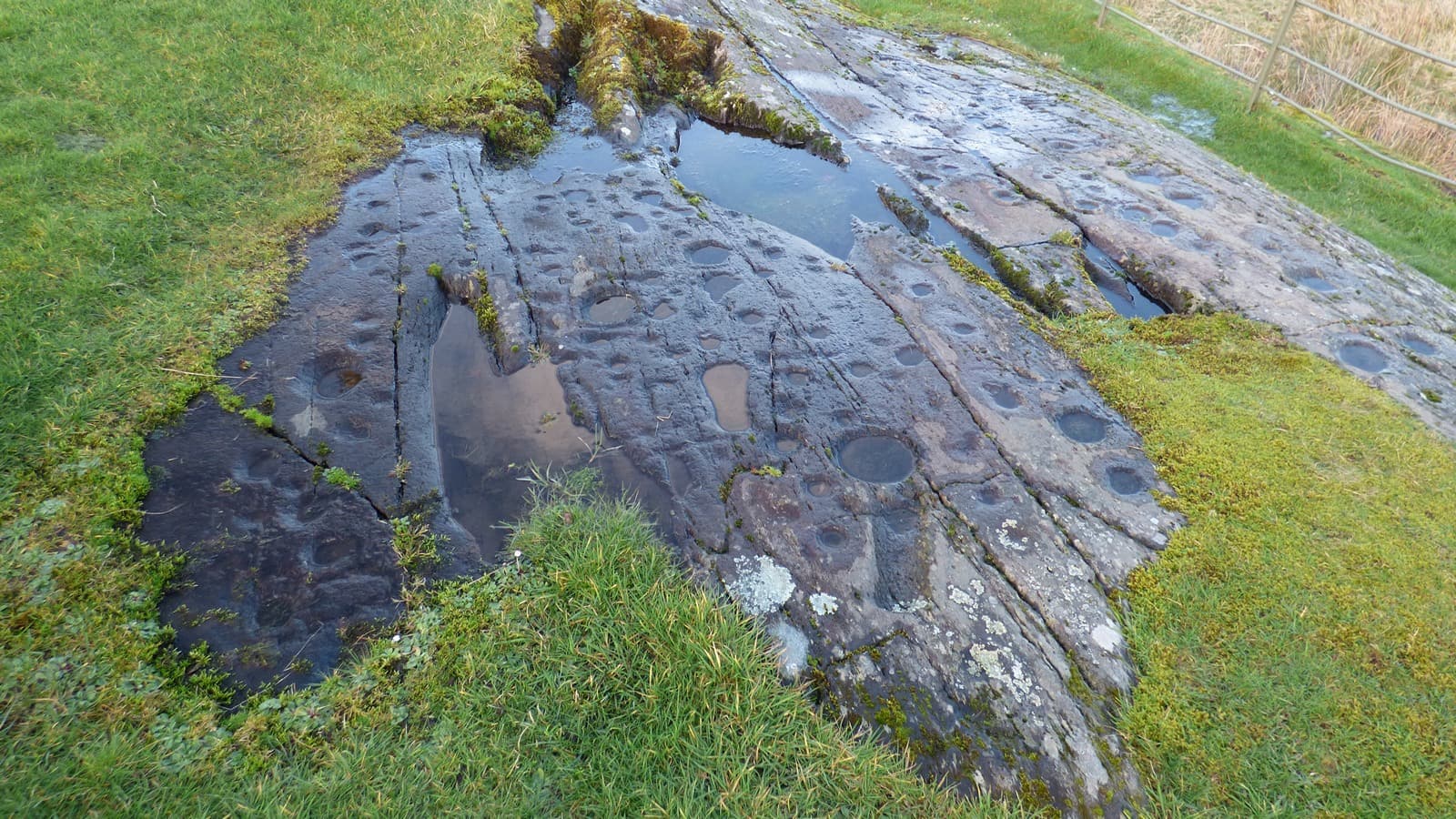
Kilmichael Glassary Cup and Ring Marks
Lochgilphead, Argyll and Bute, United Kingdom
1.4 km away
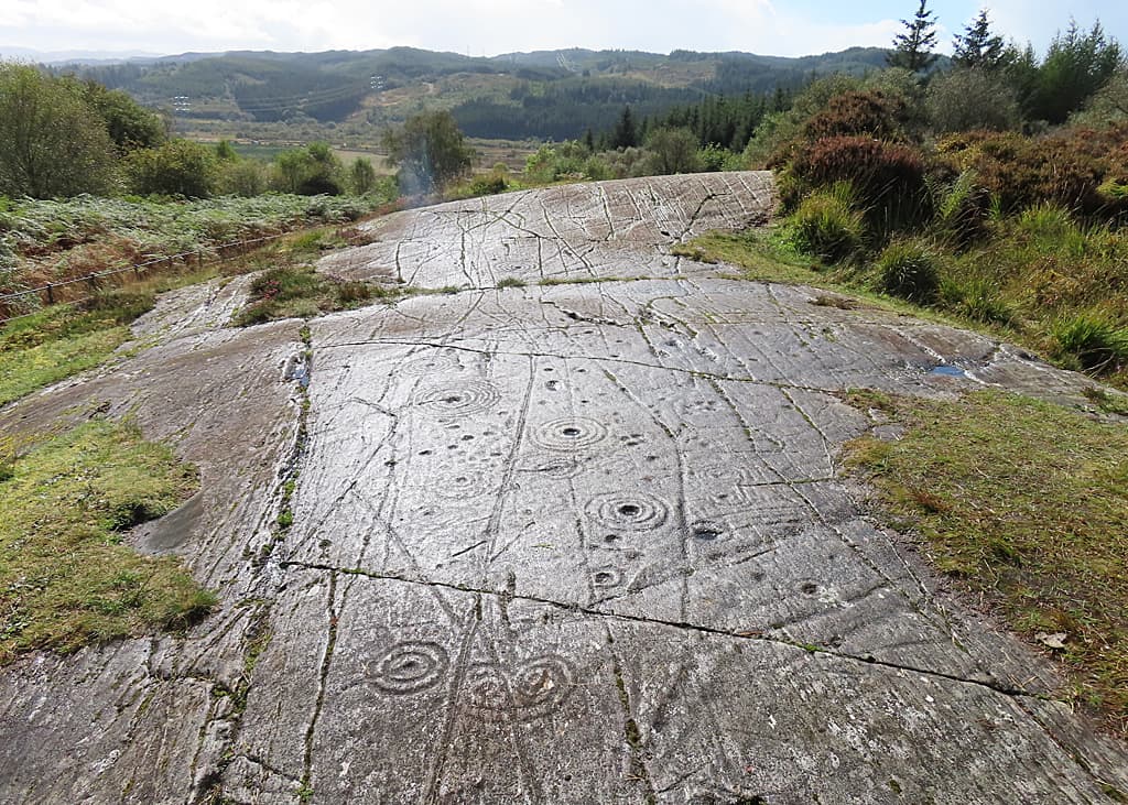
Achnabreck Rock Art Sites
Lochgilphead, Argyll and Bute, United Kingdom
1.8 km away

Dunadd sacred hill, Lochgilphead, Scotland
Bridgend, Scotland, United Kingdom
1.8 km away
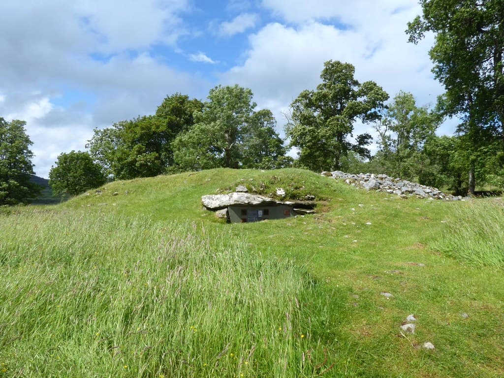
Dunchraigaig Cairn
Kilmartin, Argyll and Bute, United Kingdom
4.8 km away
References
Sources consulted when researching this page. Independent verification by readers is welcome.
- 01Dunamuck - Canmore (National Record of the Historic Environment) — Historic Environment Scotland / Canmorehigh-reliability
- 02WoSAS PIN 4174 - Dunamuck — West of Scotland Archaeology Servicehigh-reliability
- 03Kilmartin Museum — Kilmartin Museumhigh-reliability
- 04Dunamuck 2 - Canmore — Historic Environment Scotland / Canmorehigh-reliability
- 05Dunamuck, North - The Stone Rows of Great Britain — The Stone Rows of Great Britain
- 06Dunamuck, Two Standing Stones - Ancient Monuments UK — Ancient Monuments UK
- 07Dunamuck North - The Megalithic Portal — The Megalithic Portal
- 08Kilmartin Glen - Wikipedia — Wikipedia contributors
- 09Dunamuck N - The Modern Antiquarian — The Modern Antiquarian
- 10Kilmartin Glen - Sacred Scotland — Sacred Scotland
Key questions
What pilgrims usually ask
- Why is Dunamuck South Stone Row considered sacred?
- Visit the ancient Dunamuck South standing stones in Kilmartin Glen, Argyll. Bronze Age stone pair aligned across Scotland's richest prehistoric landscape.
- What should I wear at Dunamuck South Stone Row?
- No dress code. Practical outdoor clothing suits the terrain. Waterproof boots are essential, as the ground between the parking area and the stones is frequently boggy. Layers accommodate Scotland's changeable weather.
- Can I take photos at Dunamuck South Stone Row?
- Photography is freely permitted. The flat faces of the stones photograph well in raking light at dawn or dusk. Consider the alignment to Dunamuck North as a compositional element.
- How long should I spend at Dunamuck South Stone Row?
- 30-60 minutes for Dunamuck South alone. 1-2 hours to include the walk to Dunamuck North. A full day allows exploration of the wider Kilmartin Glen sacred landscape, including Temple Wood, Nether Largie, Ballymeanoch, and Dunadd.
- How do you visit Dunamuck South Stone Row?
- Free open access at all times. Parking available at NR 84994 92222, near the A816. Walk north through a gate, cross a burn, and follow the footpath to the stones (10-15 minutes). The terrain is uneven and often boggy. Waterproof footwear is essential. The site is not wheelchair accessible. No public transport serves the immediate area; the nearest bus stops are in Lochgilphead (6 km south) or Kilmartin village (5 km north).
- What offerings are appropriate at Dunamuck South Stone Row?
- Leaving offerings is not historically traditional at Dunamuck South. If moved to leave something, choose only natural, biodegradable materials that will not harm grazing animals. Consider whether leaving anything is appropriate at a site not associated with such practices.
- What etiquette should visitors follow at Dunamuck South Stone Row?
- Dunamuck South is a scheduled ancient monument on working farmland. No active worship takes place. Visitors may walk freely to and around the stones. Respect the stones, the land, and the livestock. Leave no trace.
- What is the history of Dunamuck South Stone Row?
- No origin narratives survive from the prehistoric builders. The name Dunamuck derives from the Gaelic Dun a' Mhuic, meaning 'fort of the pig,' referring to the nearby settlement rather than any mythology associated with the stones. The builders left no written language, no inscriptions, only the stones themselves and the alignment they still hold.