Achnabreck Rock Art Sites
Scotland's largest prehistoric rock art, where five thousand years of carved mystery await in a quiet Argyll woodland
Lochgilphead, Argyll and Bute, United Kingdom
Plan this visit
Practical context before you go
Forty-five minutes allows a walk to the main outcrops and a basic viewing. One to two hours permits unhurried engagement with all the carved surfaces and time for contemplation. Those combining the visit with other Kilmartin Glen sites should allow a full day.
Signposted off the A816, approximately 2.5 km northwest of Lochgilphead. A forestry road leads east to a Forestry and Land Scotland car park. From the car park, a signed gravel trail leads 500m uphill to the carved outcrops. An accessible parking area is available further uphill, with an 800m gravel trail to one of the outcrops. The site is open 24 hours, 365 days, with free access.
Achnabreck is an open-access heritage site requiring basic respect for the ancient carvings, the natural environment, and other visitors. The site is managed by Historic Environment Scotland and asks visitors to leave no trace.
At a glance
- Coordinates
- 56.0609, -5.4456
- Type
- Rock Art
- Suggested duration
- Forty-five minutes allows a walk to the main outcrops and a basic viewing. One to two hours permits unhurried engagement with all the carved surfaces and time for contemplation. Those combining the visit with other Kilmartin Glen sites should allow a full day.
- Access
- Signposted off the A816, approximately 2.5 km northwest of Lochgilphead. A forestry road leads east to a Forestry and Land Scotland car park. From the car park, a signed gravel trail leads 500m uphill to the carved outcrops. An accessible parking area is available further uphill, with an 800m gravel trail to one of the outcrops. The site is open 24 hours, 365 days, with free access.
Pilgrim tips
- No specific dress code. Sturdy waterproof footwear is strongly recommended, as the forest trail and rock surfaces can be muddy and slippery. Layers are advisable for changeable west coast weather.
- Photography is freely permitted and encouraged. The carvings are best photographed in low raking light at dawn or dusk, or after rain when water fills the cup marks. Low-angle photography can reveal details invisible when viewed from above. Flash photography at night can also highlight the carved grooves. Professional or commercial photography should be arranged with Historic Environment Scotland.
- Do not touch the carvings with force, apply chalk or other substances to highlight them, or attempt to make rubbings. These methods, once common in archaeological documentation, cause cumulative damage to the rock surface. Photography, including at low angles, is a non-destructive way to capture the carvings and can reveal details invisible to the naked eye. The forest trail can be muddy and slippery, particularly after rain. Appropriate footwear is essential. The rock outcrops themselves may be slippery when wet.
Overview
On a series of natural rock outcrops in a forest above Kilmartin Glen, the most extensive prehistoric carvings in Scotland lie open to the sky. Concentric rings, spirals, and hollows were pecked into hard rock with quartz hammerstones over a period spanning nearly two thousand years. Their meaning has been lost entirely. What remains is the work itself, unmistakable in its intention and impenetrable in its purpose, asking nothing of the visitor except attention.
Five thousand years ago, someone knelt on this rock and began to hammer.
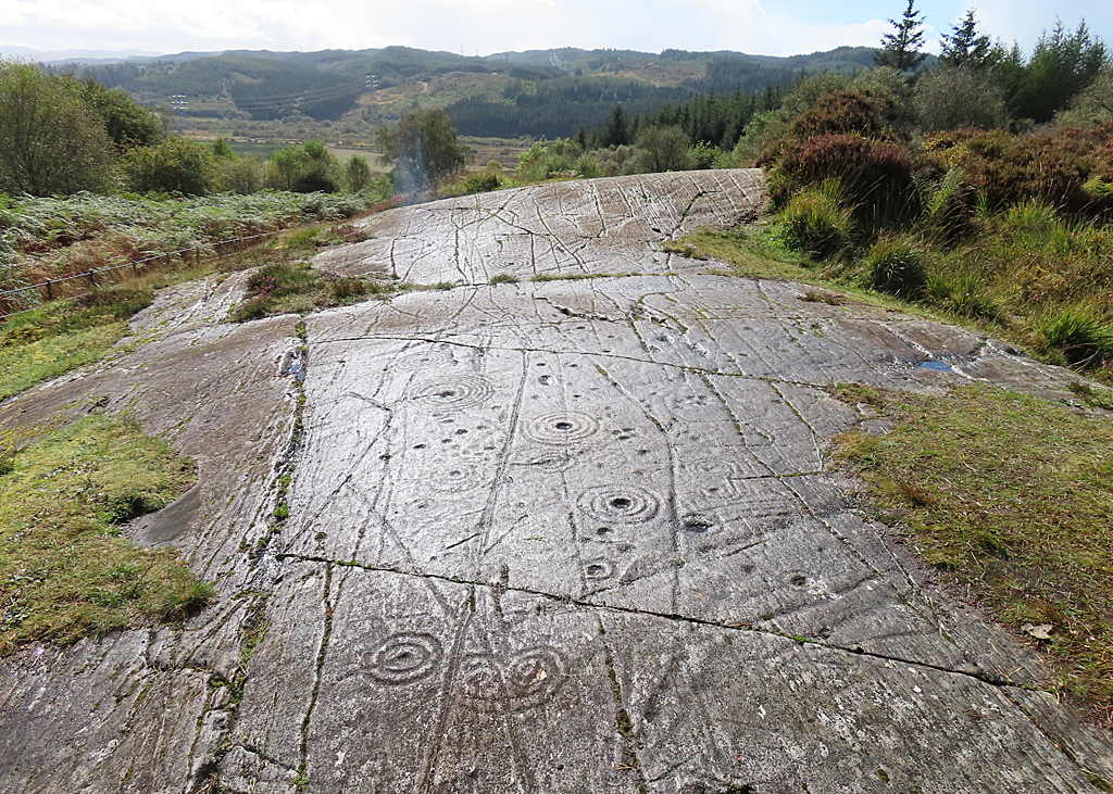
The tool was quartz, the surface was hard schist, and the work was slow. One cup mark at a time, one ring at a time, a circular groove deepening under repetitive blows until the stone held what the maker needed it to hold. Then another ring around the first, and another, and another, some motifs growing to more than a metre across with up to twelve concentric circles radiating outward like ripples frozen in stone.
Achnabreck is the largest and most elaborate rock art site in Scotland. Three main outcrops emerge from the forest floor, their surfaces covered with cup marks, cup and ring marks, spirals, and complex interlocking designs that resist every attempt at interpretation. The carvings belong to a tradition found across Atlantic Europe from Galicia to Scandinavia, but nowhere in Scotland are they more concentrated or more ambitious than here.
Recent photogrammetric analysis by Dr Aaron Watson has revealed something extraordinary beneath the familiar cup and ring marks: hundreds of previously unrecorded carvings in a style associated with Irish passage tomb art, later cut across and partially obscured by the cup and ring markings. The rock holds layers of meaning, one generation's sacred vocabulary overwritten by the next, each expressing something essential that the stone was asked to remember.
The site sits within Kilmartin Glen, one of the most concentrated prehistoric ceremonial landscapes in Britain, where over three hundred and fifty ancient monuments crowd into a six-mile stretch of valley. Achnabreck's carvings are part of that larger conversation between people and place, a conversation that began in the Neolithic and whose content we have entirely forgotten.
You can trace the rings with your eyes. You can wonder what they meant. You will not find an answer. The rock keeps its counsel, as it has kept it for five millennia.
Context and lineage
No origin narrative survives for Achnabreck. The people who created these carvings left no written record of any kind. What they left was the work itself, thousands of deliberate marks pecked into stone with quartz hammerstones whose fragments have been found scattered nearby.
The carvings belong to a tradition that spans Atlantic Europe. Similar cup and ring marks appear on rock surfaces from Galicia in northwest Spain to Scandinavia, with notable concentrations in Ireland, Scotland, northern England, and Brittany. This geographic spread suggests a shared symbolic language among Neolithic and Bronze Age communities connected by coastal trade and cultural exchange. Yet each site is distinct, and Achnabreck's carvings include motifs found nowhere else in Scotland.
The Gaelic name Achadh na Breac, 'field of the speckled stone,' tells us that by the time Gaelic-speaking communities named this place, the carvings had become a feature of the landscape rather than a living tradition. The marks were noticed but no longer understood.
Historic Environment Scotland's interpretation panels at the site suggest that the symbols may have had significance in rituals at a time when people believed that the landscape itself was alive and had powers of its own. This is as close to an origin story as we are likely to get, and it has the virtue of honesty about what we do not know.
The lineage at Achnabreck is not one of continuous practice but of continuous presence. The rock outcrops have been here far longer than any human tradition, and the carvings on their surfaces represent the most enduring human mark on this landscape.
The earliest known carvings, revealed by photogrammetry, share stylistic affinities with Irish passage tomb art dating to around 3000 BC. These were later overwritten by cup and ring marks of the kind found across Atlantic Europe, suggesting that different communities or different ritual practices succeeded one another at the site over centuries. By the Middle Bronze Age, around 1000 BC, the tradition of carving appears to have ceased.
The site then entered a long period as a feature of the landscape rather than a place of active use. Gaelic-speaking communities named it but left no record of any ritual connection. Modern archaeological attention began in the nineteenth century, and the site was placed in state care in 1895.
Today Achnabreck is cared for by Historic Environment Scotland and interpreted through the lens of archaeology and heritage conservation. But the carvings themselves predate all frameworks we bring to them. They were ancient before the pyramids were built, and they will outlast whatever meanings we assign them now.
Dr Aaron Watson
archaeologist
Archaeologist who used photogrammetric analysis to reveal hundreds of previously unrecorded carvings at Achnabreck, including passage-tomb-style art beneath the visible cup and ring marks. His work has fundamentally changed understanding of the site's complexity and chronology.
Scotland's Rock Art Project (ScRAP)
research project
National research initiative conducted in collaboration with Historic Environment Scotland, Edinburgh University, and Kilmartin Museum, systematically documenting and studying Scotland's rock art including the Achnabreck panels.
Why this place is sacred
What compels a person to spend days, perhaps weeks, pecking a metre-wide spiral into unyielding rock with a quartz pebble? Not decoration. Not idle time. Something essential enough to warrant the effort, and something shared widely enough to sustain a tradition across two thousand years and thousands of miles of Atlantic coastline.
The cup and ring marks of Achnabreck belong to one of the most widespread artistic traditions of prehistoric Europe, yet their meaning has vanished as completely as the people who made them. This is not the slow erosion of understanding that affects, say, a medieval cathedral whose symbolism has become obscure. This is total loss. We do not know whether the marks recorded events, encoded knowledge, accompanied rituals, marked territory, mapped the cosmos, or served purposes that have no equivalent in our vocabulary.
What we know is that the place itself mattered. The carvings were not scattered randomly across the landscape. They concentrated here, on these particular outcrops, in this particular valley, alongside hundreds of other monuments that together comprise one of prehistoric Britain's most remarkable ceremonial landscapes. The rocks were chosen. The location was chosen. The effort was chosen.
Dr Watson's photogrammetric discoveries add a temporal dimension to the mystery. Earlier carvings in a passage-tomb style lie beneath the cup and ring marks, meaning that one generation's sacred vocabulary was deliberately superseded by another's. The rock became a palimpsest of ritual intention, each layer speaking to the same stone but in a different language. This superimposition is rare at open-air rock art sites anywhere in Europe, making Achnabreck not only the largest but among the most complex rock art sites in Britain.
Visitors report a particular quality of stillness at the site. The forest enclosure, the exposed rock surfaces, the undeniable presence of ancient intention pecked into every visible surface, these combine to create a space where time seems to thicken. You are standing where others stood five thousand years ago, looking at marks they made for reasons you will never understand. The not-knowing is itself a kind of encounter.
Unknown. The carvings may have served cosmological, ceremonial, territorial, or memorial functions, or purposes that have no modern equivalent. The use of quartz hammerstones is noteworthy, as quartz held special significance in many prehistoric cultures. The site's location within a major ceremonial landscape suggests the carvings were part of a larger ritual system, though specific relationships between the rock art and nearby monuments remain unclear.
The photogrammetric evidence of superimposition tells a story of changing ritual vocabulary over centuries. Earlier motifs associated with Irish passage tomb art were partially overwritten by the cup and ring marks that dominate the visible surface today. This suggests that the site retained its sacred significance even as the symbolic language used to express that significance changed.
After the Bronze Age, the carvings appear to have passed out of active use. The Gaelic-speaking communities that later inhabited the area named the place Achadh na Breac, 'field of the speckled stone,' a description of appearance rather than significance. The carvings became archaeological curiosities rather than living symbols.
The site was placed in state care in 1895. Scotland's Rock Art Project, a collaboration between Historic Environment Scotland, Edinburgh University, and Kilmartin Museum, has undertaken systematic documentation of the carvings. Watson's photogrammetric analysis represents the most recent chapter, revealing that these familiar outcrops still hold secrets that five thousand years of exposure had not revealed to the naked eye.
Traditions and practice
The original practices are lost. What remains is archaeological evidence of process: quartz hammerstones used to peck the designs into the rock surface, motifs created over a period spanning roughly two thousand years, and the evidence of superimposition showing that later carvers deliberately marked over earlier ones. The presence of quartz is noteworthy, as this material held special significance in many prehistoric cultures and its use may indicate that the act of carving itself was ritualized rather than merely practical.
The wider Kilmartin Glen context provides some framework. The presence of burial cairns, stone circles, standing stones, and a fort alongside the rock art suggests a landscape in which different kinds of sacred activity were integrated. The rock art may have functioned within a system of ritual movement through the landscape, but this remains speculative.
No organized spiritual or ceremonial practices currently take place at Achnabreck. Visitors come for archaeological interest, photography, and personal contemplation. Some visitors report feeling a sense of presence or significance at the site, but this has not coalesced into any organized practice.
The site occasionally hosts guided walks organized by Historic Environment Scotland or Kilmartin Museum, which provide archaeological context for the carvings.
Achnabreck rewards slow attention. Rather than attempting to see everything quickly, choose one section of carved rock and spend time with it. Sit beside the outcrop if the ground permits. Let your eyes adjust to the surface. In certain light conditions, you may find that carvings you did not initially notice begin to emerge from what appeared to be blank stone.
Follow the concentric rings with your eyes, moving from the central cup outward through each successive ring. Consider the time and intention each ring required. Consider the hands that held the quartz hammerstones. Consider the purpose that justified the effort, even though that purpose is beyond your reach.
If visiting after rain, observe how water collects in the cup marks and traces the grooves. Some visitors find this the most evocative state of the carvings, when the marks become active participants in the landscape rather than passive records.
The forest setting supports silence. The site is rarely crowded. Use that solitude. Five thousand years of carved intention lie before you, and they ask nothing more than that you notice them.
Neolithic/Bronze Age Rock Art Tradition
HistoricalAchnabreck represents the culmination of a rock art tradition that spanned Atlantic Europe from approximately 3000 to 1000 BC. As the largest and most elaborate site in Scotland, it held a central place within whatever ritual or symbolic system the carvings served. The use of quartz hammerstones, the presence of passage-tomb-style art beneath later motifs, and the site's location within Kilmartin Glen's extraordinary concentration of monuments all point to sustained and deep significance.
The specific practices are unknown. The carvings were created by pecking the rock surface with quartz hammerstones, a process requiring considerable time and effort for each motif. The evidence of superimposition suggests evolving practices over centuries, with one symbolic vocabulary replacing another at the same sacred location. The presence of both simple cup marks and elaborate multi-ring compositions may reflect different types of ritual activity or different levels of significance.
Experience and perspectives
The approach matters. A gravel trail leads through managed forest for five hundred metres, ascending gently from the car park. The trees close around you, filtering light and sound, creating a corridor of transition between the everyday world of the A816 and something older. When the outcrops emerge from the forest floor, the shift is palpable.
The first thing you notice is scale. These are not modest marks on portable stones. They are vast compositions spread across rock surfaces the size of rooms, some individual motifs exceeding a metre in diameter. The largest cup and ring mark in Scotland sits here, its concentric circles and radial grooves resembling a giant web cast in stone. Around it, dozens of other motifs crowd the surface, each one pecked into existence by hand.
The second thing you notice depends on the light. At midday in bright sun, the carvings can be surprisingly difficult to see. The rock surface appears almost smooth, and you wonder if you have found the right place. Then a cloud passes, or the sun drops lower, and suddenly the shadows fill the carved grooves and the entire outcrop comes alive with pattern. This transformation is itself part of the experience. The carvings seem to appear and disappear, to breathe with the changing light, as though the rock chooses when to reveal itself.
After rain, the cup marks fill with water, becoming shallow pools that reflect the sky. The concentric rings around them become channels, miniature water courses connecting pool to pool. In this state the carvings are unmistakable, and their resemblance to ripples radiating from a point of impact becomes visceral.
Three main outcrops await, each with its own character. Move between them slowly. The temptation to photograph everything and move on is strong but resists rewarding. Choose one motif and sit with it. Trace the rings with your eyes. Notice how many there are, how regular, how the grooves vary in depth. Consider the hands that made them, the hours they required, the purpose they served. You will not discover that purpose. But you may discover something about what it means to attend to something you do not understand.
Begin at the interpretation panel near the first outcrop. The information here provides archaeological context without claiming to explain what the carvings mean. From here, move to the outcrops in whatever order feels natural.
The largest and most elaborate carvings occupy the two main contiguous rock faces, measuring roughly thirteen metres by six metres and eight metres by five and a half metres. These contain the most complex motifs, including the largest cup and ring mark in Scotland.
If you have time, walk the wider trail through the forest, where additional carved outcrops can be found. These satellite panels tend to be quieter and less visited, offering a more solitary encounter.
Return in different light conditions if you can. Dawn and dusk produce the raking light that reveals the carvings most dramatically. After rain is another optimal time. The same rock surface can look entirely different under different conditions, and each visit reveals details that previous visits missed.
Achnabreck accommodates multiple frameworks of understanding without yielding to any of them. The carvings are too old, too numerous, and too enigmatic for any single interpretation to contain them. Archaeologists, art historians, and spiritual seekers each bring genuine insight, and each honestly acknowledge the vastness of what remains unknown.
Archaeological consensus recognizes Achnabreck as the largest and most elaborate prehistoric rock art site in Scotland. The carvings are broadly dated to the Late Neolithic and Middle Bronze Age, approximately 3000 to 1000 BC, based on stylistic comparisons and the dating of comparable sites. The two main contiguous rock faces measure 12.8 metres by 6.0 metres and 8.2 metres by 5.5 metres, bearing seventeen and nine cup and ring marks respectively, with most having radial grooves and up to six concentric rings.
Dr Aaron Watson's photogrammetric analysis has significantly expanded scholarly understanding. His discovery of passage-tomb-style art beneath the cup and ring marks demonstrates that the site was carved over an extended period with changing symbolic vocabularies. This evidence of superimposition is exceptionally rare at open-air rock art sites and suggests a complexity of use and meaning that was not previously suspected.
The meaning of the carvings remains the central scholarly question. Proposed interpretations include astronomical records, territorial markers, ritual symbols, cosmological maps, and representations of altered states of consciousness. None has achieved consensus, and many scholars regard the question as potentially unanswerable given the absence of any associated text or continuous tradition of interpretation.
No indigenous tradition of interpretation survives for Achnabreck. The Gaelic name Achadh na Breac describes the appearance of the rock surface rather than any understanding of the carvings' significance. This complete loss of meaning, rather than being a failure, speaks to the depth of time involved. These marks were ancient before the Gaelic language existed.
Historic Environment Scotland's interpretation suggests the symbols may have had significance in rituals at a time when people believed the landscape itself was alive and had powers of its own. This framing acknowledges what we do not know while honoring the evident significance the site held for its creators.
The cup and ring marks of Achnabreck have attracted various alternative interpretations. Some see them as maps of consciousness or representations of entoptic phenomena, the geometric patterns seen during altered states of consciousness. Others interpret the concentric rings as representations of cosmic structure, sound waves, or energy patterns emanating from significant points in the landscape.
The motifs' resemblance to ripples in water has led to interpretations connecting them with springs, rainfall, and water worship. The fact that cup marks fill with rainwater and the grooves channel that water between them has been cited as support for this theory.
These interpretations remain speculative. Their value lies less in their accuracy, which cannot be tested, than in their recognition that the carvings were meaningful to their creators in ways that may not map onto modern categories of understanding.
Genuine mysteries persist at Achnabreck. Why this particular rock surface, in this particular landscape, attracted such intensive carving over such a long period remains unexplained. The relationship between the rock art and the other monuments of Kilmartin Glen, the cairns, standing stones, stone circles, and fortifications, is unclear.
The passage-tomb-style art discovered beneath the cup and ring marks raises new questions about connections between Achnabreck and the great Irish passage tombs of Newgrange, Knowth, and Dowth. Were the same people responsible? Did ideas travel along Atlantic trade routes? Was the earlier art style deliberately overwritten, or had it simply been forgotten by the time the cup and ring carvers arrived?
Perhaps most fundamentally, we do not know whether the cup and ring marks constitute a language, a record, a prayer, a map, or something for which we have no word. The carvings are manifestly intentional and manifestly significant. Their meaning is manifestly lost. Whether future technology or methodology will recover any of it, or whether some human endeavors are simply beyond the reach of retrospective understanding, remains to be seen.
Visit planning
Signposted off the A816, approximately 2.5 km northwest of Lochgilphead. A forestry road leads east to a Forestry and Land Scotland car park. From the car park, a signed gravel trail leads 500m uphill to the carved outcrops. An accessible parking area is available further uphill, with an 800m gravel trail to one of the outcrops. The site is open 24 hours, 365 days, with free access.
Lochgilphead, 2.5 km south, provides a range of accommodation from hotels to guest houses. The village of Cairnbaan, closer to the site, has a hotel and self-catering options. Kilmartin village, 8 km north, offers accommodation near the museum. Those exploring the full Kilmartin Glen landscape should consider staying in the area for two or more days.
Achnabreck is an open-access heritage site requiring basic respect for the ancient carvings, the natural environment, and other visitors. The site is managed by Historic Environment Scotland and asks visitors to leave no trace.
No specific dress code. Sturdy waterproof footwear is strongly recommended, as the forest trail and rock surfaces can be muddy and slippery. Layers are advisable for changeable west coast weather.
Photography is freely permitted and encouraged. The carvings are best photographed in low raking light at dawn or dusk, or after rain when water fills the cup marks. Low-angle photography can reveal details invisible when viewed from above. Flash photography at night can also highlight the carved grooves. Professional or commercial photography should be arranged with Historic Environment Scotland.
Not traditional and not encouraged. The carvings are their own offering. If you feel compelled to leave something, make it internal, a moment of silence, a recognition of the hands that made these marks. Physical offerings accumulate and detract from the site's integrity.
Do not apply chalk, paint, wax, or any other substance to the rock surface. Do not make rubbings. Do not climb on the carved outcrops unnecessarily. These are Scheduled Ancient Monuments and damage to them is a criminal offense.
Plan your visit
Address
Lochgilphead PA31 8RE, UK
Hours
Hours, fees, and access can change — verify on the official source before you travel. Practical details last checked Jun 2026.
Nearby sacred places
Sacred places within a half-day’s reach. Pilgrims often visit them together: walk one, stay for the other.
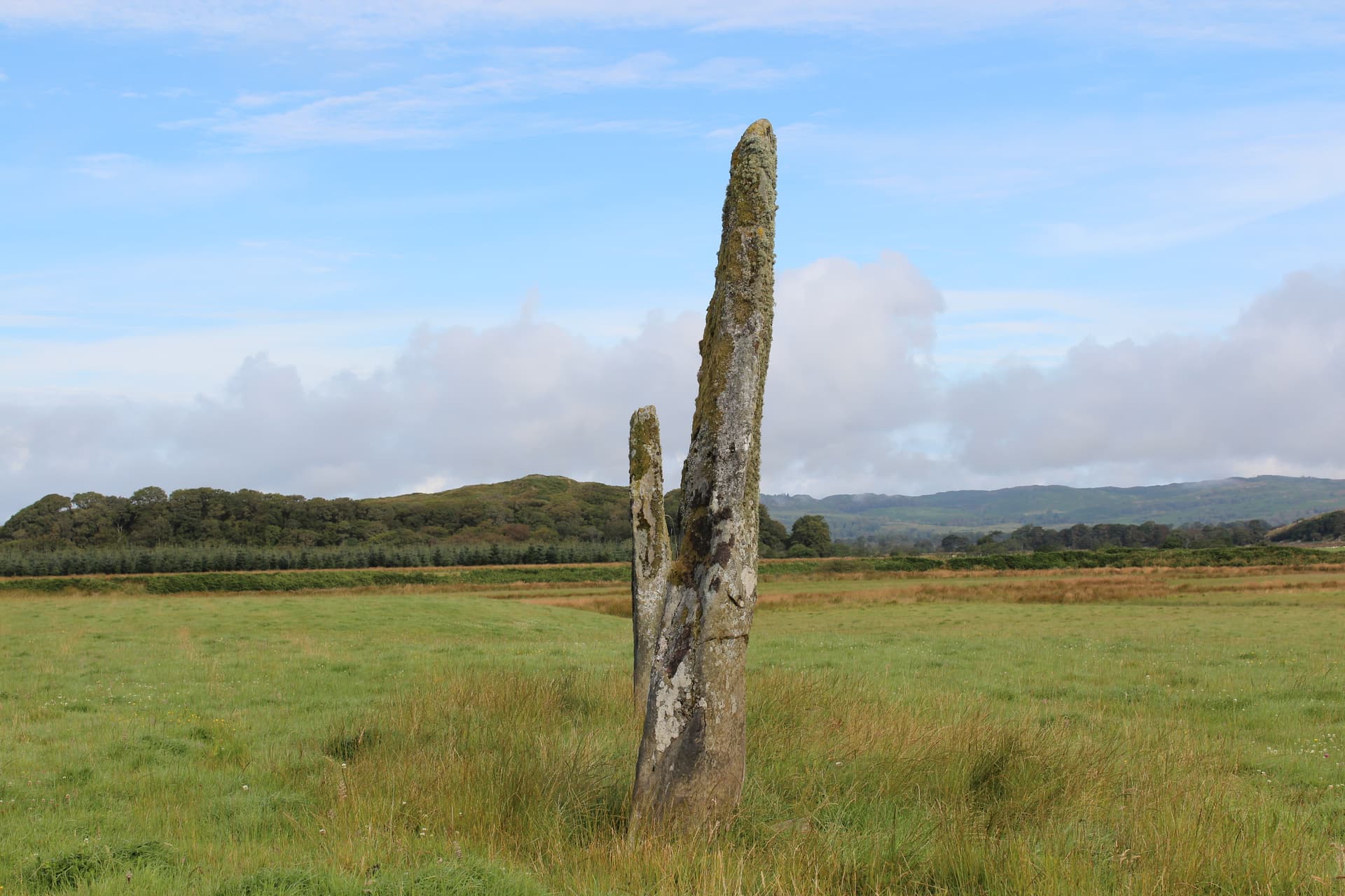
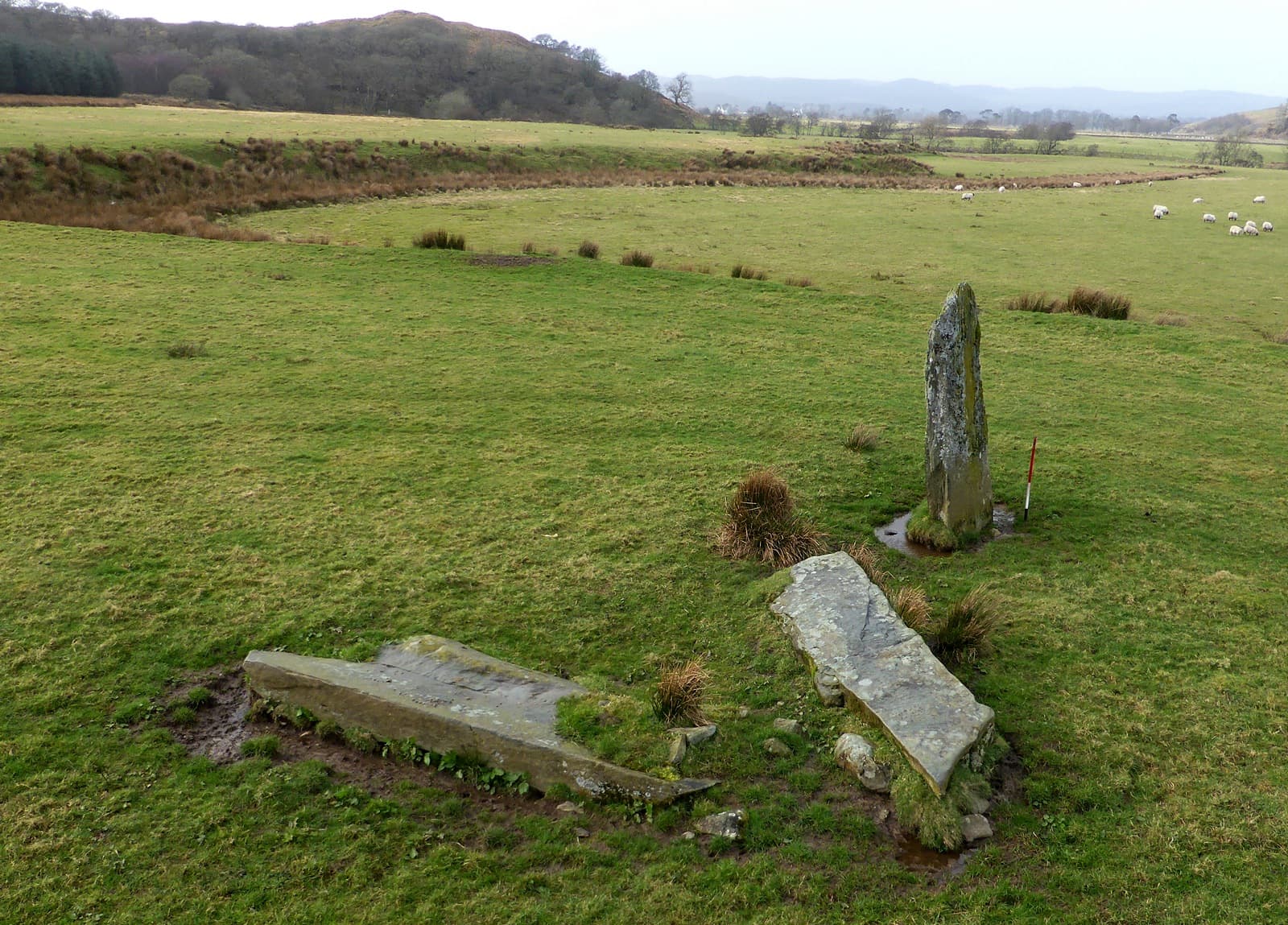
Dunamuck South Stone Row
Kilmichael Glassary, Argyll and Bute, United Kingdom
1.8 km away
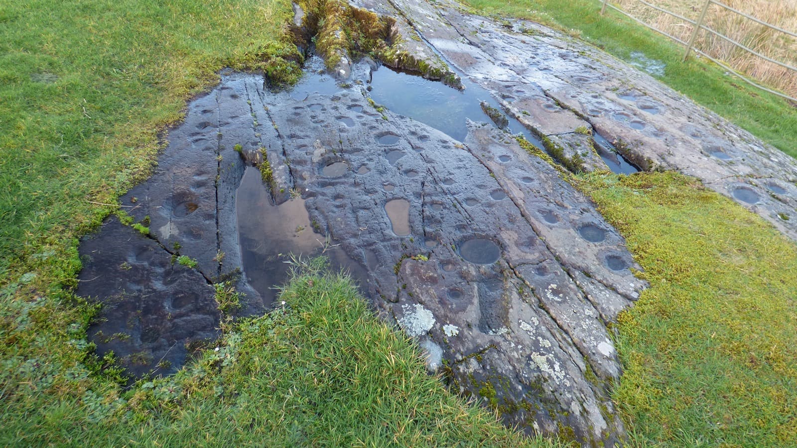
Kilmichael Glassary Cup and Ring Marks
Lochgilphead, Argyll and Bute, United Kingdom
2.8 km away

Dunadd sacred hill, Lochgilphead, Scotland
Bridgend, Scotland, United Kingdom
3.5 km away
Dunamuck North Stone Row
Kilmartin, Argyll and Bute, United Kingdom
6.3 km away
References
Sources consulted when researching this page. Independent verification by readers is welcome.
- 01Kilmartin Glen: Achnabreck Rock Art - Historic Environment Scotland — Historic Environment Scotlandhigh-reliability
- 02Achnabreck Cup and Ring Marks: History - Historic Environment Scotland — Historic Environment Scotlandhigh-reliability
- 03Achnabreck - Canmore National Record of the Historic Environment — Historic Environment Scotlandhigh-reliability
- 04Photogrammetry of Kilmartin Glen rock art — Dr Aaron Watsonhigh-reliability
- 05Scotland's Rock Art Project (ScRAP) — Historic Environment Scotland / Edinburgh Universityhigh-reliability
- 06Kilmartin Museum - Self-Guided Trail — Kilmartin Museumhigh-reliability
- 07Achnabreck Cup And Ring Marks - Wikidata — Wikidata contributors
- 08Prehistoric rock art at Achnabreck — The Hazel Tree
- 09Achnabreck Rock Art - The Megalithic Portal — The Megalithic Portal
- 10A Guide to the Achnabreck Rock Art in Argyll, Scotland — Loch Melfort Hotel
Key questions
What pilgrims usually ask
- Why is Achnabreck Rock Art Sites considered sacred?
- Discover Achnabreck, Scotland's most extensive prehistoric rock art site. Five-thousand-year-old cup and ring marks carved into rock in Kilmartin Glen, Argyll.
- What should I wear at Achnabreck Rock Art Sites?
- No specific dress code. Sturdy waterproof footwear is strongly recommended, as the forest trail and rock surfaces can be muddy and slippery. Layers are advisable for changeable west coast weather.
- Can I take photos at Achnabreck Rock Art Sites?
- Photography is freely permitted and encouraged. The carvings are best photographed in low raking light at dawn or dusk, or after rain when water fills the cup marks. Low-angle photography can reveal details invisible when viewed from above. Flash photography at night can also highlight the carved grooves. Professional or commercial photography should be arranged with Historic Environment Scotland.
- How long should I spend at Achnabreck Rock Art Sites?
- Forty-five minutes allows a walk to the main outcrops and a basic viewing. One to two hours permits unhurried engagement with all the carved surfaces and time for contemplation. Those combining the visit with other Kilmartin Glen sites should allow a full day.
- How do you visit Achnabreck Rock Art Sites?
- Signposted off the A816, approximately 2.5 km northwest of Lochgilphead. A forestry road leads east to a Forestry and Land Scotland car park. From the car park, a signed gravel trail leads 500m uphill to the carved outcrops. An accessible parking area is available further uphill, with an 800m gravel trail to one of the outcrops. The site is open 24 hours, 365 days, with free access.
- What offerings are appropriate at Achnabreck Rock Art Sites?
- Not traditional and not encouraged. The carvings are their own offering. If you feel compelled to leave something, make it internal, a moment of silence, a recognition of the hands that made these marks. Physical offerings accumulate and detract from the site's integrity.
- What etiquette should visitors follow at Achnabreck Rock Art Sites?
- Achnabreck is an open-access heritage site requiring basic respect for the ancient carvings, the natural environment, and other visitors. The site is managed by Historic Environment Scotland and asks visitors to leave no trace.
- What is the history of Achnabreck Rock Art Sites?
- No origin narrative survives for Achnabreck. The people who created these carvings left no written record of any kind. What they left was the work itself, thousands of deliberate marks pecked into stone with quartz hammerstones whose fragments have been found scattered nearby. The carvings belong to a tradition that spans Atlantic Europe. Similar cup and ring marks appear on rock surfaces from Galicia in northwest Spain to Scandinavia, with notable concentrations in Ireland, Scotland, northern England, and Brittany. This geographic spread suggests a shared symbolic language among Neolithic and Bronze Age communities connected by coastal trade and cultural exchange. Yet each site is distinct, and Achnabreck's carvings include motifs found nowhere else in Scotland. The Gaelic name Achadh na Breac, 'field of the speckled stone,' tells us that by the time Gaelic-speaking communities named this place, the carvings had become a feature of the landscape rather than a living tradition. The marks were noticed but no longer understood. Historic Environment Scotland's interpretation panels at the site suggest that the symbols may have had significance in rituals at a time when people believed that the landscape itself was alive and had powers of its own. This is as close to an origin story as we are likely to get, and it has the virtue of honesty about what we do not know.