Dunamuck North Stone Row
A solitary orthostat and fallen slabs aligned across Kilmartin Glen's ancient valley floor
Understand sacred places, explore living traditions, and learn how to engage respectfully with Pilgrim Map.
Access has not been verified. Check current local guidance before planning a visit.
Kilmartin, Scotland, United Kingdom
Read the sources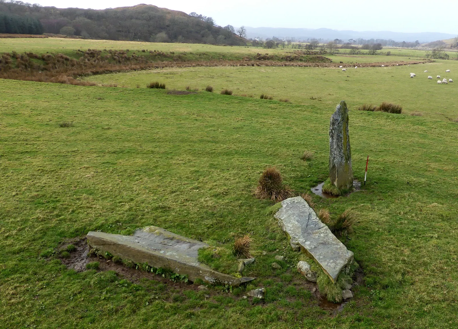
Image of Dunamuck North Stone Row. Image source · CC-BY-SA-2.0
Visit essentials
A quick read before you go
- Duration
- 20-40 minutes at the stone row itself, including the approach walk.
- Access
- From parking near Dunamuck (approximately NR 84994 92222), head north across the field.
Overview
Dunamuck North does not announce itself with a car park or heritage board. Visitors cross farmland on cattle-worn tracks until the tall orthostat appears as a dark vertical break in the grass and sedge, approaching as people have approached standing stones for four thousand years—with something between curiosity and recognition.
Three stones span just over seven meters. The tallest remains upright, weathered, lichen-covered, and rough beneath the hand; two companion slabs lie flat, their original positions debated but their presence deliberate. The NNW-SSE alignment points toward the Dunamuck South pair some distance away. The groups were almost certainly contemporary, linked by sight-line and purpose as one gesture across the landscape.
Kilmartin Glen holds more than eight hundred ancient monuments within a six-mile radius, over a hundred and fifty of them prehistoric. Stone circles, burial cairns, cup-marked rocks, henges, and hillforts record two millennia of ceremonial investment. Dunamuck North participates quietly, without Temple Wood's fame or Dunadd's elevation, asking only attention.
Why this place is sacred
The thinness of Dunamuck North resides partly in its obscurity. The better-known monuments of Kilmartin Glen draw most visitors: Temple Wood with its atmospheric stone circles, the Nether Largie cairns with their accessible burial chambers, Dunadd with its carved footprint and kingly associations. Dunamuck North receives far fewer visitors, and this relative neglect creates space for encounter. You are unlikely to share the site with anyone else.
The stones are yours, and the silence around them is yours, and the questions they raise have no interpretive panel to answer them.
The alignment between the North row and the South pair adds a spatial dimension to the thinness. These are not isolated monuments but partners in dialogue, their positions calculated to relate to each other across open ground. Standing at one and looking toward the other, you glimpse something of the prehistoric mind at work: the insistence that stones should not merely stand but should connect, forming lines and networks across the landscape.
What those connections meant remains unknown, but the intention is unmistakable.
There is also the matter of scale. The orthostat at 2.57 meters is taller than most people, and encountering a stone that exceeds your own height on open ground produces a specific physical response. You look up. The stone has stood here for roughly four thousand years, through every season and every weather, while everything around it has changed. That duration, apprehended physically rather than intellectually, is where the thinness lies.
The original purpose of Dunamuck North Stone Row remains unknown. Its classification as a Type S2 stone row places it within a recognized category of prehistoric monument, but the specific ceremonial, astronomical, or territorial function it served cannot be determined from the surviving evidence. The alignment with Dunamuck South suggests the two sites operated as part of a larger system, possibly involving processional movement or observation of celestial events.
The investment of labor in quarrying, transporting, and raising the stones indicates the monument held genuine importance for its builders.
Little is known about the evolution of Dunamuck North beyond its initial construction, likely during the Bronze Age. The two recumbent slabs may have originally stood upright and fallen at unknown dates, or they may have been deliberately placed in their current positions. The site does not appear in folk tradition or historical record in the way that some other Kilmartin monuments do. It has remained essentially static: a row of stones in a field, visited occasionally, disturbed minimally, enduring.
Experience and orientation
The approach sets the tone. From the nearest parking area, you head north across fields, joining a farm track that leads through working agricultural land. Sheep graze nearby. The ground can be wet underfoot, particularly after rain, and sturdy boots prove their worth within the first few minutes. The walk is not long, perhaps twenty minutes at a steady pace, but it creates a sense of intention. You are going somewhere specific, across ground that resists casual strolling.
The orthostat announces itself first. Rising above the grass, dark against the sky, it draws the eye from several hundred meters away. As you approach, the recumbent slabs come into view at its base, their flat surfaces disappearing into the turf. The row is modest in extent but not in presence. The standing stone commands its patch of ground with the authority of four millennia.
Touching the stone brings a shift in register. The surface is rough, cold, dense with the particular weight of geological time overlaid with human intention. Lichens pattern the face in subtle greys and greens. Looking along the alignment toward the south-southeast, the eye travels across open ground toward where the Dunamuck South stones stand, and the geometry of the ancient landscape becomes briefly legible.
The silence here is notable. Without the foot traffic of more popular sites, the soundscape belongs to wind, birds, and the occasional distant tractor. On still days, the quietness feels ancient, as though it has accumulated alongside the stones. Sitting among the monuments, letting time slow, visitors report a sense of the landscape holding them rather than the other way around.
The stone row lies northwest of Dunamuck farm, west of the River Add. From the parking area near Dunamuck, head north across the field toward the farm track. Follow the track northwest, then look for the standing stone visible to the northeast approximately 350 meters from the track. The row runs NNW-SSE. For full context, visit the Kilmartin Museum first, then explore the glen's monuments progressively.
Context and lineage
No origin narratives survive from the prehistoric builders of Dunamuck North. The stones predate written language in Scotland by many centuries. The name Dunamuck derives from Gaelic and refers to the settlement and surrounding land rather than any mythological association with the stone row. What survives is the physical evidence of deliberate placement: stones selected, transported, and arranged in a specific alignment within a landscape already dense with ceremonial monuments.
Dunamuck North Stone Row was created by anonymous Bronze Age communities whose identities and beliefs cannot be recovered. The monument appears to have had no subsequent ceremonial use in recorded history, distinguishing it from sites like Ballymeanoch where folk practices persisted into the modern era. Today it is managed as part of Scotland's archaeological heritage, a scheduled monument protected by law but not actively interpreted on site.
Its lineage is one of silence: built with purpose, then left to stand while the world around it transformed utterly.
Unknown Bronze Age peoples of western Scotland
Traditions and practice
The original Bronze Age practices associated with the stone row are unknown. The monument's alignment and its visual relationship with the Dunamuck South stone pair suggest ceremonial or astronomical functions, but no specific rituals can be reconstructed from the surviving evidence. Unlike some nearby sites, Dunamuck North does not appear in folk tradition with any recorded customs or practices.
No formal ceremonies or organized gatherings take place at Dunamuck North. Visitors come for archaeological interest, contemplation, and the experience of walking through a prehistoric landscape. Some engage in personal meditation or quiet reflection among the stones.
Walk slowly toward the stones rather than rushing. Allow the approach across farmland to build a sense of intention. When you arrive, spend time with each stone individually before considering the row as a whole. Look along the alignment toward Dunamuck South and notice how the monuments relate to each other across the landscape. Sit with the stones for a while. The quietness of the site rewards those who stay longer than the stones require to be seen.
Bronze Age Ceremonial
HistoricalThe stone row was erected as part of Kilmartin Glen's extensive prehistoric ceremonial landscape. The deliberate alignment and visual connection with the Dunamuck South stone pair indicate that these monuments participated in a larger system of ritual or observational purpose spanning the valley floor.
Unknown. The monument type and landscape position suggest possible ceremonial processions, astronomical observations, or territorial marking, but no specific practices can be reconstructed from the surviving evidence.
Perspectives and open questions
Dunamuck North Stone Row resists definitive interpretation. Archaeological classification provides a framework, but the specific purpose, beliefs, and experiences of its builders remain beyond recovery. The monument exists now as a question posed in stone, one that rewards contemplation precisely because it refuses easy answers.
Scholarly perspective
Archaeologists classify Dunamuck North as a Type S2 stone row within the gazetteer of British stone rows. No doubts have been expressed regarding its prehistoric interpretation. The visual alignment between the North row and the Dunamuck South stone pair strongly suggests the two sites were broadly contemporary and linked in purpose, forming part of the extraordinary density of ceremonial monuments in Kilmartin Glen.
The glen has been interpreted by scholars as a major ritual landscape, with good correlations documented between stone alignments and the rising and setting of the midwinter sun and the major standstill moon at other nearby sites. Whether these astronomical associations extend specifically to the Dunamuck stones has not been formally tested.
Living and traditional perspectives
No continuous traditional or indigenous interpretation survives for Dunamuck North. Unlike some Kilmartin monuments that attracted folk practices into the modern era, such as the betrothal customs at Ballymeanoch's holed stone, this stone row appears in no recorded folklore or oral tradition.
Alternative interpretations
Some contemporary visitors perceive the Kilmartin Glen landscape, including the Dunamuck monuments, as a network of spiritual energy or earth power. Ley line enthusiasts have noted alignments between various monuments in the glen. These interpretations cannot be verified against the archaeological record but represent ways in which modern seekers make meaning of genuinely mysterious remains.
Open questions
Nearly everything about the specific purpose of Dunamuck North remains unknown. Why were three stones placed in this particular alignment? Why does the row point toward the South stone pair? What ceremonies, observations, or beliefs animated the space between these monuments? Why did the builders choose this particular stretch of ground west of the River Add? The answers are not withheld by the stones; they were never inscribed there in any form recoverable by modern inquiry.
The mystery is genuine, and acknowledging it honestly is the most respectful response to what the builders left behind.
Plan your visit
Access and arrival
From parking near Dunamuck (approximately NR 84994 92222), head north across the field. Follow the farm track northwest to approximately NR 84580 92595, then look northeast for the standing stone visible roughly 350 meters away. The terrain is uneven and often boggy. Waterproof footwear is essential. The site is not wheelchair accessible.
Limited accommodation in the immediate area. Kilmartin Hotel offers rooms near the village. More options are available in Lochgilphead (approximately 6 km) and Oban (approximately 30 km). For immersive experience, staying nearby allows dawn and dusk visits.
Respectful visit
No dress code. Sturdy waterproof boots are essential as the ground is frequently boggy. Layers accommodate Scotland's changeable weather. Wind exposure on open ground can make temperatures feel considerably lower than forecast.
Freely permitted. Low-angle light at dawn or dusk produces the most dramatic results, casting long shadows from the orthostat. The alignment toward Dunamuck South can be captured effectively with a wide-angle lens.
Leaving offerings is not historically traditional at this site. If you feel moved to leave something, ensure it is natural, biodegradable, and will not harm grazing livestock.
Scheduled monument: damaging the site is a criminal offense under the Ancient Monuments and Archaeological Areas Act. Do not dig, remove stones or soil, or use metal detectors without permission from Historic Environment Scotland.
Respect the archaeological integrity of the monument. Do not attempt to move, excavate, or mark the stones. The site is a scheduled monument and any damage constitutes a criminal offense. Close gates behind you when crossing farmland and do not disturb livestock.
Current practical details
Address
3GJQ+5F, Lochgilphead PA31 8RE, UK
Hours
Hours, fees, and access can change — verify on the official source before you travel. Practical details last checked Jun 2026.
Location
Map loads as you approach this section.
Pilgrim reflections
A portrait of encounter, not a score
Pilgrims describe what they felt, how present they could become, and whether the place would shape a journey. There are no stars and no ranking of traditions.
No reviewed reflections yet
The first pilgrims can help describe the character of being here.
Share a reflection
Available after an account-backed “Been there.” Every reflection is reviewed before publication.
Nearby sacred places
Explore other sacred places in the region. Proximity does not establish access or travel time; check each place’s guidance.
References
Sources consulted for this page. Source categories describe the publication, not a guarantee that every claim is verified. Traditional accounts and outside interpretations may differ.
- 01Dunamuck, North - The Stone Rows of Great Britain — The Stone Rows of Great BritainofficialSpecialist gazetteer of British stone rows with detailed measurements and classification
- 02West of Scotland Archaeology Service - Dunamuck — WoSASofficialRegional archaeological service record
- 03Dunamuck, two standing stones, Mid Argyll — Ancient Monuments UKofficialScheduled monument database entry
- 04Recent astronomical observations at Kilmartin Glen, Argyll, Scotland — Antiquity JournalacademicAcademic journal article on astronomical alignments in Kilmartin Glen
- 05Cosmology and Bronze Age monuments - Scottish Archaeological Research Framework — ScARFacademicAcademic research framework on Bronze Age belief systems in Scotland
- 06Kilmartin Glen: Temple Wood Stone Circle - Historic Environment Scotland — Historic Environment ScotlandofficialOfficial Scottish heritage body; provides context for the wider Kilmartin Glen landscape
- 07Kilmartin Museum — Kilmartin MuseumofficialLocal specialist museum interpreting Kilmartin Glen's prehistoric landscape
- 08Kilmartin Glen - VisitScotland — VisitScotlandofficialOfficial Scottish tourism body
- 09Kilmartin Glen - Wikipedia — Wikipedia contributorsencyclopediaGeneral reference for the wider Kilmartin Glen context
- 10Kilmartin Glen Prehistoric Monuments - Atlas Obscura — Atlas ObscuraguideCultural travel guide with visitor perspective
- 11Kilmartin Glen, Near Oban, Argyll, Scotland — Historic UKSource contextHeritage information site with general Kilmartin Glen context
Share a photo
Help visitors recognize Dunamuck North Stone Row. Every submission is reviewed before publication.