Ri Cruin Cairn
The southernmost stone chamber in a four-thousand-year-old processional line of death and remembrance
Kilmartin, Argyll and Bute, United Kingdom

Plan this visit
Practical context before you go
15-30 minutes for the cairn alone. Allow 2-4 hours for the full linear cemetery walk from Kilmartin village. A full day permits exploration of the wider Kilmartin Glen landscape including Temple Wood, Ballymeanoch, and the cup-and-ring-marked rocks.
A signposted path leads approximately 200 metres from the public road to the cairn. The car park at the A816/B8025 junction near Temple Wood provides the nearest parking. Kilmartin Museum in the village offers a starting point for the monument trail. The path can be muddy in wet weather. The terrain is generally flat.
Ri Cruin is an open heritage site with no formal requirements. Respectful behaviour appropriate to an ancient burial place is expected. The cist slabs and carvings must not be touched or disturbed.
At a glance
- Coordinates
- 56.1171, -5.4995
- Type
- Cairn
- Suggested duration
- 15-30 minutes for the cairn alone. Allow 2-4 hours for the full linear cemetery walk from Kilmartin village. A full day permits exploration of the wider Kilmartin Glen landscape including Temple Wood, Ballymeanoch, and the cup-and-ring-marked rocks.
- Access
- A signposted path leads approximately 200 metres from the public road to the cairn. The car park at the A816/B8025 junction near Temple Wood provides the nearest parking. Kilmartin Museum in the village offers a starting point for the monument trail. The path can be muddy in wet weather. The terrain is generally flat.
Pilgrim tips
- No specific dress code. Sturdy waterproof footwear is recommended for the path. Layers and waterproofs are advisable in the Highland climate.
- Photography is permitted and encouraged. The axe-head carvings photograph best in low, raking light.
- This is a scheduled ancient monument and a burial site. The cist slabs and carvings must not be touched, climbed upon, or disturbed. The path can be muddy in wet weather. The carvings are subtle and may require careful looking to identify.
Overview
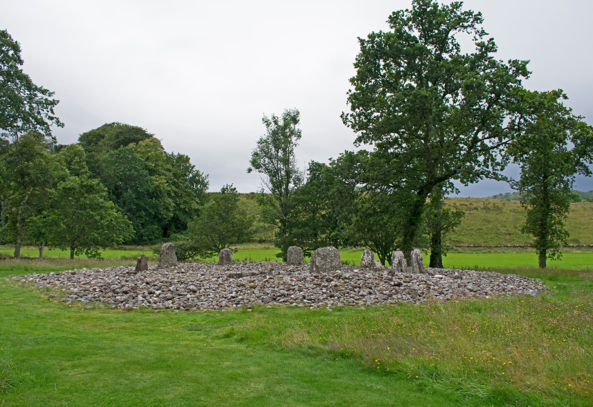
Ri Cruin Cairn stands at the southern end of Kilmartin Glen's linear cemetery, a two-kilometre alignment of Bronze Age burial cairns running through the floor of an Argyll valley. Its three stone-lined cists, exposed to daylight after millennia beneath a covering mound, still bear carvings of axe heads pecked into the slabs by hands that intended them for eternity. One cist held a carved pillar found nowhere else in north-western Europe.
The cairn sits among trees, two hundred metres from the road, at the terminus of something deliberate. Five burial cairns run north through Kilmartin Glen in a line that could not have been accidental. Ri Cruin is the last in the sequence, the final statement in a funerary alignment that took generations to complete.
What visitors see today are three stone-lined burial chambers, their covering mound removed to reveal the architecture of death as the Bronze Age understood it. The central cist was built first, approximately four thousand years ago, to receive a single individual of significant status. Two further burials followed, one added just outside the original kerb of stones. The slabs are grooved and rebated, fitted with a care that suggests the builders understood they were constructing something permanent.
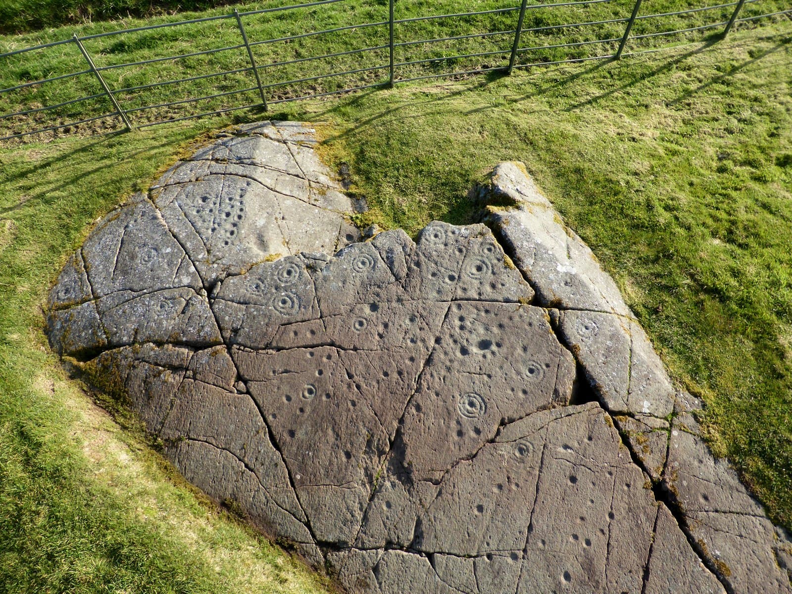
On the west end-slab of the southern cist, seven axe heads are pecked into the stone. These are not decoration. Bronze flat-axes were symbols of wealth and authority in Early Bronze Age Scotland, and their presence here speaks to the status of whoever was laid to rest in this chamber. The same motif appears at Nether Largie Mid and Nether Largie North cairns to the north, binding the linear cemetery together through shared symbolic language.
The cairn's most remarkable artifact is gone. A narrow vertical slab at the eastern end of the southern cist once bore a carving interpreted variously as a halberd with beribboned haft or a vessel to carry the dead to another world. This pillar was the only one of its kind from north-western Europe. It was removed to Poltalloch House, where it was destroyed in a fire. A cast survives in the National Museum of Scotland. What the carving meant to those who made it remains beyond recovery.
Context and lineage
No origin narrative survives from the Bronze Age builders. Local tradition holds that Ri Cruin is the burial place of a king, and the Gaelic name may reflect this association. The linear cemetery as a whole suggests that successive generations of Bronze Age communities chose this glen as a place to mark death and status across the landscape. The first cairns in the alignment date to the late Neolithic, and construction continued through the Early Bronze Age, meaning the tradition persisted for perhaps a thousand years before it ceased.
The symbolic carvings offer fragmentary insight into belief. The axe-head motifs signify power and wealth. The halberd or boat carving on the lost pillar has been interpreted by archaeologist Aubrey Burl as possibly representing a vessel to carry the dead to another world, a belief attested in other prehistoric European cultures. Whether this interpretation is correct remains unknowable, but the carving's uniqueness in north-western Europe suggests it expressed something of singular importance to those who commissioned it.
Ri Cruin belongs to the funerary traditions of Bronze Age communities in western Scotland. These communities built cairns, cists, and ritual monuments across Kilmartin Glen over a span of approximately two thousand years. The tradition of marking the glen floor with burial monuments created a landscape of ancestral presence that successive generations maintained and extended. The axe-head carvings connect Ri Cruin to a symbolic vocabulary shared across the linear cemetery, suggesting cultural continuity among the communities who built these monuments.
Unknown Bronze Age individual
historical
The person buried in the central cist of Ri Cruin, the primary burial around which the cairn was constructed. The axe-head carvings and unique halberd pillar indicate this was an individual of exceptional status within the Kilmartin Glen communities.
Reverend Mapleton
historical
Conducted the first excavation of Ri Cruin in 1870, discovering three cists with grooved side-slabs and a small amount of cremated bone in the northernmost cist.
V. Gordon Childe
historical
One of the twentieth century's most influential archaeologists. Excavated Ri Cruin in 1936 and prepared the site for public access and display. His work shaped how the cairn is experienced by visitors today.
Aubrey Burl
historical
Archaeologist and author who suggested the carved pillar at Ri Cruin may depict a boat intended to carry the dead to another world, connecting the cairn to broader prehistoric European beliefs about death and afterlife journeys.
Why this place is sacred
The removal of the cairn's covering mound creates a peculiar intimacy. Where once these chambers were sealed beneath tonnes of gathered stone, enclosed in perpetual darkness, they now lie open to rain and light and the gaze of anyone who walks the path from the road. This exposure was not intended by the builders. They constructed these cists to be hidden, to shelter the dead in permanent darkness. The fact that we can look into them at all is an accident of agricultural destruction, lime-kiln building, and archaeological curiosity.
This produces a quality different from entering a passage tomb or standing beside a stone circle. At Ri Cruin, you look down into the place where a body once rested. The grooved slabs that held the covering stone are still in position. The axe carvings, intended to accompany the dead in darkness, now catch afternoon light. The boundary between the world of the living and the world of the dead, which these chambers were designed to maintain, has been breached.
The linear cemetery adds another dimension. Standing at Ri Cruin and looking north, the other cairns recede up the glen. The alignment is unmistakable. These communities understood landscape as narrative, and they wrote their dead into it across two kilometres of valley floor. Ri Cruin is the final sentence.
Ri Cruin was built as a high-status burial cairn. Its purpose was to receive and protect the remains of an individual of significant standing within the Bronze Age communities of Kilmartin Glen. The axe-head carvings and the unique halberd pillar indicate this was not an ordinary burial but a statement of power, status, and possibly belief about what follows death. The cairn's position as the southernmost monument in the linear cemetery suggests deliberate placement within a larger ritual scheme.
The cairn was built around 2200-1950 BC as a single burial. It was subsequently expanded with two additional cists, indicating ongoing use. In the 1700s, agricultural improvements damaged the site and a lime kiln was built into the cairn, destroying part of its structure. The Reverend Mapleton excavated in 1870, James Craw in 1929, and V. Gordon Childe in 1936, when the site was prepared for public access. The carved halberd pillar was removed to Poltalloch House at an unknown date and subsequently destroyed by fire. Today the cairn functions as a heritage monument managed by Historic Environment Scotland, visited by those walking the Kilmartin Glen monument trail.
Traditions and practice
The construction of Ri Cruin involved gathering stones to build the cairn mound, shaping and fitting slab stones for the central cist, and placing the body of the deceased within. Cremation was practiced for at least one of the subsequent burials. Axe-head motifs were pecked into the cist slabs as symbolic markers of the deceased's status. The unique halberd or boat carving was placed at the east end of the southern cist, perhaps oriented toward the rising sun or intended to accompany the dead on a final journey. The cairn was subsequently expanded with two additional cists, indicating the site remained significant to the community over an extended period.
Visitors walk the signposted path to view the exposed cists and their carvings. Many visit as part of the Kilmartin Museum monument trail, which connects the major prehistoric sites in the glen. The site attracts those interested in archaeology, prehistory, and Scotland's ancient landscapes. Kilmartin Museum, reopened in 2023 after major redevelopment, provides context and interpretation for the wider landscape.
Walk to Ri Cruin as part of the full linear cemetery trail, beginning at Kilmartin Museum and moving south. Arriving at Ri Cruin as the final cairn allows the alignment to accumulate its meaning. Spend time with the southern cist and its axe-head carvings. Consider what it meant to carve symbols of wealth and power onto the walls of a burial chamber that was intended to remain sealed in darkness. Notice the absence where the halberd pillar once stood. Let the trees and the enclosed setting slow your pace.
Bronze Age Funerary Tradition
HistoricalRi Cruin was a high-status burial within the Kilmartin Glen linear cemetery, one of the most significant funerary alignments in prehistoric Scotland. The axe-head carvings and unique halberd pillar indicate exceptional status for the primary burial. The cairn's construction and subsequent expansion with additional cists demonstrate ongoing community investment in the site over an extended period.
Construction of a stone-lined cist for the primary burial, covered by a cairn of gathered stones defined by a kerb. Cremation of at least one subsequent burial. Carving of symbolic axe heads and a unique halberd or boat motif onto cist slabs. Sequential addition of two further cists after the initial construction.
Kilmartin Glen Ritual Landscape
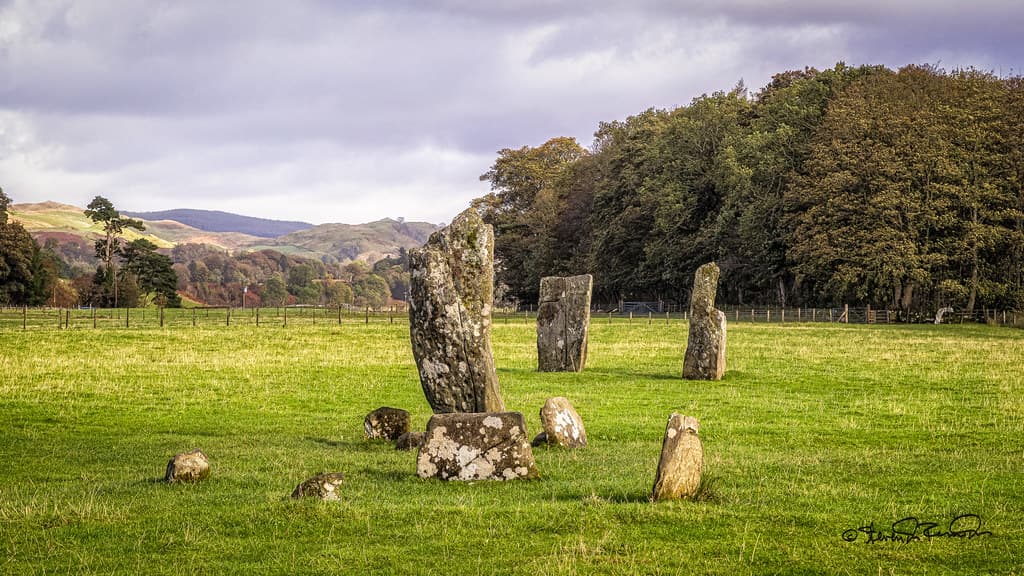
HistoricalRi Cruin is part of one of Britain's richest archaeological landscapes, with over 800 ancient monuments within a six-mile radius of Kilmartin village. The linear cemetery of five cairns, Temple Wood stone circles, Ballymeanoch standing stones, and extensive rock art together form a ritual landscape used for ceremony, burial, and status display across two thousand years. The density and variety of monuments suggest Kilmartin Glen held exceptional significance for the communities of western Scotland.
The construction of burial cairns, stone circles, standing stones, and carved rock panels across the glen over approximately two millennia. The linear alignment of cairns along the glen floor. The use of shared symbolic vocabulary, including axe-head carvings, across multiple monuments.
Experience and perspectives
The path from the road is signposted and leads through a stand of trees that separates the cairn from the open glen landscape. This transition matters. The other cairns in the linear cemetery sit in open fields with wide views. Ri Cruin is enclosed, sheltered, set apart. The trees create a threshold.
The cairn itself is modest compared to the reconstructed mounds at Nether Largie. Without its original stone covering, it reads as a low platform of stone with three rectangular openings. The cists are the focus. Each is a stone-lined chamber formed by upright slabs with grooves cut to receive covering stones. The craftsmanship is precise. These were not hastily assembled. The builders shaped and fitted these stones with intention and skill.
The southern cist draws the eye. On its west end-slab, seven axe heads are clearly visible, pecked into the stone surface four thousand years ago. They are small enough that a casual glance might miss them, but once seen they are unmistakable. Each represents a bronze flat-axe, the prestige object of its era. Their presence in a burial chamber speaks to what mattered most to these people when they laid their dead to rest.
The eastern end of the same cist once held the carved halberd pillar. It is gone. The space it occupied remains. This absence carries its own weight.
From Ri Cruin, looking north along the glen floor, the alignment of cairns is perceptible. Nether Largie South lies some four hundred metres away. Beyond it, the mid and north cairns, then the Glebe Cairn nearest Kilmartin village. The deliberateness of this arrangement becomes evident from the southern terminus. These communities inscribed their dead into the landscape with an intentionality that transcends individual burial.
Begin at the car park near the A816/B8025 junction, close to Temple Wood stone circles and Nether Largie South Cairn. Walk south to Ri Cruin via the signposted path. Alternatively, walk the full monument trail starting from Kilmartin Museum in the village, moving south through the linear cemetery to reach Ri Cruin as the final cairn. The southern approach provides the experience of following the alignment to its conclusion.
Ri Cruin Cairn sits within one of Scotland's most thoroughly studied archaeological landscapes, yet much about it remains beyond the reach of scholarship. The carvings speak, but in a language four thousand years removed from our own. Understanding the cairn means holding what is known alongside what cannot be recovered.
Archaeological consensus dates Ri Cruin to the Early Bronze Age, approximately 2200-1950 BC. Three excavations across sixty-six years (Mapleton 1870, Craw 1929, Childe 1936) established the sequence of construction: a primary central cist followed by two additional burials. The axe-head carvings are securely identified as representations of bronze flat-axes, symbols of status and wealth found at three cairns in the Kilmartin linear cemetery. The unique carved pillar, known only from a cast in the National Museum of Scotland after the original was destroyed by fire at Poltalloch House, remains debated. It has been variously interpreted as a halberd with beribboned haft, a ceremonial weapon, or a boat. Aubrey Burl proposed the boat interpretation, suggesting it represented a vessel for the dead. V. Gordon Childe's 1936 excavation prepared the site for its current presentation.
No living tradition claims Ri Cruin. Local Gaelic heritage associates the name with a royal burial, and the cairn is understood locally as part of a landscape of exceptional prehistoric significance. The broader Kilmartin Glen is recognized by Argyll communities as a place of deep ancestral presence, a landscape shaped by human intention across millennia.
Some visitors and writers perceive the Kilmartin Glen linear cemetery as aligned with earth energies or ley lines. The boat interpretation of the carved pillar connects to broader esoteric traditions about death as a voyage and prehistoric cultures' understanding of the transition between worlds. The concentration of ritual monuments in the glen has led some to identify it as a landscape of exceptional spiritual potency.
The identity of those buried in the three cists remains unknown. The meaning of the axe-head carvings to their makers, beyond a general association with status, is irrecoverable. The carved halberd pillar, destroyed by fire, can now only be studied from a cast, and its intended significance is a matter of interpretation rather than knowledge. The reason for the linear alignment of cairns through the glen floor, and whether it carried ritual or cosmological meaning beyond marking successive burials, belongs to the minds of people who left no written record.
Visit planning
A signposted path leads approximately 200 metres from the public road to the cairn. The car park at the A816/B8025 junction near Temple Wood provides the nearest parking. Kilmartin Museum in the village offers a starting point for the monument trail. The path can be muddy in wet weather. The terrain is generally flat.
Kilmartin village has limited accommodation including the Kilmartin Hotel. Lochgilphead (10 miles south) and Oban (25 miles north) offer wider options. The area is popular for self-catering holiday lets.
Ri Cruin is an open heritage site with no formal requirements. Respectful behaviour appropriate to an ancient burial place is expected. The cist slabs and carvings must not be touched or disturbed.
No specific dress code. Sturdy waterproof footwear is recommended for the path. Layers and waterproofs are advisable in the Highland climate.
Photography is permitted and encouraged. The axe-head carvings photograph best in low, raking light.
Not appropriate. Nothing should be left at or in the cists.
Do not touch or disturb the cist slabs, carvings, or cairn stones. Do not remove any material from the site. Dogs should be kept under control. The site is a Scheduled Monument protected by law.
Plan your visit
Address
1, B8025, Lochgilphead PA31, UK
Hours
Hours, fees, and access can change — verify on the official source before you travel. Practical details last checked Jun 2026.
Nearby sacred places
Sacred places within a half-day’s reach. Pilgrims often visit them together: walk one, stay for the other.
Nether Largie standing stones, Argyll, Scotland
Kilmartin, Alba / Scotland, United Kingdom
0.6 km away
Baluachraig Cup and Ring Marks
Kilmartin, Argyll and Bute, United Kingdom
0.6 km away
Temple Wood Stone Circle
Kilmartin, Argyll and Bute, United Kingdom
0.7 km away
Dunchraigaig Cairn
Kilmartin, Argyll and Bute, United Kingdom
0.8 km away
References
Sources consulted when researching this page. Independent verification by readers is welcome.
- 01Kilmartin Glen: Ri Cruin Cairn - Historic Environment Scotland — Historic Environment Scotlandhigh-reliability
- 02Ri Cruin Cairn: History - Historic Environment Scotland — Historic Environment Scotlandhigh-reliability
- 03Ri Cruin - Canmore (National Record of the Historic Environment) — Historic Environment Scotland / Canmorehigh-reliability
- 04Vere Gordon Childe and the Bronze Age cairn at Ri Cruin, Kilmartin, Argyll & Bute — National Museums Scotland Repositoryhigh-reliability
- 05Five remarkable prehistoric and early medieval finds from Kilmartin Glen — National Museums Scotlandhigh-reliability
- 06Self-Guided Trail - Kilmartin Museum — Kilmartin Museumhigh-reliability
- 07Scheduled Monument SM90247 - Ri Cruin — Historic Environment Scotlandhigh-reliability
- 08Ri Cruin Cairn Feature Page — Undiscovered Scotland
- 09Ri Cruin Cairn - Britain Express — Britain Express
- 10A walk to Rí Cruin Cairn — The Hazel Tree
Key questions
What pilgrims usually ask
- Why is Ri Cruin Cairn considered sacred?
- Visit Ri Cruin Cairn, a 4,000-year-old Bronze Age burial with rare axe-head carvings in Kilmartin Glen's linear cemetery, Argyll, Scotland.
- What should I wear at Ri Cruin Cairn?
- No specific dress code. Sturdy waterproof footwear is recommended for the path. Layers and waterproofs are advisable in the Highland climate.
- Can I take photos at Ri Cruin Cairn?
- Photography is permitted and encouraged. The axe-head carvings photograph best in low, raking light.
- How long should I spend at Ri Cruin Cairn?
- 15-30 minutes for the cairn alone. Allow 2-4 hours for the full linear cemetery walk from Kilmartin village. A full day permits exploration of the wider Kilmartin Glen landscape including Temple Wood, Ballymeanoch, and the cup-and-ring-marked rocks.
- How do you visit Ri Cruin Cairn?
- A signposted path leads approximately 200 metres from the public road to the cairn. The car park at the A816/B8025 junction near Temple Wood provides the nearest parking. Kilmartin Museum in the village offers a starting point for the monument trail. The path can be muddy in wet weather. The terrain is generally flat.
- What offerings are appropriate at Ri Cruin Cairn?
- Not appropriate. Nothing should be left at or in the cists.
- What etiquette should visitors follow at Ri Cruin Cairn?
- Ri Cruin is an open heritage site with no formal requirements. Respectful behaviour appropriate to an ancient burial place is expected. The cist slabs and carvings must not be touched or disturbed.
- What is the history of Ri Cruin Cairn?
- No origin narrative survives from the Bronze Age builders. Local tradition holds that Ri Cruin is the burial place of a king, and the Gaelic name may reflect this association. The linear cemetery as a whole suggests that successive generations of Bronze Age communities chose this glen as a place to mark death and status across the landscape. The first cairns in the alignment date to the late Neolithic, and construction continued through the Early Bronze Age, meaning the tradition persisted for perhaps a thousand years before it ceased. The symbolic carvings offer fragmentary insight into belief. The axe-head motifs signify power and wealth. The halberd or boat carving on the lost pillar has been interpreted by archaeologist Aubrey Burl as possibly representing a vessel to carry the dead to another world, a belief attested in other prehistoric European cultures. Whether this interpretation is correct remains unknowable, but the carving's uniqueness in north-western Europe suggests it expressed something of singular importance to those who commissioned it.