Yarrows Broch
The most complex broch in Caithness, standing on a loch-side promontory amid five thousand years of continuous human presence
Thrumster, Caithness, United Kingdom
Plan this visit
Practical context before you go
Two to three hours for the full archaeological trail circuit, including time at the broch and other monuments.
Signposted off the A99 at Thrumster, approximately ten kilometres south of Wick. Small parking area at OS grid reference ND306435. The trail crosses farmland on an informal path that can be very boggy. Not wheelchair accessible. No facilities at the site. Nearest town: Wick. Free access at all times. Very limited public transport; car access recommended. Nearest railway station: Wick.
Yarrows Broch is a Scheduled Ancient Monument freely accessible as part of the Yarrows Archaeological Trail. Respect for the monument fabric and practical preparation for the walk across farmland are the main requirements.
At a glance
- Coordinates
- 58.3744, -3.1843
- Type
- Broch
- Suggested duration
- Two to three hours for the full archaeological trail circuit, including time at the broch and other monuments.
- Access
- Signposted off the A99 at Thrumster, approximately ten kilometres south of Wick. Small parking area at OS grid reference ND306435. The trail crosses farmland on an informal path that can be very boggy. Not wheelchair accessible. No facilities at the site. Nearest town: Wick. Free access at all times. Very limited public transport; car access recommended. Nearest railway station: Wick.
Pilgrim tips
- Sturdy waterproof boots essential for the boggy terrain. Layered, windproof clothing advisable. No other specific requirements.
- Photography permitted throughout. The loch-side setting provides excellent opportunities, particularly in morning and evening light.
- The trail crosses farmland and can be very boggy in wet weather. Sturdy waterproof footwear is essential. Do not climb on fragile wall sections. Respect livestock and close gates.
Overview
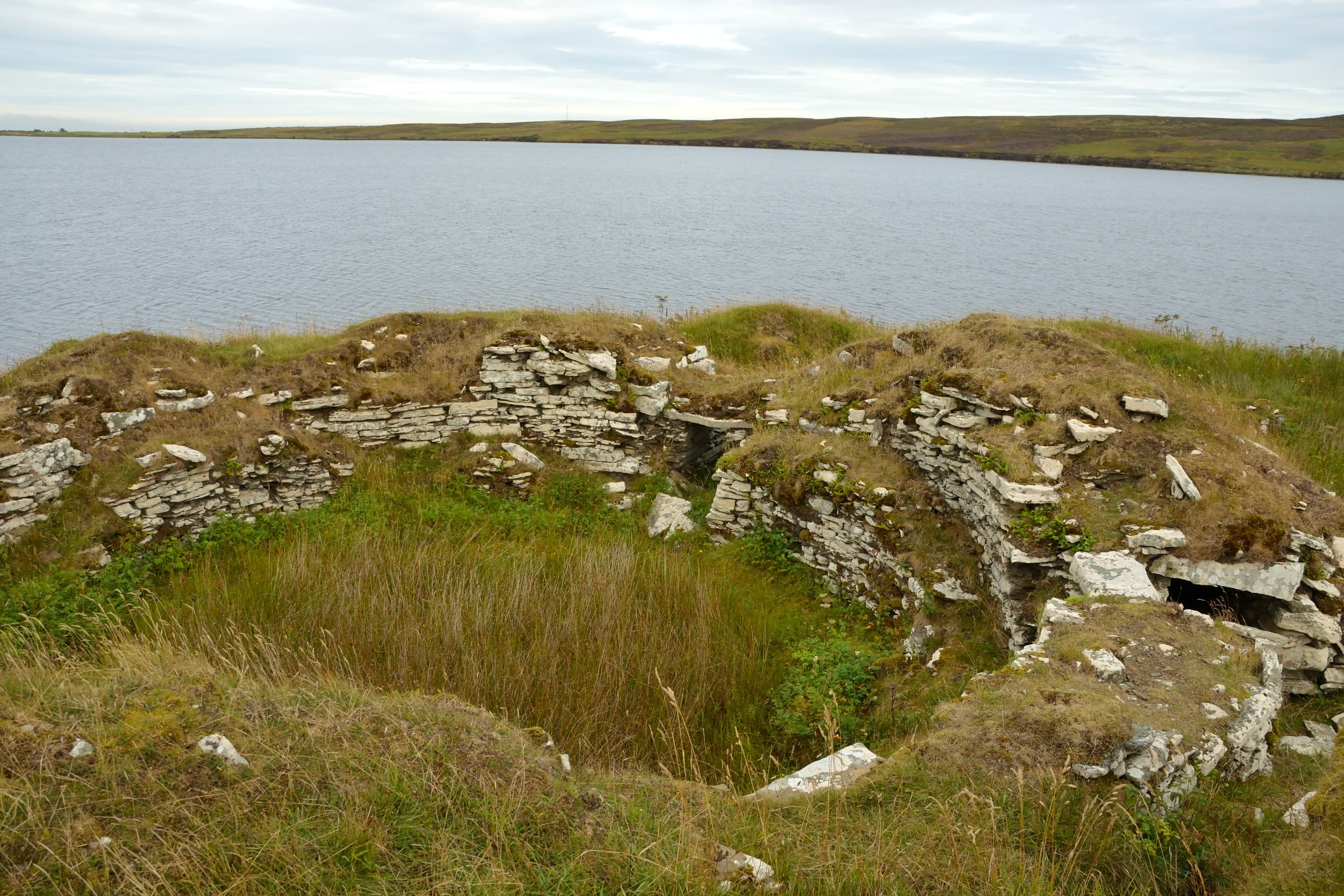
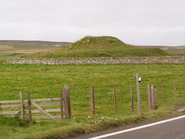
On a promontory jutting into the Loch of Yarrows, a broch stands at the centre of one of the richest archaeological landscapes in northern Scotland. Yarrows Broch is not just an Iron Age tower. It is the focal point of a palimpsest: Neolithic cairns on the surrounding ridges, Bronze Age hut circles in the fields, the broch itself, Pictish wag buildings constructed on its middens, and medieval burials placed within its ruined walls. Five thousand years of human activity converge at this point where land meets water. The broch's walls still rise nearly three metres, its entrance passage retains its original lintel, and the guard chamber beside the doorway remains intact.
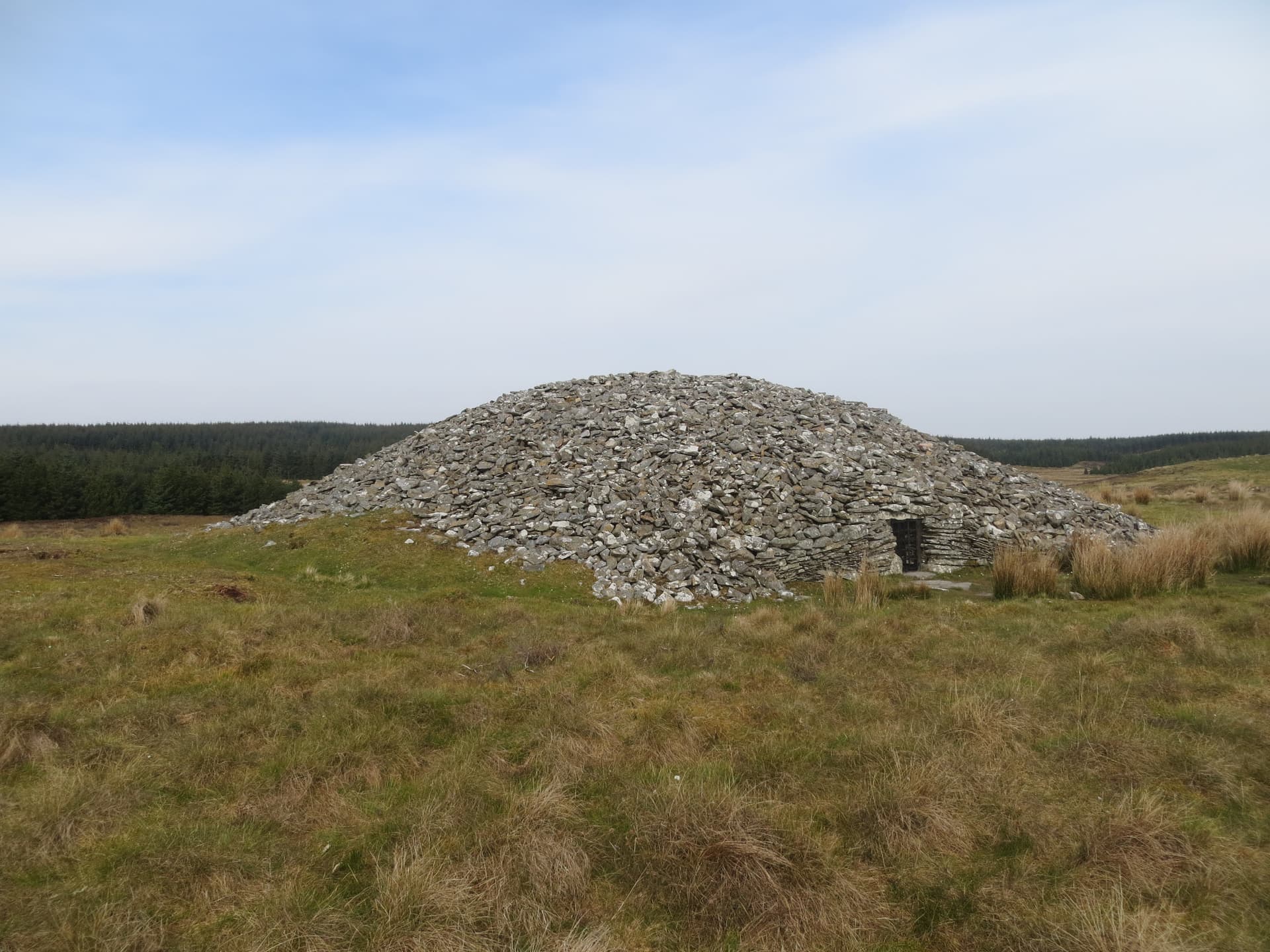
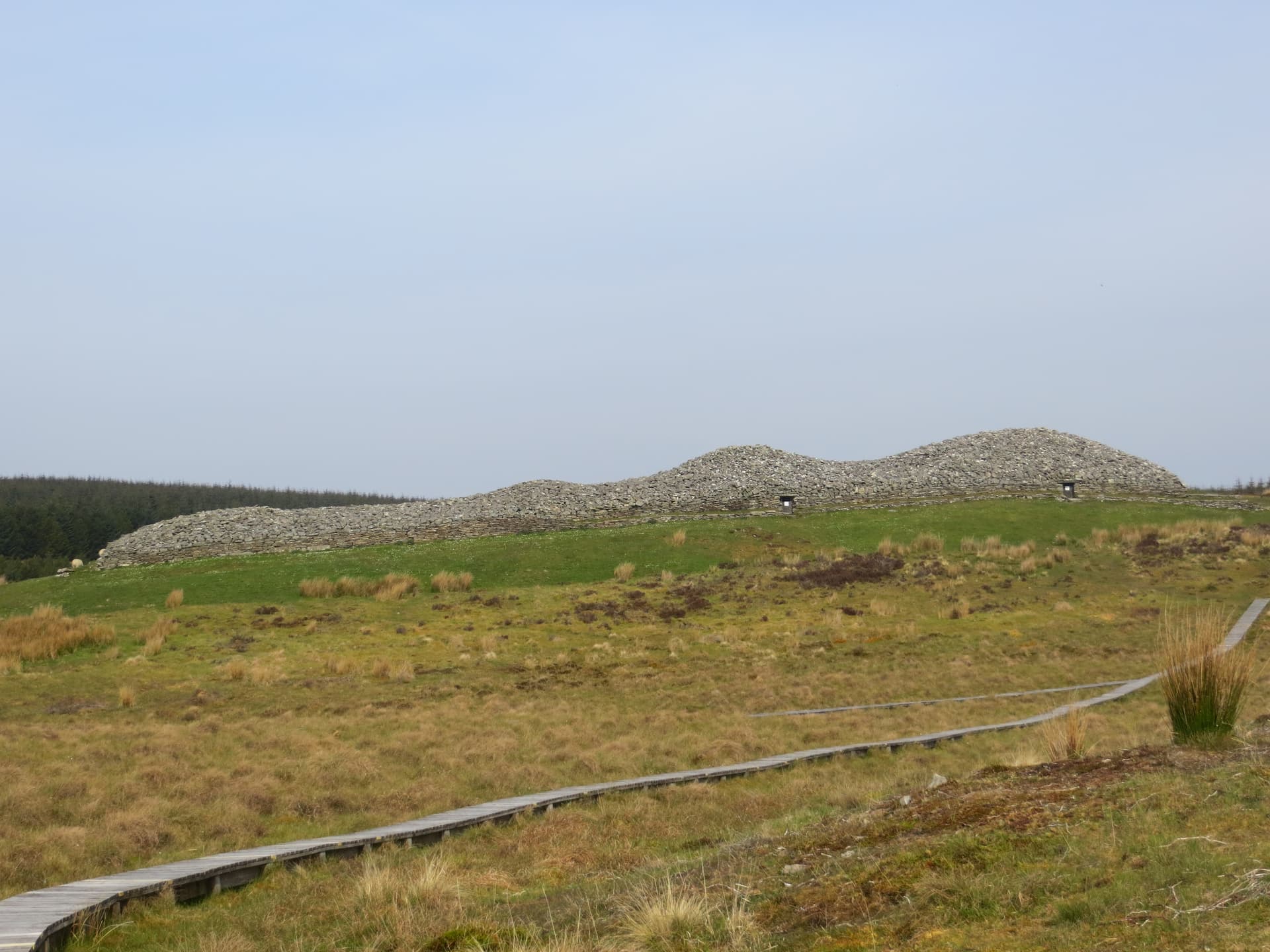
The walk to Yarrows Broch begins at a small parking area off the A99 at Thrumster and crosses open farmland through a landscape dense with monuments. Neolithic long cairns stand on the ridgeline above. A standing stone marks an unknown boundary. Bronze Age hut circles are visible as low rings in the grass. By the time you reach the loch shore and the broch itself, you have walked through millennia.
Yarrows Broch is described by the Caithness Broch Project as one of the most complex brochs in Caithness. Built on a promontory projecting into the loch, it occupies a position that is both naturally defensive and liminal, the boundary between land and water. The walls survive to nearly three metres in places. You can clearly see the passages and staircases built within the thickness of the walls, the double-wall construction that is the hallmark of broch architecture. The main entrance still has its door lintel in place. A small guard chamber opens to one side of the passage.
Surrounding the broch are the remains of later structures: aisled buildings known as wags, from the Gaelic word for cave, built by Pictish-era communities on top of the rubbish heaps of earlier inhabitants. This layering, each generation building literally on the remains of the last, gives Yarrows its particular density. And then there are the medieval dead. When Joseph Anderson excavated the broch in the 1860s, he found five human skeletons within the ruins, one buried with a brass brooch dating to the thirteenth century. A thousand years after the broch ceased to function as a dwelling, people were still choosing to place their dead within its walls.
Context and lineage
The Iron Age community who built the broch chose a promontory on the Loch of Yarrows already situated within an ancient landscape. Neolithic cairns visible on the surrounding ridges were already two thousand years old when the broch was raised. The builders constructed one of the most sophisticated brochs in Caithness, with architectural features including thin walls, a long intra-mural gallery, and internal cells that distinguish it from typical Caithness examples and suggest connections to Western Isles broch-building traditions.
The cultural lineage at Yarrows is broken but remarkably long. Neolithic farmers built cairns here around 3000 BCE. Bronze Age communities left hut circles. Iron Age builders raised the broch. Pictish settlers constructed wags. Medieval communities buried their dead among the ruins. No continuous tradition connects these successive cultures, yet each chose the same landscape for their most significant activities, suggesting enduring qualities in the place itself.
Joseph Anderson
Why this place is sacred
The layering at Yarrows is what distinguishes it from other brochs. A single-period site can be moving, but Yarrows offers something rarer: evidence that multiple, successive cultures all recognised this place as significant. The Neolithic farmers who built cairns on the surrounding ridges understood this landscape as important. The Iron Age community who raised the broch on the promontory chose a site already marked by earlier monuments. The Pictish builders who constructed wags among the broch's ruins were explicitly building on ancestral ground. And the medieval people who buried their dead within walls already two thousand years old were making a statement about continuity and belonging.
The promontory itself contributes to the site's character. The broch stands at the point where solid land gives way to water. In Celtic and pre-Celtic thought, boundaries between elements, land and water, earth and sky, were understood as places of power. Whether the Iron Age builders consciously chose this liminal position for its symbolic resonance cannot be proven, but the choice aligns with patterns observed at broch sites throughout Scotland.
The loch adds its own quality. Still water reflects the sky, creating a doubling effect that many visitors find contemplative. In calm conditions, the broch's reflection extends into the loch. The silence is notable: beyond the occasional bird call, there is little sound. Visitors consistently report the walk to the broch as a transition, a gradual leaving-behind of the modern world as the trail crosses farmland and enters the archaeological landscape.
Archaeological consensus identifies the broch as a high-status Iron Age dwelling, likely the residence of a local chieftain or elite family. The promontory location offered natural defence, while the monumental scale of construction signalled power and status. The thin-walled design and long intra-mural gallery show affinities with Western Isles brochs, suggesting cultural connections across Iron Age Scotland. The associated wag structures represent a later Pictish phase of settlement.
The site evolved through multiple phases: Iron Age broch construction, possible modification and repair, Pictish-era wag settlement, and medieval funerary use. Joseph Anderson's 1860s excavation was among the earliest systematic investigations of a Caithness broch. His discovery of five skeletons, including one with a thirteenth-century brass brooch, demonstrated that the site retained significance long after the broch's original function ended. The site came under statutory protection as Scheduled Monument 611 and is now part of the Yarrows Archaeological Trail.
Traditions and practice
Specific Iron Age rituals at Yarrows are unknown. The deposition of objects and the later burial of human remains within the broch may reflect ritualised acts of closure, dedication, or ancestor veneration. The medieval burials within the ruins suggest the site retained ceremonial significance. The wag builders' decision to construct on broch middens may indicate a desire to maintain physical connection with the ancestral site.
No established spiritual communities maintain practice at Yarrows Broch. The site is visited primarily by walkers, archaeology enthusiasts, and those exploring the Caithness landscape. The Yarrows Archaeological Trail provides interpretation panels along the route.
Walk the full trail circuit to experience the depth of the archaeological landscape. Take time at each monument along the route to let the chronological progression register. At the broch, explore the entrance passage and guard chamber. Observe the wag structures and consider the deliberate layering of cultures. The loch-side setting invites quiet contemplation.
Iron Age Broch Culture
HistoricalYarrows Broch represents the highest expression of Iron Age roundhouse architecture in Caithness. Its monumental construction on a loch-side promontory, with thin walls, intra-mural galleries, and a guarded entrance, indicates a high-status dwelling likely belonging to a local chieftain. The architectural connections to Western Isles traditions suggest cultural networks spanning Iron Age Scotland.
The broch community practised mixed agriculture, fishing from the loch, and animal husbandry. The monumental tower was both a dwelling and a symbol of status and power. Iron Age domestic life centred on the hearth, with evidence from comparable brochs suggesting metalworking, stone tool use, and food preparation.
Pictish Wag Settlement
HistoricalAfter the broch period, Pictish-era communities built aisled buildings known as wags on the accumulated middens surrounding the tower. This deliberate construction on ancestral ground demonstrates that the site retained significance across cultural transitions. The wags at Yarrows are comparable to the well-known Wag of Forse further south.
Wag communities practised Pictish-era agriculture and crafts. The construction of wags on earlier middens suggests intentional connection to ancestral presence and continuity of place-meaning.
Experience and perspectives
The Yarrows Archaeological Trail begins at a small parking area signposted from the A99 at Thrumster, roughly ten kilometres south of Wick. The trail crosses farmland on an informal path that can be boggy in wet weather. Allow for uneven ground and dress accordingly.
The walk is the preparation. You pass Neolithic long cairns, their chambered interiors still accessible in some cases. A standing stone marks an ancient boundary. Bronze Age hut circles appear as subtle rings in the moorland grass. By the time you reach the loch, you have already encountered three thousand years of human activity, and the broch's period has not yet begun.
The broch itself stands on a promontory extending into the loch, surrounded by the cellular buildings of the later Pictish settlement. The walls are impressive: nearly three metres high in places, the double-wall construction clearly visible. The entrance passage retains its original door lintel, and you can crouch through it as Iron Age inhabitants did. The guard chamber opens to one side, a small space where someone once waited to control access. Inside the tower, the layout of the interior is discernible despite the ruin. The intra-mural staircase, leading to upper floors now vanished, speaks of a building that was more than a single storey.
The surrounding wag structures, built on the accumulated middens of the broch settlement, have their own character: sunken floors with upright orthostats creating aisled interiors, a building form distinctive to Pictish Caithness. Standing in one of these wags, you are inside a structure built on the refuse of another culture, a layer cake of human occupation compressed into a few square metres.
The Yarrows Archaeological Trail forms a circular route linking the broch with Neolithic cairns and other monuments. The full circuit takes approximately ninety minutes to two hours. The broch is the trail's highlight and centrepiece. The site combines naturally with visits to Hill o' Many Stanes, the Grey Cairns of Camster, and other Caithness sites.
Yarrows Broch rewards multiple levels of engagement. As architecture, it is among the most sophisticated Iron Age structures in Caithness. As a multi-period site, it offers a compressed history of human settlement spanning five millennia. As a landscape experience, the walk through the archaeological trail creates a contemplative encounter with deep time.
Archaeologists classify Yarrows Broch as one of the most complex Iron Age roundhouses in Caithness. Anderson's 1860s excavation documented intra-mural cells, a staircase, and a guarded entrance consistent with high-status broch architecture. The thin walls and long gallery show Western Isles affinities rather than typical Caithness patterns, suggesting cultural connections across Iron Age Scotland. The surrounding wag structures represent a well-documented Pictish building tradition. The medieval burials demonstrate continued cultural significance. The broader Yarrows landscape is recognised as one of the richest sequences of prehistoric remains in Scotland.
No indigenous oral tradition survives from the Iron Age builders. The site's significance across multiple periods, with each successive culture choosing to inhabit or bury their dead at the same location, suggests enduring qualities that attracted communities across millennia, though the specific beliefs motivating each period of use are not recoverable.
The waterside positioning of the broch has been noted by some as potentially significant in relation to water veneration practices known in Celtic and pre-Celtic Scotland. The liminal position between land and water resonates with ideas about threshold spaces in various spiritual traditions. No specific esoteric tradition is documented for Yarrows.
Why the broch shows Western Isles rather than typical Caithness architectural features is unexplained. Submerged stonework in the loch adjacent to the broch has been recorded by divers but not fully investigated. Whether there was continuous occupation between the broch period and the construction of the wags, or a gap, is unresolved. Why medieval communities chose to bury their dead within ruins already over a thousand years old is not fully understood.
Visit planning
Signposted off the A99 at Thrumster, approximately ten kilometres south of Wick. Small parking area at OS grid reference ND306435. The trail crosses farmland on an informal path that can be very boggy. Not wheelchair accessible. No facilities at the site. Nearest town: Wick. Free access at all times. Very limited public transport; car access recommended. Nearest railway station: Wick.
Accommodation available in Wick, approximately ten kilometres north, including hotels, B&Bs, and self-catering options. Limited options closer to the site.
Yarrows Broch is a Scheduled Ancient Monument freely accessible as part of the Yarrows Archaeological Trail. Respect for the monument fabric and practical preparation for the walk across farmland are the main requirements.
Sturdy waterproof boots essential for the boggy terrain. Layered, windproof clothing advisable. No other specific requirements.
Photography permitted throughout. The loch-side setting provides excellent opportunities, particularly in morning and evening light.
Not applicable. Visitors should leave no trace at this archaeological site.
Do not damage the monument. Do not climb on walls. Close gates. Keep dogs under control due to livestock.
Plan your visit
Address
Wick KW1 5SE, UK
Hours
Hours, fees, and access can change — verify on the official source before you travel. Practical details last checked Jun 2026.
Nearby sacred places
Sacred places within a half-day’s reach. Pilgrims often visit them together: walk one, stay for the other.

References
Sources consulted when researching this page. Independent verification by readers is welcome.
- 01MHG1937 - Broch, Loch of Yarrows - Highland Historic Environment Record — Highland Councilhigh-reliability
- 02Yarrows Broch - Caithness Broch Project — The Broch Projecthigh-reliability
- 03Yarrows - Canmore/Trove Scotland — Historic Environment Scotlandhigh-reliability
- 04Yarrows Archaeological Trail - Historic Caithness Guide — Britain Express
- 05Yarrows Loch, Brochs and Archaeological Trail - Caithness, Scotland — Caithness and Sutherland Tourism
- 06Yarrows Archaeology Trail - WalkHighlands — WalkHighlands
- 07Three Brochs to Visit in Caithness - NorthLink Ferries — NorthLink Ferries
- 08At the Water's Edge: Top Archaeological Sites in Caithness - Dig It! — Dig It! Scotland
Key questions
What pilgrims usually ask
- Why is Yarrows Broch considered sacred?
- Visit Yarrows Broch in Caithness, one of Scotland's most complex Iron Age brochs. Walk the archaeological trail through 5,000 years of history beside the Loch o
- What should I wear at Yarrows Broch?
- Sturdy waterproof boots essential for the boggy terrain. Layered, windproof clothing advisable. No other specific requirements.
- Can I take photos at Yarrows Broch?
- Photography permitted throughout. The loch-side setting provides excellent opportunities, particularly in morning and evening light.
- How long should I spend at Yarrows Broch?
- Two to three hours for the full archaeological trail circuit, including time at the broch and other monuments.
- How do you visit Yarrows Broch?
- Signposted off the A99 at Thrumster, approximately ten kilometres south of Wick. Small parking area at OS grid reference ND306435. The trail crosses farmland on an informal path that can be very boggy. Not wheelchair accessible. No facilities at the site. Nearest town: Wick. Free access at all times. Very limited public transport; car access recommended. Nearest railway station: Wick.
- What offerings are appropriate at Yarrows Broch?
- Not applicable. Visitors should leave no trace at this archaeological site.
- What etiquette should visitors follow at Yarrows Broch?
- Yarrows Broch is a Scheduled Ancient Monument freely accessible as part of the Yarrows Archaeological Trail. Respect for the monument fabric and practical preparation for the walk across farmland are the main requirements.
- What is the history of Yarrows Broch?
- The Iron Age community who built the broch chose a promontory on the Loch of Yarrows already situated within an ancient landscape. Neolithic cairns visible on the surrounding ridges were already two thousand years old when the broch was raised. The builders constructed one of the most sophisticated brochs in Caithness, with architectural features including thin walls, a long intra-mural gallery, and internal cells that distinguish it from typical Caithness examples and suggest connections to Western Isles broch-building traditions.