Xerez Cromlech
A Neolithic monument dismantled stone by stone and rebuilt to outrun a reservoir
Reguengos de Monsaraz, Monsaraz, Reguengos de Monsaraz, Évora / Alentejo, Portugal
Plan this visit
Practical context before you go
30 to 45 minutes for a guided visit.
Located near the Orada Convent in the village of Telheiro, parish of Monsaraz, municipality of Reguengos de Monsaraz. Easy parking is available on site. The site is reachable by car; no public transport serves it directly. Contact the Câmara Municipal de Reguengos de Monsaraz at +351 266 508 052 or turismo@cm-reguengos-monsaraz.pt to arrange a guided visit.
Xerez is visited by guided access only, arranged through the Reguengos de Monsaraz municipal tourism office; there is no fixed public opening schedule and no dress code, but visitors should follow their guide's directions closely given the monument's recent relocation.
At a glance
- Coordinates
- 38.4534, -7.3710
- Type
- Archaeological Site
- Suggested duration
- 30 to 45 minutes for a guided visit.
- Access
- Located near the Orada Convent in the village of Telheiro, parish of Monsaraz, municipality of Reguengos de Monsaraz. Easy parking is available on site. The site is reachable by car; no public transport serves it directly. Contact the Câmara Municipal de Reguengos de Monsaraz at +351 266 508 052 or turismo@cm-reguengos-monsaraz.pt to arrange a guided visit.
Pilgrim tips
- No dress requirements; comfortable footwear is recommended for the guided walk around the site.
- Personal photography is generally permitted; confirm specifics with your guide on arrival, since guided-access sites sometimes have visit-specific requests that aren't documented publicly in advance.
- Do not touch or attempt to climb the reassembled stones, which were carefully repositioned during the 2001–2004 relocation and remain more vulnerable to disturbance than a monument that has stood undisturbed in place for millennia. Follow your guide's directions throughout the visit.
Overview
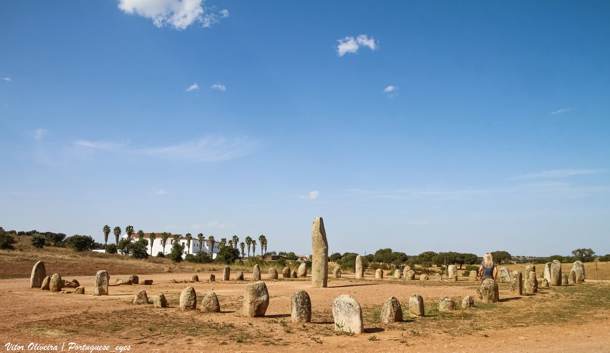
Fifty-five granite menhirs encircle a central stone nearly 4.5 meters tall in a rare square rather than circular plan, near the village of Telheiro in the Alqueva region. Facing submersion by a new dam reservoir, the entire monument was taken apart in 2001 and physically reassembled on higher ground, with reconstruction deliberately completed on the summer solstice of 2004.
Xerez holds a distinction no other Alqueva-area megalith shares: it is the one monument that reservoir waters never claimed, because in November 2001 it was dismantled, stone by numbered stone, and carried to higher ground near the Orada Convent.
What was moved is unusual in its own right. Fifty-five granite menhirs, ranging from under half a meter to over two meters tall, surround a central standing stone roughly 4.5 meters high and weighing some seven tonnes — a form some interpretive sources describe as phallic, its surface carved with shallow dimpled depressions. The stones are arranged in a square rather than the circular plan more familiar from Alentejo megalithism, a layout whose authenticity is itself a subject of open scholarly dispute.
Construction began in the early-to-middle Neolithic, around 4000 BCE, with a further redesign phase later in the Neolithic. The site was identified in 1969 when agricultural stone-clearing exposed the central menhir; archaeologist Mário Varela Gomes led a 1998 excavation that filled in much of what is known about the site's occupation sequence, including hints of even earlier Late Paleolithic activity in the surrounding landscape.
The rescue itself has become part of what Xerez means today — a prehistoric ceremonial site and, layered onto it, a very modern story of a community that decided not to let the water win.
Context and lineage
No founding narrative survives from the community that raised these fifty-five stones and the central menhir around them; what is known comes from excavation and comparison with related Alentejo sites. Construction began in the early-to-middle Neolithic, roughly the fifth to fourth millennium BCE, with a later redesign phase in the late Neolithic, and the 1998 excavation identified evidence suggesting even earlier Late Paleolithic activity in the surrounding landscape.
The site's modern history begins in 1969, when a farmer's field, cleared of surface stones for agriculture, revealed the buried central menhir. José Pires Gonçalves identified the find and proposed the quadrilateral layout that gives Xerez its unusual profile among Iberian cromlechs. Decades later, the rise of the Alqueva Dam reservoir threatened to submerge the site along with much of the surrounding valley. In November 2001, rather than let the water take it, the monument was dismantled stone by stone and carried to higher ground near the Orada Convent — a rescue completed with reconstruction finished on 24–25 June 2004, deliberately timed to the summer solstice.
No continuous ritual community connects the Neolithic builders of Xerez to the present. What exists instead is a lineage of rescue and stewardship: the 1969 identification, the 1998 excavation, and above all the 2001–2004 dismantling and physical relocation that saved the monument from the Alqueva reservoir. That rescue is now part of the site's institutional memory, maintained through the regional Paisagem Ancestral megalithic heritage route and the municipal tourism office that arranges guided access today.
José Pires Gonçalves
excavator
Identified the Xerez site in 1969 after agricultural land-clearing exposed the central menhir, and proposed the quadrilateral cromlech layout that distinguishes the monument.
Mário Varela Gomes
excavator
Archaeologist at the Universidade Nova de Lisboa who led the 1998 excavation identifying lithic and ceramic artefacts and the site's multi-period occupation sequence.
Why this place is sacred
Regional heritage authorities interpret Xerez as a ceremonial space for cyclical rituals tied to agricultural fertility and solar regeneration, its stones marking the solstices and equinoxes as moments of symbolic renewal. The central menhir — nearly 4.5 meters tall, weighing roughly seven tonnes, and carved with shallow depressions some describe in phallic terms — anchors this reading, though no confirmed astronomical alignment has been established through direct evidence for any specific solstice or equinox sightline at the site; the solar-fertility interpretation rests on the symbolism of the central stone and comparison with similar Alentejo monuments rather than on a documented alignment.
Seven of the surrounding fifty-five menhirs carry engraved decorative motifs comparable to those found at the Almendres Cromlech roughly forty kilometers away, suggesting Xerez's builders shared a symbolic vocabulary with other Neolithic communities of the wider region even while building in an unusual square configuration.
That square plan is itself disputed. Some sources treat it as a genuine ancient design; others note that archaeologist José Pires Gonçalves's 1969 identification, and the subsequent 1972 and 2001–2004 re-erections, may have introduced or reinforced a layout that isn't necessarily how the Neolithic builders originally arranged the stones. Both readings are held here without resolution, since the surviving record does not settle the question either way.
What is not in dispute is the modern rescue. In November 2001, facing the certain flooding of the Alqueva Dam reservoir, the entire monument was dismantled and moved a short distance to higher ground near the Orada Convent — the only megalith in the flooded area saved this way rather than left to be submerged. Reconstruction was completed deliberately on 24–25 June 2004, timed to the summer solstice: a modern ceremonial gesture layered onto an ancient one, even if the ancient alignment it echoes cannot itself be confirmed.
Regional heritage authorities and archaeologists read Xerez as a ceremonial site for cyclical rituals tied to the agricultural calendar and solar regeneration, based on the central menhir's form and the broader pattern of Alentejo megalithism, but this remains an interpretation rather than a documented certainty — no oral or written tradition survives from the site's Neolithic builders to confirm it.
Xerez was identified in 1969 by José Pires Gonçalves after agricultural de-stoning exposed the central menhir; Gonçalves also proposed the site's distinctive quadrilateral layout. A 1998 excavation led by Mário Varela Gomes of the Universidade Nova de Lisboa uncovered lithic and ceramic artefacts and identified a multi-period occupation sequence, including possible earlier Late Paleolithic activity. The site was declared a Property of Public Interest in Portugal in 1986. Its defining modern event came in November 2001, when the entire complex was dismantled to escape flooding from the new Alqueva Dam reservoir and relocated a short distance to higher ground near the Orada Convent, with reconstruction completed on the summer solstice of 2004. Today Xerez functions as a guided heritage attraction within the regional Paisagem Ancestral megalithic route, quieter and less visited than the better-known Almendres or Zambujeiro sites.
Traditions and practice
Regional heritage authorities interpret likely prehistoric practice at Xerez as cyclical fertility and solar-regeneration ceremonies aligned with the solstices and equinoxes, centered on the large central menhir's form. This remains an interpretation drawn from comparison with related Alentejo sites and the symbolism of the stone itself, rather than a documented ritual sequence — no confirmed astronomical alignment or written account survives to specify what was said or performed here.
No organized ceremonial practice occurs at Xerez today; visits are arranged as guided heritage tours through the Reguengos de Monsaraz municipal tourism office. The one deliberate ceremonial gesture in the site's recent history was itself modern: the 2001–2004 reconstruction was timed to conclude on the summer solstice, 24–25 June 2004, a symbolic act of completion rather than an ongoing ritual practice.
Stand before the central menhir and take in its scale before turning to the surrounding fifty-five stones — the sequence matters, since the smaller stones read differently once you have registered what they encircle. Ask your guide to point out the seven menhirs bearing decorative engravings and consider their resemblance to motifs found at Almendres, a monument built by a different community roughly forty kilometers away. Before leaving, take a moment with the knowledge that these particular stones would not be standing here at all without a deliberate act of rescue — dismantled, carried, and rebuilt by people determined not to let a reservoir erase them.
Neolithic/Chalcolithic Solar-Cycle Fertility Cult
HistoricalBuilt beginning around 4000 BCE with a later Neolithic redesign phase, Xerez is interpreted by regional heritage authorities as a ceremonial space for cyclical rituals tied to agricultural fertility and solar regeneration, its central 4.5-meter, seven-tonne phallic-form menhir surrounded by 55 smaller stones forming a distinctive square variant on the stone-circle tradition.
Presumed cyclical or seasonal ceremonies tied to the solar calendar, and fertility or regeneration rites suggested by the central menhir's form — inferred from the stone's symbolism and comparison with related Alentejo sites rather than documented directly.
Archaeological Heritage and Rescue Stewardship
ActiveXerez holds a unique place in Portuguese heritage history as the only megalithic monument physically dismantled and relocated, in November 2001, to escape flooding by the Alqueva Dam reservoir, then reconstructed near the Orada Convent with completion deliberately timed to the summer solstice of 24–25 June 2004.
Rescue archaeology, stone-by-stone dismantling and reassembly, ongoing conservation, and public interpretation via the regional Paisagem Ancestral megalithic route.
Experience and perspectives
Because Xerez requires a guided visit arranged through the municipal tourism office rather than casual drop-in access, the experience of arriving here is more deliberate than at Almendres or Zambujeiro. Visitors describe this as part of the site's appeal — a quieter, more considered encounter, often shared with a small group and a guide rather than navigated alone.
Visitors often express curiosity about the site's unusual square arrangement, which departs so visibly from the circular or elliptical plans found elsewhere in the region. The central menhir draws the most attention: nearly 4.5 meters tall, its form and carved depressions prompting the kind of direct, sometimes startled reaction that abstract stone circles rarely produce.
Guides at Xerez tend to foreground the 2001 rescue and 2004 reconstruction as central to the visit, not as an aside. Encountering a megalithic monument that was itself deliberately saved through sustained human effort — dismantled, catalogued, carried, and rebuilt — adds a layer of narrative resonance visitors describe as uncommon among prehistoric sites, where the story usually ends with discovery rather than a second act of rescue.
Arrange your visit through the Reguengos de Monsaraz tourism office in advance, since no fixed public opening hours are documented and access is guided. Once there, take time with the central menhir before moving to the surrounding ring — its scale and carved surface reward a slower look than the smaller stones around it. Ask your guide about the square plan's disputed authenticity; it is one of the more genuinely open questions in Alentejo megalithism, and hearing both readings held side by side is part of what makes a guided visit here worthwhile rather than merely convenient.
Xerez asks a visitor to hold two kinds of uncertainty at once: a genuine scholarly dispute over whether its square layout is ancient or a product of modern interpretation, and the simpler, better-documented story of a community's deliberate choice to save the monument from flooding rather than let it disappear.
Archaeologists broadly agree the site had ceremonial and likely solar or fertility ritual functions during the Neolithic and Chalcolithic, based on the central menhir's form and comparison with related regional monuments. Where scholarship is explicitly divided is over the square, rather than circular, plan: some treat it as an authentic ancient design, while others argue it may reflect subjective interpretive choices made during the 1969 identification and the subsequent 1972 and 2001–2004 re-erections. The total number of stones also varies across sources, cited as 50, 55, or 56 depending on the count used; this account uses 55 surrounding stones plus the central menhir, drawn from the most detailed excavation-based figure available.
No continuous indigenous or traditional custodial community exists at Xerez; Portuguese national and municipal heritage bodies serve as stewards, and the site is now integrated into the regional Paisagem Ancestral megalithic heritage route, which frames it within a broader narrative of solar-cycle ritual and landscape continuity across the Alqueva area.
Some heritage-tourism writers frame the central phallic-form menhir and the site's solar orientation within a broader earth-fertility or goddess-and-god symbolic framework common to Alentejo megalithism. These readings extend, but do not directly contradict, the archaeological fertility-cult interpretation — they simply carry the symbolism further than the excavated evidence alone supports.
Whether the quadrilateral layout is an authentic prehistoric design remains genuinely disputed, not settled by the available record. The full extent of the Late Paleolithic activity suggested by the 1998 excavation, and the precise nature of any ceremonies once conducted around the central menhir, remain open questions given the site's fragmentary record and its unusual history of relocation.
Visit planning
Located near the Orada Convent in the village of Telheiro, parish of Monsaraz, municipality of Reguengos de Monsaraz. Easy parking is available on site. The site is reachable by car; no public transport serves it directly. Contact the Câmara Municipal de Reguengos de Monsaraz at +351 266 508 052 or turismo@cm-reguengos-monsaraz.pt to arrange a guided visit.
No lodging exists at the site itself. Reguengos de Monsaraz and the nearby walled village of Monsaraz offer accommodation options, and the wider Alqueva region has developed a growing base of rural guesthouses tied to its reservoir-era tourism.
Xerez is visited by guided access only, arranged through the Reguengos de Monsaraz municipal tourism office; there is no fixed public opening schedule and no dress code, but visitors should follow their guide's directions closely given the monument's recent relocation.
No dress requirements; comfortable footwear is recommended for the guided walk around the site.
Personal photography is generally permitted; confirm specifics with your guide on arrival, since guided-access sites sometimes have visit-specific requests that aren't documented publicly in advance.
There is no tradition of offerings at this relocated archaeological site, and none should be left at the stones.
Access is guided only; visitors should follow the accompanying guide's directions throughout and avoid touching or climbing the reassembled stones.
Nearby sacred places
Sacred places within a half-day’s reach. Pilgrims often visit them together: walk one, stay for the other.

Sanctuary of Our Lady of the Conception of Vila Viçosa
Vila Viçosa, Vila Viçosa, Évora / Alentejo, Portugal
36.7 km away

Évora Cathedral
Évora, Évora, Évora / Alentejo, Portugal
48.4 km away

Evora, Roman Temple
Évora, Évora, Portugal
48.5 km away

Great Dolmen of Zambujeiro
Évora, Valverde, Évora, Évora / Alentejo, Portugal
56.8 km away
References
Sources consulted when researching this page. Independent verification by readers is welcome.
- 01Cromeleque do Xarez/Xerez — Portal do Arqueólogo, Direção-Geral do Património Cultural — Direção-Geral do Património Cultural (Portugal)high-reliability
- 02Cromeleque do Xerez — Câmara Municipal de Reguengos de Monsaraz — Câmara Municipal de Reguengos de Monsarazhigh-reliability
- 03Megalithic Route – Cromeleque do Xarez — Paisagem Ancestral — Paisagem Ancestral (regional megalithic heritage route)high-reliability
- 04Xerez Cromlech — Wikipedia — Wikipedia contributors
- 05Cromeleque do Xarez Stone Circle — The Megalithic Portal — The Megalithic Portal
- 06Xerez Cromlech — Roteiro do Alqueva — Roteiro do Alqueva (Alqueva regional tourism guide)
- 07Cromeleque do Xerez — All About Portugal — All About Portugal
Key questions
What pilgrims usually ask
- Why is Xerez Cromlech considered sacred?
- Trace Xerez Cromlech, a Neolithic stone circle dismantled and rebuilt to escape the Alqueva reservoir, its reconstruction completed on the summer solstice.
- What should I wear at Xerez Cromlech?
- No dress requirements; comfortable footwear is recommended for the guided walk around the site.
- Can I take photos at Xerez Cromlech?
- Personal photography is generally permitted; confirm specifics with your guide on arrival, since guided-access sites sometimes have visit-specific requests that aren't documented publicly in advance.
- How long should I spend at Xerez Cromlech?
- 30 to 45 minutes for a guided visit.
- How do you visit Xerez Cromlech?
- Located near the Orada Convent in the village of Telheiro, parish of Monsaraz, municipality of Reguengos de Monsaraz. Easy parking is available on site. The site is reachable by car; no public transport serves it directly. Contact the Câmara Municipal de Reguengos de Monsaraz at +351 266 508 052 or turismo@cm-reguengos-monsaraz.pt to arrange a guided visit.
- What offerings are appropriate at Xerez Cromlech?
- There is no tradition of offerings at this relocated archaeological site, and none should be left at the stones.
- What etiquette should visitors follow at Xerez Cromlech?
- Xerez is visited by guided access only, arranged through the Reguengos de Monsaraz municipal tourism office; there is no fixed public opening schedule and no dress code, but visitors should follow their guide's directions closely given the monument's recent relocation.
- What is the history of Xerez Cromlech?
- No founding narrative survives from the community that raised these fifty-five stones and the central menhir around them; what is known comes from excavation and comparison with related Alentejo sites. Construction began in the early-to-middle Neolithic, roughly the fifth to fourth millennium BCE, with a later redesign phase in the late Neolithic, and the 1998 excavation identified evidence suggesting even earlier Late Paleolithic activity in the surrounding landscape. The site's modern history begins in 1969, when a farmer's field, cleared of surface stones for agriculture, revealed the buried central menhir. José Pires Gonçalves identified the find and proposed the quadrilateral layout that gives Xerez its unusual profile among Iberian cromlechs. Decades later, the rise of the Alqueva Dam reservoir threatened to submerge the site along with much of the surrounding valley. In November 2001, rather than let the water take it, the monument was dismantled stone by stone and carried to higher ground near the Orada Convent — a rescue completed with reconstruction finished on 24–25 June 2004, deliberately timed to the summer solstice.