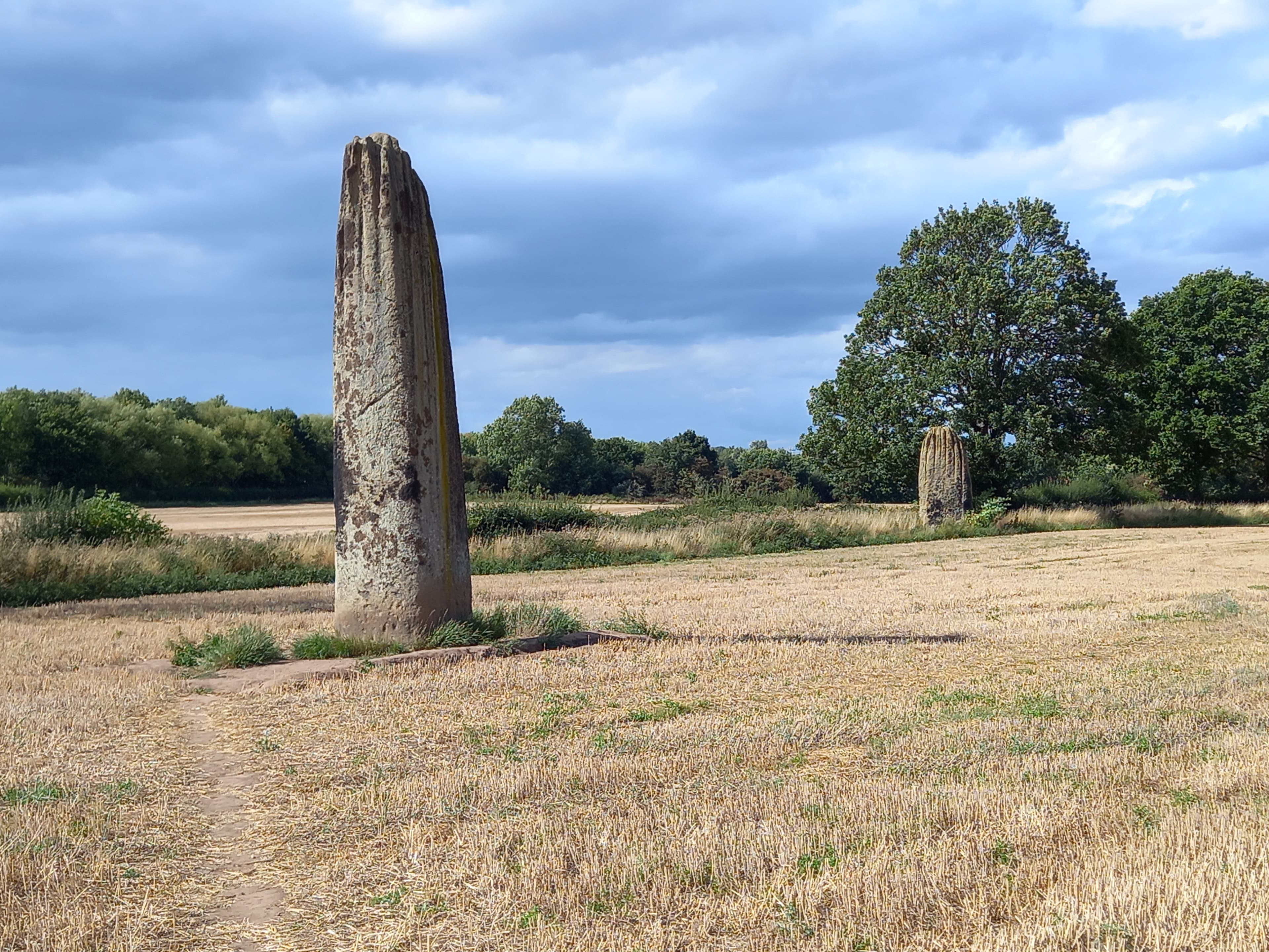
The Devils Arrows
Three ancient giants standing where the Devil's arrows fell short
Boroughbridge, England, United Kingdom
Plan this visit
Practical context before you go
A basic visit—parking, walking to all three stones, returning—takes thirty minutes to an hour. Those wishing to sit with the stones, walk the alignment multiple times, or meditate will want longer. Combined with the Thornborough Henges, the area merits a half-day exploration.
The Devil's Arrows require the respect due to both a protected ancient monument and a working agricultural landscape. No active religious practice takes place, so etiquette centers on preservation and respect for the landowner rather than sacred protocol.
At a glance
- Coordinates
- 54.0917, -1.4167
- Type
- Standing Stones
- Suggested duration
- A basic visit—parking, walking to all three stones, returning—takes thirty minutes to an hour. Those wishing to sit with the stones, walk the alignment multiple times, or meditate will want longer. Combined with the Thornborough Henges, the area merits a half-day exploration.
Pilgrim tips
- There are no dress requirements. Wear practical clothing suitable for walking across potentially muddy farmland. Sturdy footwear is advisable, particularly after rain.
- Photography is welcome and unrestricted. No permits are required for personal use. The stones photograph well at dawn and dusk when low light emphasizes their texture. Consider whether every photograph is necessary, and whether presence might sometimes matter more than documentation.
- The site has no formal restrictions beyond those applying to any Scheduled Ancient Monument: do not damage, excavate, or alter the stones in any way. Leaving offerings—candles, crystals, flowers—may feel spiritually appropriate but creates litter on agricultural land and is discouraged. Two of the three stones stand on private farmland. Access is permitted but visitors should respect the working agricultural environment, close gates behind them, and avoid disturbing livestock. The farmer's tolerance of visitors depends on visitors' respect for the land.
Overview
Rising from the fields west of Boroughbridge, the Devil's Arrows are among Britain's tallest and most mysterious standing stones. Erected some four thousand years ago and transported nine miles from their quarry, these weathered monoliths mark what scholars believe was once a ceremonial landscape rivaling Stonehenge in significance. The rituals that brought them here have fallen silent, but their presence—grooved by millennia of rain, rooted in soil that has witnessed epochs—continues to arrest those who encounter them.
They stand where no stones should be. Three monoliths of millstone grit, their surfaces carved by four thousand years of Yorkshire weather into deep vertical grooves, rising from farmland that gives no hint of what lies beneath the plough. The tallest reaches nearly seven meters—higher than any standing stone in Britain save the Rudston Monolith forty miles east.
The effort required to bring them here defies casual explanation. Nine miles they travelled from Plumpton Rocks, each stone weighing perhaps thirty tonnes, dragged by people whose names we will never know for purposes we can only guess. When William Camden described them in 1586, he called them the greatest wonder he had seen on all his travels through Britain.
The name came later—a Christian reframing of older power. The Devil, so the story goes, hurled these arrows at Aldborough to destroy the town, crying 'Borobrigg keep out o' way!' But his aim was poor, his bolts falling short where they stand today. It is a common pattern: what cannot be explained through familiar categories becomes the Devil's work. What the stones actually witnessed—what ceremonies, what gatherings, what understanding of cosmos and community—remains hidden beneath the folklore.
They ask nothing of visitors. They offer no interpretation boards, no gift shop, no audio guide. One stands at the roadside, alone behind a low fence. Two others wait in a farmer's field, visible but requiring a walk across grass that may be wet, that may hold livestock, that asks you to step off the path and into the landscape itself.
Context and lineage
No founding narrative survives from the people who erected the stones. What remains is the folklore that followed: the Devil, standing on Howe Hill, attempted to destroy the Christian town of Aldborough by hurling massive stone arrows. His cry echoed across the land—'Borobrigg keep out o' way, for Aldborough town I will ding down!' But his aim proved poor. The arrows fell short, landing in the fields west of Boroughbridge where they stand today.
This is, of course, a later invention—a way of explaining what could not otherwise be understood. The pattern is common across Britain: stones of mysterious origin become the Devil's handiwork, sacred sites of pre-Christian practice reframed as evidence of Satan's malevolence and failure. The story tells us more about medieval Christian anxiety than about Bronze Age intention.
Another variant suggests the stones simply 'sprung up one night in the very places they now occupy'—magical emergence rather than human effort. Both stories point toward the same recognition: that something about these stones exceeds ordinary explanation.
The stones stood here before recorded history, before the Romans came to nearby Aldborough, before the English language existed. For two thousand years, perhaps longer, they witnessed ceremonies whose nature we can only imagine—gatherings aligned with solstices, offerings to powers we no longer name.
The Romans must have known them, their settlement at Isurium Brigantum lying less than two miles east. What they made of the stones goes unrecorded. Medieval farmers worked the land around them, eventually forgetting whatever meaning had once attached, until the stones became the Devil's work—an explanation for the inexplicable.
By the 18th century, antiquarians were documenting what they found, preserving traditions that might otherwise have vanished. The St. Barnabas Fair, held near the stones on Midsummer's Day until sometime in the 18th century, may have represented continuity from Bronze Age solstice gatherings—or may have been a medieval invention. The link remains suggestive but unproven.
Since 1923, the stones have held legal protection as a Scheduled Ancient Monument. They are managed by Historic England, though 'managed' may be too strong a word—they stand as they have always stood, largely uninterpreted, asking visitors to bring their own meaning.
William Camden
historical
The Elizabethan antiquary who described the stones in his 1586 Britannia, calling them the greatest wonder he had seen in Britain. He recorded four stones standing in his time, with one already toppled by treasure hunters.
John Aubrey
historical
The 17th-century antiquary who visited in 1687 and recorded the name 'Devil's Arrows' in his notes—the first documented use of this title.
William Stukeley
historical
The 18th-century antiquary who documented the site and recorded the St. Barnabas Solstice Fair tradition. He theorized that the stones served as 'Metae of the Races'—turning points for ceremonial races—and connected the site to his romantic vision of Druidic practice.
Alfred Watkins
historical
The early 20th-century antiquarian who identified the Devil's Arrows as lying on a ley line—a straight alignment of ancient sites that he believed represented prehistoric trackways.
Why this place is sacred
The stones did not arrive here by accident. They stand within what archaeologists call the Ure-Swale ritual landscape—a concentration of prehistoric monuments stretching across the Yorkshire lowlands that represents one of northern Britain's most significant ceremonial complexes. The Thornborough Henges, six miles north and sometimes called 'the Stonehenge of the North,' form the most dramatic expression of this sacred geography, but the landscape holds much more: henges at Hutton Moor and Nunwick, barrows scattered across the plateau, timber post rows revealed through aerial survey.
The Devil's Arrows appear to function as markers within this larger whole. Their alignment runs roughly north-northwest to south-southeast, possibly oriented toward the southernmost summer moonrise—a celestial event that would have held significance for people attuned to astronomical cycles. Alfred Watkins, who developed the controversial ley line theory, identified the stones as falling on such an alignment. Whether or not one accepts his interpretation, the positioning was clearly intentional.
What made this particular landscape sacred to its Bronze Age inhabitants remains a matter of informed speculation. The area sits at a natural crossroads where rivers meet, where routes of travel converge. Perhaps the stones marked territorial boundaries, or served as gathering points for scattered communities, or created a processional path connecting one monument to another. Perhaps they did all of these, and more besides.
The grooves that pattern their surfaces look almost intentional—so deliberately carved that some have interpreted them as phallic symbolism. Geologists explain them as natural weathering of the millstone grit, but four thousand years of rain and wind have given them a texture that invites touch, that makes the stones feel worked by time itself. Whatever ceremonies once occurred here left no written record, but the stones persist—witnesses to something we can sense but not name.
Archaeological evidence suggests the stones formed part of a Late Neolithic or Early Bronze Age ritual complex, erected somewhere between 2700 and 2000 BCE. Their relationship to the Thornborough Henges and other nearby monuments indicates they were not isolated features but elements within a larger sacred geography. The scale of effort required—transporting thirty-tonne stones nine miles from Plumpton Rocks—demonstrates that the site held profound significance to its builders. Whether they served as processional markers, astronomical alignments, territorial boundaries, or something beyond modern categories of understanding, the intention behind their placement was clearly ceremonial.
Originally four or perhaps five stones stood here. By 1584, when German traveler Lupold Von Wedel visited, only four remained upright with one fallen. Within decades, one was broken up for bridge construction over the River Tutt—practical recycling of what must have seemed, to its destroyers, merely inconvenient rock. The remaining three survived partly through obscurity, partly through their sheer mass.
The name 'Devil's Arrows' first appears in John Aubrey's notes from 1687, reflecting the Christian tendency to attribute unexplainable monuments to Satan rather than acknowledge pre-Christian sacred practice. By the 18th century, antiquarians like William Stukeley were documenting the site and recording local traditions, including the St. Barnabas Solstice Fair that had been held near the stones for generations—perhaps a thread connecting backward to whatever midsummer gatherings the Bronze Age builders knew.
Today the stones stand in agricultural land, unexcavated in modern times, their surroundings never systematically explored. Field surveys have revealed tantalizing hints—flint scatters, grooved ware pottery, traces of timber structures—but the full story of this place remains beneath the soil.
Traditions and practice
Whatever rituals the Bronze Age builders performed here have left no written record. The stones' alignment with the Thornborough Henges and possible astronomical orientation suggest ceremonies timed to celestial events—perhaps summer solstice gatherings, perhaps observations of the moon's extreme rising points. The presence of flint scatters and grooved ware pottery in the surrounding area indicates sustained human activity, though its exact nature remains speculative.
The best-documented historical practice is the St. Barnabas Solstice Fair, recorded by William Stukeley in the 18th century. Held near the stones on June 24 (originally the summer solstice before calendar reform), this annual gathering may have preserved some thread of continuity from prehistoric celebration—or may have been a medieval appropriation of a striking location. Stukeley believed the stones served as 'Metae of the Races,' turning points for ceremonial races that formed part of the fair. By the time he documented it, the tradition was fading; it appears to have ceased entirely by century's end.
The Devil's Arrows attract visitors from earth mysteries and modern pagan traditions who engage the site through personal spiritual practice. No organized ceremonies take place—the site lacks the infrastructure and community that would support them—but individuals report meditating at the stones, dowsing for ley lines, or simply sitting in contemplation of their age and mystery.
The stones' inclusion in ley line literature, particularly Alfred Watkins' work and Paul Devereux's subsequent studies, has drawn practitioners interested in landscape energy and sacred geometry. Whether or not one accepts these interpretive frameworks, they have shaped how many contemporary visitors approach the site.
If you seek engagement beyond photography, consider these possibilities:
Walk the alignment. Beginning at the southernmost stone on Roecliffe Lane, cross to the field where the central and northern stones stand, then walk between them. Notice the spacing, the sightlines, the way the landscape opens or closes as you move. The builders placed these stones with intention; walking their arrangement is one way of reading it.
Sit with silence. Choose one stone and remain with it for ten or fifteen minutes. Notice the texture of the surface, the way light falls across the grooves, the sounds of the surrounding landscape. Allow yourself to not know what the stone means.
Visit at significant times. The summer solstice, around June 21, echoes whatever ceremonies may once have occurred here. Early morning or evening light reveals the stones differently than midday glare. The site receives few visitors at any time; dawn or dusk may offer solitude.
Prehistoric Bronze Age Ritual
HistoricalThe Devil's Arrows were erected during the Late Neolithic or Early Bronze Age as part of an extensive ritual landscape in the Vale of York. Their alignment with the Thornborough Henges and other monuments, the astronomical orientation (possibly toward the southernmost summer moonrise), and the extraordinary effort of their construction all indicate they held profound ceremonial significance for their builders. The exact nature of this significance—whether connected to ancestor veneration, seasonal celebration, cosmic observation, or purposes we cannot imagine—remains unknown.
No written record survives. Inference from archaeology suggests the stones may have served as processional markers, gathering points for ceremonies timed to celestial events, or territorial markers with religious significance. The presence of grooved ware pottery and flint scatters in the surrounding area indicates sustained human activity over centuries.
Christian-era Folk Tradition
HistoricalLike many prehistoric megaliths in Britain, the Devil's Arrows were reinterpreted through Christian categories that attributed unexplained monuments to Satan. The legend of the Devil hurling stone arrows at Christian settlements represents the Church's attempt to discourage veneration of pre-Christian sacred sites by recasting them as evidence of demonic failure rather than divine presence.
The St. Barnabas Solstice Fair, held near the stones on Midsummer's Day until the 18th century, may represent continuity from earlier ceremonial use—or may have been a medieval appropriation of a striking location. William Stukeley documented the tradition, suggesting the stones served as turning points for ceremonial races. Folk storytelling transmitted the Devil legend across generations, shaping how local people understood monuments whose original meaning had been lost.
Modern Paganism and Earth Mysteries
ActiveThe Devil's Arrows hold significance for modern pagans, earth mysteries practitioners, and those drawn to pre-Christian sacred sites. Their inclusion in ley line literature, their presence within a broader ritual landscape, and their undeniable antiquity make them a point of pilgrimage for seekers interested in Britain's prehistoric spirituality.
Individual visitors engage through personal meditation, dowsing, ley line research, and quiet contemplation. No organized ceremonies take place, but the site draws those seeking connection to landscape and prehistory outside institutional religious frameworks. Some practitioners visit as part of larger pilgrimages through the Ure-Swale ritual landscape, connecting the Devil's Arrows to the Thornborough Henges and other monuments.
Experience and perspectives
The first thing that strikes visitors is the scale. Photographs fail to convey what it means to stand beside a stone that rises nearly seven meters from the ground—that has roots extending who knows how deep—that weighs perhaps thirty tonnes and yet was moved here by human effort alone. The stones command attention in a way that manufactured attractions cannot replicate.
The second thing is the texture. Four millennia of Yorkshire weather have carved deep vertical grooves into the millstone grit, giving each stone a surface that looks almost organic—like frozen water, or solidified time. The temptation to touch is strong, though preservation concerns counsel restraint. The weathering speaks of duration in a way that can shift how visitors think about their own brief span.
There is often disappointment mixed with wonder. The site has no signage, no interpretation, no facilities. One stone stands behind a low fence at the roadside; two others wait in a field that requires crossing private agricultural land. Visitors expecting the infrastructure of better-known sites may feel abandoned. Those who accept the lack of guidance often find it liberating—there is nothing between you and the stones, no official narrative to mediate the encounter.
Some visitors report a quality harder to articulate. A sense that the stones are watching, or that they mark a threshold of some kind. The surrounding landscape is unremarkable—fields, roads, the ordinary fabric of rural Yorkshire—and yet something persists here that the stones seem to focus or amplify. Whether this reflects the accumulated centuries of human attention, the stones' own geological presence, or something the Bronze Age builders understood that we have forgotten, the effect is consistent enough across reports to take seriously.
Approach the Devil's Arrows with practical footwear and an acceptance of ambiguity. There is no visitor center to orient you, no signage to explain what you are seeing. The southernmost stone stands at the roadside on Roecliffe Lane, separated from the road by a low fence—this is the easiest to access. The central and northern stones stand in a field to the west, requiring a walk across agricultural land that may be muddy, that may hold livestock, that asks something of you beyond simply looking.
If meaning matters to you, read about the Thornborough Henges before you come. Understanding that these stones form part of a ritual landscape extending for miles adds depth to what might otherwise seem like three rocks in a field. Consider visiting Thornborough as well—the sites illuminate each other.
There is no prescribed way to engage. Some visitors simply look and photograph. Others sit with the stones, allowing silence to accumulate. Still others walk the alignment, trying to sense what pattern the builders intended. The stones do not demand any particular response; they only ask that you have made the effort to come.
The Devil's Arrows invite interpretation from multiple angles, and honest engagement requires acknowledging what we know, what we speculate, and what remains genuinely mysterious. Scholarly, traditional, and alternative perspectives each illuminate different aspects of the site—and each has limitations.
Archaeological consensus places the stones in the Late Neolithic or Early Bronze Age, approximately 2700-2000 BCE, based on comparative dating with similar monuments. The builders quarried the millstone grit at Plumpton Rocks, nine miles away, and transported stones weighing perhaps thirty tonnes by methods that remain debated—probably using sledges, rollers, and organized labor over extended periods.
The stones form part of the Ure-Swale ritual landscape, which archaeologists compare in significance to Salisbury Plain and Orkney as a concentration of prehistoric ceremonial monuments. Field surveys have revealed extensive prehistoric remains in the surrounding area, including timber post rows, flint scatters, and grooved ware pottery, though no modern excavation has occurred at the stones themselves.
The alignment runs roughly north-northwest to south-southeast. Some researchers suggest orientation toward the southernmost summer moonrise, though this interpretation is not universally accepted. The relationship between the Devil's Arrows and the Thornborough Henges—which lie along the same approximate alignment—suggests intentional integration into a broader ceremonial complex.
No indigenous spiritual tradition maintains continuous practice at the Devil's Arrows. English folklore reframed the stones through Christian categories, attributing them to the Devil's failed attack on local Christian settlements. This demonization of prehistoric sacred sites was common across medieval Britain as the Church sought to discourage veneration of pre-Christian monuments.
The St. Barnabas Solstice Fair, documented by William Stukeley in the 18th century, may preserve some echo of earlier midsummer gatherings at the site. Whether this represents genuine continuity from Bronze Age practice or medieval appropriation of a striking location remains uncertain. The tradition had ceased by the 19th century.
Earth mysteries practitioners have long identified the Devil's Arrows as significant within frameworks of ley lines and landscape energy. Alfred Watkins included the stones in his original ley line identifications in the early 20th century. Paul Devereux, in The Ley Hunter's Companion, described the monoliths as potentially functioning as 'a multi-directional sighting or reference instrument.'
Some interpret the deep vertical grooves as intentional phallic symbolism rather than natural weathering—a fertility significance that would align with broader patterns of megalithic interpretation. Others suggest the stones mark energy lines or earth currents that can be detected through dowsing.
These interpretations lack archaeological support but often emerge from genuine experiences visitors report at the site. The language of 'energy' and 'alignment' may be attempts to describe something real that resists conventional vocabulary.
Genuine mysteries remain. The precise purpose of the stone alignment continues to elude consensus—theories include processional markers, astronomical observatory, territorial boundaries, and ceremonial gathering points, but no evidence decisively favors any interpretation.
Why millstone grit from Plumpton Rocks was specifically chosen when closer stone sources may have existed remains unexplained. The original number of stones—whether four, five, or more—is uncertain; historical records conflict, and no systematic excavation has searched for additional buried or destroyed stones.
The relationship between the stones and the extensive prehistoric remains revealed by field survey—timber post rows, occupation debris, ritual deposits—has never been properly investigated. What lies beneath the fields surrounding the stones may hold answers we have not yet thought to seek.
Visit planning
Boroughbridge offers modest accommodation including pubs with rooms and bed-and-breakfasts. Harrogate, approximately ten miles south, provides a wider range of options. Ripon, five miles west, offers historic accommodation including cathedral-adjacent options. For those seeking retreat-style lodging, the Yorkshire Dales National Park begins approximately twenty miles northwest.
The Devil's Arrows require the respect due to both a protected ancient monument and a working agricultural landscape. No active religious practice takes place, so etiquette centers on preservation and respect for the landowner rather than sacred protocol.
There are no dress requirements. Wear practical clothing suitable for walking across potentially muddy farmland. Sturdy footwear is advisable, particularly after rain.
Photography is welcome and unrestricted. No permits are required for personal use. The stones photograph well at dawn and dusk when low light emphasizes their texture. Consider whether every photograph is necessary, and whether presence might sometimes matter more than documentation.
Physical offerings are not traditional and should not be left. The site is agricultural land, not a maintained sacred space; items left behind become litter for the farmer to remove. Internal offerings—silence, attention, gratitude—are appropriate.
As a Scheduled Ancient Monument, the site is protected under the Ancient Monuments and Archaeological Areas Act 1979. Damaging, defacing, or excavating the stones is a criminal offense. The stones should not be climbed, leaned against, or touched unnecessarily. No camping or fires are permitted.
Plan your visit
Address
Roecliffe Ln, Boroughbridge, York YO51 9LW, UK
Hours
Hours, fees, and access can change — verify on the official source before you travel. Practical details last checked Jun 2026.
Nearby sacred places
Sacred places within a half-day’s reach. Pilgrims often visit them together: walk one, stay for the other.

Chapel of Our Lady of the Crag, Knaresborough, England
Knaresborough, England, United Kingdom
9.8 km away
Mother Shipton’s Cave, Knaresborough, England
Knaresborough, England, United Kingdom
10.0 km away
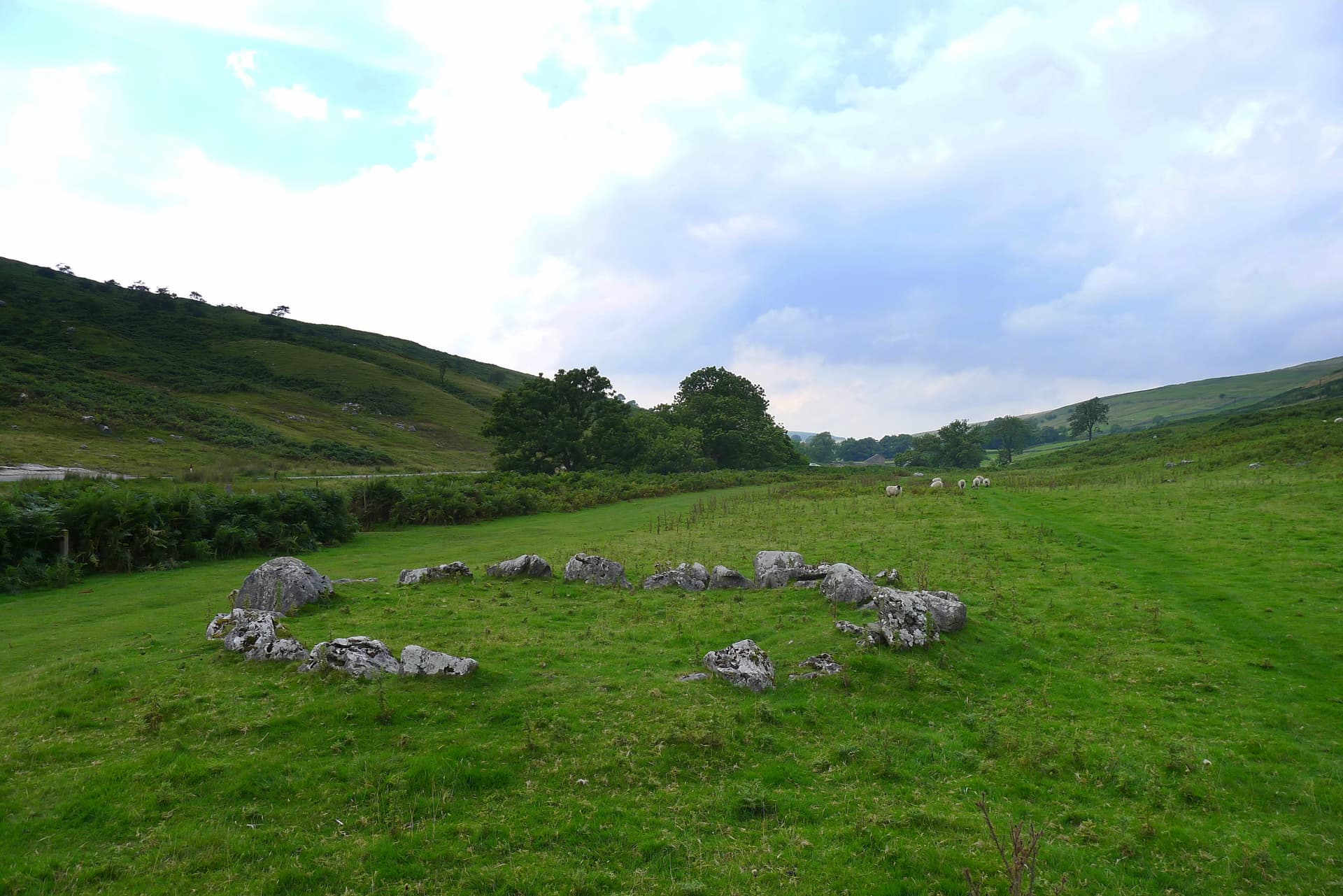
Yockenthwaite stone circle
Buckden, England, United Kingdom
48.4 km away
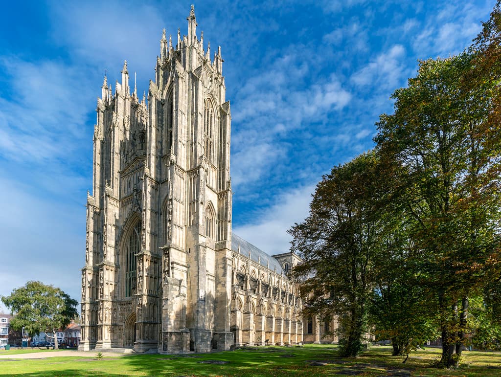
Beverley Minster
Beverley, East Riding of Yorkshire, United Kingdom
70.6 km away
Key questions
What pilgrims usually ask
- Why is The Devils Arrows considered sacred?
- Discover Britain's tallest standing stones west of Boroughbridge. Explore 4,000 years of mystery at this Bronze Age ceremonial site in the Ure-Swale landscape.
- What should I wear at The Devils Arrows?
- There are no dress requirements. Wear practical clothing suitable for walking across potentially muddy farmland. Sturdy footwear is advisable, particularly after rain.
- Can I take photos at The Devils Arrows?
- Photography is welcome and unrestricted. No permits are required for personal use. The stones photograph well at dawn and dusk when low light emphasizes their texture. Consider whether every photograph is necessary, and whether presence might sometimes matter more than documentation.
- How long should I spend at The Devils Arrows?
- A basic visit—parking, walking to all three stones, returning—takes thirty minutes to an hour. Those wishing to sit with the stones, walk the alignment multiple times, or meditate will want longer. Combined with the Thornborough Henges, the area merits a half-day exploration.
- What offerings are appropriate at The Devils Arrows?
- Physical offerings are not traditional and should not be left. The site is agricultural land, not a maintained sacred space; items left behind become litter for the farmer to remove. Internal offerings—silence, attention, gratitude—are appropriate.
- What etiquette should visitors follow at The Devils Arrows?
- The Devil's Arrows require the respect due to both a protected ancient monument and a working agricultural landscape. No active religious practice takes place, so etiquette centers on preservation and respect for the landowner rather than sacred protocol.
- What is the history of The Devils Arrows?
- No founding narrative survives from the people who erected the stones. What remains is the folklore that followed: the Devil, standing on Howe Hill, attempted to destroy the Christian town of Aldborough by hurling massive stone arrows. His cry echoed across the land—'Borobrigg keep out o' way, for Aldborough town I will ding down!' But his aim proved poor. The arrows fell short, landing in the fields west of Boroughbridge where they stand today. This is, of course, a later invention—a way of explaining what could not otherwise be understood. The pattern is common across Britain: stones of mysterious origin become the Devil's handiwork, sacred sites of pre-Christian practice reframed as evidence of Satan's malevolence and failure. The story tells us more about medieval Christian anxiety than about Bronze Age intention. Another variant suggests the stones simply 'sprung up one night in the very places they now occupy'—magical emergence rather than human effort. Both stories point toward the same recognition: that something about these stones exceeds ordinary explanation.
- Who is associated with The Devils Arrows?
- William Camden (historical), John Aubrey (historical), William Stukeley (historical), Alfred Watkins (historical)