New Alresford
A bishop's bridge on the road pilgrims once walked toward Canterbury
Understand sacred places, explore living traditions, and learn how to engage respectfully with Pilgrim Map.
Access has not been verified. Check current local guidance before planning a visit.
New Alresford, England, United Kingdom
Read the sources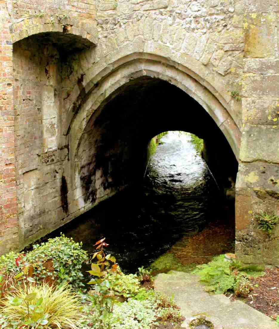
Image of New Alresford. Image source
Visit essentials
A quick read before you go
- Duration
- The bridge and town centre can be seen in under an hour; the full Winchester-to-Alresford…
- Access
- New Alresford is reachable by road (A31) and by the heritage Watercress Line steam railway from…
Overview
New Alresford was not built for pilgrims, though they may have used its road. Around 1200, a Bishop of Winchester deliberately planned the town: damming the River Arle into a great weir and pond to support trade and improve navigation, then laying a T-shaped market town beside it.
The stone Soke Bridge still crosses the old weir site, linking the town materially to the medieval road between Winchester and London and, by extension, routes toward Canterbury after Thomas Becket's murder in 1170.
Clear chalk streams in the Itchen and Arle valleys also made New Alresford England's watercress capital. Its position at the end of the first day's walk from Winchester now gives it a second life as a waypoint on the revived Pilgrims' Way and Old Way. The record does not settle whether medieval pilgrims lingered or passed toward the downs; more certain are the bridge, the bishops who built the town around it, and its later Georgian streetscape.
Why this place is sacred
There is no shrine here, no relic, no origin miracle. What New Alresford offers instead is something rarer in the story of English pilgrimage: a visible piece of the machinery that made travel possible at all.
Bishop Henry de Blois is credited with first conceiving the weir and the town layout in the twelfth century, and his successor Godfrey de Lucy completed the scheme around 1200, damming the Arle to create a navigable pond and laying out a market town, Novum Forum, on the higher ground beside it.
The bridge that still crosses the old weir line — Historic England dates its surviving fabric to the late twelfth century, though a local-history account places the stone rebuild later, in 1307-8, replacing earlier timber crossings — carried the Winchester-to-London road over ground that would otherwise have required a steep descent into the river valley.
That road is also, in part, the corridor later named the Pilgrims' Way, along which travelers moved toward Thomas Becket's shrine at Canterbury following his 1170 murder. The town's sanctity, if the word applies at all, is borrowed from its function: it made the crossing possible for merchants, bishops, and pilgrims alike, and its survival lets a modern walker stand on the same stone arch a medieval traveler would have used.
A dammed weir and planned market town built to improve trade and river navigation on the Arle, with the bridge serving the Winchester-London road that also carried medieval travelers toward Canterbury.
Conceived under Bishop Henry de Blois (d. 1171) and completed under Bishop Godfrey de Lucy around 1200; the bridge was rebuilt or repaired across the centuries (a stone rebuild is dated by one source to 1307-8, with further brick modifications in the 17th and 19th centuries); the town's economy shifted over time from market trade toward watercress cultivation, and its pilgrimage identity has been most recently revived through the modern walked Pilgrims' Way and Old Way.
Experience and orientation
Most people who come to the bridge arrive on foot, having already walked the roughly nine miles from Winchester Cathedral that make up the first stage of the Pilgrims' Way or Old Way. The approach into New Alresford does not announce itself as a pilgrimage site — there is no marker declaring sacred ground, no shrine to orient toward.
What there is instead is a working town: broad Georgian streets, the smell of watercress beds along the Alre, and, on the north side, a single Gothic stone arch spanning what was once the Great Weir. The bridge is easy to underestimate. It carries an ordinary road, has a residential garden backing onto one side, and gives no obvious sign of its age or its listing. Slow down here rather than photographing and moving on.
Notice the stepped buttresses, the narrowness of the single arch built to funnel a much larger body of water than the trickle that runs beneath it now, and the way the road still rises gently from the bridge into the town rather than plunging into the valley the weir was built to avoid. That small piece of engineering foresight, eight centuries old, is the most concrete thing this stage of the walk has to offer.
The Soke/Alresford Bridge is on the north side of town near the site of the former Great Weir and Alresford Pond, visible from public land; St John the Baptist Church stands on West Street. Both are easily combined with a walk through the town's Georgian core and watercress beds along the River Alre.
Context and lineage
Local heritage sources credit Henry (Henri) de Blois, Bishop of Winchester until his death in 1171, with first conceiving the dam and town scheme; his successor Godfrey de Lucy, bishop from 1189 to 1204, completed the project, obtaining a market licence around 1199-1200 and naming the new settlement Novum Forum.
Wikipedia's summary credits de Lucy alone with the founding, while other accounts describe the two-bishop sequence; both attributions are carried forward here rather than resolved, since the sources do not agree.
New Alresford was one of six planned market towns founded by the medieval Bishops of Winchester, one of England's wealthiest sees, and its bridge sits on the road corridor linking Winchester Cathedral (shrine of St Swithun) westward to onward stages of the Pilgrims' Way through Alton, Farnham, and Guildford toward Canterbury Cathedral.
Henry (Henri) de Blois, Bishop of Winchester (d. 1171)
Credited by some sources with first conceiving the weir and town-planning scheme that became New Alresford
Godfrey de Lucy, Bishop of Winchester (1189-1204)
Completed the weir and town scheme around 1200, obtaining the market licence and founding Novum Forum
Traditions and practice
No distinct ritual practice is recorded as centered on New Alresford historically, beyond the ordinary transit of medieval travelers, merchants, and pilgrims along the road the bridge served.
Modern walkers following the British Pilgrimage Trust's Pilgrims' Way or Old Way itineraries pass through the town as the endpoint of the first day's stage from Winchester, sometimes carrying pilgrim passports stamped along the route and pausing at organized rest points.
Walk to the bridge deliberately rather than photographing it from the road. Stand at the crown of the arch and look along the old weir line toward where the pond would have stood, then follow the road's gentle rise into town and notice how the crossing was engineered to avoid a steep valley descent — a small, legible piece of medieval problem-solving that most visitors walk straight past.
If arriving as part of a multi-day walk, treat the stop as a chance to register the change of pace between the open downland already crossed and the enclosed streets ahead, rather than rushing on to the next stage.
Christian pilgrimage (Becket veneration, Winchester-Canterbury route)
HistoricalNew Alresford lies on or near the historic route linking Winchester Cathedral, shrine of St Swithun, to Canterbury Cathedral, shrine of Thomas Becket, one of medieval England's most important pilgrimage circuits after Becket's 1170 murder. The town's bishop-driven founding and its surviving bridge reflect the practical infrastructure that supported travelers, including pilgrims, moving between the two cathedral cities.
Foot and horse travel along the ancient trackway and Roman-road alignment linking Winchester to the routes east; sources note some pilgrims may have bypassed the town itself for safety.
Modern walking pilgrimage (Pilgrims' Way / Old Way)
ActiveThe British Pilgrimage Trust's revived Pilgrims' Way and Old Way itineraries, running from Winchester or Southampton to Canterbury, treat New Alresford as the endpoint of the first day's stage out of Winchester, giving the town a living pilgrimage identity distinct from its medieval one.
Waymarked multi-day walking with pilgrim passports, blessings, and organized rest points ('Sanctuaries') coordinated by the British Pilgrimage Trust; self-guided walking using Cicerone guidebooks is also common.
Perspectives and open questions
New Alresford can be read as a planned medieval town whose pilgrimage association is largely geographic, as a rare surviving piece of episcopal civil engineering, and as a modern waypoint whose meaning has been partly reconstructed by today's revived walking pilgrimage.
Scholarly perspective
Historians and Historic England treat New Alresford primarily as an exceptionally well-preserved example of a bishop-founded planned market town, one of six such foundations by the Bishops of Winchester, with the Soke/Alresford Bridge recognized as a nationally rare early stone bridge. Its connection to the Pilgrims' Way is treated as infrastructural — the town sat on or near the route — rather than as a pilgrimage destination in its own right.
Living and traditional perspectives
Local heritage narrative, carried by Alresford Museum and the town's own history society, emphasizes civic and economic history: the market, the weir, and watercress, with pilgrimage mentioned as a secondary historical use of the surrounding road network rather than a defining identity.
Open questions
The precise volume and character of medieval pilgrim traffic actually passing through New Alresford, as opposed to bypassing it, is not firmly established. One source states that pilgrims avoided the town itself for safety, which sits in tension with its promotion today as the first stage-end of the Pilgrims' Way.
Plan your visit
Access and arrival
New Alresford is reachable by road (A31) and by the heritage Watercress Line steam railway from Alresford station. The Soke/Alresford Bridge is viewable from public land near the site of the former Great Weir on the north side of town; St John the Baptist Church on West Street keeps normal parish church hours. Mobile signal is reliable throughout the town. No booking or keyholder is required for either the bridge or the church exterior.
New Alresford has a range of guesthouses, inns, and B&Bs typical of a small market town; Winchester, nine miles west, offers a wider range of accommodation for those beginning the walk there.
Respectful visit
None specific; standard church etiquette (quiet, modest dress) applies only if entering St John the Baptist Church during services.
Permitted; the bridge and town are public heritage features with no known restrictions.
None documented.
The bridge borders private garden land in parts; view and photograph it from public ground without stepping onto adjoining property.
The bridge sits close to private residential land in places; view it from public ground without trespassing onto adjoining gardens.
Location
Map loads as you approach this section.
Pilgrim reflections
A portrait of encounter, not a score
Pilgrims describe what they felt, how present they could become, and whether the place would shape a journey. There are no stars and no ranking of traditions.
No reviewed reflections yet
The first pilgrims can help describe the character of being here.
Share a reflection
Available after an account-backed “Been there.” Every reflection is reviewed before publication.
Nearby sacred places
Explore other sacred places in the region. Proximity does not establish access or travel time; check each place’s guidance.


References
Sources consulted for this page. Source categories describe the publication, not a guarantee that every claim is verified. Traditional accounts and outside interpretations may differ.
- 01Alresford Bridge, New Alresford - List Entry 1021111 — Historic EnglandofficialGrade II* listing; dates surviving bridge fabric to the late 12th century, built as part of Bishop Godfrey de Lucy's scheme to dam the Itchen/Arle and make the river navigable; describes single Gothic stone arch with stepped buttresses, later brick modifications (17th, 19th century).
- 02The Pilgrims' Way – Winchester to Canterbury – North Downs Pilgrims Way — British Pilgrimage TrustofficialOfficial modern pilgrimage-route organization; describes the 150+ mile route from Winchester Cathedral (starting with Wayfarer's Dole at Hospital of St Cross and blessing at St Swithun's shrine) to Canterbury Cathedral, following the North Downs chalk ridge; confirms Alresford as an early-stage stop.
- 03Old Way Full Route from Southampton to Canterbury — British Pilgrimage TrustofficialDescribes the 'Old Way,' a rediscovered c.1360 Gough Map pilgrim route from Southampton to Canterbury via Winchester, distinct from but related to the Pilgrims' Way; relevant context for the broader network of routes through Hampshire converging near Winchester/Alresford.
- 04Church of St John the Baptist, New Alresford - List Entry 1156507 — Historic EnglandofficialListed building entry for the parish church; direct fetch returned an access error during this research session, so details are drawn second-hand via Wikipedia/alresford.org citations of the listing. Church has 13th-century origins with 14th-century tower, substantially rebuilt 1897-98.
- 05The Medieval Soke Bridge in Alresford — Alresford Museum / Alresford.org (local history society)Source contextLocal-history account of the bridge; gives an alternative construction date (1307-8 stone rebuild replacing timber predecessors) and describes its function carrying the Winchester-London road across the Great Weir, avoiding a steep descent to the river valley.
- 06A Brief History of Alresford — Alresford Museum / Alresford.orgSource contextFounding narrative: Henri de Blois conceived the weir/dam and T-shaped town plan; Godfrey de Lucy (bishop 1189-1204) completed it; town on the Channel-to-London invasion route; notes pilgrims to Canterbury used the route but sometimes bypassed the town itself for safety.
- 07New Alresford — Wikipedia — Wikipedia contributorsacademicGeneral history of the town's founding circa 1200 as 'Novum Forum'; notes proximity to the Pilgrims' Way between Winchester and Canterbury heading east to Farnham, Guildford, Dorking, Maidstone; notes the 13th-century core of St John the Baptist Church with 14th-century tower, rebuilt 1897-98 by Sir Arthur Blomfield.
- 08Pilgrims' Way — Wikipedia — Wikipedia contributorsacademicDescribes the Pilgrims' Way as a 19th-century antiquarian name applied to a pre-existing ancient trackway (archaeological finds dated 600-450 BC, possibly Stone Age origin) associated with pilgrimage to Thomas Becket's shrine at Canterbury following his 1170 murder.
- 09Pilgrims' Way Stages: Winchester to Canterbury — One Step Then Another (walking blog)Source contextContemporary long-distance walking guide; identifies New Alresford as the endpoint of Stage 1 from Winchester (approx. 9 miles). Used only for practical waymarking context, with epistemic caution as an enthusiast source rather than heritage authority.
Share a photo
Help visitors recognize New Alresford. Every submission is reviewed before publication.